
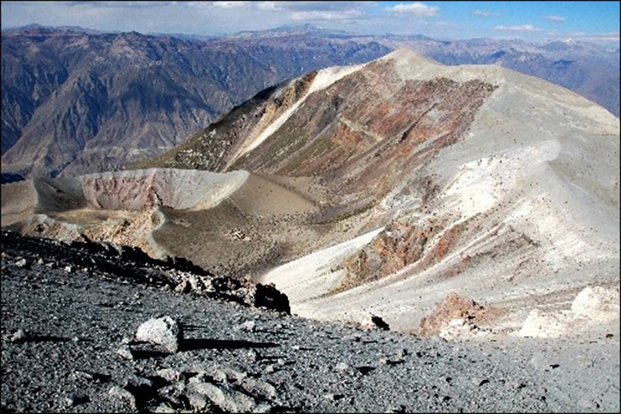
Photo: dockx thierry – Cratère du Huaynaputina – panoramio.com
HUAYNAPUTINA
You might not have heard this name before, or you might know it as just another of the hundreds of Andean volcanoes. But for every volcanoholic Huaynaputina should be a household name like Krakatau – we are going to talk about
the volcano that produced the largest volcanic eruption in South America in historic times, and one of the largest in the world during the past 2000 years.
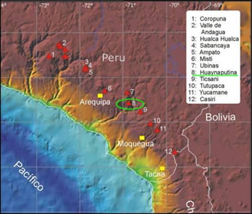 Huaynaputina (from the Quechua language: Waynaputina, meaning “Young Volcano”) lies in Southern Peru’s Moquegua Region, 80 kilometres (50 mi) southeast of Arequipa. The volcano is part of the Central Volcanic Zone. Despite the volcano’s listed elevation of 4,800 metres (15,748 ft), Huaynaputina has very little prominence, no more than 500 m. This is the result of the 1600 eruption when the entire conical edifice was blown apart.

To the west, a roughly rectangular plateau of ash has buried the local pre-eruption topography over an area of about 50 km2. May 1985 TM image of Huaynaputina (16º35’S, 70º52’W)
The mountain sits within a horseshoe-shaped crater 2.5 km (2 mi) in width, and includes three 100-metre (328 ft) deep cones which formed from ash fallout of that eruption. Another external vent formed a maar just outside the caldera. Huaynaputina has produced high-potassium andesite and dacite lavas. To the west, a roughly rectangular plateau of ash has buried the local pre-eruption topography over an area of about 50 km2.
The last eruption before 1600 is believed to have occured 7750 BC +/- 200 years. The shape of Huaynaputina shows it has erupted many times in the past.
HUAYNAPUTINA ERUPTION IN 1600
Almost to the day 415 years ago, on 19 February 1600, Huaynaputina erupted catastrophically (VEI 6). It erupted up to 30 km3 of tephra (or ca. 11 km3 of magma) and is comparable to the Plinian eruption of Krakatau in 1883 – but only to a fifth of the 1815 Tambora eruption. An account of the event was included in Fray Antonio Vázquez de Espinosa’s Compendio y Descripción de las Indias, which was translated into English as Compendium and description of the West Indies in 1942. Many other more or less accurate reports are painting the picture of a terrible catastrophe not easily forgotten by subsequent generations of descendants of the survivors.
The eruption lasted from February 19 to March 6, and consisted of a plinian eruption, dome building, and edifice collapse. The eruption completely destroyed the pre-1600 edifice which was described as “a low ridge in the centre of a sierra”. Ash from the eruption is widespread and still mantles much of the surrounding countryside as far as Arequipa, 80 km away. Surges travelled 13km to the east and southeast and mudflows from the volcano reached all the way to the pacific coast.

Extent of the Huaynaputina eruption in 1600
FIVE ERUPTIVE PHASES
By linking up the events inferred from Spanish chronicles with the lithofacies of the tephra, Jersy Marino et. al. and J.-C Thouret et. al.
Instituto Geofisico del Peru, et al. distinguish five eruptive phases:
1. During the plinian phase on February 19-20, a sustained column delivered a dacitic pumice-fall of ~7 km3 bulk volume. The plinian pumice formed a widespread lobe of ~95,000 km2 within the 1-cm isopach and winds carried fine ash >500 km to the west into the Pacific Ocean. Ascending magma met the waters of a shallow hydrothermal system; hydromagmatic eruption has increased fragmentation of the magma and the intensity of the explosion. At the height of the Plinian phase, the emission rate was estimated above 100,000 tons of magma per second.
2. During the second phase, a dwindling column sent ash falls on proximal to medial areas.
3. During the third ignimbrite-forming phase with interspersed hydromagmatic events, pyroclastic flows 1.5-2 km3 in volume were channeled into the Río Tambo canyon and tributaries. Winds winnowing the ash columns over high, rugged relief dispersed a co-ignimbrite ash over an area of ~ 265,000 km2. A more acidic and more viscous magma was issued during the ignimbritic and subsequent phases, maintaining a highly explosive character.
4. During the fourth phase, a crystal ash fall was deposited when the residual crystal-rich magma was tapped near the end of the eruption.
5. During the fifth phase, ash flows produced surge deposits and lag-fall breccias near vent, ash-flow deposits in proximal catchments, and an ash fall layer in medial to distal areas.
The ignimbrite-forming phase tapped a magma batch richer in silica than the less differentiated plinian magma. The crystal-rich magma of unit 4 was fed by ‘crystal mush’ in a layered magma reservoir and (or) from two magma reservoirs at distinct depths. The geochemical and mineralogical trend throughout the eruption, and preliminary measurements of geobarometers suggest a complex model linking a shallow (6–7 km) magma reservoir to a deeper (∼15 km) reservoir. The total DRE volume (4.6–4.95 km3) of erupted tephra did not lead to caldera collapse
SOME MORE SCIENCE
I was going to include here a some results of the interesting study “Effects of wall-rock elasticity on magma flow in dykes during explosive eruptions” (A. Costa, R.S.J. Sparks, G. Macedonio, O. Melnik; 2009) where the Huayaputina eruption was taken as an exemple for conduit geometry and dyke deformation in explosive eruptions. The text is kindly made available online as an Author’s Copy, so, rather then re-wording and posting parts of it here I would like to recommend this paper to our more scientifically inclined readers.
LOCAL EFFECTS

Ash raining on G. Poma: “Nueva corónica y buen gobierno”. Ash falling on Arequipa during the catastrophic eruption of Huaynaputina in 1600.
Many earthquakes hit the region beginning February 15, with quakes happening every five or six minutes by February 18. By 10 p.m., the quakes were powerful enough to wake people from their sleep. Between 11 a.m. and 1 p.m. on February 19, two major earthquakes hit the region, causing widespread panic. Most structures were destroyed or severely damaged, large landslides occurred, and cracks and deformations appeared in the earth.
At 5:00 p.m. local time on February 19, Huaynaputina exploded. Violently… all hell broke loose. Huge explosions that reminded observers of cannon fire roared from the summit and the gaping crater began to spew burning ash into the sky, the detonations could be heard in Lima. Tidal waves of hot gas and tephra spewed out of the angry mountain. A plume rose from the volcano to a hight of 35 km, reaching the stratosphere. After an hour ash began to fall like snow all over the Andean region. The earthquakes accompanying the blasts were so powerful that the cities of Arquipa and Moquegua were heavily damaged. Pyroclastic flows flowed down the sides of the mountain in all directions. The villages of Tasata and Calicanto were buried beneath more than 10 feet of pyroclastic flows. The Rio Tambo, which lies to the east of the mountain, filled with ash – creating a lahar that shot downstream at high speed. Several villages downstream were wiped out, with all their inhabitants.
The eruption of Mt. Huaynaputina occurred at a strange time in the history of Peru and South America in general. What was formerly the Inca Empire had only been part of Spanish America for a few decades. Conquistador Francisco Pizarro first arrived in Peru in 1528, but the conquest of the Andean region wasn’t really complete until the 1570s. Nonetheless, the Quechua people remained and many still worshiped the old gods even after the Spanish sought to introduce Catholicism by force. In fact many local people believed that the eruption of Huaynaputina was punishment from the Inca god Supay–often characterized as the Inca version of the Devil – and sacrifices had been offered to him at Mt. Huaynaputina in the weeks before the catastrophic eruption. There is no way such a cataclysm could not have been interpreted in religious or apocalyptic terms, both by the Quechua who lived in the region and the Spanish who tried, not always successfully, to rule them.
The aftermath of the eruption was severe and protracted on the people and colonial economy of south Peru. Voluminous lahars swept the Río Tambo valley and entered the Pacific Ocean. Approximately 1500 people were killed, villages were buried, and the town of Arequipa 75 km away suffered havoc from ash fall and earthquakes. The economic ruin was due to the total loss of crops, cattle, and seeds, and to interrupted trade for years. Epidemics, famine, and poverty were added to the general ruin. Over the following months secondary flows that were not directly related to the eruption, kept rushing from the mountain, and chronicles reported the sky being obscured by dust nearly nine months after the start of the cataclysm. It took about 150 years for the affected area to recover from all losses.
Currently an international archaeologic project is put under way to locate and dig out some of the inhabited places that were buried under the ash in 1600, much like in Pompej. A museum is planned for the site to show the historical dwellings at that time, but the results will also give some useful insights to geologists and volcanologists. The begin of the project is set for November 2015 (IGP, noticias – news).
ASH DEPOSITS

Volcano Huaynaputina (Moquegua, Peru) – Deposits of ash and pumice stones from the 1600 eruption in Chichilin area Quinistacas (Moquegua). © Illustrations: Jean-Claude Thouret, Blaise Pascal University, Clermont-Ferrand
In her book “The Parting of the Sea: How Volcanoes, Earthquakes, and Plagues Shaped the Story of Exodus” Barbara J. Sivertsen looks at for how long layers of ash remain in place over centuries. She mentions Huyaputina as one of the best examples, as contemporary accounts can be compared with modern measurements. Eyewitness accounts record that tephra fell in Lima, about 800 km away, and on a ship about 1000 km out to sea. Historical accounts also report that about one meter fell north and west of the city of Arequipa. Today, one-centimeter-thick layers can be found no farther than 200 km northwest of the eruption, not 800-1000 km, and the deposits in the vicinity of Arequipa are only 10 cm thick at best, not one meter thick. These measurements indicate, that deposits in most of the distal ashfall area have now disappeared and that there has been a 90% reduction in the thickness of the original tephra deposits in only 400 years. Nevertheless, the distinct layer of Huaynaputina’s ash can still be found all over the southern Peru region. The ashes and other deposits are used in tephrochronology; they give the gray marker for the year 1600 in the annual ice layers of the Andes and therefore are a valuable indicator in paleoclimatology.
GLOBAL EFFECTS OF THE 1600 ERUPTION
On a global scale, the following summers were some of the coldest in the last 500 years. Sulfur aerosols erupted from Huaynaputina are thought to have entered the Earth’s atmosphere and reflected sunlight, resulting in this global temperature drop. In the Greenland ice core acidity profile, the eruption produced an acid spike larger in magnitude than the Krakatau 1883 eruption (Hammer et al., 1980; de Silva & Francis, 1990) and remarkable optical effects were reported from the northern hemisphere in 1601 (Lamb, 1970). From the ice cores it is estimated that 16 to 32 Mt of sulfur were erupted, while petrologic estimates indicate that most of this sulfur did not exist in the Huaynaputina magma itself (only 2-4 Mt), but may have come from a coexisting vapor phase or a hydrothermal system.

Great Famine of 1601-1603 in Moscow, a 19th-century engraving
Scientists believe that the eruption may have had societal and agricultural impacts worldwide. In a study published in 2008, Verosub and Lippman from the University of California see a connection between the 1600 eruption of Huaynaputina and one of the greatest famines ever to strike Russia in 1601-1603. Verosub sayd, “People have long known about the eruption and have long known about the famine, but no one has previously linked the two,”. During this two-and-a-half-year period, 127,000 bodies were buried in mass graves in Moscow alone. Widespread starvation killed perhaps two million in Russia, a third of the population. The suffering and social disruption were part of the political unrest called the Time of Troubles, which led to the downfall of Tsar Boris Godunov.
The chilling effects of Huaynaputina’s eruption in 1600 were substantial and were felt worldwide. Analysis of tree ring data gathered throughout the Northern Hemisphere indicate that 1601 was, on average, the coldest year out of the last 600. In Switzerland, 1600 and 1601 were among the coldest years between 1525 and 1860. In Estonia, the winter of 1601–1602 was the coldest in a 500-year period. In Latvia, the late date of ice breakup in the harbor at Riga indicates the winter was the worst in the 480 years before today. In Sweden, record amounts of snow in the winter of 1601 were followed in the spring by record floods. In France, the wine production went down and came late that year. Lake Suwa in Japan had it’s earliest freezing in 500 years. The peach trees in China bloomed late. People around the world felt the effects of Huaynaputina’s eruption. Climate at the time could have played a role as well. In 1600, the world was in the midst of the Little Ice Age, typified by harsh winters, springs and summers much cooler and wetter than normal, and shorter-than-average growing seasons. A large volcanic eruption during that period would have depressed average temperatures even further.
MONITORING HUAYNAPUTINA TODAY
“Currently, there is some evidence of reactivation of Huaynaputina volcano, but if it happened, it
would not be as violent as in 1600 AD because this volcano has already lost part of its volcanic edifice (Legros, 1995)“. Losing part of the edifice certainly is but a minor factor, more importantly, after such a voluminous eruption the magma chamber would have emptied out a big lot of its eruptible material and would need a much longer time to rebuild. Nonetheless, even if Huaynaputina erupted in a less dramatic fashion in the foreseeable future, ash, pyroclastic flows and mud flows would be a very real threat to the nearby communities. Therefore, monitoring Huaynaputina has become part of the extensive modernisation efforts made by the IGP in recent years.

The transfer of equipment and accessories was performed by mules. It took them 2 days of ascent and 2 days of descent for the task. (IGP)

Huaynaputina has a horseshoe-shaped amphitheater with a large break in the eastern section, through which the river Tambo begins its way down from ~ 2000 m altitude. Within the amphitheater are 3 craters, 2 dikes and 1 lava dome; a fourth crater, a “maar”, is located south of it. (IGP)

Inside the amphitheater the scientists located and catalogued all existing fumaroles (IGP).

Enjoy! – GRANYIA
PREVIOUS PERU ARTICLES
Volcanoes of Peru 1: El Misti – the Gentleman
Volcanoes of Peru 2: Nevado Sabancaya
SOURCES & FURTHER READING
– Monitoreo de los volcanes Ticsani, Sabancaya y Huaynaputina: Periodo 2006-2012 [Boletin C 53]
– Observatorio Vulcanológico de Moquegua
– Effects of wall-rock elasticity on magma flow in dykes during explosive eruptions, A. Costa et al.
– Massive atmospheric sulfur loading of the AD 1600 Huaynaputina eruption and implications for petrologic sulfur estimates
– Wikipedia, Huaynaputina
– http://volcano.oregonstate.edu/oldroot/CVZ/huaynaputina/index.html
– The Daily Galaxy
– Global influence of the AD 1600 eruption of Huaynaputina, Peru (paywalled)
– NOAA Volcanic Events Database
– The sky rained ashes: the eruption of Mt. Huaynaputina
– Reconstruction and aftermath of the catastrophic AD 1600 Huaynaputina eruption, south Peru
– Volcanic Hazards and Disasters in Human Antiquity, Issue 345 (GSA)
– The Parting of the Sea
– Earth of Fire/Huaynaputina
– http://beingbutmen.blogspot.de/2013/02/today-february-19-2013-is-413th.html


Nicely done, Granyia. Quite the mountain and eruption. Cheers –
LikeLiked by 1 person
Great post, Granyia, and a fascinating (if virtually unknown) volcano. What struck me after reading it was the more general peculiarity about Andean volcanoes, namely the ability to produce paroxysmal high-volume explosive eruptions WITHOUT generating caldera collapse. Huaynaputina, Lascar, and maybe also Quizapu/Cerro Azul in the 20th century (another half-forgotten eruption that deserves a second look IMO). Any thoughts?
LikeLike
I can only give you my thoughts in regard of Huaynaputina at the moment. Of the 30 km3 of tephra produced, only 11 km3 were magma (the rest was the mountain itself). That would be a “hole” of 3x4x1 km, which for sure is a lot, but perhaps not enough for a caldera forming event with highly viscous magmas.
The ejecta came from two different chambers at distinct depths, ~6 and ~15 km (but it seems not to be known, which one produced more, and if they were at about the same location). That divides the amount of magma removed from one place, if it was 50/50, to only abt. 5.5 km3. If most of it came from the deeper source, it may have been unlikely to have caused a caldera anyways.
The erupted lavas have been rich in silica (as far as I can see for all stages of the eruption) and magma mixing from the two different chambers may have taken place. Both accounts for the high explosivity. It may also be one reason for not forming a caldera – and this is just my guess, I’d have to read up – I think that eruptions with very liquid lavas are more likely to cause a caldera than with thick viscous ones. Liquid stuff can be ejected much faster, and the “void”, or re-filled, chamber below the roof must be much softer than with silica rich magmas, thus allowing the roof to sink, or break in easier. — But I am not an expert, perhaps a more geologically trained person could say if this is all rubbish 🙂
LikeLike
Your ideas have prompted me to do a bit of googling around. I found this history of Chile’s Lascar
http://www.google.co.uk/url?sa=t&rct=j&q=&esrc=s&source=web&cd=16&ved=0CDsQFjAFOAo&url=http%3A%2F%2Fwww.researchgate.net%2Fprofile%2FM_Gardeweg%2Fpublication%2F249547028_Evolution_of_Lascar_Volcano_Northern_Chile%2Flinks%2F542d61420cf27e39fa942a5b.pdf&ei=SSQsVfKGO4rnaqDCgLAB&usg=AFQjCNH_bvYYN5ntdO3aBmL6RxSHBBxRWw&sig2=xlTKdWUvg9mF-KS4T-2tag&bvm=bv.90491159,d.d2s
(sorry about all that, it’s a pdf). About 26000 years ago Lascar had a paroxysm like that of Huaynaputina or even bigger (the Soncor ignimbrite) -again, without caldera formation. The authors seem to suggest that this was because of the unusually thick, rigid crust above the magma body (and maybe the depth, and shape of the chamber has some effect too?). Couldn’t find much in English about Quizapu 1932; on a smaller scale only 9.5 cu km (only!) but a spectacular Plinian event for all that. Again, leaving just a large explosion crater, no particularly noticeable subsidence effects.
LikeLike
Of course, if the thickness of crust is a factor…southern Peru has with up to 80 km the thickest crust in the Andes. But I would think the depth of the magma reservoir is more important, if it is very shallow, thickness of the crust should not matter so much. Thanks for the link, I have filed it away under soon to be read!
LikeLike
APOD has a nice photo of Santa Maria in Guatemala today. Cheers –
http://apod.nasa.gov/apod/astropix.html
LikeLike
…and Fuego erupting in the distance. Nice, thank you! Fuego should have risen to the occasion and done something more spectacular, though! 😉
LikeLike
There are two things that really amazed me when I researched the article. The first is the fact that from the Greenland ice core acidity profile it was calculated that 16 to 32 Mt of sulfur were erupted (causing a spike greater than that from Krakatoa), while petrological estimates say that the erupted magma itself did not contain more than 2-4 Mt, which is a mere 12,5%. The rest must have been “hot air”, vapours from hydrothermal output. – So, where does that huge amount of Sulfur gases come from? Does not the hydrthermal system transport only ingredients dissolved out of the near surface magma that it encounters? If it is pure gases, they certainly must have come from degassing of magma, thus also having been in it before?
LikeLike
The second is rather interesting than unbelievable: “Historical accounts also report that about one meter fell north and west of the city of Arequipa. Today, one-centimeter-thick layers can be found no farther than 200 km northwest of the eruption, not 800-1000 km, and the deposits in the vicinity of Arequipa are only 10 cm thick at best, not one meter thick.”
So, where are the 90% of tephra gone? Erosion, yes, further distributed by wind and rain. But, 400 years are no geological time. It is hard to imagine that ~4 km3 deposits (of the total DRE volume of 4.6–4.95 km3) were eroded from such a relatively small area in such a short time.
These two results should probably have played an enormous role in the interpretation of both ice core measurements (my comment above) and tephrochronological studies. If you have a big sulfur spike in the ice core records, it does not necessarily mean a huge eruption has taken place somewhere at that time. And if you have a small layer of ash it does not necessarily mean that no huge eruption has occured.
LikeLike
I need to ask two probably real amateur questions. From yesterday’s report on Ubinas: “Ubinas has been emitting ash continuously and had numerous exhalations and explosions.” You find that mostly (or only?) in spanish reports, in English reports you see phreatic explosions and strombolian/vulcanian eruptions. So, what exactly are exhalations? (As far as I know Ubinas does not have either strombolian or vulcanian activity).
Further down it says: “Moreover, in the last 24 hours it has been observed some drumbeats type earthquakes although weak, which may indicate rise of magma with lower debit”. Is that what GL in VC called chugging, that showed in spectrograms as regular vertical lines through all frequencies?
(http://ovs.igp.gob.pe/drupal/?q=node/42 Report 2015-17)
LikeLike
Video of a lahar from Ubinas, 13 April 2015:
http://www.youtube.com/watch?v=kDdguKyKr4Q
LikeLike
Thanks, Flag. Here’s the GI homepage. Cheers –
http://www.gein.noa.gr/en/
LikeLike
Weekly Smithsonian GVP is up at the link. Cheers –
http://www.volcano.si.edu/reports_weekly.cfm
LikeLike