
Pinatubo in Eruption June 1991 – http://bigthink.com/eruptions/why-volcanism-isnt-the-source-of-increasing-carbon-dioxide-emissions
A long time ago in a galaxy far away, I had the opportunity to do a couple weeks of flying over and around the Island of Luzon in the Philippines. I was temporarily assigned to Clark Air Base, PI taking part in an exercise called Cope Thunder, basically a Pacific Air Forces version of the stateside training called Red Flag. http://en.wikipedia.org/wiki/Clark_Air_Base
Clark Air Base was laid out in the flat part of Luzon, some 90 km NW of Manila. It is surrounded by two volcanoes, one obvious, and the other not so much. Some 16 km to the east of Clark and Angeles City is Mount Arayat, thought to be an extinct stratovolcano that is just over 1,000 m high. It is topped with a crater that is over a kilometer in diameter and a breached crater and debris flow from its WNW summit. There is no modern record of eruptions of Arayat, though there is occasional fumarole activity. From a distance, it is a truly beautiful mountain. When the news of the Pinatubo eruption hit, this was the mountain that I thought had exploded, as it was the only visibly obvious volcano in the area. http://volcano.si.edu/volcano.cfm?vn=273084
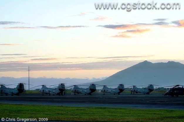
Mount Arayat from Clark AB – http://www.phototour.minneapolis.mn.us/7519
Some 26 km to the WSW of Clark and Angeles City is the Pinatubo complex. From the base, it does not look like a volcano, rather more like a small mountain range. Aviation and topographic maps do depict a roughly circular complex some 24 km in diameter. Its flanks are heavily eroded, with jagged ravines, canyons, and greenery everywhere. Flying around the mountain in early 1979, there were also a couple active fumaroles near the highest point.

Clark AB circa 1989 – http://en.wikipedia.org/wiki/Clark_Air_Base
At the time, there was an active gunnery range on its northern flank called the Crow Valley Range that American aircraft from Clark and Subic Bay used to drop practice ordinance on. The range sat in a river valley between two fairly steep cliffs. It was possible to hide on the other side of the ravine, poke your nose above the top and deliver a rocket or bomb onto the range and then quickly leave line of sight from the target. http://en.wikipedia.org/wiki/Crow_Valley_Range_Complex

Crow Valley Range from the air, mid-1980s – http://en.wikipedia.org/wiki/File:Crow_Valley.jpg
Flying up and down the ravines was great fun as long as you remembered the rate of climb in an aircraft was not necessarily greater than that of the rising terrain you were flying up, especially on a hot Philippine day. Desert terrain in the Western US claims no small number of pilots every year who poke their noses up box canyons they can neither turn or climb out of and figure it out too late to do anything about it. Pinatubo was the second place I tried to kill myself in an aircraft for precisely that reason. Fortunately God had other plans for me.
The other interesting thing about Crow Valley Range was the local natives who lived on the flanks of Pinatubo. The official name of natives was Aeta, which we did not know at the time. However, there was a location named Negrito depicted on the aviation maps very near the range at the time so that is what the military referred to them as.
These guys were entrepreneurial and watched the range complex closely. Following each weapons delivery pass, they would run onto the range and recover brass, steel, shrapnel, and other metals that they would make things out of and sell in Angeles and other cities. This was a source of no small amount of concern for range personnel and fliers, for nobody wanted to put anyone at risk while training. They were also among the first on the crash scene when an aircraft went down, helping the survivor(s) until rescue arrived.

Clark AB after the eruption. Ash damage to buildings. – https://www.awesomestories.com/asset/view/Clark-Air-Base-Damaged-by-Mt.-Pinatubo-Eruption
The eruption of Pinatubo forced the evacuation of Clark AB in 1991. The base which had been in operation since 1903 was eventually returned to the Philippine government. Crow Valley was completely buried under pyroclastic flows and lahars following the eruption, though the area was retained by the government of the Philippines for defense force training after they turned over Pinatubo to the Aeta who claimed it as ancestral ground.
Tectonics
Pinatubo is the northern most member of a string of volcanoes on the western part of Luzon called the Luzon Arc. They are essentially subduction volcanoes. The Philippines is comprised by a number of microplates at the margin of the Philippine Plate as it subducts under the Eurasian Plate. There are subduction trenches to the west of the Philippines and transverse faults on Luzon itself.
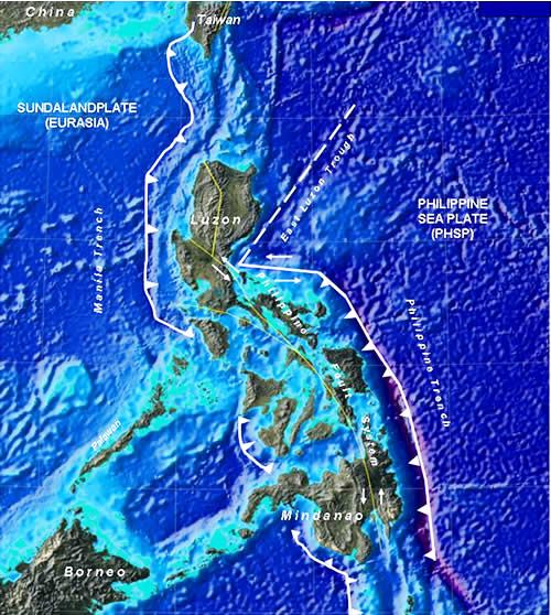
Tectonics of the Philippines – http://thewatchers.adorraeli.com/2011/07/12/a-strong-earthquake-magnitude-6-4-hit-the-philippine-province-of-negros-occidental/
The volcano is underlain by a magma chamber some 6 – 11 km deep. The chamber is thought to contain some 40 – 90 km3 of relatively cool, highly crystalized (up to 50%) mush. The crystal mush was destabilized by an injection of basalt into the chamber and erupted andesitic pumice and ash that shifted into dacitic as the 1991 eruption progressed. Analysis of eruptions over the last 35,000 years indicates that the process observed in 1991 has repeated many times over the period.
Volcano
There are two historic periods for Pinatubo. The ancestral Pinatubo dates back as far as some 1.1 million years (MY) ago. It was an andesite and dacite stratovolcano that eventually destroyed itself, leaving a 3.5 – 4.5 km caldera. There are remains of domes and satellite vents around the complex. It occupies about the same location as the modern Pinatubo.

Pre-eruption Pinatubo – http://historicmajortectonicactivityproject.pbworks.com/w/page/71318835/1991%20Mt%20Pinatubo,%20Phillipines,%20Volcano%20by%20Hannah
The modern Pinatubo started its construction some 35,000 years ago. Its eruptive products are typically loose, with pyroclastic flows, tephras and pumices. Other than dome-building, the destabilized crystal mush produces little lava flows. This leads to significant erosion along the flanks due to the wet climate of that part of the world. The lack of lava was also one of the reasons it took a long time to identify Pinatubo as a volcano, which started taking place in the mid to late 1970s.
The mountain was verified as a volcano following investigations into possibilities for geothermal power in the early 1980s.

Pre-eruption Pinatubo showing fumaroles – http://www.livescience.com/14476-photos-mount-pinatubo-largest-volcanic-eruption.html
Eruptive periods are marked by an intense, short series of eruptions followed by occasional dome building, caldera formation, and years of lahar action as water moves the loose pyroclastic and tephra debris from the remaining mountain. After the eruption(s), there is a period of repose as the destabilized crystal mush stabilizes.
Eruptive periods from 35,000, 17,000, 9,000, 6 – 5,000, 3,900 – 2,300, and 500 years ago have been identified. Volume of magma erupted during these eruptive periods appear to have decreased over time while the period of repose between eruptive periods appears to some to have decreased. There is no small amount of disagreement over the notion that Pinatubo is erupting more often.
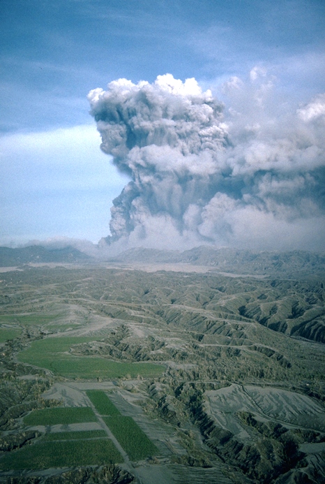
Pinatubo in Eruption June 1991 – http://volcanoes.usgs.gov/hazards/gas/climate.php
Additionally, while the major deposits of an eruptive period are able to be determined, it is not possible to tell how many single eruptions emplaced those deposits. With a destabilized magma chamber and new basalt entering it from below, the possibility of additional eruptions from Pinatubo exists.
Finally, one of the great ongoing threats from Pinatubo is lahars, as rain removes loosely deposited (and welded) tuff, drags it downstream and deposits the material on the lower parts of the surrounding valley in Luzon. This action has gone on for decades after the eruption and is expected to continue. It was worst immediately following the climatic eruption of 1991 which coincided with the passage of a major typhoon. A few months later the monsoon season and its rains started, moving yet more debris downhill.

Post-eruption lahars – http://volcanoes.usgs.gov/hazards/lahar/rain.php
Eruption of 1991
The best compendium of Pinatubo information was put together by a cooperative between PHIVOLCS, University of Washington and the USGS. It is called Fire and Mud and was last updated in 1999. http://pubs.usgs.gov/pinatubo/
The following summary is paraphrased from the Fire and Mud Overview by Wolfe and Hoblitt.
Local earthquakes started in March, 1991. The first phreatic eruption took place on April 2. Continuing earthquakes from June 1 – 7 localized the activity at the throat of the volcano. There was dome-building from June 7 – 12. Four brief vertical eruptions accompanied continuing buildup of tremor and earthquakes. June 14 – 15 saw 13 brief surge producing eruptions that became progressively closer together until the 9-hour long climatic eruption on June 15. Continuous ash emissions continued until mid-late July, tailing off along with earthquake intensity over the period. Small ash eruptions continued until early September. It was followed by dome-building through October 1992.

Pinatubo in Eruption, June 1991 – http://www.pbslearningmedia.org/resource/ess05.sci.ess.earthsys.lahar/mount-pinatubo-the-aftermath-of-a-volcanic-eruption/
Some 500,000 lived close enough to the volcano to be at risk from lahars following the eruption, with some 35,000 living on the flanks on the actual volcano. Ash coverage stretched from the Philippines to Southeast Asia.
PHIVOLCS progressively raised the level of alert during the increase in activity and started evacuating people off the mountain and from close to the mountain. This kept the death toll from the eruption and following lahars to around 800. There were some 100,000 left homeless following the eruption.
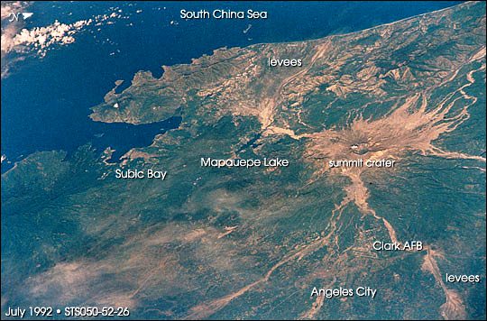
Post Eruption Pinatubo from space – http://earthobservatory.nasa.gov/Features/AstronautPinatubo/
The eruption was the second-largest measured in the 20th Century, ejecting some 8.4 – 10.4 km3 of tephra and pyroclastic deposits. It was also Sulphur-rich injecting some 17 megatons (Mt) of SO2 into the atmosphere. The eruption was also water-rich, ejecting up to 921 Mt of water. The high volatile content of the crystal mush is one of the reasons that the eruption was so explosive in nature. The plume was measured by radar and has been estimated as high as 34 km during the climatic eruption.
The SO2 and ash injected into the atmosphere has been blamed for global temperature impact (overall cooling for a year or two), though like all things climate these days, there are those who disagree with these conclusions.
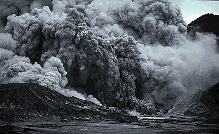
1994 Small eruption – http://volcano.oregonstate.edu/vwdocs/volc_images/southeast_asia/philippines/pinatubo.html
Conclusions
Pinatubo is the first example of a large volcanic eruption in a relative modern, densely inhabited area. This time around, the governments involved gave timely warnings and managed to get the people out of the danger zone as it grew. While the property damage and loss was very large, the actual cost in human life for such a large eruption was relatively small.
This was the first huge eruption that was closely monitored, that is until the eruption destroyed emplaced seismographs and other devices. It will not be the last one.

Pinatubo Caldera Lake – Present day -http://www.markmaranga.com/mount-pinatubo-eruption-and-climate-change/
Additional information
http://pubs.usgs.gov/pinatubo/cbautist/
http://pubs.usgs.gov/pinatubo/rodolfo/index.html
http://pubs.usgs.gov/pinatubo/prelim.html
http://pubs.usgs.gov/pinatubo/
http://bigthink.com/eruptions/the-20th-anniversary-of-the-eruption-of-pinatubo-in-the-philippines


Hi Agimarc, thanks a lot! That must have been exiting times, even though some work might have been involved too. 😉 Were you already interested in volcanoes back then? The same as I keep wondering what makes people choose a volcano for the best place to live, I don’t understand why they would keep a huge expensive military base near a potentially active volcano. They might not have known for sure when they first built it in 1903, but I read it was greatly extended and flourished best from 1945 to 1990.
LikeLike
Howdy Granyia –
I was (and still am) interested in things that went boom – which included volcanoes. This led me into the bombs and bullets business and into amateur volcanology and amateur astronomy (meteors, comets and bolides) over the years. It is an interest that grew slowly and fitfully over that time. You can see a lot more interesting stuff from the air than you can from photos and maps.
Interesting part of this is that Pinatubo was not identified even as a volcano until sometime in the 1970s – 1980s. By that time, the base had been there for a long time. Like I noted in the post, it was only confirmed as a real volcano with fumaroles in the early 1980s. Like we are seeing elsewhere, when you look at the same thing with different or differently educated eyes, you see different things. In Pinatubo’s case, it went from a pile of sand to a remarkably dangerous volcano capable of puking out 10 km3 in an 9-hour eruption.
Hope all is well with you and yours. Cheers –
LikeLike
Additional thoughts: Clark was one of the primary places that supported Vietnam war during the 1960s – early 1970s, which led to most of its growth.
The more I think about it, the more I believe the military planners focused on Arayat as the closest and most dangerous volcano to the base, and it hadn’t had any activity in recorded history. At the time, Taal was the next closest active volcano, some 190 km south of Clark. It took a long time to identify Pinatubo as a volcano. Cheers –
LikeLike
Writing from memory, it could take me a while to look up the reference, but I think the first geologist to mention Pinatubo by name (late 19th C) was a distinguished German Herr Doktor Professor, who opined that, while he couldn’t explain the geology of the massif, he was sure it was NOT a volcano. Was he ever wrong 🙂
LikeLike
Here are some volcanic news and updates of this week:
VOLCAN GUALLATIRI, Chile
May 31: (SERNAGEOMIN) A yellow technical alert has been issued for Volcán Guallatiri or Wallatiri in northern Chile on the grounds of volcano-tectonic earthquakes and deformation changes.
GVP: One of northern Chile’s most active volcanoes, Volcán Guallatiri is a symmetrical ice-clad stratovolcano at the SW end of the Nevados de Quimsachata volcano group. The 6071-m-high Guallatiri lies just west of the border with Bolivia and is capped by a central dacitic dome or lava complex, with the active vent situated at its southern side. Thick lava flows are prominent on the lower northern and western flanks of the andesitic-to-rhyolitic volcano. Minor explosive eruptions have been reported from Guallatiri since the beginning of the 19th century. Intense fumarolic activity with “jet-like” noises continues, and numerous solfataras extend more than 300 m down the west flank.
Seen from lake Chungara: the Nevados de Quimsachata. Fltr: Cerro Humarata, Acotango Volcano, Cerro Capurata. Guallatiri Volcano. Photo: Gerard Prins

The current alert levels for Chilean volcanoes are now:
– Villarrica ORANGE – Calbuco YELLOW – Chaiten YELLOW – Copahue YELLOW – Guallatiri YELLOW
VOLCAN WOLF, Ecuador
June 2: (IG-EPN) Galapagos Special Report No. 3-2015
Volcano Wolf is still erupting, albeit less intensely now. On 29 May an overflight has been conducted to assess the state of the eruption. Although clouds had been hampering the task, some thermal images could be taken to roughly map the lava flows, which mainly went down the SE to NE slopes and to a lesser extent to the W.
One unusual feature of this eruption is the fact that it has no ash emission (except for the initial blast) but an extremely high output of SO2. The report states: “SO2 concentration peaked at more than 5000 ppm (Fig. 8). SO2 flow of 40,600 tons/day based on that journey, with a wind speed of 5 m/s (NOAA source) and a main direction towards the NW (Fig. 9) was calculated.”
Hot spot imagery from MODVOLC Hawaii shows the daily lava heat source on Volcan Wolf:
VOLCAN COTOPAXI, Ecuador
June 2: (IG-EPN) Cotopaxi Special Report No. 2-2015
The seismic activity of the Cotopaxi volcano has been showing changes since mid-April this year, accentuating them in May. In May 3000 local earthquakes have been recorded, including a higher number of VLPs (very long period events). This increase is significant compared to 628 events recorded in April, as also observed during the 2001-2002 crisis, which was the most important in the last 15 years.
Additionally to the number of earthquakes, the valuesof their seismic amplitudes recorded at the nearest to the crater (BREF) station, also show an increase in May. The associated seismic energy corroborates this increase. Also since May, there has been an increase in the crater fumaroles, visible even at times from Quito. Additionally reports of climbers indicate that during the weekend of 22 and 23 May the sulfur smell was very intense, especially at 5700 m high on the northern flank of the cone.
GUNUNG SINABUNG, Indonesia
June 3: (PVMBG) RED allert has finally been called for Sinabung. After the previous lava dome collapse in April a new dome has been growing to about twice the size of the last one, fears are now that this could lead to a still more dramatic collapse event. Falling of incandescent rocks and pyroclastic flows have already started at the end of May. Also seismic activity that indicates higher internal pressure and/or arrival of new magma has been recorded during the last days. According to the procederes for red alert, over 6100 inhabitants of villages in the 7km radius have been evacuated, additionally to the ones that had still not been allowed back home since the beginning of the eruptive period in 2013.
The lava lobe on Sinabung’s upper SE flank on 3 June 2015 (Beidar Sinabung/facebook)

LikeLike
If one were inclined to the fantastical, one might see the toe of that lava lobe as the snout and head of a classic Dragon, just awaiting the right moment to breathe fire…..
LikeLike
True… 😀 But this dead one has more life in it as any classic dragon ever had; not only can it bite and breathe poison on you, it can throw a whole mountain on your village!
LikeLike
A Mg 6.0 Earthquake (depth 10 km?) hit Mt. Kinabalu in the NE corner of Borneo (Sabah, Malaysia) this morning at 07:15 local time (23:15 UTC). This is quite an unusual area for EQs of that magnitude. About 40 climbers had to be rescued as slopes had become unstable and aftershocks caused rockfalls (another M 4.7 happened just now, 15.33 UTC). One prominent rock feature of the mountain, the “Donkey’s Ears”, had one “ear” broken off in the event.
Posted on Twitter by Masidi Manjun (@MasidiM)
Mount Kinabalu is split down the middle by a 1 1/2 kilometer deep gorge. This led people to assume that the mountain was an old volcano. However, recent evidence proves differently. It reveals Mount Kinabalu as the youngest granite pluton in the world, which has probably been uplifted by complex tectonic interaction of the subduction forces that work on its neighbors Sulawesi and the Philippine islands. Following the uplift, glacial and weather erosion denuded the batholith of its sediment cover. Mt. Kinabalu is now part of the Crocker Range and with its 4100m it is the highest mountain in the Malay Archipelago.
from http://www.mount-kinabalu-borneo.com/mount-kinabalu-geology.html and
http://www.searchanddiscovery.com/documents/2009/30084balaguru/index.htm?q=%2Btext%3Adj
LikeLike
Howdy Granyia – there is a place called the Landslides Blog hosted by a geologist in Britain who specializes in landslides. As this was not active volcanic event, it will likely show up over there at some point. The earth does some interesting things over time under the actions of gravity, water and ice. Best to you and yours. Cheers –
Addendum: He already has a post up on the slide. http://blogs.agu.org/landslideblog/
LikeLike
Very nice article Agimarc, the more so with the vintage photos. The final dome of Sinabung has a real nasty look.
The landslide blog is really very interesting, you learn a lot from it.
LikeLike
OT: I have known Dave Petley’s blog since even before I got interested in Volcanoes. On 4 Jan. 2010 there was a massive rockslide in Atta abad (northern Pakistan), blocking the Hunza river completely, creating Lake Gojal who’s level rose consequently to over 100 m depth and up to 21 km length in the narrow valley, inundating all villages, fields, bridges and the Karakorum highway to China on its slopes. Everyone was concerned about the loose rubble dam breaking and causing death and destruction down the entire valley and still further down at Tarbela Dam and water works. Very carefully a spillway was hewn or blasted out for the time when water would reach the top. In May/June that year the water begun overtopping the dam. That was a nerve racking time for all involved and even for us onlookers, as now the danger of the dam breaking was greatest. Dave Petley kept a blog with daily or more updates, with pictures, infos, rumors, decisions taken, decisions discarded, theories how to solve the problem etc. In the end, government couldn’t agree on any action and did nothing. And guess what? The dam thing is still there! But it seems to be running out through erosion, as its length on Google maps is now only abt. 11 km.
Photo: Zulfiqar Ali Khan
During this time the Pamir Times also reported daily, especially with wonderful footage by Zulfiqar Ali Khan (not the Marshall!) (sadly, the pictures have been removed from the site since). For a long time afterwards I still followed “Dr. Dave”‘s blog, and I read the Pamir Times to find out how the 25 000 displaced people were faring. Bad enough it was for them. Even now, for anyone interested in that lovely corner of the world, the Pamir Times is the newspaper to read!
LikeLike
Howdy all – Latest report from the Smithsonian Global Volcanism Program for the week of May 27 – June 2. Cheers-
http://www.volcano.si.edu/reports_weekly.cfm
LikeLike
Sadly, 19 people (all hikers/climbers) have been killed on Kinabalu in the earthquake, and considerable damage has been done to houses and infrastructure. http://earthquake-report.com/2015/06/04/very-strong-earthquake-borneo-on-june-4-2015/
LikeLike
Without being asked not to report on earthquakes is the earthquake swarm in Crete at the moment something to keep an eye on .
Since the 5.4mg 7 hours ago there have been 16 further earthquakes.
http://www.emsc-csem.org/#2
LikeLike
There was an earthquake of magnetude 3.3 in bardarbunga caldera today. According to Jon it was a long period event, which means it was magmatic in nature and it occured at a depth of 6.3km.
http://www.jonfr.com/volcano/?p=5695
LikeLike
There is also an earthquake swarm happening on the Reykjannes Ridge .
http://en.vedur.is/earthquakes-and-volcanism/earthquakes/reykjanesridge/#view=map
LikeLike
Sinabung:
It appears that at least 6 pyroclastic flows hit the villages to the S and SE yesterday (13 June), but the lave dome is still up.
The lava dome in itself is a great source of concern as it has grown to double the size of the previous ones. But that’s not all: apparently new cracks appeared in the rocks beside it which could mean that not only the dome comes tumbling down but also a chunk of the mountain itself.
For frequent updates I recommend the tweets of Leopold Adam
LikeLike
A new post is up!
LikeLike
hi
LikeLike
Us
LikeLike
Pingback: Mount Banahaw, PI The Mystic Mountain |
Mount Pinatubo on Luzon Island Which I think started this thread, has recently started producing hundreds of small earthquakes since since the beginning of March. It has now been officially upgraded from 0 to 1 on the Dost website.
LikeLike
Hi Brendan, thanks for the info! Yes, we had noticed the upgrade on 4 March. I don’t think it is a matter of concern, though, since access to the crater is not even restricted yet. Also, they detect very few volcanic earthquakes (VT), no more than is normal background activity. Most of the swarm are due to local tectonic or hydrothermal activity.
At least that is what I read in the reports, I have no other reliable source to go by.
-Gr
LikeLike