

Overhead view of Guacha caldera in the Altiplano – Puna Volcanic complex http://volcano.oregonstate.edu/book/export/html/587
Ran across this complex during the research on my previous article on the Nevada – Utah ignimbrite outbreak. The paper suggested that the tectonics driving activity in Altiplano were similar to that of Nevada – Utah as were the ignimbrites erupted. The major difference is that Altiplano is much more recent starting some 10.4 MA and continuing until relatively recently.

Uturuncu volcano in the Altiplano http://volcano.oregonstate.edu/volcan-uturuncu
Erik Klemetti wrote about this region three years ago in a post about inflation underneath the Uturuncu volcano in Bolivia. https://www.wired.com/2013/07/what-lurks-beneath-the-central-andes-volcanoes-magma/.
General
The Andean Volcanic Belt describes the volcanoes along the Andes in South America. It is generally divided into four regions. The Northern Volcanic Zone is located generally in Columbia and Ecuador. There is a break as you travel south of the offshore Nazca Ridge until you arrive at the Central Volcanic Zone which is located generally in southern Peru and Northern Chile. It also extends eastward in far western portions of Bolivia and Argentina. The southern end of Chile is divided into the Southern Volcanic Zone and the Austral Volcanic Zone. Line of demarcation between the two zones is roughly the Chile Rise, a spreading center between the Nazca Plate to the north and the Antarctic Plate to the south.
Generally, the volcanic activity of the Andes is driven by subduction of the Nazca Plate eastward under South America for the Northern, Central and Southern Volcanic Zones. Subduction of the Antarctic Plate under South America drives activity in the Austral Volcanic Zone.

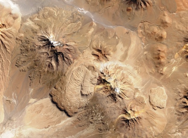
General layout of Altiplano – Puna volcanic complex http://www.earth-of-fire.com/article-les-andes-zone-volcanique-centrale-l-altiplano-puna-volcanic-complex-68673912.html
The border between Chile and Peru is as good as any place to divide the Central Volcanic Field. There are 16 volcanoes in southern Peru. Two are currently listed as active – Sabancaya and Ubinas. The zone includes Huaynaputina which erupted over 30 km3 of dacitic tephras in 1600. Granyia wrote four excellent posts on volcanoes from this portion of the field over the course of the last couple of years:
- El Misti – https://volcanohotspot.wordpress.com/2014/11/02/volcanoes-of-peru-1-el-misti-the-gentleman/
- Ticsani – https://volcanohotspot.wordpress.com/2016/08/25/volcanoes-of-peru-4-ticsani-of-the-three-domes/
- Huaynaputina – https://volcanohotspot.wordpress.com/2015/04/12/volcanoes-of-peru-3-huaynaputina-catastrophe-in-1600/
- Nevado Sabancaya – https://volcanohotspot.wordpress.com/2014/12/08/volcanoes-of-peru-2-nevado-sabancaya/
The portion of the field that lies south of the Peruvian border has at least 63 volcanoes mostly in Northern Chile and far western portions of Bolivia and Argentina. At least two of these – Guallatiri and Lascar are currently considered active.

Altiplano ignimbrites from space. Annotated photo. http://jgs.geoscienceworld.org/content/173/5/734
The southern portion of the field is also home to a field of nested calderas that erupted over the last 10.4 Ma. The eruptions deposited over 15,000 km3 of pyroclastic flows and tephras over an area of 50 – 70,000 km2. There are papers out with estimates as high as 30,000 km3 of ejected ignimbrites. Elevation of the field is some 4,600 m.
While the field is not currently erupting, there have been recent silicic dome formation and flows. The region also has two large active geothermal fields.

Low velocity zone under the Altiplano http://userpage.fu-berlin.de/~mtag/Boli02-NChile04.html
Seismic mapping of the field had an interesting evolution with each pass growing the magma body and putting it closer to the surface.
The oldest seismic studies have found a low velocity zone some 19 km under the surface. This has been interpreted as the active magma body inserted as a sill around a kilometer thick. Another interpretation is that the magma body is located 14 – 16 km deep and overlain with a zone from 10 – 14 km deep with partial intrusion or partial crystallization. Geochemical analysis of the ignimbrites tend to support the larger, shallower model.
A more recent analysis of seismic images find a 200 km diameter, 11 km thick low velocity zone containing a half a million km3 of crystal mush with perhaps 25% melted. The zone lies from 4 – 25 km deep and is one of the larger magma bodies imaged on earth so far.

Nazca Plate subduction under Central Volcano Zone over time http://www.geo.arizona.edu/geo5xx/geo527/Andes/tectonicandes.html
Tectonics
The plateau is some 350 – 400 km wide and 1,800 km long. Uplift was done in the absence of continental collision, though the Nazca Plate subduction drives its magma supply. Uplift instead has been driven by crustal thickening starting some 25 Ma for the Altiplano and some 5 – 10 Ma later in the Puna.
The volcano complex sits on what was the thickest part of the crust, some 70 km thick.
It appears that around 10 – 12 Ma ago, the spreading at the Pacific Rise accelerated, leading to a faster subduction rate and in turn higher heat intrusion into the upper crust.

Surface tectonics of the Altiplano https://www.researchgate.net/figure/252445297_fig1_Fig-1-Tectonic-map-of-the-Central-Andes-modi-fi-ed-after-Kley-et-al-1997-Baby-et
There is some dispute about what is actually going on underneath the Altiplano – Puna. On one hand, I have come across papers which describe it as relatively normal flat slab rollback not unlike what we saw with the Farallon Plate underneath the Southwestern US producing ignimbrite outbreaks from Nevada to Colorado some 30 Ma ago.
There is another paper that describes the action as delamination of the thickening crust under the Altiplano – Puna. As the continental crust portion underneath the Altiplano thickens, part of it delaminates, detaches, and starts being subducting into the mantle beneath the Altiplano. This provides an opening for new, hot Asthenosphere rock into the region under the Andes that used to be underlain by continental crust. The end result for both scenarios is identical, as are the magmas for that matter. How we get there is different.
The long-lived nested calderas suggest that the magma chamber was constructed from plutons that were composite bodies built over several million years. Ignimbrites ejected are chemically similar to those from the ignimbrite outbreak in Nevada – Utah – Colorado some 30 Ma ago.

Map of Altiplano ignimbrites and calderas https://www.wired.com/2013/07/what-lurks-beneath-the-central-andes-volcanoes-magma/
Calderas
The largest is the La Pacana Complex which measures some 100 x 70 km in diameter. This has several distinct ignimbrite centers that overlap, the largest of which is the La Pacana caldera measuring 65 x 35 km in diameter. The complex also contains Cerro Guacha and the Purico complex. Purico dates at 1.3 Ma. La Pacana was active between 5.6 – 2.3 Ma. Cerro Guacha has at least two collapses followed by resurgent dome building. One of these was dated at around 4.1 Ma. The most recent activity from La Pacana came from Purico less than 10 ka.

Schematic of La Pacana caldera, ignimbrite and underlying low velocity zones (magma chambers). Top part is relative velocity anomalies http://www.andeangeology.cl/index.php/revista1/article/view/V42n3-a02/html
The Cerro Pastos Grandes caldera complex is the source of three ignimbrites dated at 8.1, 5.6 and 3.2 Ma. Most of the recent activity (less than 10 ka) has been rhyolite flows and dome building.
Cerro Panizos has an eruptive history spanning several millions of years.
No ignimbrites newer than a million years old are known in the field, but there are active thermal fields and young silicic domes built since then. The domes are chemically similar to the ignimbrites and are interpreted as leaks from the magma body below.

Map of eruptive centers and ignimbrite sources in the Altiplano https://www.researchgate.net/figure/249551892_fig2_Fig-2-The-Altiplano-Puna-Volcanic-Complex-APVC-Inset-shows-location-of-area-in-South
Ignimbrites
Ignimbrite volcanism appears to have migrated south in the Central Volcanic Zone. The Oxaya Formation appears to be the earliest at some 18 – 23 Ma. It is located around 18 degrees 30’ S. Next is the Altos de Pica Formation dated at 15 – 17 Ma. Altos is located at 20 degrees 30’ S. Finally, at the Altiplano between 21 – 26 degrees S, no ignimbrites are measured older than 10.6 Ma.
The ratio of ignimbrites to andesites is estimated at 6:1 throughout the region, meaning that while there is significant lavas observed, there are much more ignimbrites.

Eruptions over time. Calderas depicted. Ignimbrite sheet coverages depicted. Dates depicted. http://gsabulletin.gsapubs.org/content/123/5-6/821.abstract
Activity took place in three main pulses centered around 8.4 Ma, 5.5 Ma and 4.0 Ma. While there was some ignimbrite activity before the first pulse, it was relatively small, ejecting relatively small volumes on the order of hundreds of km3 from a variety of locations around the region.

Tara ignimbrite welded tuff. Location near Argentine border. https://volcanoadventures.wordpress.com/2010/12/
The first pulse ejected the Vilama and Sifon ignimbrites, at least 2,400 km3 of magma over an 80,000 year period starting in 8.4 Ma.
The second pulse was near simultaneous eruptions from three of the major calderas ejecting the Ma Pujsa, Ma Guacha and the Ma Chuhuilla ignimbrites. The pulse lasted around 200,000 years, ejected over 3,000 km3 of magma and ended 5.45 Ma.
The third and final pulse was the largest ejecting the Ma Puripicar and Ma Chaxas and the Ma Atana ignimbrites. Total ejecta was greater than 3,100 km3 of magma (Dense Rock Equivalent – DRE) and the pulse ended 3.96 Ma.

Depiction of ignimbrite sheets from various eruptions. http://gsabulletin.gsapubs.org/content/123/5-6/821.abstract
The final pulse was followed by two more VEI 8 eruptions.
The first produced the Tara ignimbrite which was recognized in 2009. It dates from 3.5 Ma, appears to come from the Guacha caldera, and is estimated at some 750 km3 DRE in volume.
The second is sourced from the Pastos Grandes caldera around 2.9 Ma and has a volume of some 820 km3 DRE. It is also the youngest super eruption from the field, which also means that Pastos Grandes is the youngest resurgent caldera in the field.

Yardangs from poorly welded tuff as parts of Altiplano ignimbrites https://www.researchgate.net/publication/223800611_Yardangs_in_terrestrial_ignimbrites _Synergistic_remote_and_field_observations_on_Earth_with_applications_to_Mars
Since that dating, two more sheets were dated. The first from Ma Alota in 5.23 Ma and the second from the Ma Laguna Colorada center dated 1.98 Ma. In all, some 13 sheets have been dated.
Activity in the field is described as consistent with incremental construction of a pluton / composite Cordilleran batholith which would be the magma body. Large silicic volcanic fields on the surface are generally interpreted as indicators of batholith formation at depth.
Overhead view of Cerro Chao coulee and multiple lava flows http://earthobservatory.nasa.gov/IOTD/view.php?id=82424
Recent Activity

Ground level photo of the front of dacite lava flow pictured from space above http://www.geology.sdsu.edu/how_volcanoes_work/Thumblinks/chaocoulee_page.html
There were several dacitic lavas erupted since 100 Ka. The largest is Cerro Chao, a 14 km long coulee with a volume of 26 km3. They were erupted in three phases with the middle phase depositing 22.5 km3 covering some 53 km2. The lavas share a chemical similarity with relatively recent ignimbrites and either represent the waning of the system or a new episode fueled by intrusions of new magmas into the magma body.
Addendum
Granyia pointed out a new paper “Surface Uplift in the Central Andes driven by growth of the Altiplano Puna Magma Body.” http://www.nature.com/articles/ncomms13185
The magma body underneath the Altiplano is the largest imaged magma reservoir on earth. It contains around 500,000 km3 of partial melt 10 – 20 km below the surface. The melt is thought to be equal parts crust and mantle sources. The magma source is not static, being supplied from below leading to substantial uplift throughout the region. At its greatest, the uplift approaches a kilometer above the surrounding mean elevation.
There were an estimated 12,800 km3 dense rock equivalent (DRE) of magma ejected from the Altiplano over the past 11 Ma. Total thickness of the ignimbrite sheets across the region is 0.7 – 1.0 km. Current growth rate of the underlying magma system is modeled to exceed that of the Sierra Nevada flareup some 30 Ma. The Uturuncu volcano in southern Bolivia is on the northern flanks of the uplifting dome.
The paper detailed a modeling exercise intended to properly characterize the underlying magma body and its growth over time. Well worth your time to read.
Conclusions
The eruptive history of the complex is massive eruptions followed by extended periods of inactivity (millions of years) as the magma reservoir recharges. The closer we look at the magma body, the larger it gets. Given the inflation under Uturunku volcano which was constructed on ignimbrite sheets, the active geothermal sheets, and the recent dome building and silicic lava activity there is no reason to believe that this field is finished. On the other hand, we are not reprising our perennial super eruption watch for a Yellowstone sized eruption in this part of South America either.

Additional information


Thanks agimarc, great article! And how fitting that Sabancaya decided to coincide! 😉
LikeLike
IGP (OVS) officially declare the start of a new eruption in Volcan Nevada Sabancaya after 18 years: from the first week of October there was a notable increase in Hybrid events (earthquakes associated with the rise of magma) – in recent weeks volcanic gas emissions have increased significantly, with values of up to 7173 Ton / day on 23 October. Likewise, on November 2, the MIROVA system detected for the first time a thermal anomaly of 1 Mw in the area of the volcano itself. The population closest to Sabancaya is located 20 km to the northeast in the Colca valley but in the vicinity there are some hamlets and camelid-farming communities. Alert level YELLOW is continued.
Click to access comunicado_conjunto_no03_volcan_sabancaya.pdf
I’m bringing over my comment from last post to have the Sabancaya stuff together here. And I have added a timelapse GIF:
Continuous ash emissions up to 1500m from Sabancaya (PE) volcano for at least several hours:
https://twitter.com/volcanohotspot/status/795708032822939653
LikeLike
Interesting how Sabancaya’s activity also shows up on the seismic stations of the other volcanoes in the region: El Misti 74km – Ubinas 119km – Ticsani 170km away. Ubinas might have reacted a bit faster as it is restless anyway. It is as if the magma in the “big bowl” is “sloshing around” from Sabancaya’s hickup.
(Click on the image to open a large version)

EDIT: Sorry, a mistake: Ubinas should read 10:30 instead of 11.30 on the image.
LikeLike
Howdy all – Moving a Granyia offline comment to the greater blog for your consideration:
Huge “lake” discovered 15 kilometres under Uturuncu volcano – the unexpected water, which is mixed with partially melted magma, could help to explain why and how eruptions happen. This water may also be playing a role in the formation of the continental crust we live on, and could be further evidence that our planet has had water circulating in its interior since its formation…
Article
https://www.newscientist.com/article/2111460-huge-lake-discovered-15-kilometres-under-volcano/?utm_medium=Social&utm_campaign=Echobox&utm_source=Twitter&utm_term=Autofeed&cmpid=SOC%7cNSNS%7c2016-Echobox#link_time=1478381410
Paper (paywalled)
Giant magmatic water reservoirs at mid-crustal depth inferred from electrical conductivity and the growth of the continental crust
http://www.sciencedirect.com/science/article/pii/S0012821X16305805
LikeLike
I think the above reprises the breathless reporting of water in the deep mantle some 30 months ago. The discovery was a hydrated mineral called ringwoodite in a layer some 410- 660 km below the surface.
http://www.livescience.com/46292-hidden-ocean-locked-in-earth-mantle.html
I think we have the same routine going on with the above story. We know that melt from subducted plates have significant water in it, which was brought along the plate as it dove under the continent. The wet melt rises, mixes with basalt and melted crustal rocks as it forms magma chambers. The magma chamber under the Altiplano is really big. If a percentage of the magma chamber is water, then doing the math leads you to another really big number. It is not a magmatic water reservoir. Rather is is magma with a percentage of water and volatiles. Generally, the wetter the melt, the more explosive the eruption as the water flashes to steam (see the link to popcorn rocks in the last post) depressurizing on the way to the surface.
This is not journalism. It is chicken-little scaremongering. My uninformed opinion only. Cheers –
Note: this is aimed entirely at the journalists and the headline writers, not the scientists involved nor my esteemed colleague on this blog.
LikeLike
Well, I’m not going to defend anyone, but it wasn’t journalists who have done the research, it were proper scientists. Nor am I a scientist to be able to say if 10 w% of magmatic water is a high percentage, sounds a lot to me though. The novelty, and the whole purpose of the research seems to me that a way of determining the actual amount of water in the magma has been proposed. So far, nobody can measure the water content of magma in situ, all we can do is analyse the erupted (and therefore degassed) lava and model from that an assumed amount of water that might have been in the magma (taking in account temperature, pressure, and a number of other quite uncertain parameters). Laumonier et al. have been able to conduct experiments that involve electrical conductivity measurements of magmatic fluids and from that calculated the water content, which result seems to be higher than was generally expected. Also that the water is sort of “pooling” seems to be a new result.
If this research has been a first, there will be discussion anyway, so we will probably hear more of t soon.
LikeLike
THIS should not happen to NASA EarthObservatory, it’s Askja volcano, not Katla of course. A picture of stark contrast, I wonder what year the lava will keep the snow on it for the first time.
http://earthobservatory.nasa.gov/NaturalHazards/view.php?id=89076
LikeLike
Massive earthquake in NZ over the weekend. 7.9 Richter. 3 m tsunami. Pray for the injured, dead and their families. Regards –
https://www.theguardian.com/world/live/2016/nov/14/new-zealand-earthquake-evacuations-tsnuami-east-coast-south-north-islands
http://www.mirror.co.uk/news/world-news/new-zealand-tsunami-feared-live-9251551
LikeLike
Out of PhysOrg this morning and article on seafloor spreading and its connection to undersea volcanic activity. Cheers –
http://phys.org/news/2016-11-rip-crust-undersea-volcanism.html
LikeLike
Pingback: What’s she up to? – Vn. LASTARRIA (Chile) |