

3D rendered image of Isla Benedicto from Google Earth.
The Revillagigedo Islands were discovered in 1533 by the Spanish conquistador Fernando de Grijalva; named by, and after himself, the Count of Revillagigedo who ordered the islands to be occupied in 1790. They are solitary remote islands, of interest only to military, scientists and adventurers; not much has been written about them over time. They gained some fame when Alexander von Humboldt mused about them in 1811, and in 1905 a ship reported that the islands had disappeared from sight. Whether that was due to a tsunami rolling over them, or perhaps to the collapse of some parts, was never found out. Today the islands are all accounted for; they are uninhabited except for a Mexican navy base on Sorocco and a small marine station on Clarion island. San Benedicto is an active volcano, and the fourth, Isla Roca Partida, is just a big double sea stack, home to zillions of sea birds.

Map by A. v. Humboldt from 1811, showing the Revillagigedo islands with his annotations on the lower left (in the ocean). Thanks to The Humboldt Digital Library.
All four are volcanic islands in the eastern Pacific Ocean, ~390 km southwest of Cabo San Lucas, the southern tip of the Baja California Peninsula, and 720-970 km west of Manzanillo, Colima, Mexico. The archipel was inscribed as a World Heritage Site for its unique ecosystem just recently, in July 2016. It is part of a submarine mountain range, with the four islands being the peaks of volcanoes emerging above sea level. Recent research suggests that island ages decrease from W to E – from Isla Clarion through Isla Roca Partida and Isla San Benedicto to Isla Socorro. Only two of them are presently volcanically active: Isla Socorro and the Bárcena volcano on San Benedicto island.
HUMBOLDT & SOME GEOLOGY of the Islas Revillagigedo

Major tectonic features of the area. (adapted from Siebe et al. 1995 > from Drummond, 1981)
All four Revillagigedo islands are a product of intra-plate volcanism in the so-called Hotspot of Socorro. They are located at the northern end of the Mathematician ridge, a former mid-ocean ridge spreading center which was abandoned (stopped spreading) at ~3.5 Ma, when the spreading shifted eastwards to the East Pacific Rise. It is thought that a magma plume from the mantle is exploiting the crustal discontinuities and weakness inherited from the old ridge. This view is strengthened by the relatively high eruption rate of Socorro volcano, and by the chemical composition of its fumarolic gasses which is quite typical for intraplate hotspot oceanic islands. Moreover, the area is near a part of the Clarion fracture zone* where it is crossed by north- or northeast-trending fractures. The intersecting points of faults are often the weakest and allow magma to rise more easily.

Part of the Map by A. v. Humboldt from 1811, showing the Revillagigedo islands with his annotations in French (could someone translate for us the part that begins “On a vu nager…”, please?)
UPDATE: Thanks to our reader dfm we have a translation for the annotation in question: “Pumice has been seen floating around these islands which are situated on the same parallel as Volcanoes Colima, Jorullo, Popocatepetl, and Orizaba”. In all probability, this pumice has erupted from one of the flanks of Socorro (as has just recently happened again). Yet no mention is found in the GVP eruptive histories for either Socorro or San Benedicto Island eruptions around 1811.
Visiting the inland Mexican volcanoes in 1811, A. v. Humboldt had some foresightful ideas: “…suppose that there exists in this part of Mexico, at a great depth in the interior of the earth, a chasm in a direction from east to west for a length of 137 leagues, along which the volcanic fire bursting through the interior crust of the porphyritical rocks, has made its appearance at different epoquas from the gulf of Mexico to the South Sea? Does this chasm extend to the small group of islands called by M. Collnet the Archipelago of Revillagigedo, around which, in the same parallel with the Mexican volcanoes, pumice-stone has been seen floating?”
150 years later Menard proposed that the submergent features of the Clarion fracture zone, then known to extend a few thousand km west of Isla Clarion, might be related to the Islas Revillagigedo and perhaps the trans-Mexican volcanic belt. Today the Clarion FZ is thought to extend from near Hawaii at least to the Mexican coast at Puerto Vallarta. Its possible continuation through the volcanic belt has led some geologists to suggest that the Clarion FZ may extend into the Caribbean, as the Cayman Trench between Cuba and Hispaniola also lies along the same general trend. Isn’t it amazing how, 200 years ago when nobody knew anything of plate tectonics, spreading ridges or fracture zones, Humboldt could imagine a feature deep within the Earth’s crust that we only now begin to understand?
*Frakture zones are lines of submarine transform faults perpendicular to, and traversing, the mid-ocean spreading ridges. They occur where stresses from the seafloor spreading are being relieved. In this case, the Clarion fracture zone runs for 5200 km, crossing the northern part of the East Pacific Rise.
VOLCÁN BÁRCENA
Isla San Benedicto, the NE-most of the Revillagigedo Islands, is an elongated island some 50 km north of Socorro and no more than 5 km long. Its southern part hosts the newly formed Volcán Bárcena and Montículo Cinerítico (“Ash Heap”), a smaller tephra cone that preceded and was largely overtopped by Bárcena. Montículo Cinerítico may be only a few hundred years old; it formed the high point of the island prior to the eruption of Bárcena. Growth of the Bárcena tephra cone was accompanied by strong explosive eruptions and pyroclastic flows. The eruption concluded with the emplacement of two small lava domes in the crater (one within the other) and extrusion of a prominent coastal lava delta at the SE base of the cone. Bárcena is now a palagonitic tuff cone with a central dome of trachyte, formed mostly by phreatomagmatic activity. The volcano is the most prominent feature of San Benedicto and a beauty to behold on aerial photographs:

San Benedicto Island from the south. (Screenshot from this video by Jordi Ahumada on YT)
THE 1952 ERUPTION

San Benedicto Island approximately 15 min after initial eruption of Volcan Bárcena at 0745 hours, 1 August 1952. (© R. Petrie)
The birth of Bárcena has been well documented in the 1950s and is described, for example, in detail by A.F. Richards (1959) who also collected various eyewitness accounts. I just love those old reports from the times when volcanology was still in its infant shoes and more a matter of sharp observation and (geo-)logical thinking than number crunching and equations. If you are familiar with sci-hub.cc you can find the report using its doi-number 10.1007/BF02596580.

North flank of the eroded pyroclastic cone Montículo Cinerítico (The “Ash Heap”). Probable location of Bárcena vent indicated by an X (red circle). (Photo: California Academy of Sciences)
On August 1, 1952, San Benedicto literally burst from obscurity to become known as the location of the first new volcano in the east Pacific Ocean whose birth was observed by human eyes. The renowned geologist and volcanologist Howel Williams (1898-1980) gave a description of it in his Volcano Letter (July-Sept. 1952, no. 517, p. 7, slightly shortened): The northern part consists of the remnants of a group of coalescing cones of scoria, now deeply eroded and craterless. After these had become extinct activity migrated southward to build a cone of white pumice known as the Ash Heap, to a height of 332 m.

Original caption: San Benedicto Island in 1925. Herrera Crater is to the right and the Ash Heap on the left. Bárcena now fills the valley to the left of the photograph. (© G. D. Hanna)
Shortly thereafter a new vent opened in the saddle between the Ash Heap and the old cone cluster. First another pumice cone was built there, then a dome of columnar lava rose into the crater. Finally, owing to withdrawal of magma in the conduit, the top of the dome subsided to form a conical depression now known as Herrera Crater. The vent of the new volcano lies between those of the Ash Heap and Herrera Crater, on a north-south fissure that continues south under the sea towards the vents on Socorro Island.

Original caption: This photo (taken in 1952) shows Bárcena in eruption. This is the only eruption in recent times. It produced a glowing avalanche and a lava flow. (© Howell Williams)
Just when activity began is uncertain but probably during July of 1952. The first eruptions were reported on August 12, by which time a large cone had already been formed. News of the activity reached the mainland on August 27. During a visit on Sept. 13 the cone was about 330 m high and 1.5 km across at the base. The intensity of the eruptions had diminished greatly. Every 20 minutes or so, cauliflower clouds of steam and ash rose from the crater, and the odor of H2S was strong. On Sept. 20 the cone was some 500 m high. Discharge of ash had come to an end; instead, lazy puffs of steam, mingled with hydrogen sulphide, rose only a few hundred feet above the crater rim at intervals of a few minutes, and on the floor of the crater was a small biscuit-shaped mass of blocky lava: a miniature plug. Clearly, there had been no further explosive discharge of debris since the plug rose to the surface. Apparently the volcano was approaching extinction; not only was the throat sealed by the plug, but the vapor pressure was reduced to a few atmospheres.
The San Benedicto eruption is especially significant as being the first historic pumice eruption in the eastern part of the Pacific Ocean. Proper identification of the nature of the pumice must await detailed microscopic study, but the white color of the ejecta and the refractive index of the glass suggest that the material is either rhyolite or dacite. Almost surely most of the new cone was built during the first few weeks, before it was seen. The first explosions seem to have been of vulcanian type, the ejecta being hurled to great heights by strong gas pressure. Subsequently, as the vapor pressure diminished, the vulcanian explosions grew weaker and were accompanied by explosions that lifted the ejecta only a short distance above the crater rim so that they then swept down the outer flanks of the cone as glowing avalanches. Finally, as the vapor pressure continued to decrease, a mass of stiff, viscous lava slowly rose from the conduit onto the crater floor.

A steaming lava flow issues from a fissure on the SE flank of Bárcena volcano. It first created a spectacular, perfectly half-circular lava delta (the “Delta Lavico”) about 300 m wide that extended about 230 m out to sea. This photo from the SE on December 11, 1952 was taken only 3 days after the beginning of lava effusion. By the time the eruption ended in February 1953 the lava delta had extended the shoreline by more than 700 m. (© Adrian Richards, U.S. Navy)
The lava eventually breached the base of the cone producing a fan-like flow and building a large lava delta into the sea. This extrusion produced withdrawal of magma from the crater, which resulted in subsidence of the dome. Only the margin of the dome had already solidified and consequently settled very little. It was left with a prominent positive relief, compared to the central part which sagged and became saucer-shaped. The Delta Lávico flow grew to a big “cow pad” the size of 1200 m width and jutting out to sea more than 700 m. By the end of February, 1953 all activity except solfataric steaming had ceased. Since then, wave erosion has worked on the “cow pad” to chisel out the individual lobes, giving it the lovely flower-like shape we see today.

The dramatic Delta Lávico flow forms a peninsula on the SE flank of Volcán Bárcena at the southern end of San Benedicto Island. The flat-topped cone at the right is Cráter Herrera, a trachytic lava dome capped by a smooth-floored crater. Another lava dome, Roca Challenger, forms the northern tip of the island beyond Cráter Herrera. 1993 (© Hugo Delgado-Granados, UNAM)
The eruption had an VEI=3 (in the old classification its “index of explosiveness of about 90 per cent” was the highest of any oceanic volcano in the eastern Pacific Ocean at the time). The primary destructive force of Bárcena Volcano was the dense pumice dust, tephra and gas that covered the entire island, including a 0.5–1.0-m deposit of ash and pumice on the extreme north end of the island and on many of the small islets about the island. An estimated 20 000 sea birds were killed within hours when they refused to leave nests or were unable to fly due to the effects of the gas and dust.
Much of the ejected pumice began a trans-Pacific journey with the ocean currents, and samples were collected on Hawaii, Johnston, Wake, and the Marshall Islands. The pumice is believed to have even reached the Palau Islands in the western Pacific Ocean.
ROCK TYPES AND FURROWS

Gully in the meter-high ash layers on San Benedicto, carved out by wind and rain. 2012 (© World’s Aquarium, Ines’ blog)
Bárcena rocks are a medium gray or black porphyritic sodic trachyte. Some fragments are composed of over 50 per cent glass and have a subconchoidal fracture. The sequence of rocks on the island is, from earliest to latest volcanoes: Trachybasalt (alkali basalt) • trachyandesite (mugearite) • sodic trachyte – sodic rhyolite. The first two were sampled on pre-Bárcena sites while the last pair, from highest evolved magmas, came from the Bárcena eruption.

Archipielago de Revillagigedo: Rock formation near San Benedicto Island 2006 (© Octavio Aburto, one of the UNESCO nomination images)
Not much is known of the volcanic history of Isla San Benedicto. There is some evidence for the existence of one or more large earlier volcanoes associated with the eruption of trachybasalts, trachyandesites, and plugs of trachyte. Conical geomorphic forms that are believed to be parasitic volcanoes are located below sea level north and south of the present island. They may have formed during Pleistocene lower sea levels or it is equally possible that they were submarine volcanoes at the time of their formation. The size of crater Herrera and the thick deposits of pyroclastics underlying the dome to the north suggests that the tephra cone of Volcan Herrera was very large at the time that it was formed. The appearance of nearly all sides of Crater Herrera indicates that an extended period of wave erosion followed the cessation of Herrera activity.
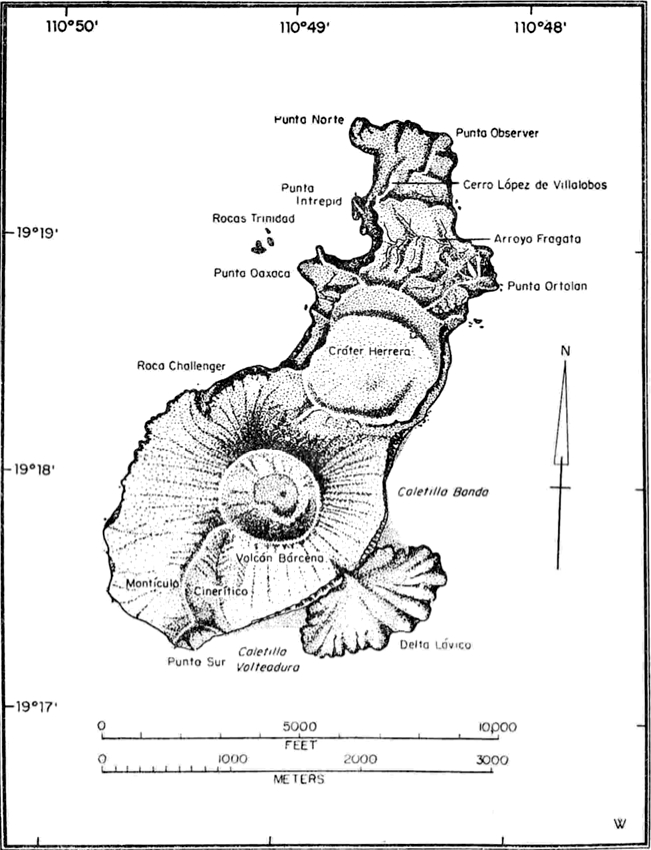
Map of San Benedicto (from Richards, 1959)
With regard of its geological history, Isla San Benedicto can be divided into three regions:
– North: is the oldest, extending beyond the northern shore as a submarine mountain range.
– Center: the northern part of the subaerial island is a region of eroded domes, lava flows and volcanic rocks originating from the Herrera crater to the northern shore which includes La Trinidad and the Challenger Rock. Herrera crater consists of porphyritic trachytic lava. From there and Lopez de Villalobos hill there are also flows of trachybasalts. Cerro López de Villalobos has a particularly complex petrography, it might once have been a volcano in its own right. In the area of Punta Ortalán streams of trachyandesite and trachybasalts can be found – indicating early volcanism.
– South: the youngest part consists mainly of not yet consolidated fragmented rock material from latest eruptions.

Original caption: Furrows on the east flank of Bárcena, September 12, 1952. The sea cliff and ocean are shown in the lower left corner. The light-colored areas represent recent deposits of ash. (Photo: U.S. Navy)
Much thought has been given to the furrowed slopes of the cone. Those furrows have been created after the explosive phase of the eruption which had covered everything evenly in thick ash. Erosion by rain, avalanches of bombs or blocks, tephra avalanches and ash landslides from the crater rim had been suggested causes. It is interesting to follow the considerations that dismissed one cause after the other – arriving at the assumption that tephra avalanches (nuees ardentes, or pyroclastic flows) had created the furrows. Tephra avalanches usually deposit material rather than erode, but avalanche furrowing had also been found on Montagne Pelee. The avalanches tended to descend from the lowest parts of the crater rim and furrowing was most intense below these areas. By September the tephra avalanches were less powerful; instead of rolling and gliding they probably slid and eroded, thereby causing the furrows.

Recent image of the Bárcena cone and the now much more eroded furrows in detail (right). (Author not found)
PROTECTED PARADISE
Today, Isla San Benedicto is a great diving paradise as well as a Biosphere reserve. Visitors would need special permits, limited sportfishing is allowed, and commercial fishing in the area is banned altogether. The Mexican government has given the job of enforcing those laws to the naval base on neighboring Isla Socorro, so there’s hope that the local Fauna will recover in due time and that this beautiful island will stay protected forever.
Here is a nice personal video of a sailing visit to San Benedicto by Vince Radice on YT. If you are not interested in sailing and fishing you can skip the second half:
While the north half of the island is green with vegetation again, “walking on the southern flanks of the island as we did in the video above must be not unlike walking on the moon. There is virtually no sign of life what so ever on the southern beach. The southeastern beach does have a small population of boobies and albatross and green vine like vegetation. […] The islands are not for the faint of heart, that is for sure but those who venture there will reap the rewards of a life time of memories. For a trip to the Island is truly a trip back in time.“ (from World’s Aquarium)
~~~
Disclaimer: I am not a scientist, all information in this (and any of my other posts) is gleaned from the www and/or from books I have read, so hopefully from people who do get things right! 🙂 If you find something not quite right, or if you can add some more interesting stuff, please leave a comment.
Enjoy! – GRANYIA
SOURCES & FURTHER READING
– GVP, Bárcena
– Острова Ревилья-Хихедо. “Горячая точка” Сокорро ( Projects FEB RAS, in Russian)
– Prolonged history of silicic peralcaline volcanism […] Eastern Pacific (1996, PDF)
– The Electronic Volcano
– Rock Stars: Howel Williams (PDF)
– Bárcena Volcano, 1952: a 60-year report on the repopulation […] (2014)
– Geology of the islas revillagigedo, mexico. 1 (1959, paywalled)
– plate-tectonic.narod.ru
– Geology of the islas revillagigedo, mexico. 2 (1966, text only)
– La Jornada Ecológica article about Archipiélago de Revillagigedo (PDF, in Spanish)
– The Humboldt Digital Library


And Volcan Colima had a big explosion this morning (00:28 l.t.) with lots of incandescent material thrown out and an ash column of over 4000m.
LikeLike
Bogoslof is on RED again, eruption column to
3110.5 km. Strange signal this time, not as pronounced as usual but rather a long buildup (MSW seismogram):LikeLike
Actually, one can see the Bogoslof plume, on the FAA webcam “Dutch NDB” West in Dutch Harbor (left), and very probably on the Dutch Haystack NW as well (right), weather permitting, of course. In both images it would be on the left edge. FAA: http://avcams.faa.gov/sitelist.php
Images cropped!
LikeLike
AVO: A satellite image from 13:26 AKST (22:26 UTC), just after this event, showed a dark ash cloud just northeast of Bogoslof. This cloud was darker in color, and presumably more ash-rich, than others we have seen in the eruptive sequence, which began in mid-December 2016. This image also suggests the presence of very hot material (lava) at the surface immediately surrounding the vent – the first such observation during this eruption sequence. (Wednesday, January 18, 2017, 6:25 PM AKST (Thursday, January 19, 2017, 03:25 UTC))
LikeLike
Bogoslof ash cloud: Suomi and Terra Modis images w/thermal anomaly (via Worldview)
LikeLike
Nice shadow of the plume as it works its way east. Great find, Granyia. Interesting find on the post. Cheers –
LikeLike
And here’s the article from the local fish wrapper on that eruption. Looks like the ash got as far east as Kodiak as there were a couple flight cancellations. Cheers –
https://www.adn.com/alaska-news/aviation/2017/01/19/another-bogoslof-eruption-sends-ash-over-alaska-peninsula-kodiak-island/
LikeLike
Bogoslof tends to blow holes first and build up land later in the eruption. The extension to the island may be mainly ejecta with a bit of inflation. The central hole will probably be filled in and replaced by a pushed-up cone at the end of the eruption. I was wondering at first whether the island would survive – seems it will do well enough. But the cabin that was more or less at the place of the eruption is gone! Perhaps it was already gone before the eruption – it was old.
LikeLike
Hi Granyia
the fan shaped lava flow is original
Here is the translation.
“Pumice has been seen “swimming” (more correctly floating, NdT) around these islands which are situated on the same parallel as Volcanoes Colima, Jorullo, Popocatepetl, and Orizaba”.
LikeLike
Thanks dfm! That’s funny, Humboldt, being a German, did not know to use a different word for ‘to swim’ – we don’t have one! To float and to swim is the same in German – schwimmen!
So, those pumice evidence that there has been an eruption ~1811 from either Socorro or San Benedicto. Neither are mentioned in the GVP for around that time, not even ‘uncertain’ ones.
LikeLike
What is surprising also was that Humboldt wrote in french. But at the time (1811) Germany was problably part of the Napoleonic empire.
LikeLike
In this case, that wasn’t the reason. One of Humboldts ideas was that science cannot be done single-handedly, that only a network of different disciplines can achieve best results. He found such a network of scientists in Paris, where he lived for 23 years after the return from his expeditions to work out his chronological notes into books of scientific essays. His work has then been printed completely only by a French publisher. He authorised German editions of some of the 30 volumes, and translations into other languages, but the original pages we find on the internet would mostly be from that complete French edition.
LikeLike
Viele danke für die Erklärung Granyia !
LikeLiked by 1 person
Aha! It looks like Bogoslof has indeed started to build something within the new bay: the latest shoreline (yellow, 01/18) looks much different than the green line from two days earlier. I wonder what the big explosion yesterday has produced above sea level, considering that thermal anomalies had been detected!
AVO: “Analysis of shoreline changes at Bogoslof volcano due to eruptive activity. The base image is from 11 January 2017 and the shore lines on 16 and 18 January 2017 are noted by the green and salmon dashed lines, respectively. Note that the 18 January analysis was conducted before the explosive event on that day.”

http://avo.alaska.edu/images/image.php?id=103911
LikeLike
I really look forward to seeing the next photos!
“The presence of an ash cloud has led scientists to speculate that the vent might now be above sea level, but there is no direct evidence. Still, the island is changing shape with every large eruptive event. Thermal data (not pictured) show high temperatures for the first time, a clue that lava might be finding its way to the surface above the water line.”
http://earthobservatory.nasa.gov/IOTD/view.php?id=89476
LikeLike
Volcan Colima has done some strong dome dismantling during the last couple of days:
LikeLike
Changbaishan: A quite precise date for its VEI 7 eruption could be worked out from a fossilized tree trunk buried in PF deposits: Guardian article.
LikeLike
Hello everyone, good post, I still read, just don’t comment as much as I used to (usually the posts are so thorough, there isn’t much to comment on)! Just thought I’d let you guys know I started my own volcano website a few weeks ago. It’s still slightly under construction, but I hope you guys like it and visit me every once in a while 🙂 .
http://big-volcanic.com/
LikeLike
Hi cbus, thanks! Your blog looks good, haven’t read all posts yet but I certainly will, and will keep an eye on it too. Good luck!
LikeLike
If you like it, please feel free to add my website as a resource, would be helpful in trying to launch the site. I’m going to add you guys when i get around to putting together a page / section of good blogs / resources for volcanoes.
LikeLike
AVO has just raised alert for Takawangha volcano to YELLOW/ADVISORY. “An energetic earthquake swarm on Tanaga Island started yesterday, January 23, and is continuing. The earthquakes locate 6 to 7 km ESE of Takawangha Volcano. This activity may be due to brittle failure in the surrounding rock caused by magma movement. AVO is therefore raising the Aviation Color Code to Yellow and Alert Level to Advisory for Takawangha Volcano. No eruptive activity has been detected in satellite data. […] No historical eruptions are known from Takawangha; however, field work shows that recent eruptions have occurred and it is possible that historic eruptions attributed to Tanaga may instead have come from Takawangha.” http://www.avo.alaska.edu/activity/Takawangha.php
Lake-filled crater at Takawangha’s summit. (img: AVO)
LikeLike
Last eruption is believed to be around 1550 (~450 years ago). This is similar to a swarm at Tanaga in 2005. Could be interesting!
In other news, Erta Ale seems to be going haywire at the moment. Significant lava lake overflows and sizable crater collapses.
LikeLike
I somewhat wonder if there would be any way to see an eruption there if it were to occur. The problem with the Aleutians is that they’re so remote, we may not even see a significant eruption were it to occur.
LikeLike
AVO has a webcam on Adak Island pointed west to watch Kanaga volcano. A decent plume should be visible on that, a little left of Kanaga. The cam is not listed on their current webcam page and has been off for months, but it’s working again today. I guess they’re thinking along those lines too. They will have problems to be certain if the plume is coming from Kanaga or Takawangha, though, it’s a long shot so to speak… Otherwise, probably as with Bogoslof, satellites, lightning, pilots’ pireps etc. http://www.avo.alaska.edu/webcam/kanaga.jpg
LikeLike
Bogoslof is still chugging along. Takawangha shows some signs of waking up. That one is interesting in that its recent activity may have been mistakenly attributed to Tanaga. Cheers –
https://www.adn.com/alaska-news/environment/2017/01/24/bogoslof-eruption-sends-ash-cloud-toward-unalaska/
LikeLiked by 1 person
Howdy all – article in Science Daily about Toba. There is a difference in oxygen isotope abundance across individual chunks of ash. This is thought to indicate that something large changed in the magma chamber shortly before the eruption. The guess is that a large amount of surrounding rock was melted which changed the isotope ratios. That rock also contained a large amount of water which then No explanation why a large amount of surrounding rock would suddenly melt, although a good guess would be an injection of a large amount of hot basalt into the magma chamber. Cheers –
https://www.sciencedaily.com/releases/2017/01/170126081631.htm.
LikeLike
It seems Bogoslof island has more than doubled its land surface since the eruption began. I wonder if that is all uplift or if it is already lava built up on top of the previous ground? Could be both, as there have been thermal anomalies.
Development of Bogoslof island until Jan. 24 side by side. AVO: http://tinyurl.com/jfz6tez
LikeLike
Pingback: Islas REVILLAGIGEDO (MX) 2 – SOCORRO VOLCANO | VOLCANO HOTSPOT
Pingback: Recent Volcanic Activity in Baja California |
Pingback: Amazing Socorro Diving - Giant Mantas & Big Animals | Indopacificimages