
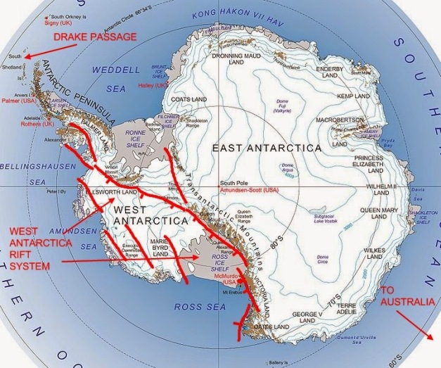
Map of Antarctica with locations named. http://historyoftheearthcalendar.blogspot.com/2014/12/december-13-antarctica-freezes.html
Looking into the previous Gakkel Ridge post got me thinking about volcanoes of Antarctica. The closest we got to this part of the world was a Granyia post about Mount Michael in the South Sandwich Islands. https://volcanohotspot.wordpress.com/2015/10/15/an-elusive-volcano-mount-michael-south-sandwich-islands/
As this is a continent-sized topic, it will take a few posts to do justice to what I found looking at it. This is the first of those posts.
Antarctica is the fifth largest continent, some 14 million km2, the eastern portion covered by nearly two km of ice. The continent is completely surrounded by the Southern Ocean, which isolates it from the warm water currents in the other oceans.

Political map of Antarctica http://www.alamy.com/stock-photo-political-map-of-antarctica-with-the-territory-claims-103376497.html
Politically, Antarctica is a territory over which multiple sovereign powers have agreed to exercise their rights jointly – a condominium. This was set up via the Antarctic Treaty of 1959, signed by 12 nations. Another 38 signatories joined since then. The treaty prohibits military activity, resource development and extraction. It is intended to support scientific research. The continent hosts something in the neighborhood of 4,000 scientific personnel yearly.
Weather on most of the continent is generally cold, dry and windy. If it did not have the ice, it would be formally classified as a desert, one of the driest on the planet. Average precipitation on the coasts is 200 mm / year, with much less in the interior. The coldest temperature ever recorded on earth was measured by satellite in August 2010 at -94.7 C near the tops of mountains in east Antarctica.

Antarctic Plate https://en.wikipedia.org/wiki/Antarctic_Plate
Tectonics
Antarctica began separating from the last supercontinent, Gondwana around 150 MA. Australia, India and Africa were neighboring continents that rifted away from east Antarctica. West Antarctica consisted of a number of microplates / blocks that jostled and rotated during the rifting event and time of travel south to the current location. These blocks and microplates reached their final locations some 110 Ma.
Initial breakup also included plume-generated magmatism which drove rotation and translation of the microplates. The plume head appears to have been in SE Africa. This emplaced large mafic and felsic magmatic provinces along a long linear belt from Australia (Tasmania), Antarctica (Ferrar and Dronning Maud Land) and South Africa (Karoo) provinces. These provinces were emplaced between 182 – 175 Ma and are similar to other continental flood basalt provinces. Total volume emplaced in Antarctica as part of the Ferrar province is in the vicinity of 200,000 km3 of flood basalts. http://www.largeigneousprovinces.org/13apr

Antarctica separation from Gondwana showing large igneous provinces emplaced during the separation. http://www.largeigneousprovinces.org/13apr
The long linear nature of the province is not entirely compatible with current understanding of the operation of a mantle plume. Rather, it appears to be a variation on a hot spot described in one paper as a hot line. Other papers suggest that the magmatism occurred along a number of rifts opening during the continental breakup that intersected, with the magma reaching the surface through lines of weakness. Final suggestion is that the Weddell Sea region was the site of a large Gondwana megaplume causing uplift and a triple junction.
The final stage of breakup completed when Zelandia (New Zealand) rifted from Marie Byrd Land in 84 Ma.
Glaciation began at the end of the Eocene some 38 – 34 Ma. Some researchers believe this was about the time when the Drake Passage between South America and Antarctica opened, allowing the establishment of the current flow around the continent, isolating it from the other oceanic currents.

Antarctica showing East Antarctica craton, microplates / blocks of West Antarctica, and the Kerguelen large igneous province. http://forum.arctic-sea-ice.net/index.php?topic=393.0
Although glaciers started growing at that time, complete coverage like modern Antarctica did not take place until 14 Ma in eastern Antarctica and 6 Ma in western Antarctica. Fossils of tundra vegetation show that the climate in portions of western Antarctica was similar to that of the southern tip of South America as recently as 14 Ma.
The Antarctic Plate is surrounded by spreading centers at the oceanic edges of large neighboring plates. These include the Pacific, Nazca, South American, African and Australian Plates. The smaller Scotia, South Sandwich and Shetland Plates are considered to be part of the Antarctic region. Along with Africa, the Antarctica Plate is the most stable, least mobile of all the tectonic plates. There is no current subduction on the Antarctic continent.

Antarctica circa 100Ma. http://bulletin.geoscienceworld.org/content/112/4/611
The land portion of the continent is divided roughly into East and West Antarctica, with the dividing line being the West Antarctic Rift System. The 3,500 km long Trans Antarctic Mountains marks the majority of the rift. The range has not been folded but is the result of periods of compression, extension, and uplift over the last billion years.
Absolute motion of the entire continent has been small enough that there are no lines of hot spot volcanoes on it. The Kerguelen Plateau, also called the Kerguelen Igneous Province built up in the Indian Ocean over a hot spot over the course of the last 110 Ma. On a fast-moving oceanic plate, it would have presented as a typical hot spot created island chain similar to that of Hawaii.
West Antarctica showing Transantarctic Mountains, West Antarctica Rift System (WARS) and volcanoes http://www.largeigneousprovinces.org/13apr
East Antarctica is located on the Indian Ocean side of the continent. It is a single large craton dating as old as the supercontinent Rodinia over a billion years ago. There are no volcanoes in East Antarctica.
West Antarctica is where all the volcanic action resides. It is constructed of multiple small and micro plates. The northern portion of West Antarctica include fossil tectonic margins, a portion of the extinct Phoenix tectonic plate, which in turn was involved creating the active Shetland Plate and its back-arc spreading ridge.

Three stratovolcanoes erupting in South Sandwich Islands, Sept. 2016. Top is Zavodovski Island, middle is Saunders Island, bottom is Bristol Island. http://strangesounds.org/2016/10/three-active-volcanoes-simultaneously-erupt-antarctica-south-sandwich-island.html
Volcanics
There are extensive outcrops of volcanic rocks in Victoria Land, West Antarctica, and the Antarctic Peninsula. There are isolated outcrops in the central Transantarctic Mountains and on the East Antarctic coast at around the 90 degree E point. Most of the volcanics are young, but due to the remoteness and lack of research, the onset of volcanic activity is poorly dated. The Smithsonian Global Volcanism Program lists 122 volcanoes, maars, and various cones connected to the 41 known volcanoes.
Mount Asphyxia, Zavodovski Islands, South Sandwich Islands. Visokoi Island is in the background. http://www.gettyimages.com/detail/news-photo/south-sandwich-islands-zavodovski-island-view-of-volcano-news-photo/454207492#south-sandwich-islands-zavodovski-island-view-of-volcano-with-visokoi-picture-id454207492
South Sandwich Islands are volcanic islands that close off the Scotia Sea to the east. They are the eastern end of a small plate off the eastern end of the Scotia Plate that plugs the gap between South America and Antarctica called the South Sandwich Plate. The island arc is subduction driven, west of an oceanic trench. The western end of the plate is a spreading center. There are at least nine recently active volcanoes among the islands. Lavas are unusual with basalts and derivatives being the principal rock types. Many of them are comparable to oceanic tholeiites. There was a transition into more calc-alcaline volcanism in some rocks. The oldest dated sample is 4 Ma. Analysis of sea floor magnetic anomalies in the spreading center in the eastern Scotia Sea suggest that volcanism may have begun some 8 Ma. http://earth.geology.yale.edu/~ajs/1975/ajs_275A_1.pdf/45.pdf
In 2011, a British Antarctic Survey group discovered 12 previously unknown submarine volcanoes around the South Sandwich Islands, along with a number of craters of collapsed volcanoes up to 5 km wide.

Deception Island caldera, South Shetland Islands, Antarctic Peninsula. http://www.playbuzz.com/sylviacoogan10/deception-island-quiz
The next major platelet south is the Antarctic Peninsula. It includes the James Ross Island volcanic group. There are at least five eruptive phases in portion of the peninsula dating back to the Jurassic. Initially this was driven by subduction throughout the Jurassic. As the subduction ceased, back arc magmatism shifted to intraplate volcanism most recently. Recent Hawaiian-style lavas overlay breccias. Chemically these are alkali basalts, though they tend to correspond more to olivine tholeiites. The oldest of these date 4.6 Ma, with many dating less than 1 Ma.
Recent volcanism on the NW side of the peninsula is more extensive but less well studied. King George Island has sequences of lavas, pyroclastics and other sediments dating as old as Eocene to Miocene ages (55 – 5 Ma). They are mainly basaltic andesites that tend to tholeiitic. Younger deposits tend to be more alkaline. More recent volcanism seems to take place on the South Shetland Islands than anywhere else. Block tectonics seems to control more recent volcanic eruptions.

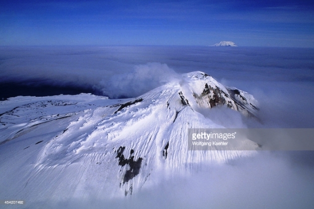
Mount Takahe volcano in Marie Byrd Land http://blog.imagico.de/spring-again/
Marie Byrd Land volcanic province adjoins the Antarctic Peninsula to the south. It has significant alkali basalt underlying tuffs, stratovolcanoes, pyroclastics, and ending with small parasite cones. Volume of the basalts approaches that of a flood basalt, with individual flows hundreds of meters thick. The overlying breccias and pyroclastics are as thick as 2 km. Surface volcanism in this region has mostly stopped in the north, with inactive fumaroles identified. Alignment of the stratovolcanoes suggest a rectangular block surrounded by faults, analogous to the East African Rift System or Iceland. There are 18 large shield volcanoes resident, five of which are sufficiently exposed from the ice cap to appear similar to alkaline oceanic island volcanoes.
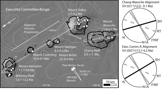
Neogene volcanism, southward progression of new volcanoes in Marie Byrd Land. http://jgs.lyellcollection.org/content/167/2/401.figures-only
Marie Byrd Land is the location of recently active volcanoes below the ice. The volcanoes were identified via seismic observation of deep earthquake activity that correlate with deep magmatic activity. Radar profiles also identified a deep ash layer in the ice overlying the seismic swarm. These observations lead to the conclusion that there is ongoing magmatic activity, indicating volcanism is migrating south along the Executive Committee Range. The activity is unlikely to penetrate the overlying ice sheet, but may be able to generate large volumes of melt water (jokulhlaup) that can modify ice stream flow.

Eruption from Mount Erebus, McMurdo Sound volcanic group. http://www.geoexpro.com/articles/2015/12/the-ross-sea-antarctica
Farthest south is the McMurdo volcanic group. It includes four volcanic provinces – Balleny, Hallett, Melbourne and Erebus. The Balleny and Hallet provinces are distributed along the Balleny Fracture Zone and the Hallett Fracture respectively. Melbourne stratovolcanoes are thought to be associated with north to NW-trending grabens and faults in northern Victoria Land. Erebus is located at the intersection of the Rennick Fault and NE-trending faults along the central Transantarctic Mountains.
Subaerial lavas and pyroclastics have formed significant and active stratovolcanoes. The currently active Erebus is located here. Volcanism here started some 18 Ma. Drill cores in McMurdo Sound have discovered minor volcanic detritus that date as far back as 34 – 40 Ma. It is likely that volcanic centers are buried underneath the East Antarctic Ice Sheet or in sediments within the western Ross Sea.

Balleny Islands, Ross Sea, Antarctica. http://spi-ace-expedition.ch/photo-gallery-balleny-islands/
The Hallett volcanic province includes deposits of breccias, basaltic pillow breccias, covered by lava flows and pyroclastics. Composition tends to trachytic and basaltic.
The Balleny and Scott islands in the Ross Sea have phonolites similar to those found in the Hallett. Chemically, they are undersaturated alkali lavas identical to those on other oceanic islands, suggesting that these are intraplate volcanics. There are also a number of seamounts in the Ross Sea.
The major volcanic provinces may or may not be related to uplift that formed the Transarctic Mountains. One clue is that they are located near a significant change in crust thickness of East Antarctica at 40 km and Western Antarctica (Ross Sea region) at 28 km.

Balleny Islands, Ross Sea, Antarctica http://www.stuff.co.nz/science/79767446/changes-in-the-tilt-of-the-earths-axis-mean-the-antarctic-is-currently-shrinking
Trans Antarctic Mountains (TAM)
The TransAntarctic Mountains are the major mountain range in Antarctica. They stretch some 3,500 km and measure 100 – 300 km in width. Highest point is over 4,500 m. They separate the major geologic portions of Antarctica – the relatively quiet and much older east Antarctic shield, and the much more active west Antarctica.
This range is fairly old, with its uplift triggered by the opening of the West Antarctic Rift starting some 65 Ma. The mountains are generally sedimentary layers on a layer of granites and gneisses. Initial uplift started some 55 Ma.
There is no small amount of disagreement with the notion of a major mountain chain being almost exclusively formed by multiple cycles of uplift along a continental rift. Once the crust starts moving, up the forces of erosion go to work, in this case with the action of glaciers, and the rate of that erosion needs to be less than the rate of uplift for a mountain range to exist. They are the largest example of a non-contractional mountain belt, with no folding or thrust faulting observed.

Transantarctic Mountains http://www.transantarcticmountains.com/blog/page/3/
The range acts as a barrier to the polar ice cap’s flow to the sea across west Antarctica to the sea.
There are several theories about the cause of the uplift. One suggests that the mountain range is an example of a rift-shoulder uplift along a fault line normal parallel to the mountain range. Low density mantle formed under the rift which in turn created uplift on the thick eastern portion of the contient. There are couple variations on this theory.
A competing theory is that the West Antarctic Rift System was a high elevation plateau with thick crust that underwent extension due to plateau collapse.

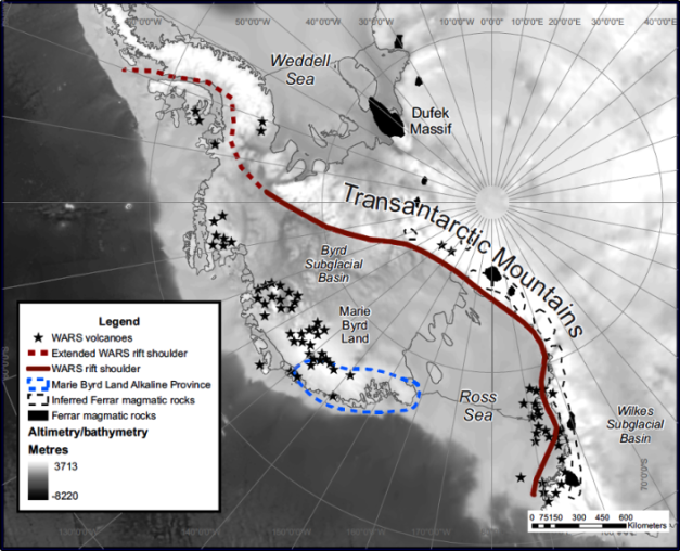
West Antarctica Rift System http://jgs.lyellcollection.org/content/167/2/401.figures-only
West Antarctic Rift System
The final tectonic piece of the puzzle is the West Antarctic Rift System. It extends from the Ross Sea to the base of the Antarctic Peninsula. Its area is comparable with the Basin and Range Province in North America or the East African Rift System. Today, there is a near absence of seismic activity in the rift area, blamed on the thick ice sheet covering most of it.
There is evidence of high temperatures at shallow depths beneath the Ross Sea continental shelf. The same goes for the neighboring Transantarctic Mountains, which is used to explain volcanism, rifting and high elevation of the rift shoulder from Ross Sea to the Ellsworth – Horlick – Whitmore Mountains.
Evolution of the rift looks like it took place in two stages. The initial phase was a distributed extension beginning in the late Cretaceous, where it was broadly distributed across West Antarctica, much like the Basin and Range Province in North America. This shifted in the late Paleogene with the focus in the Victoria land Basin near the boundary of the East Antarctica craton. This transition took place around the same time as volcanic activity and strike-slip faulting in the rising Transantarctic Mountains.
The obvious question is why the change in style. Some have suggested involvement of a mantle plume. Modeling today suggests that the shift only occurs under a limited set of initial boundary conditions, particularly sensitive to pre-rift thermal state of the crust and upper mantle and do not require a mantle plume to change.
Seismic evidence today suggests that the rift is either dormant or very slow moving, with intraplate volcanic activity taking place in nearby Marie Byrd Land.

Marie Byrd Land Executive Range stratovolcanoes http://jgs.lyellcollection.org/content/167/2/401.figures-only Originally published in Smellie & Edwards (2016) Glaciovolcanism on Earth & Mars. CUP (Fig. 2.3, pp. 22)
Conclusions
So, how do we put this all together? The largest portion of Antarctica is East Antarctica, a craton dating back at least a billion years. It is covered with an ice cap kilometers thick. This craton is neighbored by a number of microplates / blocks which form West Antarctica.
Antarctica is home to a pair of large igneous provinces. The first was emplaced around the time it separated from Gondwana 185 – 150 Ma. The second one is the Kerguelen in the Indian Ocean active between 133 – 34 Ma.
During its journey to its current location, the microplates / blocks jostled and rotated into their current position. Today, the plate barely moves, demonstrated by hot spot volcanic activity not forming island chains across the ocean floor.
Recent volcanic activity may be related to rifting and uplift of the West Antarctic Rift System and the Transantarctic Mountains. It is mainly intraplate in nature, with many recent volcanics chemically similar to those of oceanic islands in the Atlantic, Pacific and Indian Oceans.
Now that we have at least an introduction into Antarctica from a tectonic standpoint, next post will start taking a look at the multiple volcanic provinces that make up Antarctica.

Mount Melbourne, Victoria Land https://cs.wikipedia.org/wiki/Mount_Melbourne
Correction
Moved Mount Melbourne from Marie Byrd Land north to its actual location in Victoria Land. Cleaned up captions on photo of Marie Byrd Land stratovolcanoes right before Conclusions.
Additional Information
http://earth.geology.yale.edu/~ajs/1975/ajs_275A_1.pdf/45.pdf
http://www.geology.cwu.edu/facstaff/tim/g501/pdf/Fitzgerald2002.pdf
http://antarctic-plate-tectonics.weebly.com/the-antarctic-region.html
https://en.wikipedia.org/wiki/Geology_of_Antarctica
http://www.mna.unisi.it/Editoria/TAP/TA_pdfs/Volume_01/TA_01_01_115_Antonini.pdf
http://researcharchive.vuw.ac.nz/xmlui/handle/10063/510
http://www-udc.ig.utexas.edu/external/becker/preprints/frbdm08.pdf
http://www.nature.com/ngeo/journal/v6/n12/full/ngeo1992.html
https://link.springer.com/article/10.1007/s00445-013-0726-1
https://link.springer.com/article/10.1007/BF02597798
http://www.tandfonline.com/doi/pdf/10.1080/00288306.1982.10421508
http://antarctic-plate-tectonics.weebly.com/transantarctic-mountains.html
https://www.nap.edu/read/12168/chapter/10#92
http://www.geology.cwu.edu/facstaff/huerta/HuertaWeb/Site/WARS_files/HuertaHarry07.pdf
http://antarctic-plate-tectonics.weebly.com/kerguelen-plateau.html


Great introduction, I did not expect so much tectonic diversity around Antarctica, and not that many volcanoes. I really look forward to your series of posts! Thank you, agimarc!
LikeLike
Thanks for this. You state East Antarctica has no volcano but gaussberg is a volcano.
LikeLiked by 1 person
Howdy mattking1974 –
Missed that one. Thank you for the note. Gaussberg is a very interesting volcano, with some lavas dated at 20 Ma, though the GVP dates the cone at 55,000 years. Volcanics are also interesting – lamproites, which are apparently grouped with Kimberlites and are described as spreading of the mantle plume underlying Kerugulen southward. Cheers-
https://academic.oup.com/petrology/article/43/6/981/1533616/Lamproites-from-Gaussberg-Antarctica-Possible
https://link.springer.com/article/10.1134/S0016702914120106
LikeLike
Awesome post Agimarc. I have often wondered where the volcanism in Antarctica comes from with no apparent subduction around anywhere (apart from the South Sandwich Islands). This post explains it nicely! But how amazing is that about the Transantarctic Mountains being purely the product of rifting! And surviving all that ice! Maybe the flow is not all that extreme due to the low precipitation and, being the high point, there won’t be so much erosion happening… random thoughts. Great piece.
LikeLike
Thanks, Bruce. There is weirdness out there, as the West Antarctica Ice Sheet (WAIS) appears to protect the shield volcanoes of Marie Byrd Land from erosion. Don’t think I understand that a lot, but found it in a couple places. Cheers-
LikeLike
Antarctica is very, dry. So dry, that’s it’s often referred to as a polar desert. This may be a factor in the more limited erosion of many Antarctic volcanoes,
LikeLike
Bruce, the TransAntarctic Mountains are not purely the result of rifting – just as the seafloor of Drake Passage is not purely the result of colossal icebergs carried by ocean currents. Study the size of the Eltanin Tsunami waves, do the math and you’ll begin to realize the forces that carved out the Ross Sea and ultimately resulted in the West Antarctic Ice Sheet – which is more accurately described as a giant ice SHELF – because relatively little land is holding it in place, mostly it’s held there by rapidly melting ice shelves.
LikeLike
Bruce, the subduction zone isn’t on the maps but overlapping tectonic plates are most likely all along the northeastern edge of the TransAntarctic Mountains.
LikeLike
agimarc, very timely post it turns out!
https://www.theguardian.com/world/2017/aug/12/scientists-discover-91-volcanos-antarctica
LikeLike
Howdy Bruce –
They’re talking about the subglacial volcanoes below the West Antarctica Ice Sheet (WAIS) in the West Antarctic Rift System (WARS). The white image with the maroon dots in the article are the known, surface volcanoes. Talk about this a bit in Part 3 which I loaded Friday. Stay tuned. Cheers-
LikeLike
cool. sorry about the hysteria added by the journalists. I was just interested in them finding so many volcanos. Definite parallels to the Rift Valley. The WARS has the East Pacific Rise and its southern extension (too lazy to hunt for the name – wait, no I wasn’t, its the Pacific Antarctic Rise (PAR)) to its north in the same way that the African rift valley has the Atlantic MORB to the west.
There is no subduction to be seen anywhere till you get to Kamchatka/the Aleutians in the case of the WARS and the Andes for the Rift Valley (and the Kermadec Trench to the east)
It always seems counterintuitive to me to have another spreading system on one side of a MOR, but this is the second example after the Rift Valley.
The WARS must be a pretty significant system to create mountains of that size even before glacial erosion is considered, implying that something is driving the rifting other than slab pull, which is what drives mid-ocean ridges. In other words, it looks like a mantle plume must be driving the rifting like the one posited for the Rift Valley in Africa.
Long story short, the one hemisphere from Afar through to the Ross Sea and beyond is spreading and most of the subduction is getting accommodated on the western Pacific rim, maxing out near the triple junction by Kamchatka.
Given the scale of it all, it is not too far-fetched to consider a flood basalt in the WARS (in a geological timeframe of course), which could have massive implications I guess.
LikeLike
then again, as you state.. it now appears to be very slow moving or dormant so maybe all the action is behind is.
LikeLike
ok, now you’ve got me off on a goose chase:
http://onlinelibrary.wiley.com/doi/10.1029/2003GC000657/full
LikeLike
Sorry for all the disjointed thoughts.. the place really is a conundrum. We have an inactive rift with it seems, not a lot happening within it, but a great deal of intraplate volcanism off the rift in Marie Byrd Land, much like seamounts form off an extensional zone, except in this case they are erupting under a piece of crust (another point you already allude to… you see I am just slowly catching up to points you have already covered!) Really looking forward to the next instalments.
LikeLike
Great post! I was really curious about how volcanoes formed here, especially with the new revelations of additional volcanoes found in this area.
LikeLike
CBUS, the seafloor is cracked there because of “lithospheric flexure” which resulted from a huge weight pushing down on the seafloor – that huge force was the water-weight known as the Eltanin Tsunami waves which completely decimated the Antarctic ice and the Antarctic land, Australia, New Zealand, the South Pacific Islands, Hawaii, etc. – the exact date for this cataclysm is found in the historic documents – it wasn’t millions of years ago.
LikeLiked by 1 person
well, 2.51 ± 0.07 million years ago according to Wikipedia. That is one hell of an impact. I’d love to see the modelling of a 200m high tsunami hitting the ice shelf. Hardly bears thinking about. Assuming the tsunami was a series of long-period surges, the ice would have lifted and dropped like a huge raft. And presuming a large section of the ice shelf disintegrated, the isostatic rebound must have been both immense and sudden. Or the ice was too much of a barrier to be lifted, even by such huge waves and they just bounced off. Very intriguing to say the least.
OTOH, you are not going to get volcanism just by cracking the crust (if that is what happened). You will also need a source of hot mantle and/or presence of volatiles to induce melting. My guess is that there are pockets of melt left over from the ancient subduction and/or rifting that causes the intraplate volcanism in Marie Byrd Land
LikeLike
Bruce, if you do the math on the water weight and the resulting force of the tsunami waves, you’ll be able to conceptualize more of the dynamics. Hopefully, you’ll get that aha moment when it all begins to make sense.
LikeLike
I see Bogosloff has started chugging.. might mean a gradual transition away from a transient eruptive state towards dome building
LikeLike
Hello all, I have been on vacation and brought back a new post 😉 :
LikeLike
(The Paper)
LikeLike
Hi. Great site but could you please correctly attribute the images of mine that you have used? I refer to the aerial view of Deception Island and the pair of sat views of the Executive Committee Range. The latter was published in my book: Smellie & Edwards (2016) Glaciovolcanism on Earth & Mars. CUP (Fig. 2.3, pp. 22). Many thanks. John Smellie, University of Leicester.
LikeLiked by 1 person
Thank you for your kind words. Caption updated as requested (hopefully I got the right image). Cheers –
LikeLike
Pingback: Competition Winner – Jade – A Short Scientist
Pingback: Science at the South Pole: Fire and Ice – Never Trust An Atom