
FOR ERUPTION UPDATES CLICK HERE
Gunung Agung, Bali (© Adem D, via tripadviser.de)
A volcano erupting in Indonesia is not something that would normally cause too great a flurry, so what is the hype with Gunung Agung? Naturally, people remember well its last eruption which lasted almost a year, was very explosive and, sadly, claimed ~2000 lives. Additionally, this time after official reports about unrest began, there were also a number of brush fires on the slopes of the volcano, expelling huge clouds of gray smoke – it’s no wonder that people began panicking. Moreover, newspapers all over the world reported that Mt. Gunung was erupting; a German report even “knew” that the plume was “over 10 km high”. That’s what the internet does for you.

Forest fires on G. Agung a few days ago, which caused some people tp believe that the volcano is erupting. Seen from the village of Ban, District Kubu, yesterday on 19/9/2017. (© Istimewa)
After I saw the thermal anomalies on satellite images I did a bit of fact-checking. Wild fires at this time of year, I was told, are common in Indonesia as farmers burn dry rice stalks after the harvest. (Unfortunately, the fires have also destroyed a large area of “protected” forest, seems the protection is not being much enforced by authorities). Also – as of today – the volcano has NOT erupted.

Burning forest on the slope of G. Agung seen on 20 Sept. 2017 from satellite (Sentinel 2, SWIR, based on bands 12, 8A and 4)
BALI, about the ISLAND
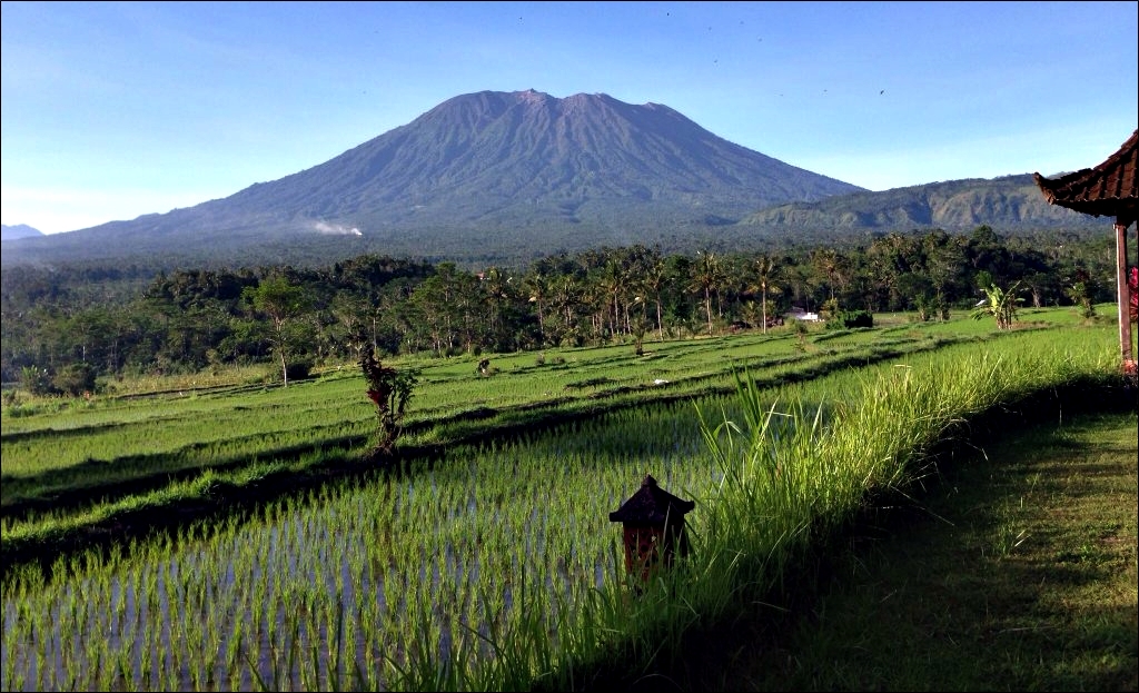
Bali, one of the 13,000 Indonesian islands, is located directly east of Java. About 4.2 Million people live there permanently, but about double that number may be visiting Bali each year. Its size is 145 km long and 95 km wide, big enough to find a safe place during a “normal”-sized eruption.
Mount Agung, Bali, seen from the South. 07/2015 (© Matt, via Wikitravel)
It is a part of the Sunda-Banda volcanic islands arc. Bali is dominantly covered by volcanic rocks, overlying the Tertiary carbonate rocks that outcrop in the southern and western part. The Indo-Australian Plate, which underlies the Indian Ocean to the south of Java, Bali and Lombok, is being subducted beneath the Sunda Plate, a breakaway part of the Eurasian Plate. The latter underlies the islands and neighbouring Sumatra, along the Sunda Trench. It passes under the islands, where friction between the two plates can cause large Earthquakes. As the Indo-Australian Plate sinks further into the Earth it is partially melted and some of the melted material rises through the overlying Sunda Plate as magma, fuelling the volcanoes on the islands.

Structural map of the Lesser Sunda Islands, green circle for Bali added by me. (img. Herman Darman, geoseismic-seasia.blogspot.de/2013/06/)
A string of volcanoes lines the northern part of the island, in West-East axis, along which the western part is oldest, and the eastern part is newest. Stratovolcano Mount Agung is the highest with 3014 m a.s.l. (the generally given hight of 3142 m or so is out of date, as the difference has been blasted off in the 1963 eruption). Bali sits also at the edge of the continental Sunda shelf, just west of the Wallace line, and was at times connected to the neighbouring island of Java, particularly when the sea level was low in the Ice Ages. Today, the two islands are separated by the 2.4 km Bali Strait.
THE VOLCANO

This perspective view shows the major volcanic group of Bali. The conical mountain to the left is Gunung Agung, the highest point on Bali. In the center is the complex structure of Batur volcano, showing a caldera left over from a massive catastrophic eruption about 30,000 years ago. Judging from the total volume of the outer crater and the volcano, that once lay above it, approximately 140 km³ of material must have been produced by this eruption, making it one of the largest known volcanic events on Earth. Batur is still active and has erupted at least 22 times since the 1800’s. (Image/text: NASA/USGS)
G. Agung is on the NE side of Bali. It is part of one of three volcanic centres on the island: the Agung/Seraya volcanic complexes. G. Agung volcano is surrounded by the major calderas of Bratan and Batur to the NW, and the Rinjani-Samalas complex on the island of Lombok to the east. Because of its basaltic andesite lavas Agung can produce highly explosive eruptions – with two VEI 5 eruptions in 120 years this is a volcano to be reckoned with. Although, one should think that it has spent its power now for a longer period of rest.

Gunung Agung, summit cone from the air. (© Bambang Suryobroto, via Wikitravel)
A study of the Late Holocene tephrostratigraphic record showed that Agung has an average eruptive frequency of one (VEI>2-3) eruption per century. About 25 % of all its eruptions are of similar or larger magnitude than the 1963 event, and this includes the previous eruption of 1843 (estimated VEI 5, contrary to previous estimations of VEI 2). The latter represents one of the chemically more evolved products (andesite) erupted at Agung. In general it is thought that Agungs magmas are the product of repeated basaltic intrusions into basaltic-andesitic to andesitic reservoirs, with little compositional variations.

Mount Agung: Erratic lava surface makes for hard trekking conditions half way up the mountain. 07/2015 (© Matt, via Wikitravel)

A solar radiation graph 1958–2008 shows how the radiation is reduced after major volcanic eruptions. Measured on Mauna Loa in Hawaii (here the largest eruption, El Chichón, caused a drop of about 16%).
The abundance of sulfur in a magma is inversely proportional to silica content. Thus, the basaltic-andesite magma of Agung contained more sulfur than the higher silica magma of the historic Krakatau eruption. This high amount of SO2 gas emitted during Agung’s 1963 eruption formed 11-12 million metric tons of H2SO4 aerosols in the stratosphere – which might be linked to a subsequent drop of 0.3°C in average temperatures in the northern hemisphere. The graph (above left) shows how Agung caused the third biggest impact on world climate between 1958 and 2008.

Crater of Gunung Agung. In the crater walls various dikes and sills can be seen, and layers of lava and tephra at the top (before 04/2015, © KatrinSeeTheWorld, via tripadviser.de)

One of the precarious “shoulders” that are the only access paths to the summit of G. Agung. 22.12.2016 (© Cristi Gavrea, via Google Maps)
Scientists modelled the main deep magma source of Agung to be at 18-22 km depth. Also, shallow level magma reservoirs exist at depths between 3 and 7 km (after the 1963 eruption). This trend is found to be characteristic of Sunda arc magma storage systems.
RECENT ACTIVITY

RSAM chart from 01/07 to 13/09/2017 (from PVMBG report)
On Sept. 14, the alert for G. Agung volcano has been raised from Normal to “Waspada” (Attention), the second level of four. It had shown a significant increase in seismicity since the first volcanic earthquakes (EQ) had been recorded in early August. Also a new fumarole emitted steam up to 300 m.

Seismicity of G. Agung from 01/07 to 18/09/2017 (from PVMBG report)
When the numbers of volcanic EQ began to climb into the hundreds per day, the alert level was raised again to “Siaga” (Standby) on Sept. 18. At this time, apparently a small thermal anomaly was also detected within the crater. When an EQ of M 3.1 occured on 18 Sept. the volcanologist in charge reported stronger fumarolic activity and “visible sparks” from the crater.
The latest report by PVMBG (Sept. 22) states that seismicity of G. Agung continues to increase significantly, but no “crater smoke” has been observed.
On Sept. 19 there were 427 VA and 20 VB earthquakes.
On Sept. 20 there were 563 VA and 8 VB earthquakes.
On Sept. 21 there were 592 VA and 82 VB earthquakes.
(VA = Volcanic Earthquake, VB = Shallow Volcanic Earthquake; according to PVMBG)
There is an access restriction order in place for a radius of 9 km around the volcano, extending to 12 km in areas N, SE and SSW of it. Over 11 000 people of the ~ 50 000 who live in the restriction zones have already evacuated to temporary shelters. Local sources say, though, that farmers still go back daily to tend to their farms. (Hazard Map) (Updated 26/09/2017)
THE 1963-64 ERUPTION

Agung erupting on Bali in May 1963, with Besakih Temple in the foreground. The eruption of Mt. Agung caused a great deal of hardship and suffering on Bali during and after 1963.
In 1963 Gunung Agung erupted simultaneously with its neighbour Batur. This was to become one of the most important volcanic events of the 20th century, and the largest and most devastating eruption in Indonesia since the 1883 eruption of Krakatau. On February 18, local residents heard loud explosions and saw clouds rising from the crater of Mount Agung. On February 24, lava began flowing down the northern slope of the mountain, eventually traveling 7 km in the next 20 days. On March 17, the volcano erupted (eventually producing a VEI 5), sending debris up to 10 km into the air and generating massive PFs. On this occasion also the top 300 ft (or more) of the mountain was blown off. According to observations, PFs travelled at an average speed of 60 km per hour and reached up to 13 km to the south and 14 km to the north. The flows devastated numerous villages, killing approximately 1500 people.

After the eruption of Mount Agung on March 26, 1963, most of the cabins have been destroyed in this village. In an eruption on March 17 the volcano had sent debris into the air and generated massive pyroclastic flows. (© AP Photo)
Lahars caused by heavy rainfall after the eruption killed an additional 200. A second eruption on May 16 led to pyroclastic flows that killed another 200 inhabitants. Much of the agricultural land at the foot of the volcano was destroyed. The final output of volcanic materials was calculated as 0.95 km³ DRE (dense rock equivalent).
“Ancient Balinese texts demand that the most important of Balinese Hindu rituals, the Eka Dasa Rudra, is performed every 100 years to purify our world. Such a ceremony was scheduled at Besakih temple in 1963. In February of that year Mount Agung started to rumble, and high priests argued that this was a bad omen from the Gods and that the wrong date had been scheduled for the ceremony. By this time though President Sukarno had arranged to attend with a group of foreign dignitaries and he ordered that the event must go ahead.
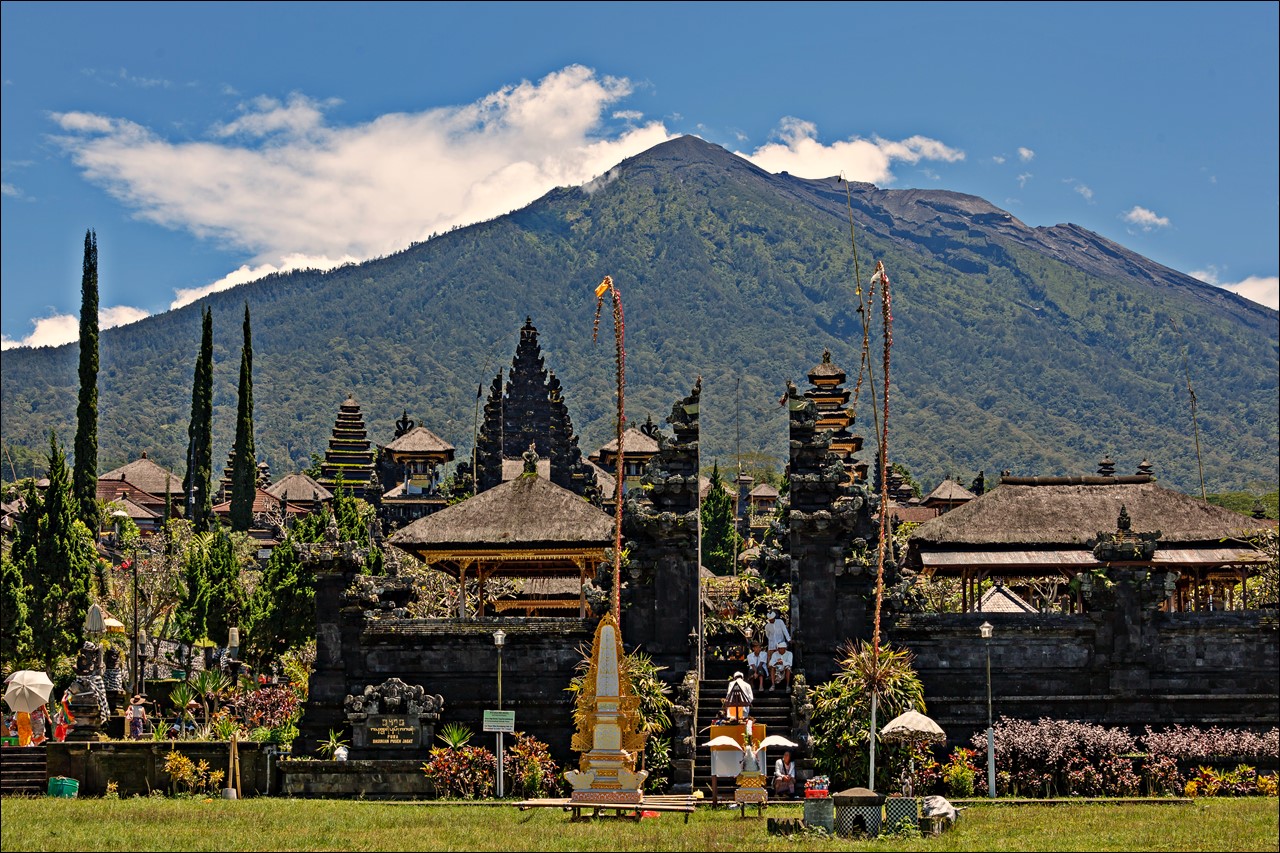
The Balinese believe that Mount Agung is a replica of Mount Meru, the central axis of the universe. One legend holds that the mountain is a fragment of Meru brought to Bali by the first Hindus. The most important temple on Bali, Pura Besakih, is located high on the slopes of Gunung Agung. (© CEphoto, Uwe Aranas, via Wikimedia).
On March 8th the mountain was in a full pre-eruption phase and on March 18th it blew with such force that the top 100 metres or more was blasted away. Lava spewed over much of eastern Bali, a devastating gas cloud swept across villages and ash destroyed all crops. Up to 2,000 people are thought to have died and tens of thousands of homes were destroyed. Quite remarkably, the mother temple of Besakih perched high on the slopes of the mountain was relatively untouched by this event, fuelling the local spiritual reasoning for the eruption. Further, many Balinese argued that this eruption was a portent of dreadful things to come and felt vindicated when the whole nation was plunged into civil crisis in 1965. – The cleansing rituals from the 1963 ceremonies were finally finished at Besakih in 1979.“
The eruption ended in January 1964, leaving a newly shaped crater of 500m diameter and 200m deep.
Video: When G. Agung erupted in 1963, not only the caretaker of Agung refused to evacuate, even almost all adult males from some villages “welcomed” the spill of Agung’s lava kneeling and praying:
~~~
BESIDES:
The Balinese “compass”
Here, people do not talk of north, south, east and west. They refer instead to kaja, kelod, kangin, and kauh. Wherever you are in Bali the direction facing Mount Agung is kaja and this is the most sacred and pure point on the compass. Generally speaking, if you live in the south, kaja is northeast: if you live in the north, kaja is southeast. The opposite and most impure direction is kelod; that is facing away from Mount Agung and towards the sea. Kangin means facing the rising sun that evokes birth and beginning. Kauh is the direction looking west towards the setting sun, a symbol of ending and death. (from gaiadiscovery.com)
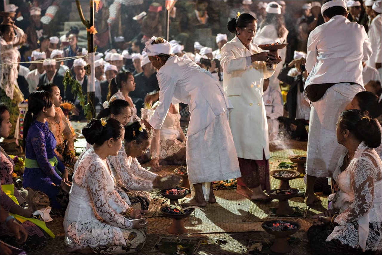
Ceremony in Bali (Img: Earth Observatory Singapore
A living model of sustainability
Another interesting thing is the Balinese irrigation system: “A thousand years ago, rice farmers in Bali created a complex, ritual-based farming system in which “subaks,” self-governing, democratic organizations of farmers, managed the shared use of irrigation water among terraced rice paddies. Subak heads met in sacred temples, stationed along irrigation pathways, to coordinate planting and watering schedules in ways that would ensure an ecologically responsible sharing of resources. Although it has faced challenges, Bali’s ancient water temple system remains largely in place today. Hundreds of water temples are sites of festivals, rituals and religious offerings, thanking the gods for the gift of irrigation water, which flows through canals and tunnels from Bali’s volcanic Lake Batur into numerous rivers and streams and to the jewel-like terraced fields. This system is considered a living model of sustainability.” (from Earth Observatory Singapore, see more images with this post: http://www.earthobservatory.sg/project/bali)
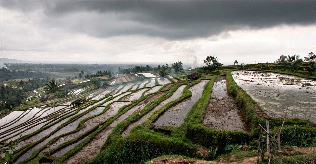
Rice paddies on Bali using a unique irrigation system. (Earth Observatory Singapore)

One of the “shoulders” that flank G. Agung’s crater to the NW and SE. Before 07/2015 (© Gedebalitourprivate, via tripadviser.de)
![Aerial view of G. Agung with the great Batur Caldera visible behind it. [before 04/2012, © Fabien Pollet-Villar, via mapsights.com] (Mapsites.com seems to be a "rescue dump" for images from the closed Panoramio website)](https://volcanohotspot.files.wordpress.com/2017/09/ag08.jpg)
Aerial view of G. Agung with the great Batur Caldera visible behind it. [before 04/2012, © Fabien Pollet-Villar, via mapsights.com] (Mapsites.com seems to be a “rescue dump” for images from the closed Panoramio website)
~~~
Disclaimer: I am not a scientist, all information in this (and any of my other posts) is gleaned from the www and/or from books I have read, so hopefully from people who do get things right! 🙂 If you find something not quite right, or if you can add some more interesting stuff, please leave a comment.
FOR ERUPTION UPDATES CLICK HERE
Enjoy! – GRANYIA
SOURCES & FURTHER READING
– Agung on GVP
– G. Agung (on Badan Geologi’s website)
– Reports (on Badan Geologi’s website)
– A 5000-year record of […] Gunung Agung (2015, paywalled)
– Inflation of Shallow Magma Reservoirs […] by InSAR (2012)
– Geothermal systems […] Bali (PDF, 2015)
– G. Agung on MIROVA (look up “Batur”)
– New Decade Volcano Program #6 (VolcanoCafe, Blog)
– […] Magma Supply System of Agung and […] (PDF, 2014)
– […] Bali’s Mountains and Lakes (Blog)
– Mount Agung, Wikitravel


latest bulletin shows continued high levels of seismicity :
“On September 27, 2017 at 00:00 WITA to 06:00 WITA, recorded 106 times Shallow Volcanic Earthquake (VB), 165 times In Volcanic Earthquake (VA), 27 times Local Tectonic Earthquake (TL).
Recommendation: Communities around G. Agung and climbers / visitors / tourists not to be on, do not climb and do not engage in any activity in the danger zone that is within the G. Agung crater area within a radius of 9 km from the top crater of G. Agung and plus sectoral expansion to the North-Northeast, Southeast and South-Southwest for 12 km.”
I guess that last sentence is an indication they think they eruption might mirror the 1964 eruption.
I see at some other sites people getting excited about the prospect of a caldera forming eruption. I think that is still highly unlikely for the following reasons.
Although the region is dotted with large (and recent) calderas there is an absence of flank collapses, which is astounding, given the height of the edifices.
This suggests to me that the structural components of the volcanoes are relatively firmly welded. At Agung this ties in with the more mafic magmas and despite the explosively (high volatile content) of the magmas, it suggests there are frequent lava flows and probably relatively hot lava flows (particularly if the magmas do not reside in shallow storage very long and are sourced almost directly from the mantle).
Over time, the shallow chambers will evolve and due to the height of the edifice intrusions will find it increasingly difficult to reach the surface. Volatiles will build up in the shallow storage chambers and due to crystal fractionation, the magmas will get more silica rich.. Only when this phase is reached and the shallow magma storage chamber has reached the requisite size will there be any likelihood of a large caldera forming eruption.
At Agung it appears the system is relatively open from the mantle source through to the vent so I doubt that the shallow magma chamber is anywhere near being primed for such a large event. The one caveat to this is that I haven’t found any information about the size of the shallow chamber (which is tricky to assess at the best of times)
Another observation: Although G. Agung is a huge mountain, proto-Batur next to it must have been about one order of magnitude bigger (by volume) in other words, Agung could still grow a lot yet. Moreover, if you consider how many small eruptions it takes for something to grow that big, you can get an idea of the relative likelihoods of a small to moderate (up to VEI 5) eruption to a VEI 7 eruption.
So my bet (and this is all pretty wild speculation) is for an eruption of between VEI 3 to VEI 5 up to but not exceeding the size of the 1964 eruption.
and while I am here: hat tip to Mike Ross for his voice of reason.
LikeLike
With so many volcanoes on Bali (3-5), and esp. active Batur near Agung, I thought there might be a number of shallow magma chambers beneath them, perhaps stacked in hight as well. Agung already erupted (more evolved) Andesite in ’63, and researchers think it was intruded during the eruption by basalt. The andesite could have come from a batch in longer repose, and, by pressure release, newer magma from a lower chamber followed up? They expect a smaller eruption this time because they don’t expect further andesite to erupt.
This paper has been tweeted as open access, but it is not open for me. Got it on sci-hub, though. https://link.springer.com/article/10.1007/s00445-012-0615-z?no-access=true
Where did Mike say what?
LikeLike
btw there was a strong and unusual signal at JAGI about 30 min ago (0815 UTC). Not your usual tectonic P/S double cone wave but more spherical. Wonder what that was!
LikeLike
Googled JAGI, found (Korean) for Jagiya: honey, sweetie, love, darling. 😀 So, where is JAGI?
LikeLike
The Government of Vanuatu has ordered complete evacuation of all (more than 11 000) residents of Ambae island yesterday. Most of them are going to the island of Pentecost, but more possible evac. centers are considered.
A few bold young people ventured to the summit of Mt Lombenben for a better view of erupting Manaro volcano. They noted that they saw some “fire” and that the second lake (nearere to them) had changed water color. Video by by N. G. Tambeana:
https://twitter.com/i/videos/tweet/913553878070706176
Sat. img of Manaro volcano via NASA-worldview today shows constant heat signature again. I wonder if the lake is dry now and if there might be a lava lake?
LikeLike
G. Agung update: No eruption yet. Over 100 000 evacuated. A video of the crater interior published on 29/9 by a travel agency (https://www.youtube.com/watch?v=pL5qyyfuFNc) shows five or six new fumaroles in the NE (?) corner:
LikeLike
G. Agung update: Earthquakes fluctuating in number but increase in magnitude. – New fumaroles, plus a new area of emissions in the center of the crater. – Ongoing inflation.
Updates are now available in English:
https://magma.vsi.esdm.go.id/press/view.php?id=98
LikeLike
Reports overview page (press releases):
https://magma.vsi.esdm.go.id/press/
LikeLike
That’s an excellent summary. Great they are now issuing them in English.
LikeLike
Hi Graniya, only just saw your replies above..
here’s the link to JAGI (seems to be the closest online plot but is unfortunately a long way away from the mountain. I am not sure it will pick up harmonic tremor from that distance):
http://geofon.gfz-potsdam.de/waveform/liveseis.php?station=JAGI
Looks like seismicity is increasing this morning (report from Oct. 1 run through giggle):
“-29 September 2017 recorded 198 times Shallow Volcanic Earthquake (VB), 565 times Inner Volcanic Earthquake (VA), 26 times Local Tectonic Earthquake (TL).
-30 September 2017 recorded 252 times Shallow Volcanic Earthquake (VB), 542 times Volcanic Earthquake In (VA), 4 times Local Tectonic Earthquake (TL).
-01 October 2017 (00: 00-06: 00 WITA), recorded 100 times of shallow volcanic earthquake (VB), 180 times of volcanic earthquake (VA), 7 times local tectonic earthquake (TL) and felt 1 times.
Recommendation:
Communities around G. Agung and climbers / visitors / travelers to avoid, do not climb and do not engage in any activity in the danger zone of deep within the G. Agung crater within a radius of 9 km from the summit crater of G. Agung and added expansion sectoral to the North-Northeast, Southeast and South-Southwest for 12 km.”
LikeLike
yippee! a seismogram! no HT yet. But a lot of brittle fracture… ties in nicely with the “pyroclastic veins” that they talked of at Unzen. I get this image of the volcanic gases decomposing the rock in the conduit above the magma column to a point where it is so weak that the magma can make the final push to the surface.. Big question will be how gaseous that first charge will be (the “throat-clearing phase”). Will it be an effusive lava flow or a vulcanian explosion?
LikeLike
I was wondering if those little bursts were the brittle fractures people talked about. Some look like they may have gases pushing through after them?
LikeLiked by 1 person
Hi Clive, that is the precisely the question I have been pondering for years and still have not found any definitive answer: how can you distinguish from a seismic signal if it involves just gas or if it involves the movement of fluid magma? Both harmonic tremor and tornillos are attributed to the movement of “gas or fluid” which implies they could be caused by magma, exsolving gas or geothermal activity. How can you tell the difference? As of the time of writing this, there has been a noticeable uptick in seismic activity at Agung over the last two hours (0300 -0500 UTC) but I can’t see any tornillos or HT.
We know Agung erupts more mafic magmas (basalt to andesite)
The less silica in the magma the less gas can be contained in solution. (btw CO2 exsolves at much greater depth than H2O)
The magmas at Agung are quite explosive hence they contain a relatively high concentration of volatiles. I couldn’t find any data on this but let’s guess at 4%. This would mean H2O starts exsolving at a depth of roughly 5km (although the initial bubbles at these depths will be tiny due to the confining pressure).
Agungs shallow magma storage is thought to be at roughly 5 km depth.
We are seeing a shipload of brittle fracture going on.
Brittle fracture is attributed to pyroclastic veins of gas/ash fracturing the host rock in advance of ascending magma. But we haven’t seen any sign in the signal yet of the magma directly.
So what do we make of all this?
My guess is that the magma column is ascending from the shallow storage but is still at some depth between the shallow storage and the crater.
There seems to be a LOT of fracturing going on which suggests there is quite a lot of gas involved, implying that the body of magma is not just of marginal volume. The big questions are if magma can exploit one of these pyroclastic veins feeding the fumaroles and if so when, and how rapidly. Looking at other eruptions over the past ten years or so I have been watching this stuff, sustained HT sometimes only started immediately before the eruption. And according to Erik there is a positive correlation between the number of tornillos and the volume of the eruption.
So while an eruption is looking increasingly likely, I think we still have to see HT and/or tornillos before getting too excited. However, once we do see these the eruption might only be hours away.
Disclaimer.. I could be completely wrong on all of this!
LikeLiked by 1 person
actually, I will retract what I said about there not being any tornillos.. in the last hour or two some of those signals have durations of up to 80 seconds.. that could qualify them as tornillos. I at first just thought they were largish volcanic/tectonic quakes. Not an expert on this, so don’t quote me on this! But 80 seconds is quite long
LikeLike
still not sure on this.. probably just larger VT events.
LikeLike
https://magma.vsi.esdm.go.id/live/seismogram/
LikeLike
good article on the evacuation at Ambae in the Guardian:
https://www.theguardian.com/world/2017/oct/02/planes-ships-barges-the-diy-evacuation-of-vanuatu-volcano-island
LikeLike
I wonder why they think the eruption at Aoba/Manaro is going to ramp up so much? You can see lava in the video so it obviously already is erupting. They must be expecting a large new pulse of magma or maybe they are worried about a phreatomagmatic eruption and accompanying base surge.
LikeLike
S. Cronin, one of the expert Volcanologists on Ambae matters, said he did not expect a very damaging eruption, a few days ago. Today, Vanuatu scientists thought that the volcano has “stabilized”.
LikeLike
Bruce, it seems you are quite right about the magma source below Agung not being small:
“Devy Kamil, the head of a sub-section of PVMBG, said on Sunday, October 1, 2017: “The magma is not scattered, but is a single mass of magma that’s on the move. The magma is seeking cracks and weaknesses through which to escape to above the surface.”
News article on an assesment of the magma storage underneath Agung. Doesn’t sound hopeful for a quiet eruption 😦
http://www.balidiscovery.com/messages/message.asp?Id=17446
LikeLike
ha 😉 though 15,000,000 cubic meters is only 0.15 cubic km so we are not talking about a huge volume. I wonder if they calculated that by inferring from the inflation using the Mogi formula like Geolurking does.. if so they induced a spherical body with a radius of 150 m (diameter 300m) .. though I am not sure this actually tells us much.
LikeLike
well, I guess it tells us the intrusion is not that big after all though I have my doubts about the direct correlation of inflation to the ensuing size of an eruption. I am not sure if that data warrants the strong language of the article. An intrusion of that size is not likely to be a “huge” eruption or “extraordinary” but I guess you never know.
LikeLike
15 Mill. m³ is even only 0.015 km³… but, “Our estimates and analysis indicate that there is, in fact, more than 15 million cubic meters of magma that is moving below the surface. That amount is limited to only that causing the earth tremors… The estimate of the magma’s volume is extrapolated by converting the magnitude of the tectonic earthquakes emanating from Mount Agung, permitting the PVMBG to calculate the pressure and size of the deposit of subterranean magma” (emphasis by me).
So they just account for the already risen (“moving”) amount of magma that is causing the tremors within the mountain – and perhaps will be erupted with the first explosions. Certainly not the entire reservoir below. (1963 had erupted 0.95 km³ DRE)
LikeLike
Well, they are walking on the small edge between mollification and justification, the most difficult task.
LikeLike
ha, nicely put. It is hard to know what the 0.015 km³ is actually referring to when they say “magma on the move” All I can think of is extrapolating from the measured inflation of the edifice. I don’t know of any model that calculates magma volumes from the magnitude of seismic activity.. do you?
LikeLike
No, I do not, but my knowledge is not a yardstick for anything… esp. not for anything mathematical, haha. But I guess it could be possible to extrapolate something from the cumulative energy of quakes (which should be calculated constantly anyway) for a given time frame, figuring in rock density, temp. and pressure… You’d still have to account for amount of gas content which would be crucial… In such cases I’d rather become religious and *believe* what experts say. 🙂
LikeLike
Nothing wrong with a bit of faith in the experts! … certainly beats flying by the seat of your pants like I do
(not sure if this reply is going to appear at the right place!)
LikeLiked by 1 person
am cate from kenya coming from nakuru london where there is menengai crater……..so on the night of 1st december i dreamt of eruption taking place on menengai ……….i was so scared coz i new the dream was real and it had to take place or was taking place somewhere……so i pleaded with Jesus christ our king in the dream not to let it happen………
so still on the same dream i found myself having travelled in a foreign country which i didnt recognize it and i found myself asking people starting with the president why they had foreseken Christ……….
what i know about myself i do see revelations in dreams……..
so next day i was shocked to see that in deed somewhere in this world volcanic eruption was taking place…….so i just had to post this coz i was shown and i had to pass it out…..if its related to your country u will know that Jesus is talking to u people……..
LikeLike
Hi Cate, thank you for your comment! It inspired me to write an entire post on the Menengai Crater volcano, I hope you like it!
LikeLike