
Mageik and Trident are a pair of stratovolcanoes either side of Katmai Pass at the head of the Valley of Ten Thousand Smokes in Katmai, Alaska. They form part of the Katmai cluster of volcanoes. We have previously discussed volcanoes near and around the Katmai cluster in an introduction to Katmai in 2014, and neighboring Martin / Alagogshak in 2022. Somewhere along the line, we will take a look at the remaining volcanoes of the cluster, Griggs, Katmai and Novarupta.
Volcanoes are very closely spaced along this portion of the volcanic front, the most closely spaced on the Alaska Peninsula. Mageik is only 7 km NE from previously discussed Martin. Trident is another 10 km farther NE. As such, I will be repeating much of what I wrote previously about the general area and tectonics in this post.
This portion of the volcanic front is permanently glaciated, which makes analysis of what is going on in the craters of the volcanoes problematic. Like Martin, Mageik has a small phreatic crater with vigorous fumarolic activity. Reports of historical activity have been disputed in a pair of papers around 1999.
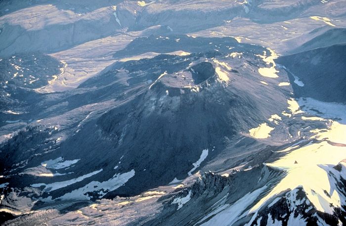
Trident recently erupted, building a dome in 1953, producing a series of thick andesitic lava flows 1953 – 1968, and building a new summit cone. Periodic explosions continued through 1974.
The Alaska Volcano Observatory monitors multiple volcanoes in the Katmai group with both webicorders and webcams. Martin’s webicorder can be found here. The Katmai webicorder can be found here. The Katmai webcam is not currently operating. There are numerous other seismographs in the Katmai region. Though they are not formal webicorders, their output can best be accessed via the AVO interactive Webicorder map or on any of the Katmai volcanoes home page, zooming in, and clicking on any of the listed seismic stations listed from SW – NE: ACH, KABU, KBM, KCE, KCG, KAKN.
The Katmai – Novarupta region is remote, with less than 1,000 living within 100 km of the region. Mageik and Trident are roughly 445 km SW Anchorage. The Katmai volcanic group is surrounded by Katmai National Park & Preserve. It was established in 1918 following the devastation of the 1912 Katmai – Novarupta eruption and creation of the Valley of Ten Thousand Smokes. Today, it is frequented by visitors and guides. The region has over 9,000 years of human habitation.
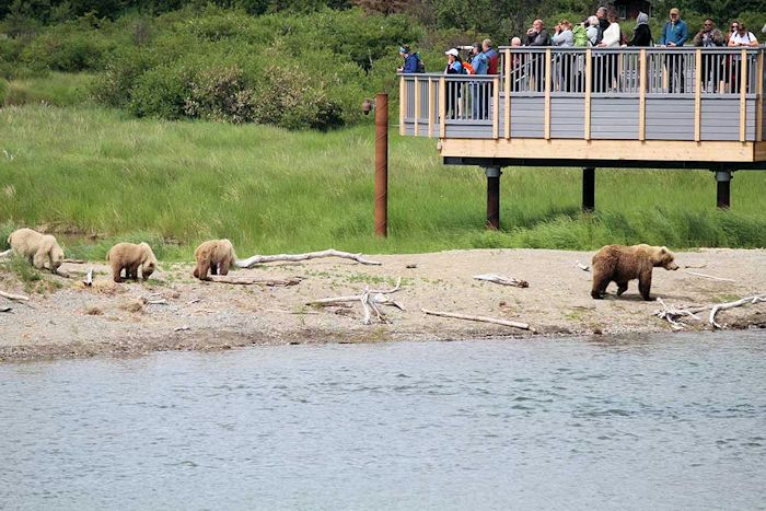
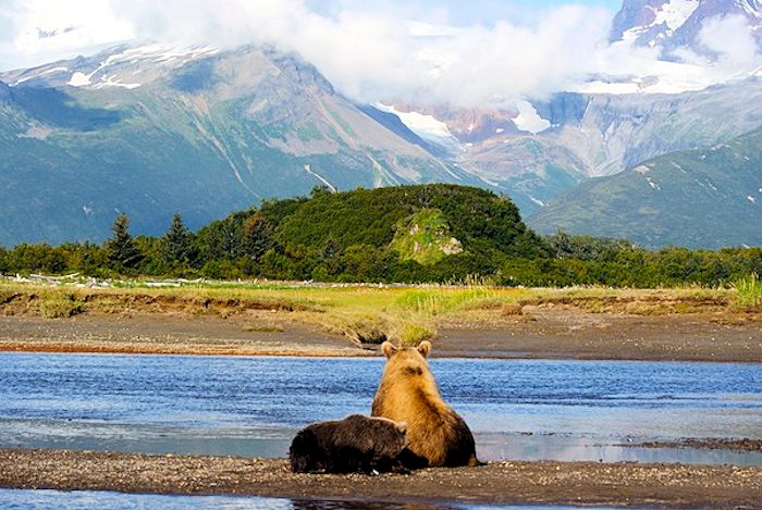
It also has significant wildlife, particularly salmon and brown bears. Bear viewing present and remote is extremely popular, with Brooks Camp being the most popular destination. Occasionally, visitors choose poorly and become one with the bear as self-described Bear Whisperer Timothy Treadwell and his girlfriend did in 2003. The attack was fully captured on audio, some of which was not released to the public due to its graphic nature. Treadwell used to video his interactions with bears.
Weather in Katmai is generally wet and cool, spring summer to fall with temperatures ranging from freezing to as high as 27° C. Winters are even more variable than summers, ranging from -37° – +10° C. Most ponds and lakes are frozen by mid to late fall. Snow covers higher elevations of the park until late May – early June. Strong winds and storms are more common along the coast than in the interior of the park. Visitors are advised to bring high quality waterproof clothing, layer up, and keep heads and hands covered.
Region
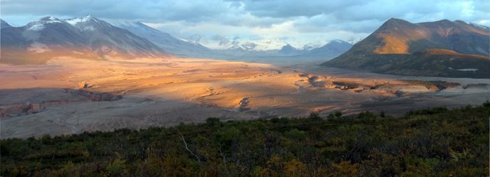
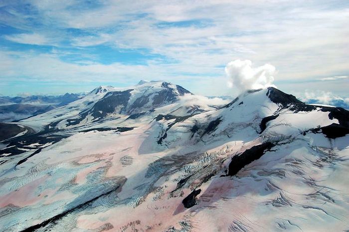
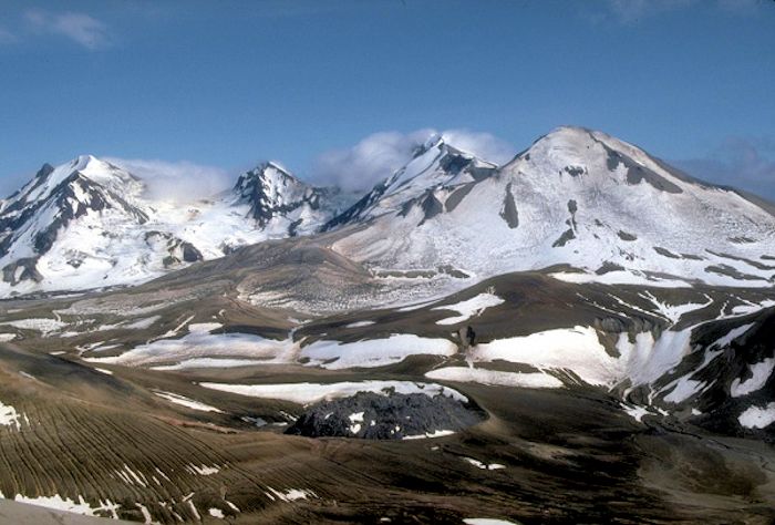
The heart of Katmai is a cluster of five stratovolcano groups, a 25 km long line of volcanoes along the Alaska Peninsula. It also includes the 1912 Novarupta vent, a massive ignimbrite flow in the Valley of Ten Thousand Smokes, and the caldera lake occupying Mount Katmai. The magma plumbing system under the cluster is complex, as demonstrated in the 1912 eruption, where the source of the Plinian eruption and ignimbrite was separated from the newly formed Katmai caldera by 10.5 km. Stratovolcanoes in this cluster from S to N include Alagogshak, Martin, Mageik, Trident, Katmai and Snowy Mountain. The Novarupta vent is not a stratovolcano, though part of the group. Novarupta and Griggs are located off axis, 5 and 12 km respectively to the west of the volcanic front. Novarupta is located at the foot of Trident. The volcanic front is permanently glaciated, with several crater lakes and active fumaroles.
All of these with the exception of Alagogshak have erupted over the last 6,000 years, with at least 15 post glacial eruptive episodes. All of these episodes lasted days to years, likely produced ash and lavas. There are also flank collapses and debris flows from the stratovolcanoes. The region is defined by the historic 1912 eruption which created a new caldera at Katmai volcano, a dome-filled vent at Novarupta, and a massive ignimbrite filling the Valley of Ten Thousand Smokes. The eruption also triggered flank collapse landslides from Mageik to the SE, on the other side of the volcano from the Novarupta vent.
Griggs, Katmai, Trident and Mageik partly surround the head of the Valley of Ten Thousand Smokes, which stretches to the west from the volcanic front. Vigorous fumaroles on Martin, Mageik, Trident I and Griggs have been active since they were first photographed in 1913 – 1917. None of these volcanoes erupted during that time. While the plumes eject mostly steam, they also contain CO2, H2S, and HCl, indicating a magmatic component powering them. Fumaroles at the three vents that erupted in the 20th Century (Trident, Novarupta, Katmai) have declined in output.
Mageik
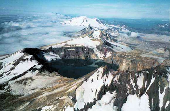
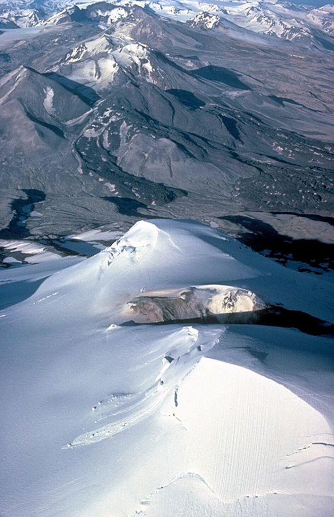
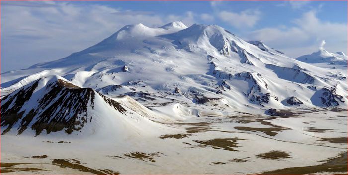
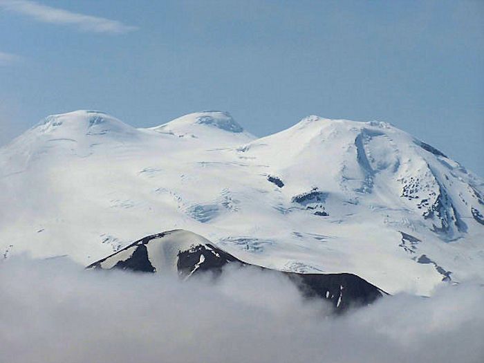
Mageik is an andesite – dacite stratovolcano topping out at 2,165 m. It has the largest footprint of all Katmai volcanoes at 80 km2 and the largest volume at 30 km3. The volcano is constructed from four separate volcanic edifices, coalescing around a central summit. The larger edifice is topped with four ice-covered summits. Three of these have small, fragmented summit cones with ice-filled craters. The fourth, and highest Central Summit is topped with a dacite dome. The structure straddles the volcanic front and products generally flow SE toward the Pacific slope and Shelikof Strait or NW toward Bristol Bay and the Naknek Lake system.
Each of Mageik’s summits is a discrete eruptive center, the source of numerous andesitic and dacitic lava flows. Many of these are 50 – 200 m thick. About 30% of Mageik is covered by glacial ice. The four summits are 80% ice covered.
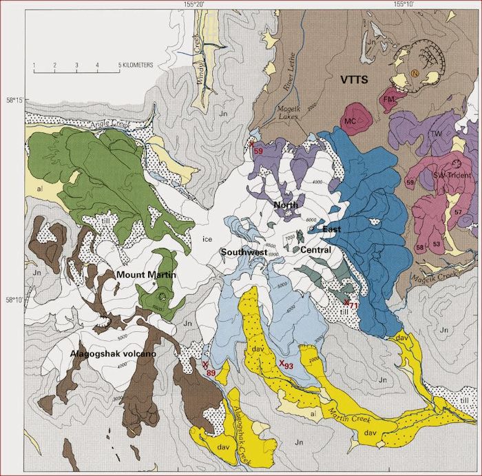
Three of the four overlapping Mageik edifices are heavily eroded by glacial ice. The oldest lavas from Southwest Summit are as old as 93 ka. The 25 or so exposed lava flows from that vent likely erupted in several episodes with a total volume of 9 – 10 km3. They are all older than the set of lava flows from Central Summit, the oldest dated at 71 ka. These are around 4 km3. The North Summit vent started erupting 59 ka, producing 1.5 km3. Each of the three older Mageik summits were quickly built in a 10 – 20 ka window. The construction is similar to that of Southwest Trident, short episodes of lava eruptions and small cone building. The youngest East Summit erupted around 5 km3.
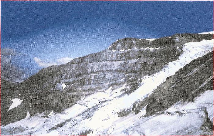
Eruptions from the Southwest Summit built the southwestern half of the volcano. It is the oldest and most glacially eroded. It is also has the largest volume of the four eruptive centers. Lava flows from the Southwest Summit are divided into four groups. The SSE is a stack of at least seven andesite and dacite lava flows at least 350 m thick. The two thickest flows are about 150 m thick at their eroded ends. There is a stack of eight andesite and dacite lava flows, each 30 – 100 m thick that built a south trending ridge separating the headwaters of the Alagogshak and Martin Creeks. Maximum exposed thickness of this stack is 275 m facing Martin Creek. There is a single andesite flow northward toward Angle Creek, 150 m at the eroded end. Finally, there is a stack of andesite – dacite lava flows exposed as 600 m cliffs on the NW buttress. There is a major cirque headwall just SW of the summit cone with severely hydrothermally altered rock. This is the source a debris avalanche deposit down Martin Creek for 16 km.
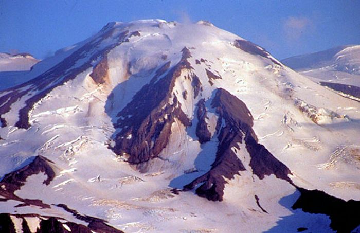
The Central Summit is a 1 km wide dome rising 180 – 250 m above adjacent saddles. It is the highest point of the volcano. Two faces are ice covered. The east face is exposed by the fumarole active crater at its base. Lava flows radiating from the dome are exposed as far as 4 km down the slope. The Central Summit is estimated to be only around 15% of the surface area of Mageik, though its products have been partly covered by eruptive products of the younger North and East Summits.
The North Summit rises only 100 m above the saddle connecting it to neighboring summits. There is an ice-filled crater 300 m wide and a 1 km long lava flow on the NW slope. The crater rim is highly altered by the hydrothermal system. Lava flows are not and extend to the northern base of the edifice where they are 100 – 200 m thick.
The newest part of Mageik is East Summit. It was built during the last 10 ka. There are a dozen leveed lava flows down the flanks toward Katmai Pass and Mageik Creek. These were erupted during 2 – 4 eruptive episodes, with a total volume of 5 – 6km3. The youngest of these lavas is chemically similar to a 4,000-year-old pumice fall deposit, likely erupted in the same episode. This means the entire edifice was built 10 – 4 ka, giving an average post glacial eruption rate around 0.5 km3 / 1,000 years released in 2 – 4 episodes. None of the lava flows have been glacially scoured on the lower flanks.
Hydrothermal System
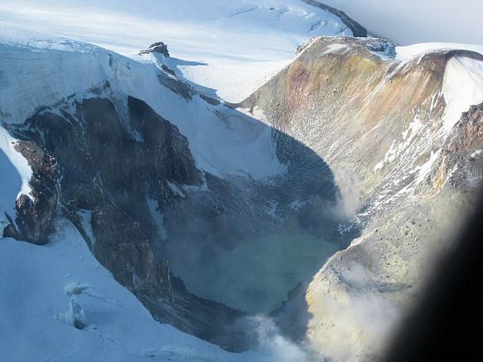
Mageik’s crater is 100 deep, 450 x 400 m wide. It holds a lake 125 m wide. The water is acidic, as hot as 72°C, and continually roiling. The waves built a fringe of yellow, frothy sulfur along the shoreline. There are several fumaroles on the shoreline S and NE of the lake and beneath the lake. Some of these are superheated as hot as 172°C in 1979. There are loose blocks which appear to be excavated explosively from the crater found as far as East Summit, 600 m NE of the crater. Hydrothermal alteration of the crater walls is only moderate, indicating the crater is relatively new. There is no juvenile material, suggesting recent activity was phreatic.
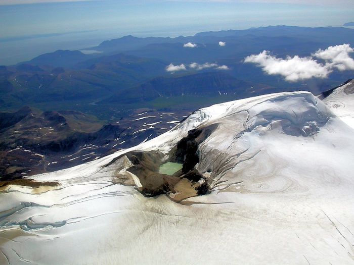
Plumes from this crater are generally visible from a distance, though rarely extend more than a kilometer above the crater. These plumes are rarely as large as steam and gas plumes from neighboring Mount Martin. The Mageik and Martin plumes are the largest hydrogen sulfide rich plumes in the Katmai district.
Mageik’s conspicuous fumarole plume has triggered multiple eruption reports in the 20th Century. Not a one of them was an actual eruption. The only recent ash and tephras on the lower flanks of Mageik were from Novarupta in 1912 and Trident in 1953. Floating pumice attributed to a 1936 eruption of Mageik came from the 1912 Novarupta eruption. That pumice still lines the beaches of Skelikof Strait and is remobilized by bad weather.
Mageik Debris Avalanches
There are at least three Holocene debris avalanches from the south slopes of Mageik down the Martin Creek watershed. The oldest and largest broke loose from hydrothermally altered face of Southwest Summit and flowed down the west fork for at least 16 km. It dates around 3,400 years old. It is hummocky orange and yellow deposit that fills much of Martin Creek. It is at least 70 m thick at the lower end with hummocks 5 – 15 m high. The flow covers at least 15 km2, with a total volume around 0.35 km3.
The smallest of the three deposits flowed down the east fork of Martin Creek. It covers just under 3 km2 and is 15 – 25 m thick at the lower end. It is of intermediate age and consists almost entirely of fresh andesite blocks and scorias. The blocks are as large as 5 m. Its volume is estimated at 0.025 km3, but source and lower end are both covered by younger lava flows from East Summit.
The youngest debris flow was triggered during the 1912 eruption. It is covered by most of the 1912 ash fall, though not by the earliest layers, indicating it cut loose sometime after the eruption started. The deposit extends 6 km from its headwall. The debris is black, glassy dacitie lava blocks from lava flow failure on the lower south flank of Mageik. The deposit covers 6 km2 with a total volume no larger than 0.1 km3. It also partly covers the oldest debris avalanche deposit.
There are likely much smaller avalanches of altered debris from the steep east face of the East Summit, though they have been obscured by ice, snow and the 1912 flow.
InSAR measured uplift 1995 – 2010 along the ridge between Martin – Mageik – Trident. Coverage was not continuous, missing 2000 – 2004. Total uplift was just under 3 cm/yr. At the same time, there was subsidence at neighboring Novarupta.
Trident
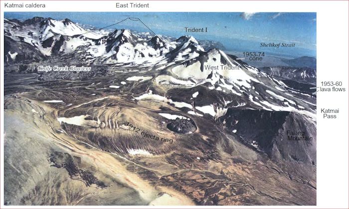
Trident is a 1,708 m andesitic stratovolcano dome complex along the volcanic front at Katmai. It is constructed of four overlapping stratovolcanoes, numerous flank domes, including Falling Mountain and Mt Cerberus on the western flank. Like neighboring Mageik, Trident is constructed from multiple eruptive centers. The volcano is named for the three prominent peaks visible before the 1953 activity. The summit is 3 -5 km SE of Novarupta along a ridge stretching NE to Katmai. The three oldest Trident volcanoes are glaciated. The youngest, Southwest Trident was formed during historic times. Eruptions generally migrated NE – SW over time. Some of the lava flows from West Trident collapsed into the Novarupta vent during the 1912 eruption.
Trident has undergone significant glacial erosion and is in part older than neighboring Mageik and Katmai volcanoes. Yet it produced the region’s most recent eruptive episode 1953 – 1974. The central and highest edifice, Trident I is glacially eroded and has been inactive over the last 10,000 years. It has a vigorous field of fumaroles on its lower SE flank. These were first identified by Griggs in 1916. No large explosive deposits have been identified from Trident. Most recent eruptions have constructed small lava domes, erupted small, short blocky lava flows along with minor ash plumes and ballistic bombs.
Prehistoric Trident
The two eastern peaks of the Trident group are remnants of the East Trident volcano. It is almost contiguous with Mount Katmai. The upper flanks are heavily glacially eroded. The lower flanks are concealed by glaciers. The core of the cone has been hydrothermally altered. The cone dates at least 143 ka, the oldest of the Trident group. Not only is it older than neighboring Katmai and Mageik, but may have been taller, at an estimated 2,010 m. It is constructed by andesite and dacite lava flows.
Trident I is also glacially sculpted. It is also a discrete andesite cone topping out at 1,864 m made of andesite and dacite lava flows. Some of these may be remnants of an earlier dome. Lavas from Trident I date 73 – 58 ka. There are no Holocene eruptions, though there is a field of vigorous sulfur depositing fumaroles.
West Trident is the smallest and youngest of the older Trident stratovolcanoes. It is heavily covered by 1912 deposits, meaning its lavas are poorly exposed except for the summit. All lavas are andesite and dacite. The summit lava, up to 100 m thick may be part of a dome. There is a saddle connecting West Trident and Trident I. Its lavas date around 44 ka. The volcano is mostly ice free but everywhere glacially eroded. Some of its lava flows bank against neighboring Falling Mountain dome (70 ka).
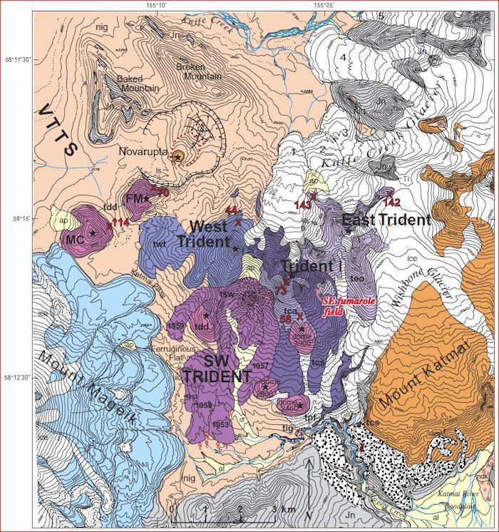
There are at least five and as many as eight dacite lava domes on the lower west and south flanks of the Trident Group. The Novarupta vent also opened in the vicinity of the lower domes, making Trident the closest volcano to the 1912 vent. The two largest domes are Falling Mountain and Mount Cerberus. Their lavas are dacites similar to the smaller and unnamed domes on the flanks. All are glacially scoured. Some are severely eroded. Falling Mountain and Mount Cerberus are not significantly modified by ice, and date 70 ka and 114 ka respectively, and appear to be younger than the other domes on Trident, likely extruded during the growth of Trident I and West Trident. The NE face of Falling Mountain was destroyed during the 1912 eruption, providing some material encased in the pyroclastic deposits. The smaller domes are undated and thought to have been extruded with the growth of Trident I and West Trident.
The domes and thick andesite and dacite lava flows erupted during construction of Trident I and West should have been accompanied by numerous block and ash flows. Glaciers removed most of the older loose material around the base of the Trident Group. The thick pyroclastic deposits cover the entire west apron except along the canyon of Mageik Creek. The creek cut a canyon as deep as 150 m into the basement rocks, exposing remnants of pyroclastic deposits from both Trident and Mount Katmai. These are interbedded with glacial and post glacial deposits. Organic material at the base of an ashfall layer dates around 23 ka, emplaced during glacial retreat at the end of the last ice age.
Southwest Trident
A new fumarole identified in 1951 aerial photos became the vent site for a new andesitic volcanic cone, Southwest Trident, that began erupting in 1953. The new summit cone has a 350 m shallow crater that has hosted small lava plugs. These plugs were destroyed by intermittent explosive activity. Volume of the new cone is around 0.7 km3. The new cone was originally called New Trident. It has been formally named Southwest Trident.
The 1953 – 1974 eruption sequence generated plumes from explosions 6 – 9 km tall, occasionally as high as 12 km. Most of the ashfall and at least half the lava were erupted before June 1953. Significant eruptions were over by 1963. Numerous fumaroles are still active on the upper parts of the cone.
The initial eruption put a 10 km plume above the volcano followed by smaller gas, ash and lava flows. Over the next two decades, sporadic explosive and effusive activity built a 3 km2 cone of block and ash deposits, scoria, and interlayered lava flows above 1,500 m. Four blocky, leveed lava flows erupted from the central vent 1953, 1957, 1958, and the winter of 1959 – 1960. The flows are 30 – 70 m thick and 2.5 – 4.5 km long. They total around 0.35 km3 of eruptive volume.

The Dec 1968 eruption put ash 100 km from the volcano. It destroyed a plug and did not produce a lava flow. The likely date of the eruption was a couple weeks before observation on Dec 9. There were six relatively large earthquakes Nov 1968. These ranged M 3.9 – 5.0. Smaller earthquakes were detected in Oct. Seismic coverage at the time was poor compared with today.
The Southwest Trident cone, its lava flows, multiple destroyed lava plugs, and thin local ash cover are representative of the sorts of eruptions that built most of Trident and the neighboring stratovolcanoes, Katmai, Mageik, Martin and Griggs. There is a striking similarity between the new Southwest Trident cone and the four summits of Mount Mageik; each a discrete eruptive center, source of numerous lava flows; each with a discrete conduit independent of its neighbors; each having a separate period of activity. Had the cone and lavas of the 1953 – 1974 Trident eruption erupted on the other side of Katmai Pass; it would have been called a fifth eruptive center of Mount Mageik. The formation of Southwest Trident can be viewed as an analog to eruptions that built Mageik.

Trident Eruptions
97% of Trident erupted over 140 – 44 ka. Eruption focus moved generally westward over time. East Trident is the oldest at 143 ka. Trident I dates 140 – 100 ka. The flank lava domes including Mount Cerberus and Falling Mountain were built during and after this phase. The oldest lava from West Trident dates 55 ka, about 55 ka after Trident I last erupted. Most eruptions from these edifices have been lava flow and lava dome extrusions. Several have produced small to moderate pyroclastic flows, mostly from dome collapse. One of these near the southern foot of Trident was thick enough to dam local streams, creating a local lake followed by breakout flood and lahar capable of making it all the way to the coast.
Smithsonian GVP lists 15 eruptions from Trident 1913 – 1974. The 1953 – 1974 dome building cycle had 12 eruptions, two thirds of them VEI 3. The rest were VEI 2.
Tectonics
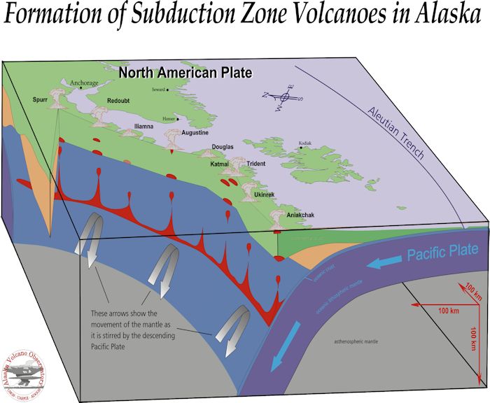
Volcanic activity in the Katmai region like all volcanic activity along the Alaska Peninsula and Aleutians is driven by the subduction of the Pacific Plate beneath North America. This portion of the volcanic arc, the Eastern Aleutians, is segmented into the Cook and Katmai segments. Larger caldera forming volcanoes are located near segment boundaries. Intrasegment volcanoes are smaller stratocones. Ten of the 22 volcanoes along the 540 km long volcanic front have erupted in recorded history. Another six show hydrothermal activity.
The Benioff zone dips at 45° beneath the volcanic arc to a maximum depth of 200 km. The Cook and Katmai segments are not parallel but are misaligned by 35°. This is thought to reflect a change in strike and perhaps a lateral warping of the subducting plate. Cook segment volcanoes to the N of Katmai line up at the 100 km isobath. Katmai segment volcanoes lie on a change in the underlying seismic zone from 75 – 100 km. There is good evidence that crustal tectonics play an important role in localizing volcanism, as narrowly spaced linear groups of volcanoes appear to be positioned on a deep crustal fault underlying the volcanic front. Transverse faults divide the arc into subsegments and localize larger magma reservoirs at shallow depths.
Intrasegment volcanoes tend to erupt andesites with minor dacites. These products are uniform. Segment boundary volcanoes erupt a wider range of magmas including basalts and rhyolites. Greater crust thickness in this region allow magma ponding at shallow levels, which in turn differentiates producing dacites and rhyolites.
Conclusions
Mageik and Trident are recently active Katmai volcanoes with highly active magma-connected hydrothermal systems. The plumbing system of all these volcanoes is complex and interconnected. Trident was the most recently active and is the closest to the 1912 Novarupta vent. The volcanoes at Katmai are dangerous, well monitored, and capable of anything from a periodic cone-building to a cataclysmic eruption. Mageik and neighboring Martin hosts small crater lakes with significant steam and gas emissions.

Additional information
Alaska Volcano Observatory – Mount Mageik description and information
Alaska Volcano Observatory – Trident Volcano description and information
Catalog of Historically Active Volcanoes in Alaska, Miller, et al, USGS Open File Report 98-0582

