

Volcanic ash and clouds are illuminated by lava from the crater of Mount Raung as seen from Songgon, Banyuwangi East Java, Indonesia on July 11, 2015. Reuters/Zabur Karuru/Antara Foto
Whenever you have your automatic text translation switched on while reading up on Gunung Raung you will be informed that the roaring mountain is erupting or a great roar has been heard from Mt. Roar. This is what the Indonesian word raung means in English – roar. Which is probably just appropriate as all eruption reports begin with “distinctive rumblings were heard for weeks before” accelerating to “loud explosion sounds and roaring noises accompany the eruption”. Mt. Raung is a quite large volcano on the borders of the three districts Banyuwangi, Bondowoso, and Jember, in Eastern Java, Indonesia.

Due to its remoteness from densely populated areas the media seldom report on Raung, and PVMBG rarely bother to raise its alert level if it displays only moderate strombolian activity. There are just a few small villages at around 10 km distance, and all minor activity takes place at the bottom of the 500-m-deep caldera, so that it often was not even noticed by residents when the volcano erupted.

Gunung Raung. antaranews.com
It’s different this time. The present eruption which began in mid June is still small in terms of VEI, but has a huge economical impact due to the ash plume going in the “wrong” direction.
THE PRESENT ERUPTION
Video via YT by Aris Yanto, taken during an expedition on July 07, 2015.
In their weekly summaries PVMBG reported that, during infrequent times of clear weather white to grey plumes and occasionally weak incandescence had been observed since December 2014, also rumbling sounds were reported by residents. Seismic tremor sharply increased on 21 June. 28 June was characterized by strombolian activity, roaring, ash plumes that rose 300 m, and a loud thumping sound heard 20 km away in the evening. Incandescence from the crater was clearly visible from the observation post in Banyuwangi.

Incandescence from Raung, 03.07.2015 (Photo via VolcanoAlert/Twitter)
PVMBG raised the Alert Level to 3 (on a scale of 1-4) on 29 June, and a restriction zone was established around the crater within a 3-km radius. During 1 and 3-7 July Darwin VAAC reported ash plumes from Raung to altitudes of 3.7-6.1 km (12,000-20,000 ft) a.s.l. and drifted 25-110 km E, ESE, and SE. On 5 July BNPB reported that roaring sounds were heard from continuous vulcanian explosions and strombolian effusive activity at Gunung Raung.
Volcanologist Burhan Alethea, in the Volcano Observation Post (PPGA) G. Raung in Banyuwangi, said that Mt. Raung currently has two active vents. According to the observation results of NASA satellite Landsat 8, on June 25, 2015 two vents were clearly visible. But when Mt. Raung erupted on October 19, 2012, only one vent was detected in the satellite photos.

by Ara Ramadhanti via Pinsta.me
Around 200,000 people reside in the potentially affected area, 23 villages across six districts could be affected. So far no evacuations were necessary, but shelters are prepared, just in case. The Head of Geological Agency of the Ministry of Energy and Mineral Resources (DEMR) Mr. Surono calls on people who live around the foot of Mount Raung, East Java, not to panic and not to believe that the mountain will have a disastrous eruption in the near future. Surono explained that the eruption of Raung is of Strombolian type. This means that the eruption, spewing incandescent material, will be like sparks of fireworks seen in the night. He thinks that due to the energy emitted by Mt. Raung gradually since 2011 there will not be a large eruption. This would be different if there were an obstruction in the volcanic conduits, making the eruption dangerous when accumulated energy is suddenly released.

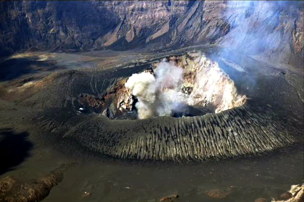
Aerial view of Mt. Raung. Photo: B. Fourie

Flight delays (Photo: Koran Tempo)
Since 9 July five airports in East Java, Bali and Lombok had been closed; four of them reopened at the weekend, but Bali’s Ngurah Rai airport closed again on Saturday (reopened and re-closed on Sunday, as with other airports). Indonesian volcanologist Gede Suantika said that Mount Raung emitted ash up to 1,000 metres into the air on Sunday and the winds had pushed the ash in a south-easterly direction towards Bali again.

This photo has been published on Pinsta.me by the user “_activ_” who was going to Bali for their honeymoon. No wonder there was a lot of hassle involved with the journey, as the “BUGGER” Mt. Raung erupted right into their path of happiness!

On July 11, 2015, the Operational Land Imager (OLI) on Landsat 8 got a closer view (about 25 meters per pixel) of Raung’s summit caldera. It appears to be covered with fresh lava.

On July 12, 2015, the MODIS on NASA’s Aqua satellite captured the plume emanating from Mt. Raung
At this time of year the dry season begins and the meeting of cool damp air masses with dry warm air causes higher wind speeds in the unfavorable SE direction. – Reports on 13 July say that the seismic activity of Mt. Raung has somewhat decreased but nevertheless, ash emission is higher and denser now with black plumes abt. 1000m high.
Asked by the press (probably for the umpteenth time) if the eruption of G. Raung could have an effect on the nearby volcanoes of Ijen Complex, Mr. Surono had one convincing answer – he said: I have told you this before, a volcano doesn’t erupt flu viruses, so can not infect other volcanoes!
THE VOLCANO – GUNUNG RAUNG or Raoeng | Rawon | Roung

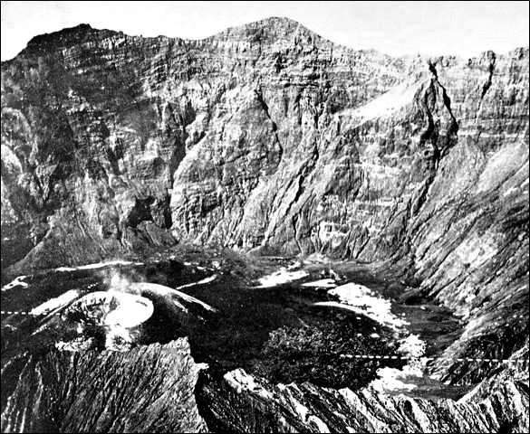
Raung volcano, near the eastern tip of Java, is truncated by a steep-walled, 2-km-wide caldera. One of Java’s most active volcanoes, Raung produces frequent moderate explosive eruptions, like this one in 1988 from a cone within the caldera, that keep the upper flanks of the volcano sparsely vegetated. Raung forms part of a NW-SE-trending chain of volcanoes constructed near the SW rim of the massive Ijen caldera.
Photo by Willem Rohi, 1988 (Volcanological Survey of Indonesia).

Raung rising on the SW rim of the huge Ijen Caldera Complex.
Raung volcano is rising from a ring fracture around the SW part of the rim of Ijen caldera, but is usually considered not to be part of the caldera complex.
Mt. Raung is part of the oceanic island arc in the Java-Sumatra subduction system, where the Australian plate subducts beneath the Eurasian plate. There are a lot of controversial theories published concerning the detailed contemporary processes as well as the geological history of the systems involved (see link to bibliography below). It produces Andesite/Basaltic Andesite lavas and Basalt/Picro-Basalt. Since 1586 Mt. Raung had 69 recorded eruptions, the largest among them were: 1x VEI 5 (1593), 2x VEI 4, 3x VEI 3. Its last eruption took place in 2008.
Cinder cone on the caldera floor that formed in the 1913 eruption. Screenshot from the below video by “HK”.
The pyroclastic cone at the lower left on the floor of Raung’s summit caldera formed during an eruption in 1913. A lava flow erupted from the cone
extends to the right across the caldera floor. This aerial photo, taken sometime before 1926, shows the steep, roughly 500-m-high SW caldera wall in the background. Photo published in Taverne, 1926 “Vulkaanstudien op Java,” (courtesy of Volcanological Survey of Indonesia).
The 3332-m-high summit of Gunung Raung is truncated by a dramatic steep-walled, 2-km-wide caldera that has been the site of frequent historical eruptions. The upper part of the mountain is unvegetated which gives the appearance of a grey collar. Raung contains several eruptive centers constructed along a NE-SW line, with Gunung Suket and Gunung Gadung stratovolcanoes being located to the NE and W, respectively. The formation of Gunung Raung itself is not dated but a pyroclastic flow deposit produced by the Gunung Suket, sampled in the Caldera of Ijen (itself dated to about 50,000 years) gives an age of 37900 +/- 1850 years.

A quarry displays a cross section of a debris-avalanche hummock, showing bedded layers of tephra on the right and a segment of a lava flow on the left. Both the the massive lava and the unconsolidated tephra layers were transported relatively intact for about 30 km within a massive debris avalanche from Raung volcano in eastern Java. The preservation of original stratigraphy from within the volcano is a common feature of debris-avalanche deposits. Photo by Lee Siebert, 1995 (Smithsonian Institution).
Though it is not immediately obvious, Raung is actually a huge volcano on the flanks of another older, bigger volcano named Gunung Gadung. Gadung is the ‘ancestral’ volcano that formed before Raung, but Gadung has since collapsed. The timing of this collapse is unknown (tens of thousands to hundreds of thousands of years), but the numerous hills (debris-avalanche hummocks) scattered along the curving 79 km path between the old mountain and the Indian Ocean indicate that it was one of the largest volcano avalanches in the known geologic record. At some point before, during, or after the collapse of Gadung, magmatic material began to come out of the east flank of Gadung. This eventually built the edifice that is Raung today (Is it possible that the building of Raung on the east flank caused Gadung to collapse towards the west flank?).
![Illustration of the Raung Caldera built on the east flanks of the ancestral Gunung Gadung. Gadung was probably taller than Raung – tall enough that its eastern flanks would be visible on the inside of Raung’s caldera. [Figure Credit: Seibert 2002, Landslides resulting from structural failure of volcanoes, Fig. 25. Comment J. Wellik].](https://volcanohotspot.files.wordpress.com/2015/07/raung08.jpg)
Illustration of the Raung Caldera built on the east flanks of the ancestral Gunung Gadung. Gadung was probably taller than Raung – tall enough that its eastern flanks would be visible on the inside of Raung’s caldera. [Figure Credit: Seibert 2002, Landslides resulting from structural failure of volcanoes, Fig. 25. Comment J. Wellik].

Illustration of prehistoric G. Gadung debris-avalanche (by the author/Google Maps).
Because Gadung has since collapsed, an untrained eye only sees one large volcano: Raung. There are several things you can look for, however, to clearly identify the remaining presence of Gadung. One, there is actually a jagged cirque on the west flank of Raung. This is the cavity left behind from Gadung’s collapse. A small, resurgent cone sticks out of that cirque in the same spot that Gadung used to sit (J. Wellik).

Mt. Raung plume visible from the village Melaten, Bondowoso, on Sunday 12.07.2015. (AFP Photo/Zabur Karuru).
To get an idea of this wonderful mountain I recommend watching this 7min video of climbing Raung, with heart-stopping lofty scenes and a short round view of the crater interior. The description on YT reads: “Oct 18, 2014 “Gunung Raung” One of the extreme mountains in Indonesia, located in East Java Province, Mount Raung is infamous for its difficult terrain and technical climbing requirement to attain the highest peak (Puncak Sejati). Standing 3344m asl, Raung has 9 Checkpoints […] and 4 Peaks; Puncak Bendera, Puncak 17, Puncak Tusuk Gigi, Puncak Sejati. 3 days are required to attain the summit […] Mount Raung offers ultimate breath taking views from Puncak Bendera to Puncak Sejati, where technical climbing skills and extreme caution are a must since failure might lead to death. […] Raung Sejati, Push Your Limit!” By “HK”.
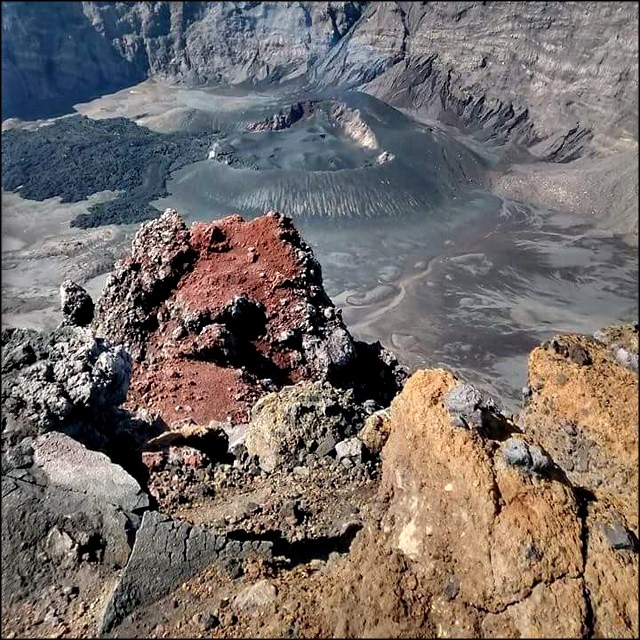
Raung caldera. by okkygunawan via Pinsta.me
Enjoy! – GRANYIA
SOURCES & FURTHER READING
– Detik News
– Encyclopedia of Earthquakes and Volcanoes; A. E. Gates, D. Ritchie
– Ndeso Adventure/Aris Yanto Blog – Mt. Raung
– ACTIV – L’Association … Connaissance … Transmission de l’Information en Volcanologie
– Catastrophic Landslides: Effects, Occurrence, and Mechanisms
– John (Jay) Wellik’s blog
– Structural architecture of oceanic plateau subduction offshore Eastern Java…
– Segmented Volcanic Arc … in Java Island, Indonesia
– NASA Earth Observatory, Raung
– Bibliography of the Geology of Indonesia and surrounding Areas


Thanks a lot! Very interesting read 🙂
LikeLike
Great post, Granyia. Cheers –
LikeLike
Thank you, you two! 🙂
The volcano Mt. Gamalama on the island of Ternate, North Maluku, Indonesia, erupted this morning at 09:58 hrs. local time, sending dark clouds of volcanic ash some 2 700 meters into the sky. The staff at Volcano Observation Post Gamalama in Ternate said, Gamalama began to show increased seismic activity since Wednesday. So far, it is thought to be phreatic explosions and a restriction zone of 1.5 km has been established. Also, for safety reasons, the airport Sultan Babullah in Ternate has been closed until further notice. (Source: various Indonesian newspapers)
LikeLike
Webcam image a few minutes ago:

http://www.vsi.esdm.go.id/cctv/detail_cctv.php?id=13
Question: Who can access the Indonesian cams and who cannot (country)? It seems that most of the world can view them but we in Germany are denied access. 😦
LikeLike
Thanks Granyia, really nice, and I thought the first pic was a painting,
No cam in Texas either
LikeLike
Do you mean the Link beneath the picture?
Camera works for me – Austria
LikeLike
Thanks, hmm…, I use a proxy server now, so that my location is hidden, and that works. Otherwise I get this when I try look at the cams on the Badan Geologi website (http://www.vsi.esdm.go.id/index.php/gunungapi/kamera-gunungapi):
I hope some more people will write me their experience here, then I can contact Badan Geologi about the matter.
GAMALAMA:
The webcam is showing the same heavy ash plume right now as in my screenie yesterday (yes, it is working! 🙂 ) Gamalama is still at alert level 2, the Ternate airport and another small one nearby are still closed, God knows what that volcano is planning.
– I alwayis thought phreatic eruptions consist of separate explosions, not of continuous activity… there must be a stream of water going in? Or, like with Colo – and Ternate being a similar island, seawater is seeping in providing a constant supply. Now, that would be not good, because it is so unpredictable. But I guess if that was the case, scientists would have informed about the danger. Just thinking.
RAUNG
Still very busy too, no change, although it was said in one newspaper that the activity decreased somewhat. But they have said that before.
LikeLike
NO cams in Andorra
Within a few days I will try it in France (i’m sorry, forgot about it yesterday..)
LikeLike
Updates UBINAS and SABANCAYA
Though seismic activity at Ubinas has decreased there are still very ashy explosions/exhalations (what’s the difference?) annoying the residents of the area.
Sabancaya, who had been emitting steam plumes (recently with low ash content) for months, has been declared entering a new magmatic eruptive phase officially. In recent ash samples dominating amounts of juvenile (fresh) magma shards have been found.
On both volcanoes, a specialist of the Geophysical Institute of Mexico UNAM (Universidad Nacional Autonoma de Mexico) and professionals of INGEMMET conducted monitoring of sulfur gases (SO2). These measurements were made on July 8/9 with an ultraviolet camera and DOAS system (Differential Optical Absorption Spectrometer), and gave as results the flow of sulfur dioxide issued in recent weeks. The results show
SO2 values of 500 – 4000 tons/day for Ubinas,
SO2 values of 500 – 2500 tons/day for Sabancaya,
which are classified as moderate to large flows, meaning an atypical activity.
For those interested in tephra composition:
Volcanological Observatory experts from INGEMMET made an observation climb to the top of Sabancaya during 09/10 July. They acknowledged ash emitted by the volcano in recent weeks. This ash is gray and grains are less than 0.5 mm. In crystals of plagioclase, biotite and amphibole (magmatic silicates) are observed. Plagioclase crystals are less than 0.5 mm, some have tabular forms. Biotites are up to 0.2 mm and are slightly altered. Amphiboles are encompassed by the fresh and juvenile lithic. Likewise, glassy matter measuring up to 0.1 mm is observed, this is translucent and amorphous. Lithic fresh or dark gray juvenile, measuring up to 0.3 mm and rusty reddish stone measuring up to 0.2 mm were also sampled in two types of different stone. Importantly, juveniles predominate in the ash fragments suggesting that the Sabancaya entered an eruptive phase of magmatic origin, which may increase in the coming weeks or months.
Sources:
Click to access reporte_ubinas_201530.pdf
http://ovi.ingemmet.gob.pe/?p=1335
http://ovi.ingemmet.gob.pe/?p=1319
LikeLike
What’s the difference between DOAS and COSPEC? Or are they just different names for the same piece of kit?
LikeLike
If I understand correctly, the method of the two is basically the same – measuring the amount of ultraviolet light absorbed by sulfur dioxide molecules within a volcanic plume. While COSPEC has been in use for over 20 years (originally, it was developed for measuring industrial pollution), DOAS is a new (2015) portable instrument that is faster and lighter for more convenient use.
DOAS: http://www.j-sens-sens-syst.net/3/355/2014/jsss-3-355-2014.html
LikeLike
Thanks for that, Granyia; from the link it looks like a good development; lighter, more sensitive, more versatile, and designed for the job, not an adaptation of existing ‘industrial pollution’ equipment
LikeLike
No camera, Gamalama and an empty box, nothing else
LikeLike
are you paying for the proxy server?
LikeLike
No, just google for free proxy, tip-toe your way through the advert traps, and paste your desired URL into the appropriate box. It’s mostly further down, less obvious than the ads.
LikeLike
I was quite shocked earlier today when I saw the webcam images of Mt. Guntur volcano (Indonesia)… there was fire on the slope in several spots! Googling the local newspapers, it turned out that forest fires had emerged in different places, destroying several hundred ha of wood and creeping up the slope. Although there were some fires each year in the dry season, none have been so big. The spokesperson said, it is as yet unknown what exactly sparked the fires. A lot of mountaineers have been called back and all are accounted for. They said on Sunday morning that hopefully all fires are extinguished, but it seems they were wrong about that.
Nothing to see now; I just hope it is not the volcano secretly playing with fire! 😉
LikeLike
Gosh, the Raung hot spots look worse than ever (top right on this page). It’s plume was going more in NW direction today, giving Bali airport a break, but instead Surabaya airport had to close.
Also, Gamalama is still causing trouble. 1500 people had to be evacuated. – As if that were not enough, Sinabung, who’s activity had abated a bit, is producing pyroclastic flows again.
I feel sorry for all those people who have to live with the masks and sometimes hard hats all the time. It must be a horrible feeling if you can’t take a deep breath of clean fresh air for such a long time.
LikeLike
Thank You, I feel horrible for them, hope it doesn’t get any worse.
LikeLike
Cleeveland volcano in the Aleutian Islands (Alaska) has been set on orange alert level today. AVO detected an explosion at Cleveland volcano at 08:17 AKDT (16:17 UTC). Satellite views below about 30,000 feet above sea level have been obscured by clouds. Observers from a boat on the northeast side of the volcano reported seeing a dusting of ash on the snow near the summit of the volcano as well as moderate steaming from the summit area.
This is a composite Landsat 8 image of Cleveland from the afternoon of 14 June 2015 (last month!). The shortwave-IR data in color shows elevated temperatures in the summit. Note the light dusting of ash on the north flank as observed by C. Read on his commercial flight back to Anchorage. Snow-free ground near the summit is also evident, but not necessarily unusual.
And this is what an explosion in Cleveland looks like on the helicorder… who would have thought?!
(from AVO, http://www.avo.alaska.edu/activity/Cleveland.php)
Staying in the northern realms, in the Kuril Islands both volcano Chirinkotan and volcano Snou on the Chirpoi caldera (Brat’ya Islands) have shown hot spots in Satellite images yesterday. Subsequently, Chrinkotan’s alert level has been raised to yellow, while Snou had been yellow before.
LikeLiked by 1 person
Pingback: Lamongan Volcanic Field, East Java, Indonesia |