
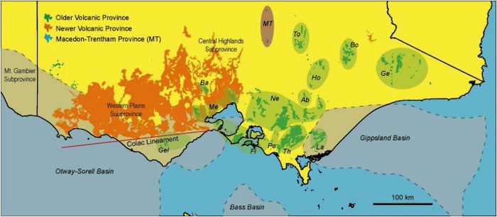
Schematic of volcanic provinces in Victoria. Older volcanics are depicted in green, Newer in orange, and Macedon – Trentham in blue. Image courtesy Meeuws, et al. https://www.sciencedirect.com/science/article/pii/S0264817216300605
This post will cover remaining volcanic activity in southern Australia. The majority of it is in the southeastern state of Victoria. The most recent activity has spilled over the border to the west into South Australia. Finally, we will take a look at volcanic activity in the Bass Strait, the water separating Tasmania from the rest of the continent and a quick look at volcanic activity in Tasmania.

Raised relief map of Victoria showing major cities and roads. Image courtesy Map Centre https://www.mapcentre.com.au/shop/item/victoria-raised-relief-95-x-67
Victoria
Victoria is the second most populous state in Australia with 6.4 million people. It was originally part of New South Wales and was split off in 1851 as a separate colony and became a state when the nation was established in 1901.
The state is the second largest economy in Australia and accounts for a quarter of its gross domestic product. Finance, insurance and health care are the largest employers and revenue producers. Agriculture and ranching are also important. Victoria has a diverse manufacturing and mining sector, thogh mining is a small employer.
Climate varies from semi-arid hot summers in the NW to temperate and cool along the southern coast. The Victorian Alps, part of the Great Dividing Range have the coolest temperatures in the state.

Topographic map of Tasmania showing glacial coverage during last ice age. Image courtesy Erik Wapstra https://www.researchgate.net/figure/Topographic-map-of-Tasmania-indicating-sampling-sites-for-Niveoscincus-ocellatus-filled_fig2_279299480
Tasmania
Tasmania is the smallest and least populated state in Australia. It was populated by aboriginal peoples before British settlement as a penal colony in 1803. Hostilities between the aboriginals and the colonists went on for nearly 30 years before they were stopped.
It is located in the Roaring Forties of the Southern Ocean and was heavily glaciated during the last ice ages. Climate is relatively cool with four distinct seasons. Primary economy has been mining, agriculture, forestry products and tourism.

Newer Volcanic Province. Grey depicts lava and scoria coverage. A number of eruptive centers are also depicted. Image courtesy Kevin’s Walk on the Wild Side blog. https://images.theconversation.com/files/232435/original/file-20180817-165946-12lw87m.jpg?ixlib=rb-1.1.0&q=45&auto=format&w=1000&fit=clip
Victoria Volcanics
There are two main fields in Victoria – the Newer Volcanic Field and the Older Volcanic Field. Interestingly enough, the names properly reflect the actual age of volcanic activity in each field. Both are further subdivided into subgroups.

Schematic of Older Volcanic Province and Newer Volcanic Province. Image courtesy Matchan et al. https://www.sciencedirect.com/science/article/pii/S1871101411000112
Older Volcanic Province
Mainly basaltic volcanic activity took place 95 – 19 Ma. It was sporadic, relatively low volume, and widespread. There are 14 provinces based on age and chemical composition. These are then grouped into larger groups based on age, distribution and composition. Most of these provinces are eroded, weathered lava fields, valley fill lavas and cones. There are some pyroclastic cones identified. While there is some variation between lavas and other erupted products, there is no correlation between basalt types, age or location. There are six fields that became more alkaline / fractionated during their lifespans.

Mount Elephant cinder cone. Image courtesy Explore Australia web site where it is mislabeled. http://www.exploreaustralia.net.au/Victoria/South-West-Coast/Camperdown
Group 1 includes three fields dating 95 – 55 Ma. Activity is mostly limited to two small fields 140 km apart. Lava flows up to 160 m thick have been measured. Lavas appear to have been fed by dikes parallel to the axis of local grabens.
Group 2 includes four fields dating 59 – 38 Ma. It is an E – W trending belt 620 km by 70 km wide. Over 75% of all volcanics are subsurface. The largest field is Flinders at with at least 700 km3. Lava flows and other volcanic products are found along the coast. While most of the erupted materials are lavas, there are massive pyroclastic beds present.
Group 3 includes four fields dating 44 – 31 Ma. These fields are generally younger and less prolific than Group 2. The four separate fields are located on the eastern highlands in a belt measuring 270 km by 115 km wide (N – S). Some remaining lavas measure up to 250 m thick. The majority of material erupted are various basalts.
Group 4 includes five fields dating 29 – 19 Ma. Erupted materials are generally various basalts filling valleys. The youngest basalts transition to alkali basalts.

Schematic of location of Macedon Trentham Volcanic Province. Image courtesy Reynolds, et al. https://pubs.geoscienceworld.org/jgs/article-abstract/175/4/694/529588/the-importance-of-subsurface-lithology-in?redirectedFrom=fulltext
Macedon – Trentham Volcanic Province
This is mainly trachyte lava flows, domes and plugs. Their coverage is limited. The province was active 7.0 – 4.6 Ma. This activity is closely associated with the Newer Central Highlands sub-province. Most of the volcanic hills are small, single rock type, and were formed during relatively short-lived volcanic events.

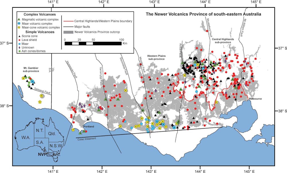
More detailed schematic of Newer Volcanic Province showing location of sub-provinces, volcanic features, and proximity of activity to the ocean. Note that most of the lava activity is in the Central Highlands while most of the maars are in the Western Plains. Finally, note the activity reaches into the Southern Ocean near Portland and Warmambool Image courtesy Jozua van Otterloo, Australian Geographic. https://www.australiangeographic.com.au/topics/science-environment/2016/05/australias-volcanic-history-is-a-lot-more-recent-than-you-think/
Newer Volcanic Province
The Never Volcanic Province has been active from 4.6 Ma to recent times, with the most recent eruption 4,500 years ago. It is well preserved based on age and includes lava plains, lava shields, scoria / cinder cones and maars. Volcanics are typically alkaline basalts.
The most prominent Newer features are scoria cones, maars, tuff rings and major valley lava flows. The oldest activity was the lava flows. Eruptions are generally low volume. Overall volume of pyroclastic materials in the province is estimated around 1 %.
This scoria cone and shield volcano field last erupted some 5,000 years ago. The two newest eruptive centers are Mounts Gambier and Schank. Both of these produced a complex eruptive sequence including scoria cone, lava flows and maar formation toward the end of the eruptive cycle. There is some confusion in the literature over which eruptive center was last active, though it looks like both could have been active simultaneously.

Mount Schank from the air. Photo courtesy Pinterest uploaded by Packed Nomads. https://www.pinterest.co.uk/pin/667588344735724550/
There are no fumaroles, hot springs or anomalous temperature gradients indicating current or future activity.
The field has small volume, short-lived, monogenetic eruptions caused by basaltic, intraplate volcanism. The field covers 15,000 km2. While eruptions started as far back as 7 – 6 Ma, the majority of activity took place 4.6 Ma – recent. The field has 683 eruption vents including 400 cinder cones, 40 maars, tuff cones and tuff rings, 200 small shield volcanoes and valley filling lava flows. New eruptive centers are still being discovered. The highest volcano is Mt. Elephant, 240 m. Total erupted products are 1,300 km3.
There is no substantial differentiation of magma before it reaches the surface. Supply does not demonstrate conduit interconnectivity or formation of magma chambers. Tectonic stress reactivating weakness allowed small quantities of magma to reach the surface. Volcanic eruptions in the field range from VEI 2 – 4, with the most recent eruption at Mount Gambier being a VEI 4.

Byaduk Caves. These are lava tubes, sinkholes, domes and chambers connected to eruptions from Mount Napier. Image courtesy Red Nomad OZ blog. https://www.redzaustralia.com/2014/01/8-random-adventures-on-the-kanawinka-geotrail/
The field includes three sub-provinces. The Central Highlands contains 54% of all known eruptive centers. It is located NW of Melbourne. The Western Plains sub-province extends 320 km from Melbourne to Portland and contains 42% of the volcanic centers. Finally, the Mt. Gambier sub-province is 60 km to the west and contains only 4% of the eruptive centers. Gambier is 50 km west of closest neighboring volcanoes. Phreatomagmatic eruptions are located almost exclusively in Western Plains and Mt Gambier sub-provinces due to presence of ground water.
There are two types of volcanoes in the field: simple and complex. While all eruptions are monogenetic, the complex volcanic centers include some combination of lava shields, scoria cones, spatter cones, maar volcanic complexes, and maar-cone volcanic complexes.
Maar complexes combine maars, scoria craters, and lava flows. Eruptive vents are strongly aligned with and controlled by fracture zones, NW – SE extensional structures.

Wannon Falls near Hamilton, Victoria. Note the water flowing over multiple layered lava flows and other volcanic debris. Image courtesy Weekend Notes.com blog. https://www.weekendnotes.com/hamilton-southern-grampians/
Newer Volcanic Province does not have many earthquakes, indicating overall lack of underlying activity. Estimated eruption recurrence estimated on the order of 10,000 years. This field is thought to be dying as the plate continues to travel north of the underlying low velocity zone underneath it.
New members of this field are still being discovered. Many of the known ones are on private land. Mining the privately held scoria cones is not uncommon. There is local interest in public ownership and preservation of the older volcanoes. One such example is the Volcano Discovery Trail near Penshurst. The Kanawinka Geopark is located on the southern coast, on the southern edge of the Newer Volcanic Province. It has multiple lava flows, eruptive centers, scoria quarries and maars.
The larger NVP is considered to be a continental volcanic province, but there has been activity off the coast to the south, with shallow marine eruptions within 10 km of the shoreline. Lady Julia Percy Island has bedded pillow lavas, hyaloclastite, and the remains of a tuff cone capped by lavas. Small islands offshore from Portland look like tuff cone forming eruptions took place in the water.

Mount Napier volcano. Image courtesy Don Fuchs Australian Geographic. https://www.australiangeographic.com.au/topics/science-environment/2017/05/volcanic-victoria/
Central Highlands Sub-Province
The Central Highlands are distinct due to a high proportion of lava flows and the scarcity of phreatomagmatic eruptive products. There are extensive valley lava flows and small lava plains. Most of the activity took place 4.5 – 2.0 Ma. There are about 250 volcanoes present, only 6 of which are maars and tuff rings.
Lava shields and cones are common in the Central Highlands. They are typically small, 4 – 5 km in diameter and 100 – 200 m above the surrounding plains. Some have multiple craters. Some evolved from shields to scoria / cinder cones. The only ones sufficiently eroded to expose internal strata are on the coast.
Lava flows associated with the shield volcanoes are generally short. There are some long lava flows known. The Harman Valley lava flow from Mt. Napier is 25 km long. The Tyrendarra lava flow from Mt Eccles flowed 50 km south, perhaps entering the sea.

Cross section of cinder cone of Mount Eccles. Note the bedded layers. Image courtesy Stephanie Sykora Exploring the Earth blog, 2015. http://exploringtheearth.com/2015/01/06/volcanovictoria/
Melbourne – Kilmore area includes Mount Frasier, a complex scoria cone, with 4 – 6 cones surrounding a large depression. Yarrra Valley lava flows in the Melbourne area date to 800,000 years.
Sunbury – Macedon – Malmsbury area is NW Melbourne and includes valley lava flows. Spring Hill, Mount Bullengarook lava flows date 3.6 – 3.3 Ma. Most extensive lava flows are in the Sunbury – Lancefield area. Associated lava or scoria cones are rare and small, Mounts Aitken, Holden and Sunbury Hill.

Scoria layer overlying phreatomagmatic as layers at Mount Noorat. Larger volcanic bombs present in the scoria layer. Image courtesy Stephanie Sykora Exploring the Earth blog, 2015. http://exploringtheearth.com/2015/01/06/volcanovictoria/
Daylesford – Ballarat – Maryborough area contains the majority of Central Highlands volcanoes. Most of the eruption points in Daylesford – Creswick are mostly small, craterless scoria cones, domes or mounds rising 60 – 150 m above the surrounding plains (Bullarook Hill and Mount Moorookyle). The Ballarat area has lava fields measuring tens of kilometers in diameter. Younger volcanoes are generally cinder cones (Mounts Muninyong, Mercer and Warrenheip). There are also large lava cones / domes (Mounts Blowhard, Hollowback and Pigsah). Probable maars and tuff rings are located at Callendar Bay, Stockyard Hill, Lake Learmonth and Hardie Hill. The best preserved of these date 100,000 years ago.

Lake Purrumbete, the largest Newer province maar. Mount Porndon complex is in the background. Lake is stocked with two species of trout, two species of salmon and redfin. Image courtesy I Am 12 Apostles.com. https://visit12apostles.com.au/attractions/lake-purrumbete/#moreinfo
Western Plains Sub-Province
This is the main part of the NVP. It is dominated by extensive plains forming lava fields with central vent eruptions centers. Most of these centers are aligned with suspected basement fault lines. Scoria cones, maars, lava shields and complex eruptive centers are dispersed throughout the province. Lakes are common in this portion of the field. Some of these are maar crater lakes up to 3 km in diameter. Some are simply ponded water in low portions of the plains. Lavas have been in many cases disrupted and modified existing drainage systems. Older lavas are sub-alkaline. More recent ones are alkaline.
It extends more than 300 km near Melbourne to a group of 3 – 2 Ma volcanoes west of Heywood (Mounts Vandyke, Deception and Red Hill). It includes the best examples of large scoria cones, maars, tuff rings, and an extensive lava field with most of the lava volcanoes in the province (Geelong, Bacchus, Marsh and Melbourne). The western part contains both the oldest and youngest and youngest complexes in the province.

The Anakies. A complex of three scoria cones and a possible maar. Image courtesy Victorian volcanoes.com. http://www.victorianvolcanoes.com/volcano/anakies
Lava plains in the Geelong area were erupted from Mounts Duneed, Moriac, Pollock and Green Hills and Anakies to the north. Only Duneed and Anakies have a major scoria cone component, those these are not large. Werribe Plains between Melbourne and Geelong cover 2,000 km2 and are up to 80 m thick. Other volcanoes in the lava plains include Green Hill, Bullengarook, Darriwil, Gorong and Wallace.
The Warrnambool – Derrinallum – Colac region has 15 of the largest scoria volcanoes in the entire province. These include Elephant, Leura, Noorat, Porndon and Shadwell. This area also has many of the best examples of tuff rings and maars. The largest maar of Newer is Lake Purrumbete, 3 km in diameter with a 45 m deep lake in it. It was formed by coalescence of at least three shallow craters.

Mount Lerua and Camperdown. Note complex multiple eruptive centers. Image courtesy Don Fuchs Australian Geographic. https://www.australiangeographic.com.au/topics/science-environment/2017/05/volcanic-victoria/
There are several other maars nearby including Lakes Bullenmerri, Gnotuk, and Keilambete. These date 11,500 – 9,500 years old. Many of the volcanoes in this region are complex with multiple eruption points and products. The extreme example is Red Rock with up to 14 maar forming eruption points and 28 total eruption points in its scoria complex. Other complex sites combining maars, spatter and cinder cones include Keayang Swamp, Mount Cunnies Hill, Lake Mumblin, Mount Leura and Mount Porndon, which has lava flows covering 200 km2. Porndon is thought to date 20,000 years old. Mount Leaura is thought to be 22,000 years old. And Red Rock may be as young as 7,800 years.

Red Rocks volcanic complex from the air. Four remaining maars are shown. String of scoria vents is to the top and right of the maars. Image courtesy Don Fuchs Australian Geographic. https://www.australiangeographic.com.au/topics/science-environment/2017/05/volcanic-victoria/
Red Rock volcanic complex appears to have phreatomagmatic maar-forming eruptions first followed by cone-forming eruptions. The maar fall / surge deposits are also layered with scoria fall deposits. This means that either some scoria cones were active at the same time as the maar-forming eruptions or the maars themselves regularly changed eruption style from phreatomagmatic to scoria cone. The complex dates around 7,810 years ago. Red Rock was not the first volcanic activity in this area, as it followed Newer lavas which dammed regional drainages forming lakes. These were followed by nearby basalt lavas eruptions, scoria eruptions from nearby Mt. Warrion, tuff ring / maar eruptons from nearby Mt. Alvie followed by scoria cones. Final activity at this site was Red Rock maars and creation of the Red Rock scoria cone complex.

Maar rim volcanic deposits at Tower Hill. Image courtesy Stephanie Sykora Exploring the Earth blog, 2015. http://exploringtheearth.com/2015/01/06/volcanovictoria/
Mounts Napier, Eccles and Rouse in the Portland – Hamilton – Warrambool area produced major lava flows followed by scoria cones. The flows are up to 60 km long. The oldest of the lava flows date 1.8 Ma. The Herman Valley lava flow from Napier dates 7,200 years ago. One Mount Eccles lava flow was erupted at a time of low sea levels and dates 29,000 – 6,200 years. Tower Hill has a 2.4 – 3.2 km diameter maar complex that dates 33,000 years old. Sediment dating of buried plant material 8,700 – 6,500 years ago. Scoria cone ash dates 11,400 – 9,980 years old. No explanation of the discrepancy is given. The region also has a number of old small shield volcanoes up to 2 km in diameter and 200 m high. Coastal volcanic complex Cape Bridgewater is a multi-vent complex on a thick lava flow. It also has surge and air-fall tuffs, breccias of phreatomagmatic eruptions. Cape Grant, also on the coast has a sill and a small spatter cone. Cape Nelson has bedded tuffs, breccias, thin lava flows and associated sills. Cape Duquesne is a fourth coastal complex. Additional inland volcanic complexes include Mounts Clay, Deception, Eckersley, Kincaid and Vandyke.

Schematic of eruption sequence at Mount Gambier. Image courtesy Jozua van Otterloo and Cas, RAF in the Journal of the Geological Society, Australian Geographic https://www.australiangeographic.com.au/topics/science-environment/2016/05/australias-volcanic-history-is-a-lot-more-recent-than-you-think/
Mount Gambier Sub-Province
This sub-province is 60 – 80 km west from the rest of the field. It has two distinct groups of volcanoes, one older than 2 Ma and the other active within the last 10,000 years. This province includes clusters of central scoria cones and associated maars, tuff rings, phreatomagmatic base surges, and air fall deposits with minor lava flows.
15 older eruptive centers are called the Mt. Burr group. They are aligned along basement fractures and fault lines. The group dates 2 Ma – 20,000 years old. Total pyroclastic coverage in this group is 100 km2. Other volcanoes in the group include The Bluff, Mounts McIntyre and Watch.

Blue Lake maar, Mount Gambier. Image courtesy Red Nomad OZ blog. https://www.redzaustralia.com/2014/01/8-random-adventures-on-the-kanawinka-geotrail/
Mounts Gambier and Schank are the youngest active complexes in the field. They are in the SE portion of the complex. Phreatomagmatic activity at Gambier produced overlapping maars with bedded surge deposits. Blue Lake crater is the largest. Minor magmatic activity produced minor lava flows, scoria cones. Most recent volcanic activity here dates 4,600 – 4,300 years old.
Activity at Gambier took place in two periods. The first produced small tuff rings and maars. These covered the surrounding area with lapilli and ash. Lava flowed from two sites, a fissure and a scoria cone. This lava reached 20 m thick. The second active period was much larger mostly due to the interaction of abundant aquifer water with magmas. This created a linear group of nested maars and associated base surges. The final activity included steam emissions and the non-explosive intrusion of dikes.

Two maars at Mount Gambier, Green Lake on the left and Blue Lake on the right. The surrounding town is called Mount Gambier. Image courtesy https://www.news.com.au/national/modelling-shows-what-could-happen-if-mount-gambier-volcanic-chain-erupts/news-story/a167eb616992391fd9356c0e421b9228
The Mount Schank complex has a large scoria cone with two craters. There are bedded ash and phreatomagmatic deposits. Dating here varies wildly, either older than 7,000 years or 5,000 – 1,000 years. Charcoal beneath the deposits dates 18,100 years. Most recent dating arrived at a number of 4,900 +/- 540 years, opening the possibility that Gambier and Schank were active at the same time. Activity at Schank proceeded in a similar to that at Gambier.
Mt Gambier and Mt Schank produced micro-Plinian eruptions, explosive columns estimated up to 10 km high. Both complexes also have maar craters. Gambier, the most recent at around 5,000 years has at least 14 eruption vents. Gambier’s eruption started with an effusive basalt / scoria cone eruption. The associated maars formed later in the eruptive cycle, breaking through recently emplaced basalt lava flow with a vulcanian eruption and pyroclastic flows. They are the youngest volcanoes on the Australian mainland.

Simplified geologic map of Tasmania showing location of dolerite coverage. More recent basalt coverage is also depicted. Known basalts in the Bass Basin are partially depicted. Image courtesy Mccue, et al.
Tasmania
Most of the volcanic activity in Tasmania is quite ancient. It had a massive intrusion of dolerite 183 Ma that covered a third of the island with 15,000 km3 of magma, mostly in the form of sills. It is the largest exposure of dolerite in the world (30,000 km2). The intrusion was part of the Karoo – Ferrar LIP, which also covered substantial portions of Antarctica, Argentina, and South Africa. Karoo erupted 3 – 4 million km3 of magmas.
Tasmania has around 400 km3 of more recent basalts in lava fields, valley filling lava flows, and other scattered eroded remnants.

Columnar dolerite jointing at Cape Raoul. Image courtesy Stephanie Sykora, 2015, Tasmanian Geographic. https://tasmaniangeographic.com/the-pillars-at-the-bottom-of-the-world/#!gallery[2]/ML/9175
Sutherland and Wellman in a 1986 paper entitles Potassium – Argon Ages of Tertiary Volcanic Rocks, Tasmania described ages of various basalts found in Tasmania. The following section summarizes their findings.
Northeastern Tasmania has basalts that cap hills and fill valleys. These date 47 – 46 Ma. They are the oldest of the more recent basalts identified in Tasmania. Newer basalts date 16 Ma. One of these flows extends 40 km along a river valley.
Northern Tasmania mainly has basalts in river valleys draining northward into the Bass Strait. These date around 31 Ma. One flow extends 20 km. Many of the valleys draining into the Strait were filled with lavas. Basalts in the western part of the area date 38 Ma.

Dip Falls basalt columns, Tasmania. Image courtesy Grant Dixon Photography.com. http://www.grantdixonphotography.com.au/galleries/image.php?id=1585
The largest volume of lavas in Northwestern Tasmania filled up the river valleys to the extent they formed lava plains in places. These have been dated at 26 Ma and 13 Ma and are up to 750 m thick.
Central Tasmania has lavas that were erupted onto the central plateau of the island. Flows extend in places over 80 km and create lava-dammed rivers. They are over 400 m thick in places. Lavas date 24 – 22 Ma. The plugs date in the 35 – 30 Ma range.
Western Midlands basalts also fill valleys and cap hills near the valleys. They date 36 – 24 Ma. The youngest date is thought to be a minimum, with lavas considerably older than originally dated.
Eastern Tasmania once has valley filling lavas. These date around 26 Ma.
Southeastern Tasmania has some lavas that appear to have erupted into water. These date 30 – 23 Ma.

Schematic of microcontinent creation as Australia separated from Antarctica. Screen Capture from Microcontinent formation around Australia, Gaina, et al.
Bass Basin
The Bass Basin is the Bass Strait separating Tasmania from the rest of the continent. It is thought to have a volume of basalts in it equivalent to those occurring on the island itself. The basalts are layered with sediments and so far drilling has not progressed to the point where all basalts have been identified. Only 4.5 km of the suspected 14 km thick sediments in the basin have been drilled. The minimum date of these basalts is 22 Ma. Activity in this basin may include basalts onshore in Victoria at 17 Ma.

Tectonic setting of Newer Volcanic Province. Screen capture from Volcano tectonic setting of the intraplate, Pilocene – Holocene Newer Volcanic Province (southeast Australia: Role of crustal fracture zones, 2008, Lesti, et al.
Tectonics
Tasmania is thought to be a microcontinent that separated from greater Gondwana when the supercontinent broke up 160 Ma. Further separation from Australia took place 45 Ma when Australia separated from Antarctica. While in close proximity to the rest of the continent, there is geologic evidence that suggests it was never an actual part of greater Australia.
A 2007 paper by Lesti et al suggests that magma reservoirs in the Newer Volcanic Province are located below 32 km, below the crust. Eruptions are strongly controlled and aligned by local fracture zones, mainly related to NW – SE extensional structures created during the rifting from Gondwana. The province location is related to the major Tasman Fracture Zone in the Southern Ocean.
The Bass Strait is sufficiently shallow that aboriginal peoples were able to cross the strait on foot and settle Tasmania during the height of the ice ages when it was dry 14,000 years ago. This is similar to multiple crossings of the Bering Strait land bridge during the height of ice ages over the last 50,000 years.

Interbedded lapilli / tuff layers (beige and tan) with an enclosed a’a’ layer (4 m dark blocky on the right edge). Image courtesy Stephanie Sykora Exploring the Earth blog, 2015. http://exploringtheearth.com/2015/01/06/volcanovictoria/
Conclusions
Volcanic activity in Victoria and a sliver of South Australia is much more recent than that of New South Wales. While there is older activity, that activity appears to be almost exclusively lava fields in nature. Recent activity is monogenetic for the most part, with basalts interacting with the resident water table to construct complex eruptive structures. There is no reason to believe activity in the Newer Volcanic Field is done.

Dolerite rock columns at Ben Lomond, Tasmania. Image courtesy RetiredAussies.com. http://www.retiredaussies.com/ColinsHome%20Page/GreatWalks/Tas/BenLomond/Benlomondlookout.htm
Additional Information
http://volcano.oregonstate.edu/vwdocs/volc_images/australia/schank/schank.html
https://www.volcanocafe.org/australian-volcanoes/
https://www.wired.com/2009/09/is-australia-overdue-for-a-volcanic-eruption/
https://en.wikipedia.org/wiki/List_of_volcanoes_in_Australia
http://austhrutime.com/australian_volcanoes.htm
https://www.aees.org.au/wp-content/uploads/2015/06/48-Mote.pdf
https://agupubs.onlinelibrary.wiley.com/doi/pdf/10.1029/2007JB005110
http://www.australiangeographic.com.au/topics/science-environment/2017/05/volcanic-victoria
https://www.livescience.com/52165-earths-largest-continental-volcanic-ring-discovered.html
https://eprints.utas.edu.au/13905/1/1986-sutherland-potassium-argon.pdf
https://www.sciencedirect.com/science/article/pii/S0301926815003332
https://d28rz98at9flks.cloudfront.net/14660/Rec1993_064.pdf
https://www.amazon.com/Intraplate-Volcanism-Eastern-Australia-Zealand/dp/0521123224
https://academic.oup.com/gji/article/149/2/249/725934
https://academic.oup.com/petrology/article/41/7/905/1457539
http://exploringtheearth.com/2015/01/06/volcanovictoria/
http://www.victorianvolcanoes.com/


Looks like the earthquake swarm off Mayotte last year built a new volcano on the sea floor. And it appears to still be going. h/t WUWT. Note that Granyia did a Mayotte post here on VH last here also. Links to both follow. Cheers –
LikeLike