

Update, Aug. 2019:
In the five years since this was first posted, science continues to grind away, answering a few questions which in turn create a bunch more questions. The Baillie tree ring / ice core team is increasingly of the opinion that the 535 – 540 AD global cooldown was caused by huge volcanic eruptions, at least two of them bracketing the period. A team including Robert A Dull published a paper August 16 entitled “Radiocarbon and geologic evidence reveal ilopango volcano as the source of the colossal ‘mystery’ eruption of 539/40 CE” that appears to nicely define the most recent end of that bracket.
The paper uses 100 new radiocarbon measurements to further tie down the date of the eruption that produced the Tierra Blanca Joven (TBJ) pyroclastic and tephra deposit. The new constraints on age, eruption size (43.6 km3 Dense Rock Equivalent) and sulphur yield tie the major climate forcing eruption. Impact on the Maya was severe with an estimated 100,000 fatalities due to the eruption.
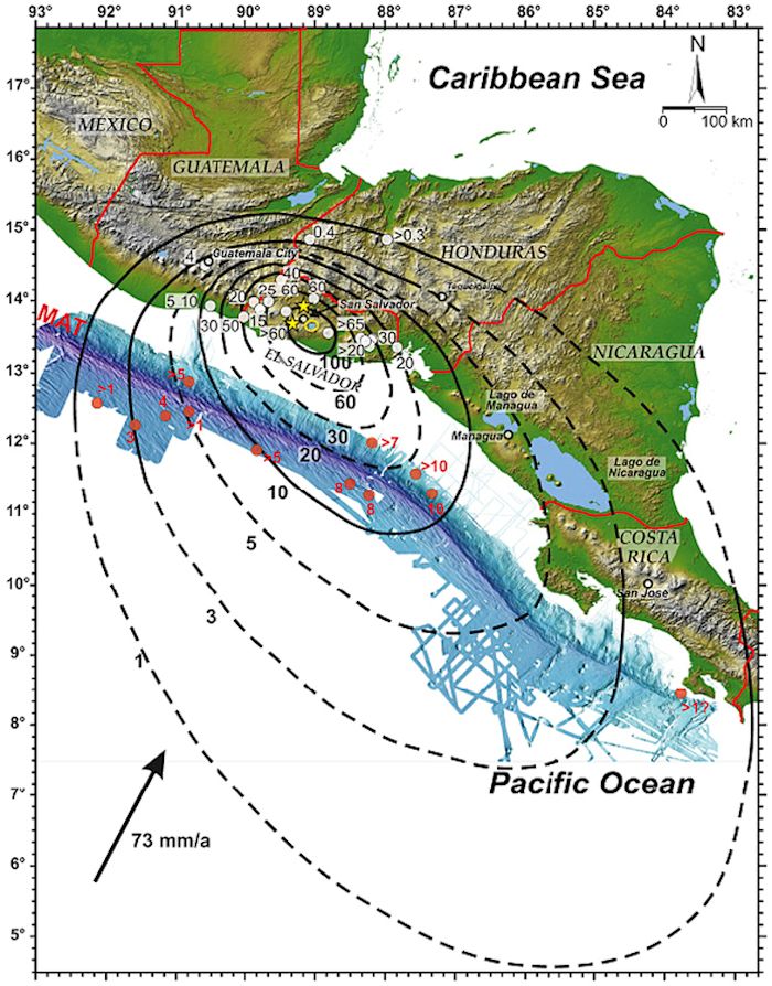
Updated isopatch map of 539 / 540 AD Ilopango eruption from Dull, et al, August 2019.
So if Ilopango was the most recent end of the bracket, where was the older eruption?
End of update
=====================================================================
Original Post
One of the things that tend to grab my interest is large natural catastrophic events, insults to the earth that cause large geologic and population changes over a wide area. Volcanoes fit that bill via massive eruptions and even more massive Large Igneous Provinces. These have been linked to global extinction events and abrupt shifts in climate. The Deccan Traps or the Siberian Traps would be examples of the long-lived events. A single eruption of Yellowstone, Tambora, Baitoushan, Katmai – Novarupta, would be examples of short term large scale events.
Another way to change the geology, climate and distribution of living things is via large impact event, and it doesn’t matter if it is comet or asteroid in nature, just as long as it is big enough. If a sufficiently large impact were to coincide with a large volcanic event, man, many species will at best be at risk. At worst, extinct. One example of this is the Chicxulub impact and the Deccan Traps of India which both date in the 65 million year ago range.

One much more recent event took place around 535 AD, at or perhaps triggering the fall of the Roman Empire and the start of the Dark Ages. Researchers have for years been trying to figure out what happened and in turn what caused the climate disruption.
Whatever happened in 535 AD made the climate in the settled parts of the world, particularly Europe, China and Japan noticeably nastier, colder, and contributed to crop failures which ended up taking down governments. There were a lot of reasons the Barbarians came south for the winter. One reason was that their crops had failed. Similar crop failures hit India, China and Japan. There were reports that the sun did not shine as brightly nor was nearly as capable of warming the ground during these few years. And it got a lot colder with a series of late springs and early frosts.

Data supporting this change in global climate come primarily from two sources. The first is an analysis of ice cores taken from glaciers, primarily in Greenland where we know the ice field has been relatively stable for at least a couple millennia. Antarctica also has significant and stable ice sheets. The researchers look for layering in the ice and attempt to analyze what is causing the layers. An injection of volcanic ash into the upper stratosphere from a particularly large volcanic eruption shows up as a layer in the ice. The ice is analyzed for ash composition, chemical makeup, thickness, persistence (how many years has it fallen?) among other things.
More recent volcanic eruptions like Pinatubo, Katmai-Novarupta (1912), Krakatau (1883) and Tambora (1815) have all left significant layers of ash in glacial ice. Researchers then look for similar layers to analyze earlier (and sometimes later) eruptions then go looking for sources of the ash worldwide.

The other technique is based on a scientific discipline called dendrochronology. This compares tree ring distributions. Using primarily oak trees from Germany, England and Ireland, these people have what they believe to be an accurate chronology back 9,000 years. Oaks end up at the bottom of cold bogs where they do not deteriorate. Sections are overlapped and the chronologies are built backwards over the years.
The nicer the weather, good temperatures, lots of moisture, generally the wider the rings are. Cold, inclement weather, dry weather, early falls or late springs show up as areas of narrower than normal rings.
The climate change of 535 AD shows up in both the ice cores and the tree ring chronologies. And the question becomes what caused it?

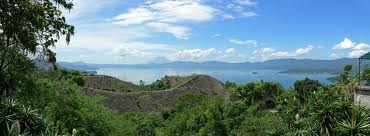
Lake Ilopango looking west toward San Salvador volcanic complex
One known eruption near this time was thought to Krakatau around 416 AD, which is about a century too early. As I have said elsewhere, volcanic eruptions producing significant tephra and pyroclastic flows are difficult to date, as the dating relies on plants that were buried and incinerated during the eruption. In tropical areas, erosion quickly removes significant amounts of this soft material. It does not appear that Krakatau’s ash is all that similar chemically with what is found in the ice cores. Note that there are other ash layers that have yet to be matched to any known eruption.
Researchers took a close look at possible impact events around that time and made no small amount of progress in their attempt to tie this to impact events. The problem is that they never found an impact site. Worse, ice cores from Greenland and elsewhere did not show the expected markers of nanodiamonds or carbon spherules which would have been injected into the atmosphere as dust following a large impact.

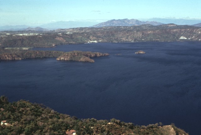
Lake Ilopango and San Salvador Volcanic complex
Why Ilopango?
In 2010, researchers decided that Ilopango was the source of what they call Terra Blanca Joven – essentially Young White Earth, which is found throughout the region. There are a lot of these deposits around, with early estimates of some 25 km3. In some more recent estimates which include offshore, submerged deposits, that total sits at some 85 km3, or 85% that of Tambora’s eruption in 1813. At the upper end of estimates, this eruption grades out at a VEI 6.9.
Lake Ilopango. Photo courtesy Flickr
The oddity of this eruption is the variation in the dating of the Terra Blanca Joven at 260 AD, nearly 300 years earlier than the 535 AD event. Over the years, dating has improved to the point where the eruption and emplacement was moved to the 406 – 536 AD range. A paper presented in 2010 by Dull, Southron, et all dated it at 535 AD. Y
The ash from this eruption is unique, having a relatively high silica content, at around 69% does match nicely with ash found in the ice cores, leading to its adoption as one of (or the only) cause for this climate downturn.
With this in mind, let’s take a look at the geology of El Salvador.
Geology of El Salvador

Central American volcanism is driven by the collision of the Cocos and Caribbean plates. Cocos is moving generally NNE while the Caribbean is moving roughly NW. The collision is a subduction zone generally south of Central America in the Pacific Ocean, complete with trench and a line of typical back-arc, subduction volcanoes onshore in the Central American nations. Eruptions are typically violent, grey, with significant pyroclastic flows and caldera creation. There are at least eight known calderas in Central America.
The body of the Cocos Plate also contains the East Pacific Rise, with active black smoker vents on the ocean bottom.


For its part, El Salvador packs at least 22 volcanoes in a line some 300 km. Most of them have been active during the Holocene. Its capital city of San Salvador sits a few kilometers away from Lake Ilopango which fills the caldera of Ilopango.
Ilopango Caldera and Lake
Ilopango itself is a caldera measuring some 8 x 11 km in diameter. It sits some 450 m above sea level and the lake filling it is some 230 m deep. It sits some 15 km from the capital of El Salvador, San Salvador, a city of some 570,000.
Eruptions
There have been four major dacitic – rhyolitic eruptions known from Ilopango during the last 20,000 years or so. The most recent major one produced the previously mentioned 85 km3 of pyroclastic flows and ash.

The most recent eruption lasted some three months from the end of 1879 through March 1880, ending with the production of a lava dome and a new island in the lake. That eruption was a VEI 3. The island has mostly subsided back below the surface of the lake.

Lake Ilopango and Ilopango caldera from space, LANDSAT
The 1880 eruption produced a dacitic lava dome. Basaltic andesite represents a few percent of the dome. This lava had the same high silica composition as the most recent large eruption. Researchers believe that an injection of mafic magma into the base of a crystal mush triggered this eruption and may also have been the trigger for the earlier one.
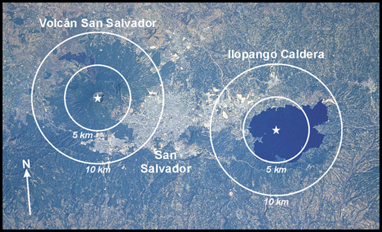
Ilopango, San Salvador and San Salvador Volcano from Space
The thing that the 535 AD eruption is thought to have done was chase a thriving Mayan agricultural civilization out of the Salvador highlands east to the lowlands of present-day Mexico, Guatemala, Belize and Honduras. Remains of several substantial communities, agricultural fields and other man-made locales have been discovered under tens of meters of tephra from the eruption. The natives at the time appear to have decided that living among the volcanoes was simply too dangerous and those not buried in multiple eruptions moved north an east to the lowlands.

Much of the information on volcanic impact on the Maya in Central America came from anthropologists looking at the impact of vigorous eruptions on ancient agrarian societies. One researcher named Payson Sheets researched Ilopango extensively and described the 535 AD eruption as one that proceeded in three phases. The first was a plinian or super plinian plume that put a relatively coarse tephra to a 30 km radius from the vent. It was followed by a pair of pyroclastic flows, one to the north and the other to the west. In one location, this ash is over a half meter thick some 77 km from the vent. One of the flows is measured some 45 km from the volcano. In all, there were over 10,000 km2 covered with ash to a depth deeper than 50 cm.
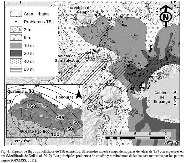
Ilopango Pyroclastic Flow Coverage
Later researchers determined that the winds during the eruption moved the majority of airborne ash south and SE of the volcano where it had a significant impact on local farming, leading to abandonment of the Pacific coast of San Salvador by the Maya.

Dr. Sheets estimates that some 320,000 Maya would have been killed or displaced by this single eruption. The estimate is based on a 40 / km2 population density in San Salvador at the time of the eruption. Note also that the eruption put some 10 m of tephra and pyroclastic flows over the area now occupied by the capital city El Salvador.
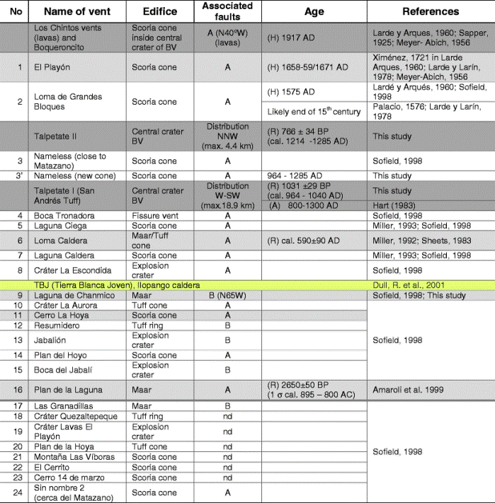
Sequence of eruptive events at San Salvador volcanic complex for the last 3,000 years. Tierra Blanca Joven (Ilopango 535 AD) highlighted in yellow
Central El Salvador was hit with at least three more recent massive eruptions since then, one fairly close to Ilopango which buried the village of Ceren under 5 meters of volcanic debris. This village did not get touched by the Ilopango pyroclastic flows due to its proximity to the San Salvador volcano.

Excavation of Mayan settlement of Ceren. Dr. Sheets pictured. Note layered ash, pumice and pyroclastic flows in the background
Unfortunately, another nearby volcano called the Loma Caldera cooked off some 40 years after Ilopango, burying Ceren under some 5 m of volcanic stuff comprised of 14 layers of wet ash, mud, and pyroclastic flows from lateral blasts. It took a while to determine which of these two eruption finally buried Ceren. As it was the second one, this makes Ceren’s survival following Ilopango all the more impressive, as the Ilopango eruption led to abandonment of most of the region. Interestingly enough, the Loma Caldera eruption appears to be very localized in its effect, covering a few tens of km2 with its debris.
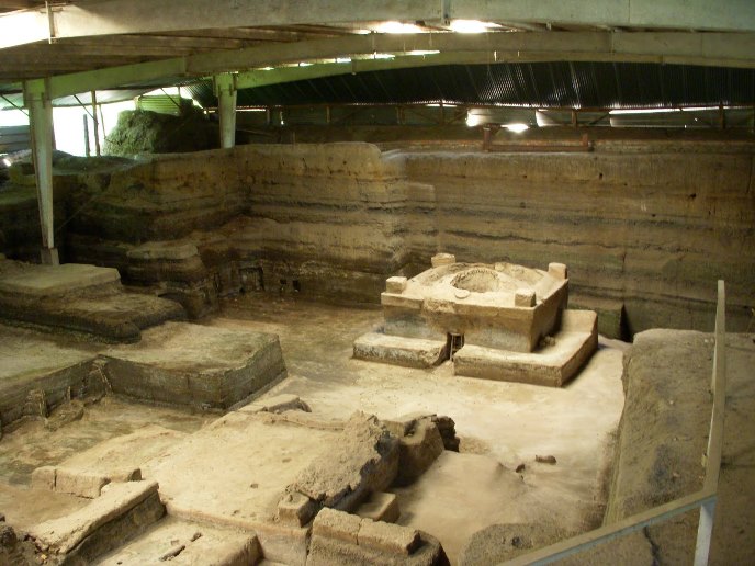
Excavation of Mayan settlement of Ceren. Note layered volcanic debris in the background
Dull, et al estimate that the erupted magma volume of the Ilopango eruption was at least 20% larger than Tambora but were unable to constrain the amount of SO2 ejected during the eruption. They conclude that Ilopango was large enough to cause the 535 AD dust veil but not sufficient to explain the entire 14 yearlong cold period in the northern hemisphere starting then.
Conclusions
This detective story continues, as the argument over which volcano triggered this climate shift continues. If Ilopango was so poorly dated right up until publication only four years ago, might the Krakatau eruption a millennia and a half ago be similarly poorly dated? Answer to that is: absolutely. Researchers believe they know one of the participants. They do not know how many more if any there are.
The other thing interesting to me is the difficulty of dating even relatively recent massive volcanic events. If you think about it, Ilopango eruptive products ought to be terrible to sort out and date, with some 22 other vents including seven other calderas within 150 km of its location. The only thing that makes it relatively straightforward is a significant chemical composition of the ash and the massive amount of it close to the volcano.

San Salvador city from space. Ilopango is at right. San Salvador at center. San Salvador volcanic complex to the left. Coatepeque Caldera is at far left
Additional Reading
http://www.volcanodiscovery.com/ilopango.html
https://gsa.confex.com/gsa/2012AM/webprogram/Paper211692.html
http://www.fundar.org.sv/Noticias/e_noticias_fundar_otras.html
http://geotop.uqam.ca/pdf/stixJ/Richer_et_al_GSASP_2004.pdf
http://specialpapers.gsapubs.org/content/412/1/F1.expansion.html
http://plate-tectonic.narod.ru/volcanoam13aaaaphotoalbum.html
http://flickrhivemind.net/Tags/ilopango/Interesting
https://www.sciencedirect.com/science/article/abs/pii/S0277379119301465


Interesting paper out of AGU100. A 10-year study of earthquakes in southern California > M4 2008 – 2017 found 72% of them were preceded by a foreshock sequence, which may end up being a vehicle we can use to predict the larger quakes. OTOH, figuring out what a foreshock is another thing entirely. H/T LA Times via Instapundit. Cheers –
https://agupubs.onlinelibrary.wiley.com/doi/10.1029/2019GL083725
LikeLike
Meanwhile in Peru: Ubinas volcano, which had produced phreatic eruptions during the last years, has now a magma body creeping up that causes some concern to the authorities. As there haven’t been any eruptions lately, the conduit seems to be bottled up. Volcanologists are now warning of a possibly strong eruption, where the lava could break out either from the crater or any place. They are quite concerned about possible flank eruptions. Yesterday a first (moderate) ashy explosion from the crater opened the game.
Sentinel-2 image (Sentinel Hub EO Browser), 18.08.2019, false colour (urban); shows the measured thermal anomalies from a near-surface magma body
LikeLike
And while everyone is waiting for a magmatic eruption from Ubinas, it’s actually Sabancaya that has revved up its seismic activity:
LikeLike
Another pumice raft in the Tonga – Kermadec region. We covered one last year. Cheers –
https://www.bbc.com/news/world-australia-49469446?fbclid=IwAR1UnB27kDI5hN3lBWccoxa3UWT1able1n5AM2NXbxnc6_VGWhrMyyzrsNk
LikeLike
New post is up! 🙂
LikeLike
Ilopango cannot be possibly responsible for the 536 sulfate signal but it is indeed the strongest candidate for the 541 signal.
536 signal is only limited to Northern Hemisphere and cannot be attributed to a tropical eruption. Rather, 541 signal is distributed more evenly in both hemispheres.
Recently, Kuwae caldera is ruled out to be the source of the 1453(Greenland)/1459(Antarctica) sulfate deposition based on glass composition from Antarctica ice-core, and the cooling and distribution of aerosol are likely only limited to Northern Hemisphere. The study has been submitted to Nature Geoscience: https://digitalcommons.library.umaine.edu/cgi/viewcontent.cgi?article=4089&context=etd
LikeLike
Thanks for the additional information. We looked at Kuwae in 2015. Looks to me like we need more information to pin the first eruption on it.
If the 536 AD signal was primarily northern Hemisphere, you quickly run out of locations for massive eruptions – Philippines, Indonesia, Central America and Mexico, Pacific Islands, Japan, Kamchatka, Iceland? Go too far north and you end up like we did with Baekdu / Paekdu – massive eruption with lots of ejecta that doesn’t travel far enough south to impact global temps. Interesting detective story, though. Cheers –
LikeLike
The Antarctica ice-cores do not record the 536 AD signal which appears only in the Greenland ice-cores. Tree-ring reconstruction of 536 AD cooling is also from northern Hemisphere.
The source of 536 AD signal might not be a single massive eruption but multiple eruptions around the globe. Based on the glass compositions from that level, at least three distinct compositions (All belong to west coast of North America) of tephras were erupted during that year.
Sigl et al (2015)
LikeLike
The coolings and sulfate signals in 1450s AD are elusive. In Antarctica, ice-cores record only one but it is an extremely powerful one with various timings from 1450-1460 AD in different cores. In Greenland, ice-cores record two separate strong sulfate depositions in 1453 AD and 1459 AD.
It is hard correlate the Antarctica sulfate spike with either 1453 or 1459 AD recorded in Greenland, and whether the Antarctica spike is bipolar at all still remains to be a question.
The highly variable magnitude and timing of the Antarctica sulfate peak favors rather a regional Antarctic eruption without hemispherical effect.
In fact, climate reconstructions from the entire northern hemisphere only show significant drop in temperature in 1453 AD.
The best inference we can make at this point is that there is a significant volcanic eruption in northern hemisphere in 1452 AD with cooling and aerosol largely limited to northern hemisphere. The sulfate spike in Antarctica is most likely due to a regional eruption and does not have global effects. The compositions of the tephras from the Antarctica sulfate layer does not match with those from Kuwae either, therefore excluding Kuwae as the source of sulfate. The 1450s sulfate signals are unlikely to be bipolar.
As you have explored before, the inland eruptive deposits of Kuwae do not indicate a power subaerial eruption.
LikeLike
The caption to the “San Salvador city from space” picture states that “Loma Caldera is at far left”. That is incorrect. It is Lake Coatepeque, a large crater lake in the east part of the Coatepeque Caldera. You can locate Loma Caldera with this link: https://goo.gl/maps/JU6k8WwNV5PTMQsU6.
LikeLike
Good catch. Many thanks for the correction. What a busy locale, calderas everywhere you look, and Loma is little more than a crater lake. Made the correction. Thank you for reading our content. Cheers –
LikeLike
Check out the almost straight line formed by the “Plan de La Laguna” maar (https://goo.gl/maps/aURsKdghez4V7W8Q7), the “Cerro La Hoya” crater (https://goo.gl/maps/mN892hAkpheWshgo9), the San Salvador Volcano crater (https://goo.gl/maps/uN8pWqMXuViuAkpJ6), the “Laguna Chanmico” maar (https://goo.gl/maps/fRjWSDzK3RMjU84v8), the “Boca del Jabalí” crater (https://goo.gl/maps/PexR2Hambd7penQAA), the “El Playón” cinder cone (https://goo.gl/maps/qVAZzmyPMLfdogFJ8), and the “Loma Caldera” maar (https://goo.gl/maps/JU6k8WwNV5PTMQsU6). Interesting, and terrifying.
LikeLike
Pingback: The Tecapa – San Miguel Volcanic Cluster, El Salvador |