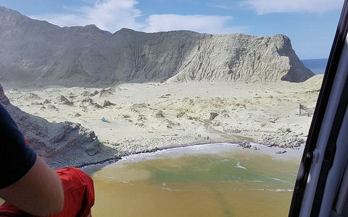
White Island from helo Dec 10, the day after the eruption. Note the new cover of ash, residual steam from the crater, and the significant outflow of mud into the surrounding ocean. Image courtesy RNZ.co
Sometimes events get your attention. I had been thinking about White Island off and on since finishing a post on Ruapehu early Dec 2019. Awoke to the news that there had been an eruption on White Island Dec 9, overnight for those of us in Alaska.
This eruption was particularly deadly, as White Island is both an active volcano and an active tourist destination. Initial reports were around 50 people on the island at the time of the eruption and perhaps up to 100 total in its vicinity. As of this writing, there are at least 16 deceased, 8 missing, over 23 with terrible burns, and some unknown number unaccounted for.

Initial phase of the Dec 9 eruption from a tour boat to the north of the island. Note the significant involvement of steam in the eruption. Grey is ash and previously erupted material. Video from this boat is embedded later in this post. Image courtesy Mirror.uk, Dec 11, 2019
The eruption was well covered by the international press, multiple FaceBook posts, articles in Watts Up With That by Eric Worral and David Middleton, and a short workup by Albert at the new Volcano Café. None of this includes the avalanche of Twitter activity. Search Twitter using #WhiteIsland and White Island terms.
The question then becomes: What can I add to the discussion? One answer would be to try a bit to put this into perspective.

Tourists on the Big Island of Hawaii observing lava from Kilauea flowing into the ocean in 2008. Photo by Leigh Hilbert / AP via The Star, May 2010
Volcano Tourism
A tragedy often triggers reactions. Normally, these are passionate, emotional with no small amount of good old-fashioned finger pointing, blame placing, second, third and twelfth guessing (hindsight being the only exact science), and most importantly a search for someone responsible (or not) to punish. This is the quintessential human reaction to something unexpected and awful.
The problem with this is that this reaction bumps right up against another basic human calling, that of risk taking. We humans take risk, some of us have more of a taste for it than others. Over time, this is how we improve ourselves and our situation in life. But it is a two-edged sword, for if you do it right, you improve something, anything, or simply get entertained. Do it recklessly and you run a very real risk of improving the gene pool by summarily removing yourself from it, hence the Darwin Awards. And it is that risk taking that gets some of us in trouble from time to time.

Volcano tourists at mining site on White Island April 2019. Image courtesy Kimberley Collins, Wikimedia Commons via WSWS.org, Dec 10, 2019
VH correspondent and occasional contributor Bruce Stout was in New Zealand at the time of the eruption. He wrote a few comments in the Volcanoes of Io Part 2 post in December that helped put some of this in perspective. First, everyone who goes to White Island as part of a commercial tour signs a paper acknowledging the risk. Second, these tours have been going on for years at varying levels of volcanic concern, including Level 2. He told us he visited the island some years ago.
Volcano tourism is generally a benign activity, with minimal risk. But minimal risk does not mean zero risk. Brown et al published a 2017 paper, Volcanic fatalities database: analysis of volcanic threat with distance and victim classification in the Journal of Applied Volcanology. The paper expands a volcano fatalities database to include all data from 1500 – 2017. It contains 635 records with over 278,000 fatalities. Data include distance from the volcano for 72% of the fatal incidents. Different mechanisms operate at different distances with ballistics responsible for most fatalities close and up to 5 km from the vent. Pyroclastic density currents (pyroclastic flows) operate 5 – 15 km. And lahars, tsunami and tephra falls dominate the record beyond 15 km.

Recovery operation on White Island Dec 13, 2019. Photo courtesy CNN, Dec 13, 2019
In this database, the most fatalities are local residents living close to the volcanoes. Tourists are next with 113 incidents and 561 fatalities, scientists in 22 incidents and 67 fatalities, miners in 6 incidents with 108 fatalities, media in 6 incidents with 30 fatalities, and emergency responders in 5 incidents with 57 fatalities. Clearly, we do this a lot.
The people who got hurt at White Island were engaging in volcano tourism. The next most recent deadly unexpected event was a phreatic eruption with a smallish pyroclastic flow at Mount Ontake in Japan Sept 27, 2014 which killed 63 of the hundreds on the mountain at the time. While earthquake levels may have been slightly elevated, JMA did not issue an alert. Kaneko, et al published a 2016 paper 2014 Mount Ontake eruption: characteristics of the phreatic eruption as inferred from aerial observations that is a pretty good description of what happened.

New White Island Tours excursion boat. Image courtesy Rotorua now, April 2019
Six scientists and three tourists were killed in Jan 1993 by a small explosion in the crater of Galeras. Mount Unzen killed Katia and Maurice Krafft with a pyroclastic flow in June 1991. Yellowstone has taken 23 lives since 1890, with 9 of them under the age of 10, mostly due to immersion in the thermal pools. Only two of these have taken place over the last 30 years. The deadliest eruption for scientists took place in 1952 at Myojin-sho at the Bayonnaise Rocks, sinking a boat observing its submarine eruption, killing all 31 onboard.
Volcanoes are clearly dangerous. And we know they are dangerous. The problem is that some explosions and blasts, especially phreatic ones give very little if any warning. White Island and Ontake are the most recent examples.
Even the experts get unlucky from time to time. Is this a reason to stop visiting them completely? For some of us, perhaps, though it depends on your personal relationship with risk. For others, not really, though getting better informed before making such a visit is probably a positive lifestyle choice. Informed decisions tend to be better decisions.
Somewhere along the line, local, regional, national governments and lawyers will get themselves involved in this process, typically after someone gets hurt. While that has not played out yet, it is only a matter of time with White Island. For his part, Bruce Stout suggested that perhaps children not be allowed on White Island any more and the total number of people on and around the island at any single time be limited so as not to overload rescue and recovery capability.

White island before eruption. Note the substantial crater lake in the crater and lack of crater wall to the east. Image courtesy Get Your Guide Bay of Plenty
White Island
White Island, also known by its Maori name Whakaari is an uninhabited 2 x 2.4 km island about 50 km north of the coast of North Island, New Zealand. It is one of the most active volcanoes in NZ and has a thriving tourist industry.
The island is the summit of a 16 x 18 km diameter submarine volcano in the Bay of Plenty. It is constructed by two overlapping andesitic to dacitic cones. The main crater is breached to the SE, which has become the preferential path for eruptive products. The floor of the crater is close to sea level and the breach allows significant subsurface sea water access to the crater, which in turn increases the possibility of phreatic / hydrophreatic eruptions and steam explosions in addition to those that produce ash.
Volckner Rocks are the remnants of a lava dome 5 km NNE.
The volcano tops out 321 m above the sea with the local sea floor 900 m below sea level.

Ruins of 1923 – 1933 mining operation in White Island. Image courtesy Photovolcanica
Nobody lives within 50 km of the volcano. Over 190,000 live on North Island within 100 km of the island. The island is privately owned, and visitors cannot land without permission. It is accessible by authorized tour operators. There is a small charter fleet that offers day and overnight trips for saltwater fishing in the bay and waters around the island.
White Island has been particularly deadly over the years, with a debris avalanche that buried a sulfur mining operation in 1914, killing 10. The 1914 avalanche was not volcanically related, though likely due to hydrothermal weakening of volcanic rocks in the crater wall that collapsed making the steep walls unstable. It has been nearly continuously active since its discovery by Captain Cook in 1769. It was in continuous eruption 1975 – 2000 with other eruptions in 2012, 2016 and 2019.

Map of location of White Island in the Bay of Plenty north of North Island, NZ. Image courtesy Cruzely, Dec 9, 2019
GeoNet, Geological hazard information for New Zealand monitors volcanic activity in the nation and has listed the activity level on White Island at Level 2 – 3 over the current eruptive cycle.
The Dec 9 eruption took out two webcams in the island. GeoNet still monitors it via offshore webcam and webicorders. Volcano Discovery also has access to the GeoNet monitoring feeds on its web site.
Over 10,000 people visit the island every year.
Dec 9, 2019 Phreatic Eruption
The AGU 100 Blogosphere Magma Cum Laude blog on Dec 12 had a pretty good compilation of the eruption and its immediate aftermath. The following mostly comes from this site.
The eruption took place at 1411 L and was 1 – 2 minutes long. It impacted mostly the crater floor, putting an ash and steam column 3 – 4 km above the island and covering the floor with new ash and debris. There was at least on helicopter on the crater floor that was destroyed and a photo of at least 8 tourists hiking across the crater floor taken shortly before the eruption.
Volcanic Alert Level was raised from 1 to 2 Nov 18 due to heightened activity on the island. It remains at Level 3 (minor volcanic eruption) and was raised to Level 4 (moderate volcanic eruption) during the eruption.
People on the island ran from the vicinity of the crater, seeking shelter in the ocean. Most were badly burned by the steam and ash. Tour operators immediately began recovering people from the island. Tour operators on the mainland launched helos and boats to assist in the effort. Law enforcement shortly shut down all public access to the island, which may have permanently halted all recovery efforts for those missing in the crater. As of this writing it is doubtful they will be recovered as the volcano remains in a heightened level of activity and additional explosions are expected.
GeoNet update #1 On Dec 9 confirmed 47 on the island at the time of the eruption, with 5 deceased, 8 missing, and 31 in hospitals with burns and other injuries.
GeoNet update #3 on Dec 10 reported no substantive change n activity level. Seismic activity remains weak and there was no further eruptive activity. GeoNet sampled airborne gas around the volcano and observed steam and gas from the active vent.

Guide on dock shortly after eruption. He was praised for “superhuman” efforts in rescuing those caught in the eruption. Image courtesy Michael Schade, NewsComAu, Dec 2019
GeoNet update #5 on 11 Dec documented volcanic tremor continuing and a medium likelihood of future eruptive activity within 24 hours. Shallow magma within the volcano is thought to be driving tremor, gas flux and steam jets from the crater observed during the eruption.
VH correspondent Bruce Stout writes that locals expect additional activity and there is some worry that the Dec 9 may be the beginning of something larger rather than a one off. Local law enforcement has shut down all civilian access to the island until activity settles down.
Lead-in to this eruption may have started as early as July 2019 with earthquake swarms, small scale geyser eruptions of mud and dteam in late Sept, increased SO2 and volcanic tremor in late Oct. SO2 emissions levels increased and tremor increased to moderate levels by mid-Nov, leading to GeoNet to raise its alert level to 2.

Undated photo of White Island looking north. Image courtesy KidsNews Dec 9, 2019
Volcano
Whakaari / White Island is currently New Zealand’s most active volcano, the north easternmost of the Taupo Volcanic Zone (TVZ). It is a wet volcano with a crater lake and typically explosive eruptions. These eruptions occur with little to no warning and generally occur in the main crater floor. They eject ballistics, ash, steam and pyroclastic surges. AGU volcanologists do not believe new magma is directly involved in most phreatic eruptions.
Its current eruptive style is frequent, small phreatic and phreatomagmatic eruptions, with mud eruptions and seismic activity. Distribution of seismic activity appears to be controlled by thermal and mechanical stresses and the reduction in the overall strength of volcanic rocks due to circulation of reactive hydrothermal fluids.

Crater lake and crater of White Island taken during a Feb 2019 tour. Note the steam from the hot, acidic water, yellow of hydrothermally altered crater wall rock. Image courtesy Stuff.co.nz, Dec 13, 2019
White Island has been active for more than 150,000 years and has a total volume of 78 km3. It erupts andesites and dacites. Lava plugs of Volkner Rocks and Club Rocks to the NW and S of White Island may be remnant parts of a third older cone that is older than the current two. There are seafloor hot springs 13 km to the south of White Island. There may be other seafloor vents in the deeper seafloor to the north of the island.
The present White Island complex is constructed of two overlapping cones, the older Ngatoro and younger Central cones. Remnants of the older cone form the western portion of the island. The younger cone overlaps the older cone and is formed of lava flows, breccias, unconsolidated beds of ash, tuff and masses of lava and agglomerates. The history of this volcano has been periods of cone building followed by long periods of quiet. There are unpublished data from 1999 suggesting that major episodes of lava extrusion are separated by 500 – 1,500 years.
The island has an active and vigorous hydrothermal system with multiple hot springs, mud pools, fumaroles, acid streams and lakes. The crater lake is the present center for volcanic activity and outgassing. It is acidic and hot. Extensive hydrothermal activity altered rocks, significantly weakening them compared with fresher lavas.

Tourists on the crater floor of White Island shortly before Dec 9 eruption. Image courtesy GeoNet via Forbes, Dec 8, 2019
White Island does not appear to have produced widely dispersed tephras. The oldest primary deposit found by sea floor drilling is dated at around 21,000 years ago. It was constructed by multiple small volume of andesite – dacite lava flows and pyroclastic deposits. Minor basaltic andesite explosive eruptions may have occurred throughout the history of the island but are rarely preserved. These alternate with major episodes of andesite – dacite lava extrusion.
The underlying magma source likely comes from dehydrating slab at the mantle – slab interface below the volcano. These magmas quickly rise to shallow magma chamber 2 – 7 km below the volcano where they undergo limited mixing and contamination before erupting. Some magmas remain in the chamber for a time and interact with the crystal mush present. Some magma slugs pass through the chamber quickly with little interaction or contamination. This mix of erupted magmas is thought to be like most andesite – dacite arc volcanoes.

Webicorder trace of Dec 9 eruption. Highlighted section is the duration of the eruption. Image courtesy GeoNet
Eruptions
Prior to the 2019 eruption, the most recent period of unrest was April 2016. The water level in the lake dropped by 2 m followed by a 90 min long eruption on April 27. There was a moderate increase in seismic activity after the eruption. The Activity Level was dropped from 3 to 2 after the eruption. Ash produced by this eruption was hydrothermally altered old rock with no juvenile magmas present. This eruption produced energetic blasts and surges. The lake level dropped at least 13 m and a partial collapse of crater walls. By Sept 2016 the crater lake was gone.
Unrest leading into the 2016 activity began in 2012 with plumes from the crater lake early August and an ash eruption two days later. Hydrothermal activity was vigorous with phreatic explosions and ash emissions through July 2013. There were larger explosions in August and October. The lake level continued to rise. A visit Feb 2014 found a fumarole inundated and geysering. There was a period of shallow earthquakes in late Aug 2014. Minor unrest continued through 2015 with ground deformation, tremor, changes in lake level, and gas emissions.

Schematic of plumbing system beneath White Island. Image courtesy Cole, et al, 2000
Activity 2007 – 2008 included variations in crater lake levels, new springs on the crater floor, steam plumes up to 3 km above the volcano, and changes in the lake temperature.
Activity in 2000 – 2001 included minor ash eruptions, noises, steam and ash emissions. These were not accompanied by any significant in seismic activity. These years marked the temporary end of near continuous activity since 1977. This activity included but was not limited to steam and ash explosions, inflation, deflation, new craters, change in active craters., changes in lake levels and temperatures and in some cases the lake disappearing completely, springs coming and going on the crater floor, mudflows, gas emissions and earthquakes.
Generally, eruptions on White Island are in the VEI 2 -3 range with the occasional VEI 1 in recent years.

Tectonics of North Island and New Zealand. Image courtesy Wallace, et al, 2004
Tectonics
White Island sits offshore the North Island of New Zealand in the northern segment of the Taupo Volcanic Zone (TVZ). This zone is the penetration of the Harve Trough, spreading region southward into North Island.
Basic tectonics in the northern part of New Zealand is driven by the subduction of the Pacific Plate under the Australian Plate. The line of subduction is offshore to the east as the Hikurangi – Kermadec Trough. Rate of subduction along this trough is 45 mm/year to the north of North Island. This transitions to a strike-slip motion as the line of impact bends northward through the northern part of South Island as the trough transitions to the Alpine Fault. Further complicating the subduction is the impingement of the Hikurangi Plateau, a segment of the larger Ontong – Java Plateau (Large Igneous Province) which has locked subduction south of North Island.

Block diagram of North Island, NZ. Penetration of Havre Trough into North Island is taking place just to the west of the Axial Ranges block. Image courtesy Wallace, et al, 2004
The TVZ has been opening for the last 2 – 4 Ma as the Havre Trough has penetrated southward into North Island. Rates of opening have varied from a few mm/year in the southern portion (Ruapehu) to over 20 mm/year offshore to the north of North Island. It is this extension that allows magmas to more easily reach the surface. This magma movement powers stratovolcano activity in the southern portion of the TVZ, significant silicic volcanism and caldera formation in the central portion, and multiple andesitic offshore volcanism north of the Island.
North Island and offshore to the east are divided into multiple blocks. Three of them, Raukumara, Central Hikurangi and Wairarapa are mostly offshore to the east and bounded by the Wallington Mohaka Fault system just onshore the eastern portion of North Island. The slender Axial Ranges block is immediately to the west of the fault line, running the length of the island north to south. The TVZ is to the immediate west of the Axial Ranges Block. Tectonic activity along the boundaries of these blocks is responsible for significant earthquake activity in North Island.

Dec 9 eruption from a tour boat leaving the island at a high rate of speed. Image courtesyNZ Police handout / EPA-EFE / Shutterstock via Travelandleisure.com, Dec 9, 2019
Conclusions
White Island and its surrounds are a vigorously active andesitic – dacite volcanic system. Due to its location and the open access to large quantities of sea water, it is a wet volcano with both a vigorous hydrothermal system and a substantial supply of magma. Over history, it has produced substantial lava flows and explosive eruptions. Our experience with White Island has been primarily hydrothermal activity and phreatic / phreatomagmatic eruptions, both of which make the ongoing tourist traffic of 10,000 people to the island yearly, sporty at best.
There is nothing tour operators can do to make the volcano any less dangerous. Perhaps the tragic events of Dec 9 will go a ways to make their visits somewhat less dangerous.

Tourists on White Island July 9, 2019. Image courtesy Hagen Hopkins / Getty via Business Insider, Dec 11, 2019
Additional information
https://www.facebook.com/groups/189749654542072/?ref=bookmarks
https://volcano.si.edu/volcano.cfm?vn=241040
https://www.geonet.org.nz/about/volcano/whiteisland
https://www.wired.com/2012/08/how-dangerous-is-visiting-white-island/
https://academic.oup.com/petrology/article/41/6/867/1587273
https://link.springer.com/article/10.1007/BF02597783
https://agupubs.onlinelibrary.wiley.com/doi/full/10.1029/2002TC001447
https://agupubs.onlinelibrary.wiley.com/doi/full/10.1029/2004jb003241
https://link.springer.com/article/10.1007/BF00268925
https://www.sciencedirect.com/science/article/pii/S037702731500058X
https://agupubs.onlinelibrary.wiley.com/doi/full/10.1029/2012JB009469


My wife and I visited Etna in 2001 and watched the volcanic bombs being blasted from the new vent and saw how the black Aa lava becomes red and alive at dusk. We were at White Island in spring 2016 and stood at the vent rim and peered in – – In 2017 we experienced a lava break out at kalapana Hawaii and took the boat to watch the lava pour into the sea. Just months later a boat had bombs thrown onto the deck and some were injured. Also guide and his party walking on the flows were over come by fumes when it rained and the wind changed he got the party out but sadly died him self we feel very lucky. Our thoughts are very much with those who lost their lives and were injured. I am a geologist –
LikeLike
It is a tough business, visiting things that occasionally remind us who or what are in charge. But it is all personal choices on how much risk to accept. Such choices backfire horribly from time to time. OTOH, the visitors are rewarded with access to spectacular venues which God will mostly allow us to depart unscathed. Prayers for the deceased and their families. Still, those who chose to go mostly knew what they were getting into and chose to do it anyway, the very definition of personal choice and freedom. Best to you and yours and thank you for your comment. Cheers –
LikeLike
Hi A. good write-up in my opinion about a tricky topic. I understand Graniya totally too, who was upset about the commercial aspect of volcano tourism knowing the elevated risk. I understand and respect that. The only thing I can say in return is that I have no issue with volcano tourism provided people know the risks and can weigh them up for themselves. You would still have to be pretty unlucky to get hit by a phreatic explosion, even on White Island, but risk is everywhere. I think people should be able to choose for themselves. As for the operators, they also put their lives on the line, and due to repeated tours that risk is more than an entire degree of magnitude higher than the risks posed to tourists. All I have heard from them is that they love and respect the place and know what they are doing. Forgotten I had said that about banning children, but in retrospect I stand by it. /sorry, didn’t realise I had to log into WordPress again. Bruce
LikeLike
Thank you for your comment. My background is aerospace. I understand risk, especially the knowing what you are getting into part of risk. The people who are generally in the risk-tourism, extreme sports, other forms of higher than normal risk endeavors or pursuits, usually have significant respect (and love) for the thing they are doing and introducing others to. We are on the verge of seeing this take place with commercial space travel. There will be accidents and people who won’t return, and we all know it. Doesn’t mean that it won’t happen. The suborbital guys are pretty close to starting commercial flights. SpaceX has been talking about a circumlunar commercial flight in the next year or two (Apollo 13 trajectory) for a few years. These are not low risk endeavors and should be celebrated. Best to you and yours. Cheers –
LikeLike
Very good post, agimarc! I agree with all you say, there is only one thing you entirely forgot to mention: Money! The formula
Admit heightened risk at a certain time = less tourists = loss of profit
is as true for volcano tour operators as for any other business in the world. Where Money is concerned love, experience, courage, foresight, caution or reason doesn’t count.
That is what a regulation is needed for – the commercial aspect of it. Not for the risk every visitor signs up for. The risk will not go away, but can be minimized to a reasonable level.
—
As of November 30, 13 parties are facing criminal charges in connection with the eruption. Among them, sadly, the GNS Science. This is so wrong in my view: they did raise the alert level to Unrest a few days earlier. The responsibility lies solely by the tour operator, who has eyes to see what there is to see on the seismogram. He is not asked to expertly interpret the seismogram. He is asked to make a reasonable decision to protect people as good as he can.
Here is what Shane Cronin had to say about it last week, though:
https://theconversation.com/scientists-should-welcome-charges-against-agency-over-whakaari-white-island-if-it-helps-improve-early-warning-systems-151174
Also this about a new early warning system, from July:
https://theconversation.com/new-zealands-white-island-is-likely-to-erupt-violently-again-but-a-new-alert-system-could-give-hours-of-warning-and-save-lives-142656
LikeLike
Thanks, Granyia for your comments. I think we mostly agree, with whatever money is in play applied on either (both?) side(s) based on risk is implied, accepted, asked to be accepted, any, or all 3. In this, I think the ticket price, whatever it is, defines what people on either side of the equation are willing to do. If things are too exciting or risky, there is no ticket price that will be high enough or low enough. The alternate also holds true . Of course, once something awful happens, 20-20 Hindsight kicks in as does the finger pointing and official placing of the blame which changes the game completely. As always, what is reasonable is in the eyes of the beholder, customer, vendor, insurer or regulator. Governments and insurers will tend to minimize risk, tour operators will end up being driven more by the marketplace and their customers. And if they are either predatory or reckless, they will be quickly put out of business by the regulators / insurers.
Sad at GNS science being targeted, as it is remindful of the Italian scientists targeted in lawsuits for not correctly predicting an earthquake.
Agree with your first link that this event will in the long run improve eruption forecasting. Skeptical that it will do so any time soon, but what do I know? Phreatic eruptions like this one burst out of the background noise quickly and violently and I am not yet convinced that anyone has a handle on that as yet. OTOH, every single event is a data gathering and data analysis gold mine, so over time, I do expect forecasting to improve. Think we get from here to there via an iterative process over an extended period of time rather than a bit flip. And that means we have some number of unpleasant future events.
Best to you and yours. Cheers –
LikeLike
new article in the Guardian today:
https://www.theguardian.com/world/2020/dec/15/white-island-whakaari-volcano-ardern-urged-to-help-rescue-pilots-facing-charges
It is not very clearly written because it suggests the helicopter pilot is getting fined for saving people on an unauthorised rescue mission but as I understand it, he is getting fined for not running his business safely.
I can understand the charges against tour operators (though I don’t agree with them) but charging Geonet is an outrage. It is paramount that scientists can do their job without being subject to the forces of public opinion and liability for the decisions of others. I hope the court upholds this view.
LikeLike
Just read Shane Cronin’s piece on it. This is an interesting take on it but, unless I am reading him wrong, he also thinks the science agencies should not be held culpable by the courts. I don’t know where he got the stat that there was a 10% chance of an eruption in 48 hours. That is the first I have heard of it and sure, a risk of that level should lead to an immediate no-go zone. No argument.
As for the issue of culpability, we discussed that once with regard to the earthquake in Aquila, as you point out, and I guess the same holds true here. The best path forward is open, clear and honest communication. The public and most of all, the decision makers (tour operators, tourists in this case) should have the best information available to make an informed decision. Government agencies (including science agencies like Geonet) should see public outreach as an equally important part of their job as doing the basic research. This means making sure people understand both the limits of knowledge as well as having the latest information quickly available. A good example are the tsunami warning systems and public outreach after the Tohoku tsunami.
As for businesses engaged in adventure tourism, I do appreciate that money can compromise things, but none of the guys I know doing this kind of thing want anyone hurt. Not only would that be really bad for business, it is also just part of their professionalism. Reminds of Rob Hall, a Kiwi guide who died on Mt. Everest because he wouldn’t leave his client. So, no, I don’t think these guys are essentially corrupt or pursuing the sole motive of making a buck. They are basically just doing, what they love doing and letting others share in it.
So, I guess what I am saying is two things.
1. Informed knowledgeable individuals should be free to do what they choose to do (as long as they don’t put others at risk in the process)
2. Government agencies should be given the resources to ensure the best information is available to facilitate decisions by the individuals referred to in 1.
LikeLike
If the courts allow this, they’re gonna end up with nobody willing to predict, much less monitor anything and nobody willing to do a rescue or recovery effort. The road to a very hot place continues to be paved with good intentions.
Cold and snowy up here, but at least it’s dark. Happily, days start getting longer in a week. Yay!. Best wishes to one and all for the very merriest Christmas (or whatever other holiday celebration is applicable) for you and yours. Cheers –
LikeLike
Best wishes to you two, A. and also to Graniya. Hope all of you have a great Xmas and let’s all hope for a better year in 2021.
Really love your articles and appreciate the amount of work that goes into this place. It is a real gem.
LikeLike
As always, many thanks for your kind words. We are trying however poorly to describe what is going on and how it came to be. Sometimes it works. Sometimes it doesn’t. Still, the process continues to be sufficiently interesting to continue doing it. Best to you and yours. Cheers –
LikeLike