

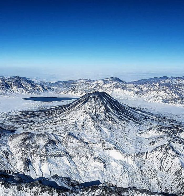
Maipo is a young, post-caldera 5,323 m stratovolcano built in the Diamante caldera straddling the Chile – Argentina border in the central Andes. It is located in the northern segment of the Andean Southern Volcanic Zone, 180 km north E of previously covered Descabazado Grande, Quizapu, Cerro Azul volcanoes and the associated Calabozos Caldera.
Insert link to this post

The region around Maipo / Diamante is sparsely populated, with just over 8,000 within 30 km. There are nearly 1.7 million within 100 km, most of them in Santiago 110 km NW.
While remote, the area does have a thriving hiking and climbing industry, with Maipo considered as one of the easier 5,000 climbs in the Andes. This doesn’t mean that it is not in itself challenging. Package deals range from a challenging 11 hour round trip from base camp on the SW shore of Laguna Diamante to a 6-day long trek from Mendoza to the E to the summit of Maipo. Interestingly, charges for descent and return to Mendoza are not listed. Hikers are urged to dress for warmth due to the possible low temperatures at altitude.

As Maipo / Diamante lies on the Argentine – Chilean border, on the Andes, the two closest regions are Mendoza Province in Argentina to the E and the Central Valley of Chile to the immediate W. Temperatures in this part of the world are altitude dependent, cold up high. Winds are common.

Mendoza Province has 1.7 million residents. Its capital and largest city is Mendoza, 165 km NE, with a population just over a million people. Elevation is generally 875 m. Climate is continental, sunny and dry, with warm summers and relatively cold winters. It is a mostly dry province, with annual precipitation 15 – 35 cm. As the province is mostly in the Andean rain shadow, rain increases closer to the border of Chile. The province is the center of Argentinian win production. Other economic drivers are agriculture and mining with a growing tourist flow.
The Chilean Central Valley is the agricultural heartland of Chile. It has a Mediterranean climate with cool, dry summers and mild, rainy winters.
Volcanoes in this part of Chile are monitored by the Southern Andean Volcano Observatory, Observatorio Volcanologico de los Andes del Sur (OVDAS), part of Servicio Nacional de Geologia y Mineria. As far as I can tell, neither Maipo nor Diamante are monitored in real time. Volcanoes in Argentina are monitored by Servicio Geologico Minero Argentino (SegemAR). The Argentine side does have a page for Maipo / Diamante. Ash emissions in this part of the world are monitored by VAAC Buenos Aires.

Region
Caldera del Atuel is located 18 km SSW of the rim of Diamante caldera. Rio del Atuel drains SW though a breach in the caldera wall. There are at least 15 dacite lava domes and 25 basaltic andesite to andesite stratovolcanoes and cinder cones on the caldera floor. Las Lagrimas is a group of cones on the SW rim of the caldera. Volcan Guanagueros in the NE flank of the caldera is a group of recent cinder cones. Volcan Overo complex is located on the NE part of the caldera. Volcano Sosneado complex on the SE part of the caldera has numerous young pyroclastic cones and lava flows. There are over 20 eruptive centers, with lava flows covering over 200 km2.

Planchon – Peteroa is another caldera complex 137 km SW from Maipo, 42 km NNE of the Calabozos caldera complex. It contains several overlapping calderas. This system is relatively new, with the construction of Volcan Azuifre, followed by Volcano Planchon 6 km N. Much of Azufre and part of Planchon collapsed 11.5 ka, forming the Rio Teno debris avalanche, which traveled 95 km into Chile’s central valley. After the collapse, Volcan Planchon II built. The youngest system, Volcan Pereroa is multiple vents between Azufre and Planchon. It has been active in historic times with a small crater lake. Eruptions are generally explosive with at least two lava flows.

San Jose, 45 km N of Maipo is located at the southern end of a volcanic group that includes Volcan Marmolejo and Espiritu Santo. The glaciated Marmolejo is truncated by a 4 km caldera, breached to the NW, source of a massive debris avalanche. San Jose is topped with a 0.5 x 2.0 km region with overlapping and nested craters, pyroclastic cones, and blocky lava flows. Closely neighboring Volcan la Engoda and Volcan Platat are located between Marmolejo and San Jose. Both have been active during the Holocene. Mild phreatic eruptions took place at San Jose during the last two centuries.

Tupungaitito located 83 km N is the northernmost historically active volcano of the Chilian central Andes. It is a group of 12 Holocene andesitic, basaltic craters and a pyroclastic cone on the NW end of a 4 km wide caldera, Nevado Sin Nombre. The caldera is filled with glaciers at its southern end. It is breached to the NW. Lava flows from the northernmost vent traveled down the NW flank breach. It has multiple mild explosive eruptions during the last two centuries.

Diamante Caldera
Pre-caldera activity built several local stratovolcanoes starting at least 5 Ma. At least three of these are located near the caldera, Listado, Picos del Barroso and Cerro Castillo. These produced lava flows, ignimbrites and lahar deposits.
Pre-caldera rocks exposed on the E wall of the caldera include a stack of andesitic lavas, ignimbrites, lahars and intrusive dikes. The lower portion of this stack is cut by dikes. The S wall has a stack of intermediate lavas, intrusive rocks, sandstones and sediments. There is a large, pre-caldera silicic intrusion and several smaller rhyolite dikes. The intrusion was altered, though not hydrothermally. Andesitic lavas ring the caldera and cover basement rocks. They are best preserved on the W and S margins, where stacks of numerous andesite flows are 100 – 300 m thick. These flows are 10 – 70 m thick and interlayered with flow breccias, lahars and other wet deposits. Pre-caldera lavas on the N side are much thinner.

The 20 x 16 km Diamante caldera formed is a massive VEI 7.7 eruption some 450 ka. The eruption produced 270 – 350 km3 of rhyolites. Some estimates range up to 450 km3. The ignimbrites traveled down and filled river valleys as far as 150 km from the caldera. It created a widespread pyroclastic plain in the northern foothills of Mendoza. Outcrops of the tuff to the S disappear under modern glacial gravel deposits. Total coverage is estimated at 15,000 km2 before erosion and burial under glacial deposits. The westernmost outcrops of the flow are 10 – 20 m thick. Those near Santiago are at least 30 m thick, 110 km NW.
The Diamante Tuff is a widespread tuff stretching from Santiago to the W and well into Argentina to the E. It is mostly non to moderately welded. The tuff dammed the Rio Yaucha to at least 700 m. It may have had a low temperature when deposited. The eruptive column may have been extremely high, cooling the pyroclastics before they were deposited on column collapse. This also provides a mechanism for large volumes of material to cross substantial barriers to flow between the source and the farthest coverage. The tuff is lithic rich near the source, with little at its farthest reach. Near the source, lithics are at least 15% of the total volume of the tuff.
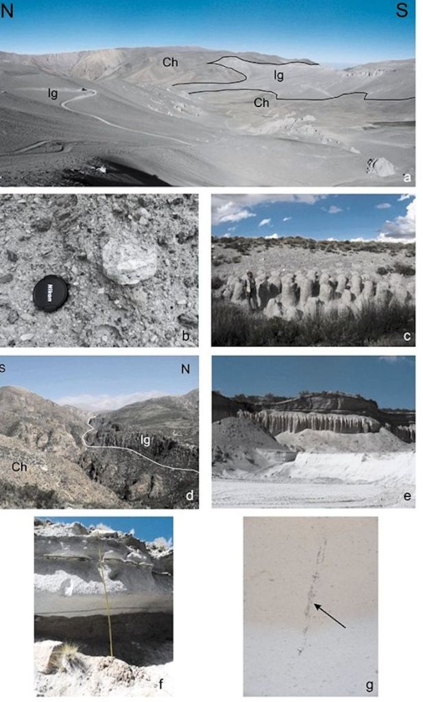
Thickness varies from less than 100 m near the caldera rim to over 700 m 3 km E of the caldera. The tuff flow ponded at a narrow point in a valley. In the central valley of Chile and on the foothills E of the cordillera, it is 100 – 150 m thick. There is no evidence of more than a single eruption associated with formation of the caldera. The tuff is dated around 450 ka, with an error of 60 ka either side of that date, though recent paper suggest that eruption might have been as recent as 150 ka. The scientific discussion to reconcile the eruption date is just beginning.
The initial eruption was explosive producing a pair of Plinian plumes. These two events took place in quick succession depositing at least 20 km3 of Plinian fall, the Lower and Upper Drop layers. There were no apparent large fluctuations in the height of the eruptive column during this part of the eruption. After depressurizing the shallow magma chamber located less than 7 km below the surface, it was immediately followed by massive ignimbrite flows. Caldera collapse was piecemeal, in discrete blocks. There are unsorted high energy base surge deposits along the E edge of the caldera.

Post caldera activity built Maipo, Dom Casimiro and Cerro Listado. Maipo is located inside the caldera proper. Dom Casimiro is a smallish andesitic stratovolcano on the SW rim of the Diamante caldera. Cerro Listado is on the SW flank of the caldera. Activity from Casimiro was initially dated around 28 ka, the end of the preglacial cycle of activity at Maipo. More recent analysis pushes that date back to concurrently with initial activity at Maipo, around 86 ka. They have chemically similar lavas.
Dating activity from this system has been difficult, with multiple ongoing arguments about eruption dates. One of the things that help conclusions is the date of the last glacial maximum, some 28 – 14 ka. If glacial debris is found on top of whatever was erupted, that material is dated older than the beginning of the last glacial.
Volcan Maipo
Maipo is a small, conical stratovolcano that straddles the Chile – Argentina border. It rises some 1,900 m above the caldera floor. Lavas from a 19th Century eruption dammed a local river creating the current Laguna del Diamante inside the caldera. This lake is ephemeral, having formed and discharged at least twice over the last 100 ka. There is permafrost on Maipo, stretching from the summit down to the 3,600 – 3,800 m level. Levels during the last ice age were as low as 3,400 – 3,500m, the foot of the southern slope of Maipo.
Maipo erupted relatively large volumes of magma via central vent lava eruptions, small volumes during post glacial activity, and a few poorly dated episodes in historic time. Its products are typically andesites, some rhyodacites, and small volumes of basalts and basaltic andesites. It is topped by two craters. The older one on the W side of the summit was cut by a new crater on the E. Several young lava flows on the S and E flanks were erupted from the newer crater.

Initial activity at Maipo 86 ka built an andesitic, basaltic andesitic shield. Subsequent activity built a small dome in the ring fracture on the N rim of the caldera. The magma source for the dacitic dome is estimated to come from 4 – 15 km deep. Around 45 ka, eruptive style at Maipo changed drastically, erupting pyroclastics along with lavas. This built a substantially steeper stratovolcano cone. Cone construction continued with lava flows and pyroclastics interlayered.
Before the beginning of the last glacial, 28 ka, lava flows spilled to the E, through flank vents like the 100 m tall Cerro Nicano. It is surrounded and partly covered by moraine deposits. It has a well-preserved central crater, notched by lava flows to the W.

In post-glacial times, activity returned to the central Maipo vent, erupting dacites from the eastern summit crater. These magmas also came from a magma chamber 4 – 15 km deep. Recent and historic activity has been Strombolian, with bombs, lapilli, ash and lava flows. These products are low volume andesites. Activity appears to cycle in recent years, with lava flows alternating with Strombolian explosions. This may be due to periodic injection of magma packets into the deeper magma storage, which in turn interacts with evolved fractionally crystallized shallow magma parcels.
The magma chamber is differentiated, fractionally crystalized, and magma injection does not trigger explosive eruptions. No phreatomagmatic eruptions are known to take place at Maipo. Magma has cooled, leading to formation of silicic domes and pyroclastic flows after dome collapse.

Maipo Eruptive Events
Activity at Maipo started around 100 ka, after a long (350 ka) quiet period following caldera formation. There have been seven eruptive episodes at Maipo over that time. Initial activity produced lava flows, building a shield. The oldest lava flows are andesites dated some 86 ka. They are poorly preserved and covered by a thin glacial deposit. The flows have also been scoured by glacial ice, showing polished surfaces and gouges.
The next event was construction of a small dacite dome on the N wall of the caldera. It is a kilometer in diameter, 150 m high. This was initially interpreted as a recent event. However, there are lateral moraines on its southern flanks, indicating a much older date, currently estimated at 75 ka. It is a small, isolated body with steep margins and vertical columnar jointing. The dome is currently unique, though there may be similar domes around the caldera ring faults that have yet to be discovered. There are other andesitic and rhyodacitic outcrops near the ring fracture that do not appear to be related to faulting, nor do they appear to be as young as the dome.

Eruptive Event III took place some 45 ka and built most of the volcanic cone. It was mostly pyroclastic, with andesitic and dacitic lavas interlayered with pyroclastics. This volcanic pile has been glacially eroded, more on the S and SE flanks, where glacial erosion is stronger. Total thickness is greater than 300 m, with thickness of individual flows highly variable 2 – 25 m. These flows were banded dacites.
Eruptive event IV 28 ka produced andesitic lava flows at the lower eastern flank. These lavas have high, steep flow fronts only partly covered by drift deposits. They are thought to be associated with a small parasitic scoria cone, C Nicanor, that has a central crater and a lateral outlet. These lavas look fresh and were originally attributed to an 1826 eruption. There is evidence of a lake that may be due to the final stages of ice melting at the end of the last glaciation. The partial coverage of the flows by glacial drift set the age of this activity 28 ka.

Eruptive event V is a prominent dacitic lava flow on the E flank of Maipo. The flow covers moraine deposits, meaning it is post glacial at less than 14 ka. The flow has steep levees. Eruptive event VI produced a short dacitic lava flow over an earlier post-glacial lava flow. It poured from the central vent and traveled along the central channel of the older lava flow. It is also dated less than 14 ka. The most recent eruptive event produced basaltic andesitic scorias around the summit of the main volcano. They may be connected to bomb fields over the SE flank and are likewise dated less than 14 ka.
The youngest flows are andesites erupted from a small parasitic cone on the E flank of the main volcano. It is well below the summit and 125 m high. These lavas dammed the Rio Diamamte, creating a large lake on the eastern floor of the caldera. The most recent activity was a thermal event on the SE flank the triggered a large mudflow. Rapid heating of the SE side of the volcano melted a portion of a glacier higher on the volcano that put a lahar a short distance away on the caldera floor.

Recent Activity
The Diamante caldera – Maipo volcano complex is somewhat of an odd duck, with a lack of hydrothermal or fumarole activity. Maipo’s summit craters are covered in ice. The system is suspiciously quiet compared with neighboring volcanic centers. Researchers have come up with different numbers of recent eruptions. One has only four historic eruptions from Maipo. Another includes at least 8 eruptions 1822 – 1913, and a probable event in 1931. The second researcher suggests that the only post-glacial activity was the ring fault dome rather than including the parasitic cone as that recent. The main difficulty continues to be identifying any conclusive evidence of historic activity.
Both lists of eruptions describe eruptions of lava flows, scoria cone construction, strong phreatomagmatic eruptions, tephras, fumaroles, avalanche and lahars.

Explosions and earthquakes heard / felt in Rancagua in 1905, were initially attributed to Maipo, 75 km from the city. The most reliable history of eruptions from Maipo are thought to be 1826, 1829, 1905 and 1912. Episodes 1822, 1831, 1833, 1835, 1837, 1869, 1881, 1908, and 1929 are uncertain. The final eruptive episode may correspond to the 1912 episode.
One of the things that make it difficult to build an accurate chronology of activity is the old name of neighboring Jan Jose volcano, which was formerly known as San Jose del Maipo. Maipo’s remote location and lack of visual witnesses make this more difficult.

Tectonics
The Diamante Caldera – Maipo Volcanic Complex is located at the northern section of the Andean Southern Volcanic Zone. Volcanic activity is driven by the subduction of the Nazca Plate beneath South America. The plate is descending 18 – 20° beneath the system. Convergence here is 9 – 11 cm/yr. Crust beneath the Andes here thins from 45 – 30 km. The thinning corresponds with a change from intermediate to basaltic volcanism east of the Andes. Volcanoes in this part of the Andes are on a basement 1,500 – 2,500 m above sea level on a crust about 40 km thick.
The Andean Southern Volcanic Zone (SVZ) is located just to the south of a non volcanic zone, between the Central and Southern volcanic Zones. It is divided into three segments: the northern section (NSVZ – 33 – 34.5°S), a transitional section (TSVZ – 34.5 – 37°S), and the southern section (SSVZ – 37 – 46°S). Th northern section has a thicker continental crust and more silicic magmas than the transitional (where Maipo is located) and the southern section. The Juan Fernandez Ridge is subducting in the southern part of the non volcanic zone.
The Diamante Caldera and Maipo volcanic complex is located between 3,300 m and 5,200 m (top of Maipo stratovolcano). It is built on the Andean crest, 300 km from the Peru – Chile trench, 90 – 110 km above the descending plate. It is located on top of folded Mesozoic marine and continental sediments interbedded with volcanic rocks.

Volcanism in the region has been driven by changes in the subduction angle of the Nazca Plate beneath the South American Plate. Oldest volcanism shows chemistry of a mantle wedge above a typical subducting slab. This changed 15 – 10 Ma when the erupted magmas shifted to a basaltic, andesitic, dacitic mix. This is thought to be related to a decrease in subduction angle to a more typical flat plate subduction. That didn’t last long, as the slab angle returned to its original and current angle 8 – 3.5 Ma.
Volcanic activity related to these changes created three lines of volcanic systems. The farthest east is a massive basaltic volcanic province called the Payenia volcanic field to the east of the Andean forelands. There are two additional lines of active volcanic systems today along the cordilleran spine. The central group is a line of rhyolitic calderas dating 2.5 – 0.15 Ma. To the immediate west, there is a line of quaternary volcanic centers (stratovolcanoes).

When the subduction angle steepened, a massive injection of hot mantle fluids led to basalt flooding in the forearc, covering over 40,000 km2 from more than 800 vents. This basalt province is unique in the eastern Andean foothills. The thin continental crust over this portion of the subduction appears to be the difference between the widespread caldera and ignimbrite flareup of the Altiplano (thicker crust) and the basalt flooding of Payenia (thinner crust).
The long record of massive silicic pyroclastic activity, the existence of multiple recent calderas in the 33° S – 36° S present a threat to multiple major cities near the mouths of Andean canyons to the west of the Cordillera. On the other hand, geothermal potential from long-lived silicic centers located 40 – 60 km from major population centers is an opportunity.
Conclusions
Activity at Maipo started as post caldera eruptions following the massive eruption that created the Daimante Tuff. It erupted significant amounts of andesites and dacites. Interestingly, it does not have anything appearing to be an active hydrothermal system, indicating injections of magma packets into magma storage are infrequent at best. While multiple eruptions took place at Maipo in the last two centuries, they were on the small side, alternating between effusive and explosive. The system is not currently monitored, but in relatively close proximity to other active volcanoes in this part of the Central Andes. Any future activity will announce itself via earthquakes large enough to be remotely sensed and plumes large enough to be seen visually or via satellite.

Additional information
Origin of magmatic components in the Diamante Tuff, Burkert, et al, Nov 2010
The influence of volcanism on Andean rivers, S Hynek, Vignettes


Contemporary volcanology, lets say of the 19th and 20th Century, has yet to witness a caldera-forming event, the aftermath and consequences of which have created many of the land formations described in many of your posts. Miles wide caldera and tuff deposits hundreds of feet thick?? Even ‘The Valley of the Ten Thousands Smokes’ and the ‘St Helens Volcanic Monument’ are mild compared to others. Not in our life times it seems. Just say’in……MMV.
LikeLike
Good point. While Tambora and Krakatau in the 19th century were really big, they didn’t create anything remotely as large as Diamante. The farther back we get from present day, the longer it takes to figure out what happened and the impact of those events. It took a while to figure out how large those two were.
Its been a busy century. Witnessed several flank collapse events in the 20th century: Bezymianny, St Helens and Krakatau, and have a better handle on what happened. Witnessed several lahar events, some of them quite deadly: Nevado del Ruiz. Witnessed several smaller caldera forming / caldera enlarging eruptions in the 20th: Katmai, Pinatubo and Hunga Tonga. Likely missed several of them.
These events are happily infrequent. But the more of them we see, the better we figure out what happened and why. Wondering if the Next Big Thing will be to understand what changes a run of the mill eruption (assuming such a thing exists) to something in the VEI 7 – 8 range that excavates miles wide calderas while depositing ignimbrites hundreds of meters thick. The good news is that these events are few and far between. The bad news is that they don’t play well with humanity.
Thanks for reading and your interesting thoughts. Cheers –
LikeLike
Well writ.
LikeLike
Third pulse of Iceland fissure eruption near Grindavik took place last night. Nice, albeit short video. Lava is apparently flowing over buried heating pipes in the town. Cheers –
LikeLike
It Appears that the Icelanders are rerouting the hot water supply around the blockage and expect to have the affected areas resupplied late February 9 From an article in the Iceland Monitor.
LikeLike