One of the fun things blogging about volcanoes is the discovery process. Invariably, when I decide to take a look at a single volcanic system or stratovolcano, I find other volcanoes in close proximity that may or may not be related. The process of finding how these systems came to be and are related to one another is fascinating and more times than not ends up with a post going directions other than my initial idea.
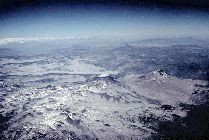
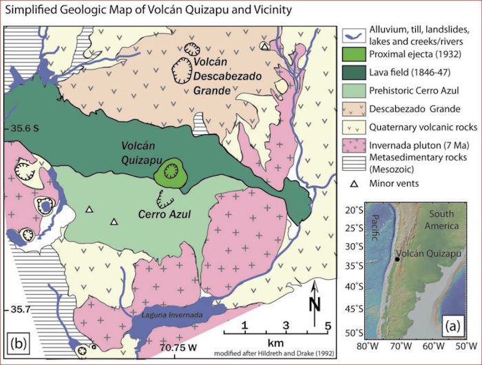
Such is the case with Descabezado Grande in the Maule region of Chile. Initially, this looked like a single stratovolcano with two relatively close vents (Cerro Azul and Quizapu) on its southern flank. As it turns out, the three vents are very close to one of the major calderas in the southern Andes, the Calabozos, measuring a whopping 14 x 26 km.

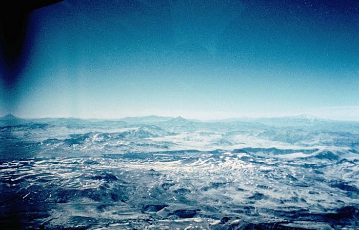
The entire volcanic complex is quite visible on satellite photography, having buried a couple hundred square kilometers of the southern Andes with thick ignimbrite sheets. As usual, erosion has done its best over the intervening eons to remove much of the soft volcanic material, sending it down river valleys, mostly to the west of the system.
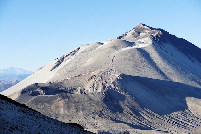
Descabezado Grande is the largest stratovolcano in the center of a 20 x 30 km volcanic field in the Maule region of Chile. It tops out at 3,953 m with a 1.4 km ice-filled caldera on the top. It is this caldera that leads to its name, as “descabezado” means “headless” in Spanish.

The volcano is andesitic with rhyodacite lava flows and pyroclastic flow deposits. The base diameter is 10 x 12 km with a volume of 30 km3. Its closest neighbor 7 km south is the Cerro Azul volcano. The Quizapu vent, site of two historic eruptions opened on a ridge connecting the two larger volcanoes. The volcano has active fumaroles.
We wrote about the Maule region Oct 2019 with a post on the 2007 – 2014 uplift episode at Laguna del Maule, and Nevados de Chillian Dec 2016. This is located in the Andean Transitional Southern Volcanic Zone (TSVZ).
This region is remote, with just over 3,000 people within 30 km. That number rises to 704,000 living within 100 km, mostly 84 km to the west on the coastal plain in Talca. The Altos de Lircay Resera Nacional and the Parque Nacional Radal Siete Tazas are on the Andean foothills leading into the volcanic field.
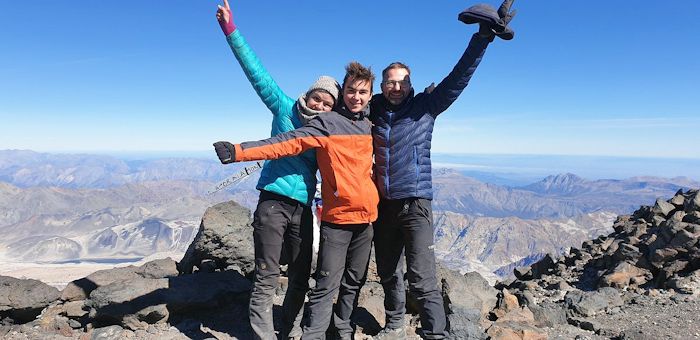
While remote, the Descabazado Grande volcanic field is relatively easy to access, being popular with hikers and climbers. Visitors typically fly into Santiago, 255 km N and take a 3–4-hour long bus ride into Talca, stay the night, and set out for the hike. A 2-hour bus ride to the mountains and the national park is the first leg. From the national park, the round trip to and from the top of the volcano is a relatively easy 5-day trip that can be done in 3 days in a pinch. The best time to climb is Oct – May, local summer.
Region
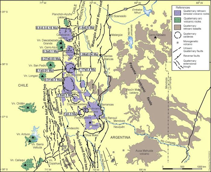
In this portion of the Andean Transitional Southern Volcanic Zone (TSVZ), the closest volcanic complex to the north is Planchon – Peteros, 42 km NE, while the closest to the south is Tartara San Pedro Pellado, 45 km. The closest neighboring caldera system is Laguna del Maule, 60 km SSE. As this is a remote and previously glaciated region, massive volcanic eruptions have not been well investigated until recent decades. There are more of them than expected leading some researchers to conclude that this portion of the Andes may have as significant a history of massive volcanic eruptions, ignimbrites, and caldera formation as the Altiplano region of the central Andes.
There are four main parts of the region, starting with the Calabozos caldera. Following its formation, activity shifted S and W of the center of the caldera, with the Descabezado Chico complex on the western rim of the caldera, and the Cerro del Medio complex on the southern rim of the complex.
Activity at the Cerro Azul – Quizapo – Descabezado Grande complex is more recent, starting some 350 ka, It is located another 15 km W from the caldera rim. This appears to be an independent system with its own magma source. There is some evidence that the volcanic centers in the region are interconnected. If so, it is likely as a result of regional faulting along the volcanic arc.
Calabozos Caldera
The largest volcanic feature in the region is the 14 x 26 km Calabozos caldera. The caldera was formed during multiple ignimbrite eruptions 0.8, 0.3 and 0.15 Ma. Each of these produced rhyodacitic to dacitic ashflow sheets 200 – 500 km3 apiece, the Loma Seca Tuff that extend some unknown distance into Argentina to the east. There are several hot spring clusters along the margin of the central resurgent uplift within the caldera. The region is ruggedly glaciated mountains, entirely roadless and uninhabited.
Present day andesitic volcanism began around 4 Ma. This built an extensive andesitic plateau of stacks of andesitic lavas. Stacks to the N of the caldera have been dated 2 Ma. These predate glaciation. The most recent andesitic lava dates 0.35 Ma.
The caldera floor is at 2,600 m. Central and eastern uplift are 3,000 m. Drainage is roughly radial from the caldera. The east wall is the continental divide. Glacial gorges have 500 – 1,000 m of local relief and have carved glacial gorges into the caldera, the rim, and ignimbrites deposited during the eruptions that formed it.

The present caldera is a composite trap-door collapse feature caused by the two most recent caldera-forming eruptions. The hinge zone is largely covered by more recent lavas and cones. Broad step-faulted regions mark the eastern and southern margins of the caldera.
After caldera collapse, resurgence domed the northern half of the caldera. Like the collapse, resurgence was also asymmetric, with maximum uplift on the eastern side of the dome and a graben on the western, hinged side.
The Loma Seca Tuff are three densely welded, plateau covering sheets that once filled deep glacial gorges. Within the northern part of the caldera, Unit V is at least 500 m thick. Its base has not yet been exposed. It is poorly welded and overlain by around 100 m of densely welded Unit S on top of the resurgent dome. At depth, Unit V is densely welded.

The Loma Seca Tuff sheets were erupted 0.8, 0.3 and 0.15 Ma. There are no known airfall deposits associated with the sheets. Some of the flow lobes were partially confined by local geography and in turn cut by subsequent glacial action. The three sheets from oldest to most recent are designated L, V and S. They can be found both inside and outside the caldera. Intracaldera tuff sheets tend not to be strongly welded, while those outside the caldera are. All three sheets appear to have erupted from the same system.
Outcrops of the L sheet measuring 100 m thick have been found.
The V sheet is the thickest, initially estimated at 250 – 300 km3. Tongues likely extended 50 km W to the Andean foothills. The thickest extracaldera outcrops are 350 – 400 m. Emplacement took place within hours. The intracaldera unit V is greater than 500 m with no bottom found as yet. The intracaldera V sheet appears to have been emplaced during the waning part of the eruption. Following the eruption, hydrothermal activity in the caldera altered parts of the tuff deposit.

The final caldera forming eruption took place after a 150 ka hiatus, a glacial episode, and eruption of a few andesitic lavas. This erupted unit S, with an early estimated volume of 150 – 250 km3. The maximum thickness of this densely welded tuff is around 300 m. There is a thin unwelded base layer. Welding peters out as the deposit thins to less than 50 m. Welded exposures have six or more alternating light and dark grey bands. This unit is overlain within 3 km of the caldera by remnants of 2 – 3 sheets 5 – 25 m thick emplaced during the waning stages of the eruption.
Following the second caldera-forming eruption, a large volume of eroded sand and gravel accumulated in the depression. These were interlayered with dacitic and andesitic lavas between units V and S. Following the unit S eruption, the tuff was covered by several lava flows, some of which banked against post-caldera uplift. Post-eruption erosion continued and covered unit S with interlayered lavas and erosive debris.

The composite trap door caldera is in two parts. The southern half is a broad basin floored by Unit S, erosion debris and younger lavas. The northern half is a high plateau created by structural uplift capped by Units V and S. Subsidence during the Unit L and V eruption took place in the larger caldera. Subsidence due to the Unit S eruption took place mostly in the southern half of the caldera. The SW wall of the caldera is entirely concealed by younger lavas, erosive material, and several post-caldera eruptive centers. Its location is inferred by the location of the younger centers and a major hot spring cluster. The west side of the caldera is thought to be a warped hinge zone.
Resurgence followed the Unit S eruption. The uplift dome is not symmetrical, with greatest uplift on the E side. This was also heavily glaciated. Resurgence quickly followed the eruption, no later than 50,000 years, possibly much less.
There are several clusters of hot springs along the fault zone bordering the resurgent dome uplift. Another large cluster is located along the concealed SW margin of the caldera. The hydrothermal system has probably been active for at least 300 ka. Similar hot spring systems are attractive targets for geothermal exploration. These systems will also precipitate out metals of interest in mining.
There are two groups of hot springs. The Colorado hot springs are located along a north-trending arc, skirting the base of the resurgent dome. The Puesto Calabozos group lies at the head of Cajon los Calabozos near the hinged margin of the caldera. Solfatatas are only found in the northern, most deeply eroded portion of the area at Llolli and Pellejo. It appears that hydrothermal activity started immediately after the eruption and has continued to the present.

Cerro del Medio
Post caldera activity was common and voluminous. These took place within the caldera and to the west. The 20 – 25 km3 dacitic to andesitic Cerro del Medio complex constructed at the southern end of the caldera includes several overlapping and nested craters. This system produced 6 km3 of sheeted dacites, andesitic cinders and one lava dome. It tops out at 3,500 m, 900 m higher than the caldera floor.

Descabezado Chico
A second cluster of cinder and dacitic cones was built west of the caldera, marking the western rim of the caldera. This cluster includes the four vents of Descabezado Chico, which has been active into post-glacial times. It erupted a late Holocene Escorias dacite lava flow, with a volume of 2.5 km3 traveling 30 km south. Descabezado Chico is currently dormant
A third, smaller center near the NW rim of the caldera also produced a thick layer of dacite products in Holocene times. There is also a layer of rhyodacite pumice on the plateau east of Cerro Negro. Its source is currently unknown.
Descabezado Grande
It appears that the Cerro Azul and Descabezado Grande system 15 – 20 km SW of the caldera may date back 0.35 Ma. They have been active at the same time as the caldera system. Volume of Cerro Azul is 40 km3, while Descabezado Grande is 70 km3 of andesites, dacities and pyroclastics. The rhyodacitic Mondaca lava flow fills a valley just N of Descabezado Grande. Historic accounts suggest it was erupted around 1760. Small volume, andesitic cinder cones, stratocones, and maars are common throughout the area. Most of them are west of the new Quizapu crater.
Volcano Quizapu, a flank vent of Cerro Azul last erupted in 1932, producing a 15 – 20 km3 Plinian tephra. Dexcabezado Grande erupted shortly after the 1932 eruption in June 1932 with a minor scoria eruption from its NE flank. A 600 m wide crater appeared on the northern flank of Descabezado Grande 2 – 3 months after the 1932 Plininan eruption of Quizapu. This vent was along the axis linking Cerro Azul, Quizapu and Descabezado Grande. No juvenile material was erupted and plumes several kilometers high were visible for months.

The three systems appear to share the same magma chamber, with magma reaching the surface via local faults. They were built on a shield of more than 100 lava flows, the Casitas Shield. There were at least 12 eruptive episodes. Top flows on the shield date 0.34 Ma. While lavas varied during the eruptive episodes, the two most recent episodes are the most evolved lavas, similar to lavas recently erupted from Cerro Azul. This is similar to lavas erupted from neighboring Tatara – San Pedro to the south.
There are two clusters of pyroclastic cones and maars located at the SW rim of the Descabezado Grande volcanic field, some 11 km SW of Quizapu crater. The Los Hornitos cones (LHC) are a pir of pyroclastic cones with pyroclastic fall deposits, scoria cones and associated lava flows. They are LHC-East and LHC-West, with the east cone being youngest. These erupted primitive magmas with tephras falling as far as 1.5 km from the vents. The tephras are layered lapilli and ash.
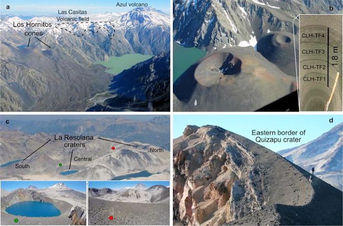
Some 8 km SW from Los Hornitos is a cluster of three vents that look like maars. These are the La Resolana craters (LRC). These mainly erupted tephras, with some lava from the northernmost crater. Once again, these erupted primitive magmas. Both groups are dated less than 25 Ka.
These vents appear to be located along a major tectonic boundary, the eastern border of the Abanico extensional basin which over time has faulted and folded,
There are a total of 41 mafic monogenetic vents identified in the region dating as far as 2.0 Ma. 30 of these are on the northern and western flank of Laguna del Maule. Many of these are undated. Locations appear to be controlled by regional faulting that has allowed primitive magmas to rise to the surface.
Volcan Quizapu
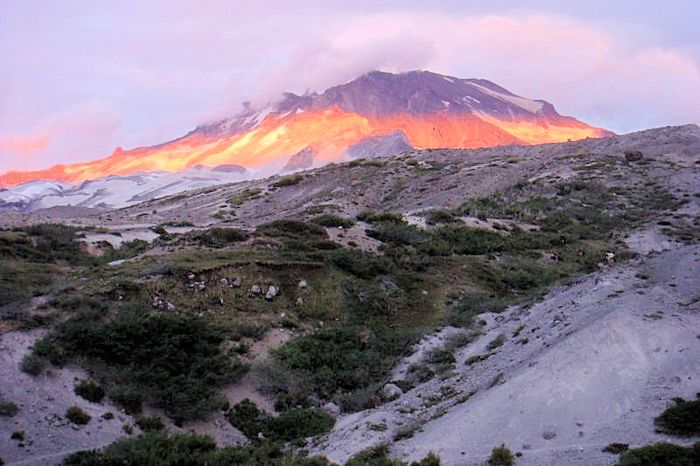
Quizapu first identified itself as an active volcanic vent in 1846 with a lava flow that started without any precursory felt earthquakes. It was the site of a 1932 VEI 5 Plinian eruption that put ash as far away as Uruguay and Buenos Aires. This was one of the strongest eruptions in the 20th Century.
It is a small volcanic cone on the northern flank of Cerro Azul on the ridge connecting Cerro Azul with Descabezado Grande. It is topped with a 700 m wide crater. The entire eruptive history of this vent took place 1846 – 1932 with major eruptions bookending the activity. Minor andesitic activity took place 1907 – 1931. The two VEI 5 eruptions from Quizapu are some of the largest historic eruptions from volcanoes in the Andean cordillera. There are five peripheral cinder cones. These contrast with the largely dacite larger stratovolcanoes.
Initial activity was during the winter of 1846 – 1847, where the volcano produced 4 – 5 km3 of dacite lavas that covered 50 km2 generally E and W of the vent. Products from this eruption showed extensive physical mixing of magma beneath the volcano. The explosive 1932 Plinian eruption produced a similar volume, dispersing ash across large parts of South America. This eruption showed little mixing between magmas. Scoria from the 1932 eruption ranges 2 – 6 m thick.
The underlying magma is thought to be stored in two chambers, with a deeper andesitic mush and a shallow dacite mush 3.5 – 4.5 km below the surface. The dacite mush is extracted from the deeper andesite storage from time to time. The 9 – 10 km3 dense rock equivalent erupted in 1846 – 1847 and the 1932 Plinian eruption are viewed as the system being tapped twice rather than being recharged between eruptions. Estimated chamber size is at least 50 km3. Dacites erupted in both eruptions are chemically similar.

Activity in a shallow reservoir is consistent with the opening of a phreatic crater on nearby Descabedado Grande volcano. This also means that the three systems may share the same magma chamber. There is some evidence that silicic lava flows and domes may initially erupt along fissures rather than from central vents. The location of Quizapu seems to support this trend. The initial eruptive vent in 1846 was a 1 km long fissure trending NNE. Flow field geometry supports multiple extrusion locations rather than a single point source. A linear fissure also allows the magma to degas in a more orderly manner, allowing it to erupt effusively. Orientation of the fissure is parallel with that of the greater volcanic arc. The fissure was filled with cooled magma toward the end of the 1846 – 1847 eruption. 1932 magma was discharged through a point source in an explosive eruption.
Tectonics
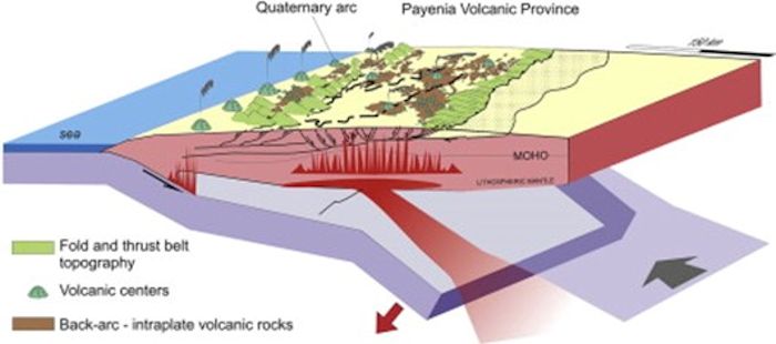
The volcanic arc in this portion of the Andes are 260 km E of the Chile Trench and 90 km above a plate dipping 20° beneath the continent. Convergence here is 9 – 11 cm/yr. Crust beneath the Andes here thins from 45 – 30 km. The thinning corresponds with a change from intermediate to basaltic volcanism east of the Andes. Volcanoes in this part of the Andes are on a basement 1,500 – 2,500 m above sea level on a crust about 40 km thick.
Volcanism in the region has been driven by changes in the subduction angle of the Nazca Plate beneath the South American Plate. Oldest volcanism shows chemistry of a mantle wedge above a typical subducting slab. This changed 15 – 10 Ma when the erupted magmas shifted to a basaltic, andesitic, dacitic mix. This is thought to be related to a decrease in subduction angle to a more typical flat plate subduction. That didn’t last long, as the slab angle returned to its original and current angle 8 – 3.5 Ma.

Volcanic activity related to these changes created three lines of volcanic systems. The farthest east is a massive basaltic volcanic province called the Payenia volcanic field to the east of the Andean forelands. There are two additional lines of active volcanic systems today along the cordilleran spine. The central group is a line of rhyolitic calderas dating 2.5 – 0.15 Ma. To the immediate west, there is a line of quaternary volcanic centers (stratovolcanoes).
When the subduction angle steepened, a massive injection of hot mantle fluids led to basalt flooding in the forearc, covering over 40,000 km2 from more than 800 vents. This basalt province is unique in the eastern Andean foothills. The thin continental crust over this portion of the subduction appears to be the difference between the widespread caldera and ignimbrite flareup of the Altiplano (thicker crust) and the basalt flooding of Payenia (thinner crust).

One of the similarities between the TSVZ and the Altiplano (both volcanic provinces associated with flat plate subduction) is the presence of large ash-flow eruptions in the region. Although the most recent of these in the TSVZ are the calderas and ignimbrites sheets deposited over the last few million years, it appears these sorts of eruptions have taken place much longer than initially expected. The largely pyroclastic Campanario Formation dates 15 – 6 Ma, S of Cajon Grande.
There is a striking difference between the extensive plateaus of welded ignimbrites in the Central Andes and the remaining welded tuff scraps in the TSVZ. This reflects the difference in erosion rates rather than a difference in volcanic activity. The central Andes region is arid while the TSVZ has extensive glacial erosion.
The long record of massive silicic pyroclastic activity, the existence of multiple recent calderas in the 33° S – 36° S present a threat to multiple major cities near the mouths of Andean canyons to the west of the Cordillera. On the other hand, geothermal potential from long-lived silicic centers located 40 – 60 km from major population centers is an opportunity.
Conclusions
With the relatively recent VEI 5 eruptions from Quizapu, the Descabezado Grande volcanic field has demonstrated that it continues to be an active and potentially dangerous volcanic system. The active hydrothermal system in the neighboring Calabozos caldera along with post-caldera volcanic activity demonstrate this system continues to be active. Finally, we have the 41+ monogenetic cones in the region that have been recently active. This region is volcanically active, capable of massive eruptions, which have been going on for nearly a million years.

Additional information
Smithsonian GVP – Descabezado Grande
Summit Post – Descabezado Grande
Discover the Andes – Volcanic field Descabezado Grande – Cerro Azul
Earthchem Decade – Details for Descabezado Grande
Mountain Forecast.com – Descabezado Grande – Climbing, hiking & Mountaineering information
Volcan Quizapu, Chilean Andes, Hildreth & Drake, 1992
Volcan Quizapu, 1932: Una de las mayores erupciones del siglo ZZ, Volcanologia Chile, Apr 2018
Experimental constraints on dacite magma storage beneath Volcan Quizapu, Chile, First, et al, May 2021
The Loma Seca Tuff and the Calabozos caldera: a major ash-flow and caldera complex in the southern Andes of central Chile, Hildreth, et al, Jan 1984
The hydrothermal system of the Calabozos caldera, central Chilean Andes, Grunder, et al, Jul 1987
Walking in the shadow of a great volcano, K Krajick, PhysOrg, May 2016


Wakeup call this morning in ANC. A M 4.7 struck around 5 minutes ago. Around 20 km N of the house, 24 km deep. These are preliminary numbers that will change over the next day or two. It was far enough away that there was a few second lag between the arrival of P/S waves and the surface wave. Pretty good thump that shook the house. We will hope it was the main event rather than a warmup. Cheers –
LikeLike
Pingback: Volcan Maipo, Chile – Argentina Border |
Pingback: Volcan Maipo, Chile – Argentina Border | | Travel Benguela
Pingback: Caldera del Atuel and the Diamante Caldera, Argentina |
Pingback: Caldera del Atuel and the Diamante Caldera, Argentina | | Travel Benguela