

The Barrier is a volcanic complex that sits at the southern end of Lake Turkana in the Kenya Rift. Its four shield volcanoes constructed over the last 1.4 Ma straddle the trough floor, blocking drainage from Lake Turkana to the north.
Volcanic activity here progressed from flood basalts to trachyte shields, and back to basalts. Water levels have fluctuated over 100 m, and there is a lot of interaction between erupted magmas and water forming pillow lavas, hyaloclastites, tuff rings, and tuff cones.
The area surrounding The Barrier is considered desert, with a hot and dry climate. Water in this part of Africa is at a premium. There are generally less than 200,000 people living within 100 km of The Barrier and the volcanoes in Lake Turkana to the N. As we proceed S along the rift valley, climate gets wetter and the population increases, with nearly 3 million within 100 km of Ol Kokwe Island, 200 km S of The Barrier. Most of the population around the volcanoes are tribal, with the local economics generally connected to agriculture.

Lake Turkana (Lake Rudolf, Jade Sea) dominates the northern part of the Kenya Rift, about half the length of the region we will be looking at in this post. It is 290 km long by 32 km wide. Maximum depth is 109 m. Average depth is 30 m. Its current surface level is 360 m above sea level, though during times of wetter climate, it has been as much as 100 m higher, most recently 9.5 and 3.5 ka, which impacts volcanism in and near it. It is the fourth largest salt lake in the world today.
The lake has been used for drinking water, though the water had high fluoride levels and is generally saline, making it unusable for irrigation. Despite this, the lake has a good population of fish, crocodiles, scorpions and vipers. The fish population is threatened by overfishing and falling water levels.

The lake has been around for a long time, as hominid fossils are abundant in the area around the lake. Multiple species of hominids have been living around the lake for millions of years.
The lake is fed by the Omo River. There is a hydropower dam under construction in Ethiopia which will reduce inflow into the lake. This project is highly controversial not only for its negative impact on water levels in the lake but the risk of major earthquakes in the region.

The region has been extensively surveyed for geothermal potential. As of this writing, only Olkaria has been developed for electrical generation. Its 130 MW output provides over 30% of energy in Kenya. There is a 2.5 MW pilot plant planned at at Eburru. Both are located in the southern part of the Kenya Rift, N of the Tanzania border between Menengai Crater and Suswa, some 360 km S of The Barrier.
Volcanoes in this part of Kenya are not monitored on a national basis. Any future eruption will likely be first identified via satellite observations.

Region
There are at least six volcanic centers in this portion of the Kenya Rift within 200 km to the S of The Barrier. There are three volcanic islands and a small basalt field within 200 km N in and on the shoreline of neighboring Lake Turkana. We described a number of axial shields in the Kenya Rift further south in previous posts. These include Suswa, Longonot, and a pair of posts on Menengai. There are several additional volcanoes to the E of the study area that show up in Volcano Discovery’s Kenya Volcanoes page but fall outside the scope of this post.
With the exception of Ol Kokwe Island, volcanic activity S of Lake Turkana including The Barrier generally built trachyte shields. Subsequent activity erupted trachyte pyroclastics followed by basalt lavas, scorias. Some of these interacted with water forming tuff rings, tuff cones, pillow lavas and hyaloclastites. Most local faulting is parallel with the rift axis, NNE – SSW.

Ol Kokwe Island
Ol Kokwe Island is located 199 km S of The Barrier. It is a small volcanic complex 4 km2 in the center of Lake Baringo. The main island is a group of coalesced scoria cones on top of a trachytic shield. There are a number of N – S trending faults cutting the complex, with W-facing scarps. Smaller islands to the N and S are faulted lava flows. Parmalok Island to the SW is a breached trachytic tuff cone the produced a small lava flow. The most recent eruption is estimated within the last thousand years. The island has an active hydrothermal system with hot springs, boiling mud and fumaroles. These are located along faults on the NE peninsula of the islands. Tourists visit the hydrothermal features on the island.

Korosi
Korosi is a shield volcano at the N end of Lake Baringo, some 18 NNE of Ol Kokwe Islands, 180 km SSW of The Barrier. It is the smallest volcanic center along this portion of the rift, covering some 260 km2. It is a shield rising up to 500 m above the trough floor. The shield is heavily eroded and broken by local faulting. There was no central crater. More recent eruptions built trachyte domes, produced trachyte lava flows, scoria cones, and fissure fed lava flows on the N flank. Major volcanism here took place 400 – 100 ka, erupting large volumes of fluid basaltic lava flows and scoria cones along a NNE trending fault across the shield. Most recent eruptions were a few hundred to a thousand years ago, around the same time as neighboring Ol Kokwe. There is an active hydrothermal system with fumaroles and hot steaming ground around the summit cones and NW flanks. The hydrothermal system covers at least 30 km2.

Paka
Neighboring Paka is located 18 km NNE of Korosi, some 163 km SSW of The Barrier. It covers 280 km2, rising around 700 m from the trough floor. The volcano is topped with a small 1.5 km diameter caldera. Most of the volcano is covered by young eroded pyroclastic deposits. The E and NE flanks are faulted by NNE striking faults creating a series of stepped and tilted escarpments separating the volcano from the E margin of the rift.
Large volume trachyte pyroclastics were erupted some 11 ka. These eruptions created a ridge of pyroclastic cones across the summit region. The summit caldera and associated craters may have formed during this eruption sequence. There is a second 1.0 x 0.5 km crater SE of the caldera. It has a scoria cone in it. The summit crater is breached to the N, funneling post-caldera lavas to the N. The three youngest post-caldera pyroclastic cones on the NE flank may only be a few hundred years old. Viscous trachyte lava flows were erupted from vents on the lower flanks. Young fissure-fed basalts were erupted to the S between Paka and neighboring Korosi. Surface hydrothermal activity is widespread on Paka within the summit caldera and on the N flank.

Silali
Silali is the largest volcano in the northern segment of the Kenya Rift. It is a low-angle shield rising 760 m above the floor. The volcano covers 850 km2, completely straddling the width of the rift, and is located 27 km N of Paka, 135 km SSW from The Barrier measured from center of calderas. The volcano is topped with a large caldera 7.5 x 5 km in diameter. The caldera rim is a 300 m cliff. There are several NNE trending fracture zones across the central and E part of the shield. These fractures opened fissures, created scarps and narrow graben structures. Many lava flows are well preserved, looking most recent on the E flanks. There are a number of young trachyte domes aligned along NNE trending fissures.

Caldera formation is thought to be 63 ka via an incremental collapse related to eruption of basaltic and trachytic lava flows. There are a series of summit benches formed by eruptions from circumferential fissures, similar to what we see in the Galapagos. There is a broad rift zone 10 km wide, 30 km long with numerous pyroclastic zones. Lava domes on the E flank were built around 11 ka, with this activity stopping 7 ka. There are numerous young parasitic cones on the caldera floor and on the N and NE flanks. The youngest lava flows may be as young as a few hundred years. Hydrothermal activity is located within the caldera and on the upper E flanks.

Emuruangogolak
Emuruangogolak is the neighboring shield located 39 NNE of Silali, 97 km SSW of The Barrier. It is located in the narrowest part of the inner trough, almost completely straddling it. It rises 1,000 m above the floor of the rift. The complex covers 525 km2 and is topped by a 5.0 x 3.5 km caldera. E and W flanks are a trachyte shield broken by NNE trending fault scarps and grabens. N and S flanks are covered by young trachyte and basalt lava fields with associated pyroclastic cones. These lava flows are contained in the rift trough and are readily visible in satellite images of the volcano.
There is a NNE trending chain of lake-filled maars along the floor of the rift from the lower flanks of the volcano. Parasitic cones erupted along rift parallel faults, cutting the volcano. The most recent lava flows date from the beginning of the 20th Century. The system has an active hydrothermal system with fumaroles and hot steaming ground located along NNE trending fissures within the caldera and along the lower NW flanks.
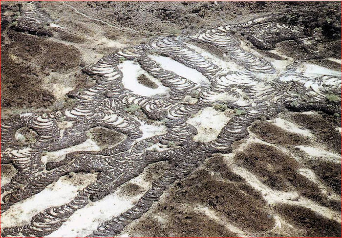
The Suguta Valley is the northern part of the inner trough between Emuruangogolak and The Barrier. It was flooded at various times over the last 11 ka creating Lake Suguta. Water terraces are visible on the trough walls, Namarunu, southern flanks of The Barrier and the northern flanks of Emuruangogolak. Much of the youngest volcanism on these three volcanic centers took place in the lake or on its shores, erupting pillow lavas, hyaloclastites, creating phreatomagmatic features such as tuff cones, tuff rings and maars.

Namarunu
Namarunu is the closest volcanic system S of The Barrier, located 54 km NNE of Emuruangogolak, 41 km SSW of The Barrier. It is a hilly volcanic complex on the W margin of the inner trough. The heavily eroded shield rises some 540 m above the floor of the trough. The volcano is old enough that the majority of the shield has been down faulted along with the floor of the trough over its lifetime. Recent volcanic activity along the axis of the inner trough has erupted extensive basaltic lavas, scoria and tuff cones, and tuff rings on the remains of the shield.
Many recent volcanic features were erupted under water, creating pillow lavas, tuff rings and tuff cones. Not all scoria cones erupted under water. The most recent eruptions took place after the lake dried up 3 ka. The most recent eruption appears to be from a breached scoria cone at the summit, which produced fluid basalt lavas. Hot springs are located on some of the younger volcanic cones on the rift valley floor and from the base on the E side of the rift.

South Island
South Island (Hohnel Island) is the southernmost of three volcanic islands in Lake Turkana. It is constructed of numerous tuff cones. Early activity took place under water during a period of high-water levels in the lake 10 ka. Additional underwater activity took place 3.2 ka during the most recent high-water level. Fresh lave flows erupted from a N – S fissure extending the 11 km length of the island. Basaltic lava flows are similar to recent lava flows from The Barrier. An eruption from a scoria cone was witnessed in 1888.
The island is around 40 km2, midway between the two shores of the lake. It rises 320 m above water level and 114 m from the bottom of the lake. The island is part of a larger horst block extending another 10 km N under lake sediment.

It has a N – S axial ridge of coalesced scoria cones along a fissure zone. There are young basalt flows to the E of the ridge. The western part of the island is constructed of older pyroclastics from deeply eroded tuff cones and rings.
Earliest activity was underwater with pillow lavas and hyaloclastites. This progressed to tuff cones and rings. The largest of these is on the NW part of the island, 250 m high with a crater 100 m deep. There is a small spatter cone on the rim. Tuffs are interlayered with lake sediments. Former high lake shoreline is 50 above the current surface. The island as a whole is recent, perhaps as old as 11 ka. There is no geothermal activity on the island.

Porr
Porr is a small area of basalt lava flows coming from what appear to be at least two sources on the northern shore of Lake Turkana. Smithsonian GVP notes that the flows are not associated with any prominent volcanic center. There is a small volcanic cone that may be younger than 11 ka. Porr is located 32 km N of South Island, 71 km N of The Barrier.

Central Island
Central (Crocodile) Island rises 170 m above the current surface of the lake. The greater volcanic structure is some 5 km in diameter rising from the lake bottom depth of 45 m. The island is constructed by multiple coalesced tuff cones and tuff rings. The island is young, but so far undated, and like South Island, initial eruptions were associated with lake water. More recent eruptions produced lapillis, ashfalls, breccias, and minor lava flows. Water levels in the crater lakes change with water levels in the lake. There are shoreline benches 10 – 17 m above current lake level at several locations around the island.

The island is composed of more than a dozen craters and cones. Three of these are filled with small lakes. The two largest lakes fill craters 1 km in diameter and 80 m deep. The island is located in the center of Lake Turkana, some 115 NW of Southern Island, 154 km NW of The Barrier. There is an E – W chain of small explosion craters on the E side of the 3 km wide island. Three small islands to the SE are partly submerged crater rims. Other cones and lava plugs are below water level near the island. The youngest tuffs and lavas may be younger than 11 ka.
There is a vigorous hydrothermal system on the island with fumaroles and solfataras. These are located on the NE – SE rim of the central crater. There are numerous hot springs within the main crater lake. Sulfur sprays from the fumaroles were observed in the 1930s. An intense emission of liquid sulfur and steam was observed in 1974.

North Island
North Island is the northernmost and smallest of three volcanic islands in the lake. Like the other two, it is constructed from deposits of multiple tuff cones and tuff rings. It is located 63 km N from Central Island, 206 km N from The Barrier. It tops out some 140 m above current lake level. Water depth in this part of the lake is 80 m.
The center of the island is a young tuff ring some 1 km in diameter nested inside an older one. There are two fresh lava flows that reach the lake shore from the central tuff ring. They form deltas on the N and W side of the island. The northern delta is 900 m wide. These are younger than a shoreline bench some 10 ka. The youngest bench is 76 m above current lake water level some 3.2 ka. Trachyte lavas from the northern cone are younger than this bench.

The island is constructed from phreatomagmatic deposits from multiple tuff cones and rings in various stages of preservation. There are remnants of one or two old cones along the S shore. These are lapilli tuffs with thin basalt lavas. The young tuff ring is located in the center of the island.
The island has hydrothermal activity along a curved ridge on the S portion of the island, and on wave cut platforms and beaches on the SW shoreline. The activity is vigorous with numerous strong fumaroles and solfataras. There is widespread areas of altered clays with gypsum and sulphates.
Part 2
Part two will look at The Barrier, regional tectonics and conclusions.
Additional information
Status of geothermal exploration in Kenya and future plans for its development, SM Simiyu, Apr 2010
Late quaternary caldera volcanoes of the Kenya Rift Valley. Williams. Et al, Sept 1984
Sequence and geochronology of the Kenya rift volcanics, Baker, et al, Mar 1971
Tectonic evolution of the northern Kenyan Rift, Morley, et al, Jun 1992

