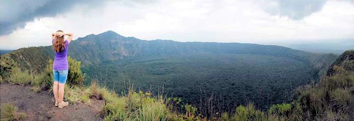
Mount Suswa from the rim of the oldest caldera. Image courtesy African Spice Safaris
Ran across this volcano courtesy of the Smithsonian Global Volcano program. It is located on the Kenya section of the East Africa Rift and has undergone an incremental caldera collapse giving it a multiple ringed caldera.
Mount Suswa is a double caldera volcano located inside a shield shaped cone. At its center, steep cliffs plunge more than 500 m into a ring-shaped moat. The inner crater has a circular moat that surrounds a lava plateau a few kilometers across. The caldera is covered with tangled shrubs with some parts sill smoldering due to active fumaroles. The Maasai consider this part sacred and no hunting or grazing is allowed.
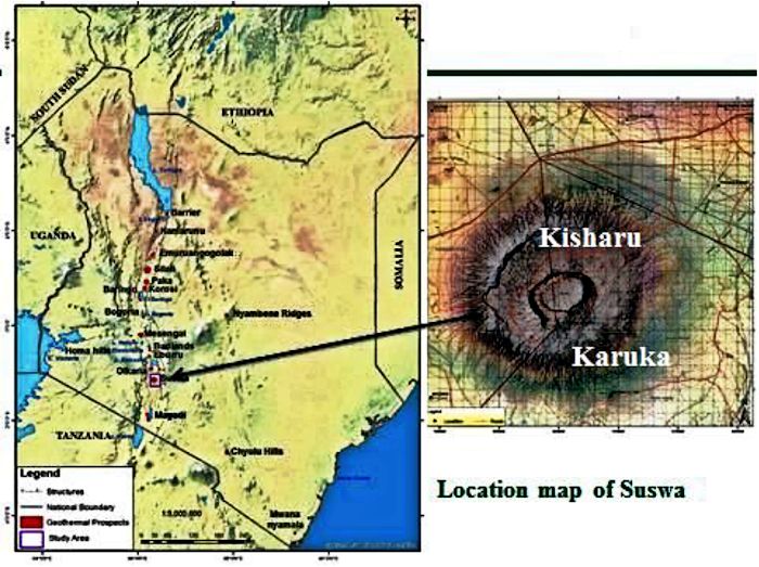
Location map of Suswa. Image courtesy Raymond Mwakirani, 2013
The volcano has 105,000 people living within 30 km and nearly 7 million within 100 km. Most of those are in neighboring Nairobi 50 km away to the south. Suswa is located between Narok and Nairobi in southern Kenya and is less than 400,000 years old.
Best access to climb Suswa is from the N and NE. The entire area can be hiked. There are many Maasai homesteads on the base of the mountain. Hikers are advised to introduce themselves to the head of the family when transiting their homestead.
It is possible to drive into the outer crater with a 4-wheel-drive vehicle. But there are enterprising local Maasai who have erected multiple barricades across the trail and collect fees for passage. It is possible to hire a guide and pay a single fee.
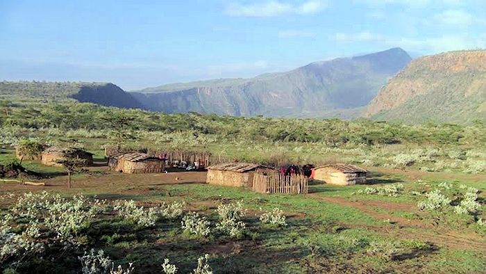
Village on the exterior flank of Mount Suswa. Image courtesy Africa Geographic.com, 2016
The inner crater is populated by a variety of snakes, which means there is also a thriving population of rodents, smaller mammals and birds. Wildlife found on or near Suswa include zebra, giraffe, mongoose, turtles, hyenas and leopards.
Climate is generally dry and hot. Rainfall over the region ranges from 35 – 70 cm / year. Vegetation is stunted thorn bushes, grasses, with stream beds lined with trees and thicker vegetation. Vegetation in the central island block and its surrounding graben is thicker than that on the flanks and greater rift valley below the volcano.
There are a large number of lava tubes on the eastern flanks of Suswa. Explored portions are up to several kilometers long and similar to lava tubes found in Hawaii. Entry points are generally roof collapse and the tunnels exist on several levels. Tunnel walls in places have lava stalactites. There are over 30 entrances to the caves, most of which are collapsed roofs. Over 10 km of tunnels have been mapped with large areas unexplored.
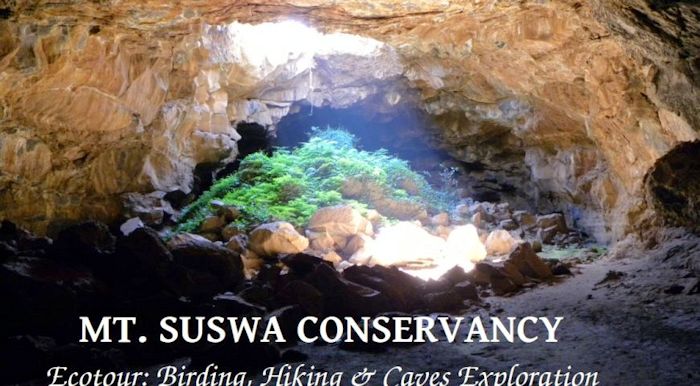
Suswa lava tube skylight from partway down the tube. Image courtesy Mt. Suswa Conservation Trust
One of the locations in the caves is Baboon’s Parliament. Baboons roost in the treetops to avoid night prowling big cats. In Suswa, they shelter at night in an underground lava tube known as the Baboon’s Parliament (note that a congregation of baboons is neither a congress nor a parliament; rather it is a troop despite political commentary to the otherwise). There are a series of ledges high up on the cave wall that the baboons use to last through the nights.
The troop’s arrival in the evening coincides with the departure of local bat colonies. The Suswa caves may host the world’s largest colony of giant mastiff bats. As last light fades, the bats exit, and the baboons enter. In the morning, the process reverses itself.
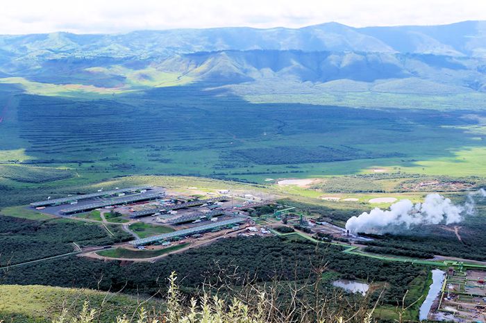
Olkaria geothermal energy plant. Image courtesy Earth Island Journal, 2017
The Kenyan Ministry of Environment and Natural Resources, Mines and Geological Department published Geology of the Suswa Area in 1991. It is a 47-page document detailing the volcano and surrounding area intended to lay the foundation for possible geothermal energy production and controlled development of Kenya’s mineral, groundwater and energy resources. The report is one of the better descriptions of the region I have found and survived translation into English pretty well.
The availability of high heat flow along the rift has allowed locals to exploit existing geothermal systems. Olkaira is sized at 173 MW and has been producing since 1981. Neighboring Eburru is sized at 20 MW. Detailed studies at Suswa and neighboring Longonot suggest power output from future geothermal installations may be over 400 MW. Total possible geothermal electrical generation out of the rift in Kenya alone should exceed 1,000 MW, larger than Alaska’s rail belt.

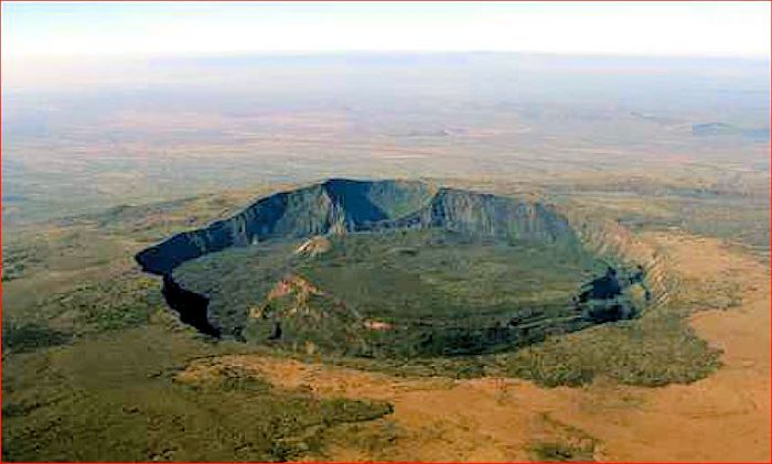
Landsat photo of Mount Suswa clearly depicting both caldera scarps. Image courtesy Smithsonian GVP
Volcano and Eruptions
Mount Suswa is one of the largest and perhaps the most complex of multiple central volcanoes in the eastern Rift Valley of Kenya. It rises from the rift floor around 1,500 m above sea level to 2,357 m at the top of Ol Doinyo Nyukie. The asymmetric cone covers 270 km2. Volcanic products from it cover as much as 1,035 km2.
The cone was built on a floor of trachyte flood lavas (Plateau Trachyte Series). It consists of sodalite-bearing phonolitic lava flows and pyroclastic rocks. The volcano hosts an 8 x 12 km caldera. It is the southernmost caldera on the Kenya rift (Kenya’s portion of the East Africa Rift). The volcano was originally a large lava shield. It erupted a significant volume of pumice and lava flows during the formation of the larger caldera (Caldera I). The post-caldera lava cone Ol Doinyo Onyoke (The Red Mountain or Ol Doinyo Nyukie) is constructed from phonolitic to trachytic lavas topping out at 2,356 m above sea level. It is located on the southern side of Caldera I.

Caldera II scarp with center island to the left. Image courtesy African Geographic, 2016
The most recent caldera (Caldera II) is a 5 km diameter ring graben at the center of the older caldera. Most recent eruptions from Suswa are from satellite vents that produced lava flows. The most recent lava flow of these may be only a century or so old. There are at least two magma chambers known to lie at depth below the Suswa cone, one of which is at 14 km. Lunar geologists have used Suswa as an example to describe some interesting crater patterns seen on the moon.
There are multiple N-S linear faults south of the volcano that cross the basement lavas. They die out and converge toward the center of the ancestral volcano. It is not always possible in the south to distinguish between the trachyte flood lavas of the basement and lava flows from the central vents of the early stage vents. Many of the early lava flows of Suswa were quite large, with the earliest flows being the most voluminous. Early flows from Suswa erupted during faulting in the rift. A few of these flowed over fault scarps and were changed by more recent fault movements. The block faulting to the south ended around the same time volcanic activity at Suswa began.
Caldera II and internal island. Note how isolated the central island is. Image courtesy Terra Conservation Films
Primitive shield lavas (earliest eruptive Unit 1) are primitive phonolite basalts. They show columnar jointing in places. It is difficult to distinguish between early Suswa phonolites and the basement trachytes. There are several flood lavas to the south of Suswa. The earliest lavas are the least evolved.
The caldera formation took place after a period of quiet and produced large quantities of pumice, pyroclastics and lavas (Unit 2). The scarp around the caldera is generally 110 – 160 m above the floor. The caldera floor is covered entirely with post-collapse lavas. VOGRIPA lists the Caldera I eruption as a VEI 5.9, ejecting a bulk volume of 7.1 km3. It is dated at 240,000 years ago.
After a period of relative quiet, regional extension provided pathways for siting, recharge, and drainage of magma chambers leading to the initial (Caldera I) collapse. This collapse is described as a Valles-type collapse with magmatic overpressure, volatiles explosively driving the eruption, magma-water interaction, influx of denser and hotter magmas, and magma drainage at depth. The initial phase of the eruption produced trachybasalt ash, ignimbrites, pumice-lapilli ashfall tuffs, and carbonate-trachyte ignimbrites. Airfall tuffs erupted during the collapse are interbedded, suggesting a regional collapse event that proceeded incrementally. This collapse erupted trachyte flows from concentric ring fractures outside the caldera ring fault and produced trachyte pumice lapilli airfall tuffs from the western part of the caldera. The ring feeder lavas flowed mainly on the upper part of the outer flanks. In places, they dip into the caldera itself. Similar lavas erupted from N-S fissures on the northern flank. These were generally quite viscous lavas.

Newly formed rift swallows part of road near Suswa. This is still a geologically active region and rifting continues. Image courtesy The Watchers blog, 2018
Earliest caldera forming eruptions produced pyroclastics up to 2 m thick on the N, E and S flanks of Suswa. Deposition of these is thought to be via lahar action. Later deposits of pumice are much thicker, well bedded and sorted. Pyroclastic rocks on the western flank are up to 60 m thick. This layer has been sharply eroded. This layer thins on the northern and southern flanks and is not present on the eastern flank.
Magmas for both the Unit 1 and Unit 2 eruptions are thought to be quite similar, with the Unit 2 magmas being more evolved. Suggested storage for these magmas is calculated at some 14 km below the volcano. The process leading to the eruptions is driven by recharge of basaltic magmas, mixing, and reabsorption of crystalized magmas.
Post caldera eruptions took place mainly within the caldera. These lavas partly filled the caldera, overflowed the lowest part of the rim, and extended down the southern and eastern flanks as long, narrow (less viscous) flows. Some of these show pahoehoe surface features. Toward the end of these eruptions, the Ol Doinyo Nyukie collapse crater and inner ring graben formed within the caldera.
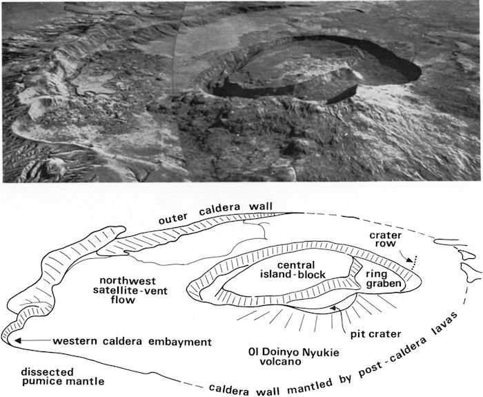
Image and annotated drawing of the Suswa caldera system and Ol Doinyo Nyukie truncated cone. Image courtesy UC Denver, 2013
The oldest of these post-caldera lavas (Unit 3) ponded against the NE caldera wall. Later lavas overflowed the eastern caldera wall and extended down the outer flanks to the Kedong basin. These lavas contain a network of lava tubes and collapse holes in the flows. Initial Ol Doinyo Nyukie lavas overly these earlier lavas in places and cover the sources of the early post-caldera lavas on its outer flanks.
The second major collapse of Suswa took place entirely within the older caldera and produced the interior ring graben (Caldera II). This collapse appears to have been a cold collapse due to subsidence as there are no lava flows or pyroclastic materials associated with its formation. The graben is a pair of concentric fault scarps bounding a subsidence zone that isolates an oval, flat topped, steep sided, island block measuring 3.7 x 2.4 km. The block is also tilted slightly to the NW. Most of the block surface lies below the scarp rim. The ring graben is 490 – 1,830 m wide and partly cuts the Ol Doinyo Nyukie cone and summit pit crater.

Schematic cross section of Suswa. Image courtesy UC Denver, 2013
The most recent eruptions (Unit 4) took place mainly from Ol Doinyo Nyukie creating a cone rising some 485 m above the caldera floor. There were several satellite eruptions that broke through the flank of the crater and main summit vent widened to form the current pit crater. The base of the cone in the NW wall of the ring graben sits on a pyroclastic layer up to 30 m thick. Ol Doinyo Nyukie is topped with a pit nearly 1.5 km in diameter that may be referred to as a third, Kilauean summit caldera. It was apparently created by low level eruptions and withdrawal of subsurface magma from the cone.
Satellite vents produced two prominent lava flows, several flow units, and a number of small lava cones. A third satellite vent flow is thought to be present on the island block inside the interior ring graben. The age of the interior ring graben collapse is uncertain as it does not cut any Ol Doinyo Nyukie lava flow. The most recent flows on Suswa are younger than the interior ring graben and are petrologically similar to the Ol Doinyo Nyukie lava flows. They may be only a century or two old. The summit crater of Ol Doinyo Nyukie enlarged to its current size sometime after the last two lava flows erupted.

Active hydrothermal activity on the caldera scarp in Suswa. Image courtesy Africa Geographic, 2016
There is extensive geothermal activity on Suswa. Hot spot location are visible as bald spots in the vegetation which favor the growth of a particular type of plant. Emissions are generally small columns of steam, though occasional small geyser blasts have been observed. Fumaroles are found on the exterior ring fracture in the caldera. The fumaroles in the northern part of the ring graben are well developed.
There are no known Holocene eruptions from Suswa. It underwent a single subsidence period 1997 – 2000 detected by InSAR as a subsidence of 2 – 5 cm 1997 – 2000. The conclusion is that this is episodic and consistent with a volatile rich cap to a crystal rich magma chamber beneath the volcano.
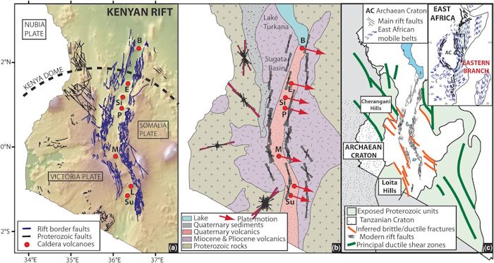
Location map of Kenya Rift portion of East Africa Rift. Suswa is depicted by the bottom red dot “Su.” Left hand image shows locaitn of rift border faults and major faults. Middle image is a summary geological map of Kenya with the relative motion of the Somali Plate depicted. Right hand image is the Kenyan Proterozoic units and principle structures. Image courtesy Robertson, et al
Tectonics
The Kenya Rift valley is part of the East African Rift that runs from the Afar triple junction in the north to Beira, Mozambique in the south. It is part of an ongoing continental rift of Africa. Thinning of crust is occurring and with it, eruption of lavas and associated volcanic activity. There is thought to be a major plume underlying the Afar and Ethiopia. Rifting within Kenya started some 30 Ma. Most volcanic activity is concentrated along the axis of the rift. The lithosphere – asthenosphere Moho boundary is relatively shallow and trending shallower over time.
There are seven major trachytic caldera volcanoes in the Kenya Rift Valley. The southern group includes Suswa, Longonot and Nenengai. All have large calderas approaching 100 km in diameter thought to have formed by Krakatau (or Valles)-style eruptions. These eruptions produced large ash flow and airfall tuffs in the 20 – 50 km3 range.

Simplified geologic map of Suswa. Reds and browns are various lava and pyroclastic flows. Greens to the south are various trachytes and basalts. The farther you go south, the more faulting is visible. Screen Capture from Geology of the Suswa Region, Kenya, 2013
The more northerly group including Barrier, Emuruangogolak, Silali and Paka formed their calderas with little pyroclastic activity with the collapse thought to been due to withdrawal of magma from depth beneath the cone.
There were three distinct periods of rift faulting. The first cut the basement rocks and created the western rift margin with a drop to the east. This fault was followed by eruption of Kirikiti basalts, which were in turn dropped when a more recent fault created the Kirikiti platform. This was followed by eruption of more trachytes on the floor of the new rift. The third movement was much more recent. Total throw of the faults is variable and they tend to die out quickly, and quickly replaced by others which continue the overall movement. Fault blocks are generally tilted in a southerly direction.

Entrance to Suswa lava tube cave. Image courtesy Travel Diaries Kenya
Volcanic activity associated with the East Africa Rift has been going on for at least 11 Ma. The region is covered with interbedded pyroclastics, basalts, welded tuffs and trachytes. Volcanic products of Suswa and its immediate neighboring volcanoes start showing up some 400,000 years ago. Extensive lava flows described as flood deposits are found in the Kedong Valley as recent as 100,000 years ago.

Caldera II island from Ol Doinyo Nyukie. Image courtesy Daily nation, 2019
Conclusions
While close to several millions of people Suswa is considered relatively safe. As with most recently active volcanoes, this may not last. It is currently quiescent with very likely a crystal mush in its underlying magma chamber. Problem is that the rift keeps on opening, creating pathways for additional hot, juvenile basalts to mix with the mush in the existing magma chambers. Given the hydrothermal activity in and around Suswa and observed subsidence a couple decades ago, I would not count this volcano out of the game just yet.
Additional Information
https://volcano.si.edu/volcano.cfm?vn=222110
https://academic.oup.com/gji/article/179/1/549/2011972
https://royalsocietypublishing.org/doi/abs/10.1098/rsta.1969.0061
https://link.springer.com/article/10.1007/BF02596937
https://jgs.lyellcollection.org/content/150/5/885
https://pubs.geoscienceworld.org/gsa/geology/article-abstract/37/11/979/29889
https://agupubs.onlinelibrary.wiley.com/doi/abs/10.1029/JB089iB10p08553
https://s3-eu-west-1.amazonaws.com/samsamwater1/maps/kenya/geology/Geology+of+the+suswa+area.pdf
http://theargeo.org/home/files/Kenya/Petrogenesis%20of%20the%20Suswa%20Volcano.pdf
https://orkustofnun.is/gogn/unu-gtp-40-ann/UNU-GTP-40-B-2-Geoffrey-Mibei.pdf
https://africageographic.com/blog/spectacular-mount-suswa-kenyas-rift-valley/
http://citeseerx.ist.psu.edu/viewdoc/download?doi=10.1.1.555.9326&rep=rep1&type=pdf
https://www.geosociety.org/maps/2014-DMCH016/DMCH016_S1e_Suswa.pdf


Pingback: Revisiting Menengai Crater, Kenya |
Pingback: The Dakataua Caldera and Crater Lake, PNG |