

Concepcion Volcano -http://www.sustainabletrip.org/blog/index.cfm/2013/5/24/Photo-of-the-Week-A-Rainbow-Volcano
Concepcion volcano is a 1,600 m tall stratovolcano that shares the Island of Ometepe with Maderas. The island sits in Lake Nicaragua, the largest lake in Nicaragua. It is both the tallest and most active volcano in the country, last erupting in 2014. The current series of eruptions are ongoing.
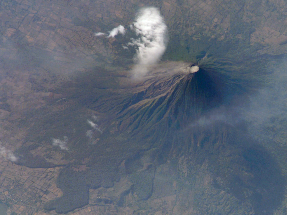
Concepcion from ISS 2007. http://visibleearth.nasa.gov/view.php?id=7722
Its base above water is around 14 km in diameter. The volcano erupts basalt to andesitic dacite lava, tephra and pyroclastic materials. It upper slope is barren and was mostly built between 1883 and 1977. The cone occupies and almost completely buries what may or may not be a small caldera from its first eruptive cycle. http://link.springer.com/article/10.1007%2Fs00445-002-0256-8#page-1
The volcano has been very active, erupting over 25 times since 1883. Most of the eruptions were VEI 1-2 in severity. Eruptions are mostly explosive in nature. There are active fumaroles on the crater.

Concepcion explosion -http://www.panoramio.com/user/1221098/tags/volcanic%20eruption
The Island of Ometepe is some 276 km2 in area, measuring 31 km by 5 – 10 km wide. The volcanoes occupy the ends of the island. There are nearly 30,000 people living on the island full time. Primary industry is livestock, agriculture and tourism. The island sits some 100 km SSE of Nicaragua’s capital of Managua and its 2.22 million people.

Map of Ometepe Island and its two volcanoes – http://www.hospedajesoma.com/en/ometepe.html
Nicaragua hosts some 19 volcanoes, six of which erupted over the last century. The volcanoes are part of the Central American Volcanic Arc or Belt.

Nicaragua Depression showing volcanoes – http://specialpapers.gsapubs.org/content/412/141.figures-only
Volcano
The volcano grew within what is called the Nicaraguan Depression, which is a graben that extends some 800 km through El Salvador, Nicaragua, Costa Rica and into the Caribbean Sea. It is home to almost all of Nicaragua’s volcanic activity.
The graben contains the two large lakes, Lake Managua and Lake Nicaragua. Concepcion grew through Lake Nicaragua and sits on the thick sediment below the lake. It is referred to as having “feet of clay” as its base is built on lake sediments, clays and other strata. As such, it is structurally weak and the entire edifice is spreading outward from its center due to the force of gravity. This spreading also influences the evolution and behavior of its relatively shallow magma chamber.
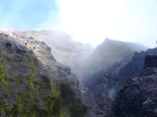
Concepcion crater – http://www.tripadvisor.com/LocationPhotoDirectLink-g304024-d309906-i48983212-Concepcion_Volcano-Isla_de_Ometepe_Rivas_Department.html
Eruption styles range from full Plinian to sub-Plinian and most recently Strombolian. There are lava, domes, pyroclastic flows and tephra observed from historic eruptions.
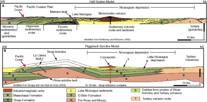
Geology underlying Concepcion – http://gsabulletin.gsapubs.org/content/121/11-12/1491/F6.expansion.html
Eruptions
Concepcion had two fairly large historic eruptions. The oldest was a VEI 5 some 19,000 years ago. That eruption produced some 5.2 km3 of material. It is referred to as the Upper Ometepe Tephra.
A more recent large eruption around 861 BC produced 0.1 km3 of material, about one tenth that Mount St. Helens did in 1980. That eruption is classified as a VEI 4. http://www.bgs.ac.uk/vogripa/searchVOGRIPA.cfc?method=detail&id=2502
Concepcion shortly after an explosion from Ometepe Island – http://anthonyjohncoletti.photoshelter.com/image/I0000uOwokVzT70s
Frequent eruptions since 1883 have all been in the VEI 1 – 2 range. They have grown the height of the cone and kept the upper half of the mountain barren of vegetation. They have also produced a lot of tephra deposited downwind. Prevailing winds are typically east to west.
Current activity has been explosive in nature, with over 2,400 explosions since the current round of activity started in 2014. Smithsonian GVP reports 117 explosions between 30 June – 7 July 2015.

Two weeks of explosions in 2010 – http://volcano.si.edu/volcano.cfm?vn=344120
The four known sequences of eruptions begin with a mostly basaltic series of eruptions. Over time as the magma cools and crystallizes, eruptions become increasingly explosive in nature until a new large injection of magma occurs and the cycle repeats. Early cycle eruptions are typically heavily basaltic and emit from the base of the volcano.
At the end of the first known cycle of eruptions, the VEI 5 eruption some 19,000 years took place. This may have left a small caldera which was refilled by later eruptions. The first eruptive phase started with low alumina basalt that evolved into dacitic magmas. The last three cycles have been fairly recent, over the last 2,500 years and are characterized starting with high alumina basalts and evolve to silicic andesites. Residence time of magma during the last three cycles appears to have decreased as magma has not had time to evolve from basaltic to dacite. Concepcion is thought to be near the end of its current eruptive cycle.

Concepcion in 2009. This is not an eruption. http://www.dpchallenge.com/image.php?IMAGE_ID=771251
The other interesting thing about Concepcion’s eruptions is the slumping action of the volcano on its clay base. This is thought by some scientists to have modified the shape of the shallow magma chamber, thus triggering eruptions and shaping the nature of those eruptions.
The cone itself is riddled with fault lines and scarps. It is also capable of producing significant lahars due to the loose tephra that is produced on a regular basis. These lahars are caused by rainfall rather than melting of ice and snow.

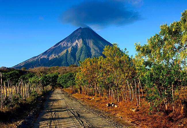
Concepcion with cap cloud. This is not an eruption either. https://www.pinterest.com/pin/206391595395165587/
To date, no cone collapse has been observed throughout its history which is somewhat odd considering its shape and height. The Borgia and Van Wyk paper suggests that due to the spreading of the edifice on soft underlying strata, forces that would make the cone collapse are relaxed and dissipated before they can come into play and tear the cone apart.

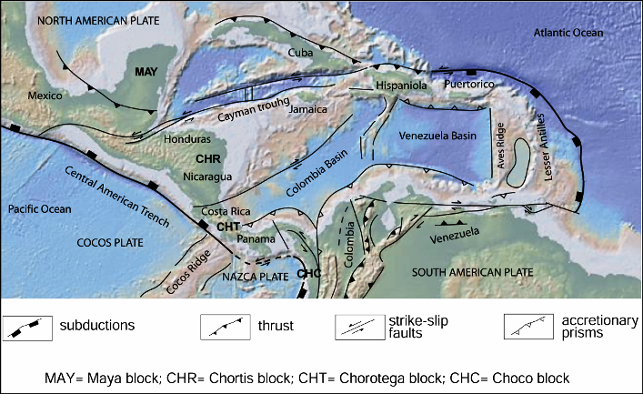
Central American Tectonics – http://specialpapers.gsapubs.org/content/428/1/F1.expansion.html
Tectonics
Tectonics of Central America is driven by the subduction of the Cocos Plate under the Caribbean Plate. There is a triple junction in southern Mexico with the North American Plate. There is another triple junction in the south with the South American Plate. Finally, Panama is referred in some locales as a microplate. The Middle America Trench sits offshore to the west. Over geologic time, the Caribbean plate pushed through the gap between North and South America.
Caribbean Plate tectonics – http://www.intechopen.com/books/new-frontiers-in-tectonic-research-general-problems-sedimentary-basins-and-island-arcs/the-caribbean-plate-evolution-trying-to-resolve-a-very-complicated-tectonic-puzzle
The Central American Volcanic Arc / Belt are primarily back arc subduction volcanoes. As with all other complex regions, there is a twist. In the case of Central America, the graben called the Nicaragua depression opened up shortly after a significant ignimbrite outbreak in the region of El Salvador through Nicaragua to Costa Rica. This outbreak took place in the late Miocene some 5 – 15 million years ago and produced significant andesitic and dacitic material.

Central American ignimbrite outbreak – http://specialpapers.gsapubs.org/content/402/175/F1.expansion.html
The area north of Concepcion has multiple calderas with fairly recent (in geologic terms) eruptive histories. One of the referenced papers believes the Chortis block which contains Nicaragua and is bound on the north by the Guayape Fault through Honduras is rotating counterclockwise, which in turn allowed the entry of magmas fueling the ignimbrite outbreak referenced earlier to the surface and opened up the depression containing the lakes, calderas and other volcanic structures.
The paper compared the opening of that depression with the opening of the depression that allowed the Toba magmas to reach the surface.

Concepcion explosion close up – http://www.panoramio.com/photo/6684742
Conclusions
Concepcion is a case of a volcano that was built on a soft foundation. This has allowed the volcano to operate through several eruptive cycles without the normal sorts of cone collapses, debris flows and caldera forming events we normally see from other stratovolcanoes. When the entire edifice is slowly spreading, the normal structural loads that would catastrophically tear apart a volcano are released incrementally over time.
This slow spreading has also helped drive what is going on in a very shallow magma chamber, only a couple kilometers below the volcano itself.
Would not surprise me if this volcano were to be moderately active for many years to come.

Concepcion from Ometepe Island in the evening – http://richyfeet.com/one-dark-night-in-ometepe/
Additional Information
http://www.geo.mtu.edu/~raman/papers2/CentralAmer/DeMets/demets_grl.pdf
http://link.springer.com/article/10.1007/BF02597631#page-1
http://geology.gsapubs.org/content/14/1/79.short
https://books.google.ca/books?hl=en&lr=&id=eJgcnw5p6qEC&oi=fnd&pg=PA21&dq=central+American+volcanic+belt&ots=gPizN5l_0P&sig=QG-Nr5kJ_b705n3Uzuscw8iB-cA#v=onepage&q=central%20American%20volcanic%20belt&f=false
http://www.sciencedirect.com/science/article/pii/S0009254199001011
http://gsabulletin.gsapubs.org/content/88/1/151.short
http://link.springer.com/article/10.1007/s00410-007-0251-3#page-1
http://www.sciencedirect.com/science/article/pii/0040195183901075
Click to access CarretalAGU.pdf
Click to access 0deec51af968c670c3000000.pdf
http://www.geo.mtu.edu/~raman/Seminar2011/Wednesday%28Mar16%29__files/Borgia%20and%20Van%20wyk.pdf


Update Piton de la Fournaise: OVPF reported that the tremor has stopped yesterday. With that the eruption has been declared over. http://www.ipgp.fr/fr/ovpf/actualites-ovpf
Image: REUTER
LikeLike
Update Gunung Sinabung: After very strong activity since last mid-week with, Sinabung has quietened down a bit. Previously, up to 6 PFs occured per day, the longest going up to 4.5 km down the valley. But there will be no end to it yet, as magma movement within the volcano is still recorded, supplying it with fresh material.
Gunung Gamalama: After two weeks of ash plumes, activity has declined to steam explosions without ash. Evacuated people start returning to their homes, airports in affected areas are opening again.
http://regional.kompas.com/read/2015/08/03/12211461/Frekuensi.Luncuran.Awan.Panas.Sinabung.Menurun.Kegempaan.Masih.Tinggi
LikeLike
Hi
some update on the situation in Nishinoshima. There seems to be more sulfur on the volcanic cone, but the eruption is still going on.
http://www1.kaiho.mlit.go.jp/GIJUTSUKOKUSAI/kaiikiDB/kaiyo18-2.htm
Here is the previous picture if the cone. The dates are shown on the pictures.
Courtesy of Japan Coast Guards.
LikeLike
Pingback: Gunung Semeru, East Java, Indonesia |