

Meakan crater, looking south. (© propeller2002 on Panoramio)
This is about a volcano of which I had not even heard before our reader Virtual sent us a great video of his travels in Japan (thank you, Virtual!). It was in the comments in June of this year but I re-post it here as an introduction to this article.
But that was not the reason I decided to research and write this post: About four weeks after Virtual’s video, on 12 July, a rapid increase in earthquakes and RSAM values appeared on the graphs and the Japanese authorities raised the alert level for Meakan from 1 (normal) to 2 (danger around the crater).
Now, I do like researching for a new post, you never know in advance what interesting stuff you might find. It’s a bit different with Japanese volcanoes. Yes, you do find lots of interesting stuff about them, only – you can’t read it, nor has Google the advanced ability to translate it into anything halfways comprehensible, let alone into a scientific text! So, the fun is twofold, first, you burst into side-splitting laughter upon reading the translation (something along these lines: …decreases temperature rise inside the volcano body, elephants all magnetic force value… It is pepper. …It’s doing and you have been found. …Of height elapsed following the crater rim on the 200m, no particular change is not permitted. etc.). Then follows a great mental exercise in thinking laterally, something like the double-meaning crosswords, to find out what really has been said in the report or paper. So, I apologise in advance if I did get something wrong (I hope not!), because nobody is perfect. 🙂
Meakan dake, Me-akan, or just Meakan
is a stratovolcano located in Akan National Park in NE Hokkaidō, Japan. Its name means female Mount Akan while its counterpart Oakan, the male Mount Akan, is another volcano of the Akan caldera on the opposite shore of Lake Akan. So it happens that in your reasearch you read in a travel report: “We spent all Saturday climbing the Female… while the Male will be our goal on Monday.”
RECENT ACTIVITY
The last small phreatic eruption happened in 2008. Since then, a few instances of tremor were recorded in 2009 and 2010.

Development of seismic activity in Meakan from March 1 to July 31, 2015. Number of earthquakes (above) and seismic amplitude (below), the black lines and the scales to the right indicating the cumulative values for that period ( from the monthly report for 07/2015).
In the Explanatory information No. 33 on the status of Meakan volcano (Aug. 31, 2015) it is said that the geothermal area (in the shallow part of Ponmachineshiri crater, or crater 96-1) was increasing and the steam plume was reaching a hight of ~200m over the crater rim. Volcanic earthquakes, which had a peak of 254/week between Aug. 08-14, have now decreased strongly, but still fluctuating.
THE VOLCANO
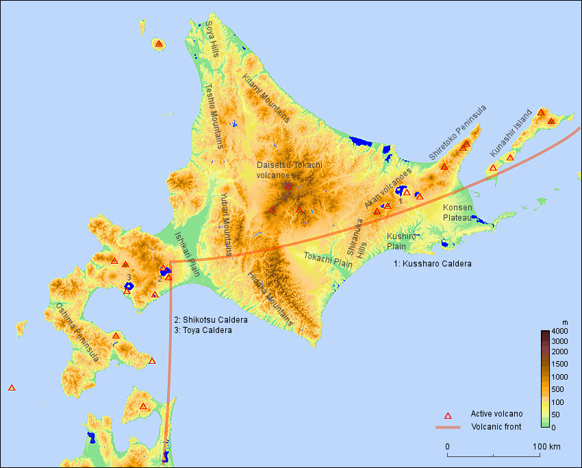
Google Maps, Meakandake (zoom in to look into the craters!)
~~~

Aerial view of Ponmachineshiri Crater as seen from the SE (Author could not be found)

Meakan: Oblique aerial view of Akan-Fuji (foreground), Ponmachineshiri (middle), Fuppushi-dake (left side behind) and Oakan-dake (right background) as seen from the SW (Author could not be found)
Caldera: Akan
Volcanoes in Caldera: Akan-Fuji, Fuppushi, Furebetsu, Meakan, Minamidake, Oakandake
This volcano: Meakan, Meakandake, Meakan complex.
Parts (cones) of Meakan: Nakamachineshiri (NE, active), Ponmachineshiri (main, active), and 7 others.
Craters in Meakan (Ponmachineshiri): Akanuma (orange crater lake in the NW [younger] crater); Aonuma (turquise pond, older crater); 1st-crater, 96-1, 3rd-crater, 4th-crater (these four youngest are at the rim of the SE [flat] part)
Thermal region: Akan-Kohan (near caldera lake Akan)
Akan is a 13 x 24 km caldera located immediately SW of Kussharo caldera. The elongated, irregular outline of the caldera rim reflects its incremental formation during major explosive eruptions from the early to mid-Pleistocene. Growth of four post-caldera stratovolcanoes, three at the SW end of the caldera and the other at the NE side, has restricted the size of the caldera lake. Conical Oakandake volcano was frequently active during the Holocene. The 1-km-wide Nakamachineshiri crater of Meakandake volcano was formed during a major pumice-and-scoria eruption about 13,500 years ago. Of the Holocene volcanoes of the Akan volcanic complex, only the Meakandake group, SW of Lake Akan, has been historically active, producing mild phreatic eruptions since the beginning of the 19th century. Meakandake is composed of nine overlapping cones. The main cone of Meakandake proper has a triple crater at its summit. Historical eruptions at Meakandake have consisted of minor phreatic explosions, but four major magmatic eruptions including pyroclastic flows have occurred during the Holocene. (GVP)

MEAKAN-DAKE Low aerial view of Nakamachineshiri Crater as seen from the NE (author could not be found)
About the names: There is a big confusion as to the craters’ names on Ponmachineshiri throughout the different reporting (and repeating) agencies. As far as I could glean from Japanese articles, craters #1 through #4 were created during a phreatic eruption in 1955. In 1996 the craters 96-1, -2, -3 were created. Yet it seems that none of these relate to the topographically obvious “holes” on top of the mountain; those are older. Currently active are the craters #1, 96-1, #3 and #4.
HISTORY
There has been quite a lot of activity in Meakandake, all eruptions in recent times were phreatic. However, at the time 500 to 2000 ya abundant lava flows have been recorded.
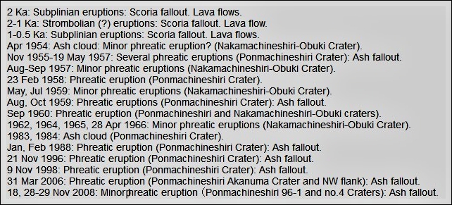
Recorded eruptions of Meakan Dake. (Screenshot from “Volcanoes of Japan” database)
If this is anything to go by, Meakan has shown a consistent pattern of precursors to its eruptions. The phreatic eruptions of recent years were preceded by increases in seismic activity, volcanic tremors, increased crater temperatures, and thermal demagnetization in the shallow areas from 1 to several months in advance of the eruption.
Oct. 1998 small phreato-magmatic eruption
Analyses of the ash found trace amounts of angular, fresh basalt fragments containing gray glass. It was considered likely that new magma reacted with water in a hydrothermal system, resulting in a phreatomagmatic eruption in which chips of solidified new magma were issued together with larger amounts of fragments of older rocks altered hydrothermally beneath the crater.
Incandescence 1999
From May to June 1999 the crater appeared bright when seen at night from a distance. Temperature measurements from July until October showed temperatures over 600°C throughout, with a high of 671°C at the 96-1 crater.
TECTONIC SETTING
Topographic map of Hokkaido (© GLGArcs)
Click to enlarge!
Hokkaido is the northernmost of Japan’s 4 main islands and lies completely on the North Amerikan/Ochotsk Plate. However, it is situated at the junction of two arc-trench systems, NE Japan and Kuril arcs, in both of which intense volcanism has continued since the late Miocene. Tectonically, it was formed by the collision of these two arcs at the central part of Hokkaido during the Middle Miocene (ca. 12 million years ago). Subduction of the Pacific Plate occurs oblique to the Kuril Trench, causing a strike-slip movement along the Kuril Arc, which results in a local collision zone within the Okhotsk Plate in central Hokkaido.
In the eastern region of Hokkaido, NE trending uplift areas with volcanoes are arranged en echelon* toward the Kuril Islands, including the Akan volcanoes, the Shiretoko Peninsula, the Kunasir Island, and the Etorofu Island. This en echelon arrangement of the uplift areas is attributed to the oblique subduction of the Pacific Plate at the Kuril Trench. The Akan Caldera belongs to the “volcanic front” which runs parallel to the Japan and Kuril trenches, i.e. E-W from the eastern region through the central region and then turns to N-S in the western region.
*The term ‘en echelon’ refers to closely-spaced, parallel or subparallel, overlapping or step-like minor structural features in rock (faults, tension fractures), which lie oblique to the overall structural trend.
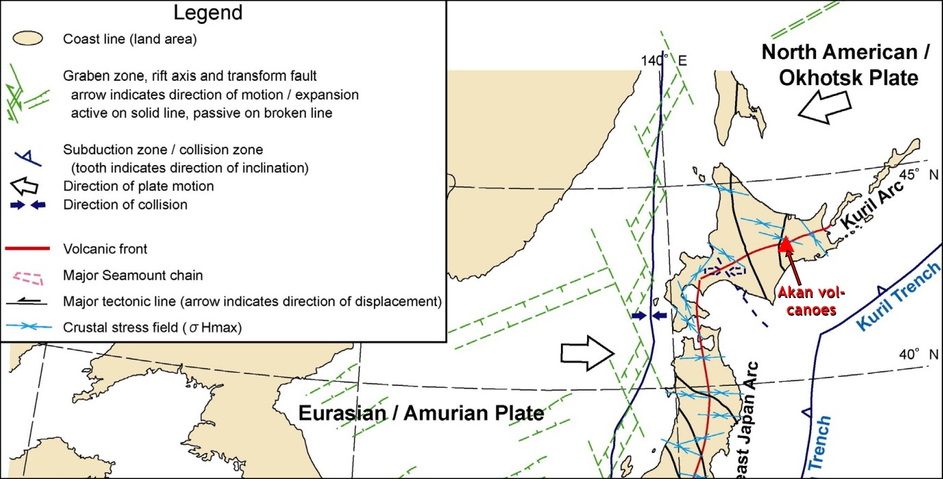
Tectonic setting of northern Japan (© NUMO)
POPULATION & VISITORS
or how do you evacuate 4,110 ants from a forest in a case of emergency
Meakandake lies in a relatively sparsely populated area. There is just the lakeside hot spring resort of Akankohan which is the only town around the lake. Then one or two villages and the National Park amenities, and… abt. one and a half million visitors to the area per year! That makes a staggering number of daily 4,110 tourists hiking, swimming, climbing, driving around in 3 national parks.
– Lake Akan Onsen area population: 1402 (as of October 2011)
– Meakan Onsen area population: 5 (as of October 2011); Moashoro area: 41
National Parks / Quasi-National Parks / Number of Climbers
– Akan National Park, Lake Akan Onsen area: Sightseers per year: Approx. 924,000
– Akan National Park, Meakan Onsen area (Onneto area): Sightseers per year: Approx. 452,000
– Akan National Park Meakandake: Mountain-climbers per year: Approx. 10,100 (June 1 to October 31, 2010)
(Akanko Ranger Office for Nature Conservation mountain-climber counter)
This lately got the authorities to develop Hazard Maps and Emergency Plans for any potential event of Meakan. It is one thing to evacuate a village, but it is quite another if you have to get thousands of tourists meandering about in the area (well, not ants, but what’s the difference?) to leave and assemble at certain points.
BESIDES THE VOLCANO
Lake Akan
in the center of the Akan Caldera is the very beautiful caldera lake, part of Akan National Park. It formed some 6,000 years ago, when a dam was created by volcanic activity. The lake used to have a clarity of 8–9 meters in the 1930s. Pollution from local hotspring resorts has decreased the transparency to 3–4 meters.
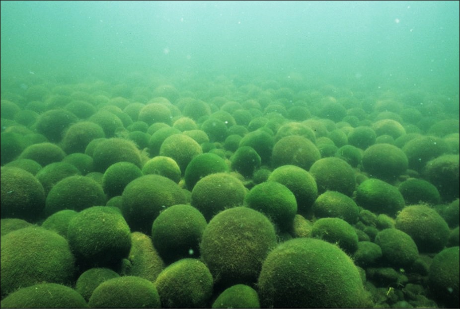
Lake Balls in Lake Akan (© Jonathan Tappan)
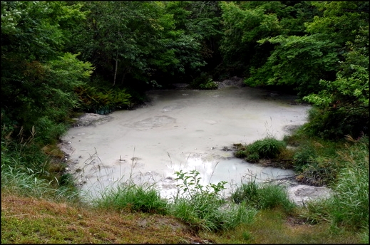
Big mud pool (© Jonathan Tappan)
Akan contains the very rare green algae Marimo (Aegagropila linnaei [Cladophorales]; engl.: Lake Ball). Marimo has an important status as a special natural monument in Japan, and is strictly protected as an endangered species in Lake Akan (as well as in Lake Myvatn, Iceland!). The algae form colonies of soft and velvety balls up to 40cm (17in) in diameter!
Then there is the Bokke Trail. Bokke?? Yes, “bokke” comes from the word “pofuke” in the Ainu language which means bubble up. Bokke are bubbling mud pools and you can see them by walking a trail alongside the lake.

Bubbling Mudpool in Akan National Park (© Arama80, Wikipedia)
Lake Onnetō
is a smaller but more scenic lake to the east of Mt. Me-akan, also in Akan National Park.
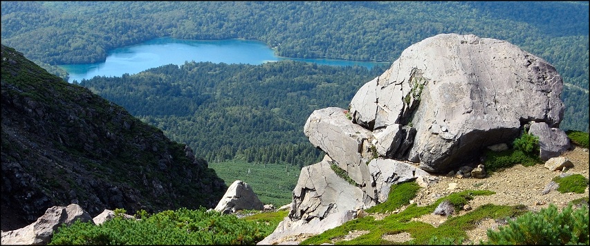
The lake of Onnetō as seen from timberline on Meakandake volcano. (© John Osaki)
Near Lake Onnetō is a hot waterfall, Onnetō Yu-no-Taki . Water of a temperature of 43 °C descends from a height of 30m. Formerly a rotenburo (a Japanese outdoors hot spring bath), its use as a bath was discontinued after it was discovered that the site and its black mud contains an important deposit of manganese. The Onnetō Hot Falls Manganese Oxide Generation Area was designated a Natural Monument of Japan in 2000.
Enjoy! -GRANYIA
SOURCES & FURTHER READING
– Monthly report Meakan 07/15 (PDF, japanese, Sapporo ..&.. Info Center)
– Report No. 33 on the status of Meakan (31/08/2015)
– Volcanoes of Japan (Database), Meakan Dake
– Introduction to the Landforms and Geology of Japan
– Tectonic Setting and Evolution of Japan (NUMO, 2004, [6])
– Meakan History, JMA
– GVP, Akan Caldera
– Meakandake (Description, PDF, engl.)
– Great photos of Hokkaido Volcanoes (website Marina Nikolaevna Rostov)


I’m bringing my last comment from the other post over here:
Sakurajima just had a sizeable explosion
http://volcams.malinpebbles.com/pubweb/Japan2.htm
Actually, Sakurajima had quite a number of sizeable eruptions the last two days, it seems she is back to her former self. There were about ten, with plume hights between 1500 m and 2000 m. Which brings the total number to 703 or over this year.
Latest eruptions here: http://www.data.jma.go.jp/svd/vois/data/tokyo/STOCK/volinfo/gensho.html
LikeLike
Photo by OVPF – thermal measurements being conducted at the Piton de la Fournaise lava flows on Sept. 03, 2015:

LikeLiked by 1 person
That’s quite a volcano, Granyia (Meakan). Impressive post, madam. Cheers –
LikeLike
While IGEPN’s daily updates on Cotopaxi are quite bland, it is really worthwhile reading their “Actualización de la Actividad Eruptiva”. They appear in longer intervals but contain a lot of interesting explanations, facts, graphs and images about the eruption. This is the latest from 2 Sept.: http://www.igepn.edu.ec/servicios/noticias/1159-actualizacion-de-la-actividad-eruptiva-volcan-cotopaxi-n-13
LikeLike
Just a note, there have been huge forest fires on G. Papandayan, which show up on the MODIS thermal imagery. I was about to cry wolf yesterday but wanted to find the assumed “eruption” confirmed first. Well, there is NO eruption, and the fires are in the news today. I suppose, large forest fires can be as bad as a volcano eruption for the people living near them, though.
LikeLike
The Piton d.l. Fournaise is still going and looking impressive. The latest report (5/9) says:
The trend of these days is maintained: The tremor remains high and we maintain the hypothesis that this increase is not related to an increased dynamism phenomenon but to a modifictaion in the supply conduit. Gas and flow rate measurements carried out remotely (gas flow walls, satellites and infrared img.) confirm this hypothesis since the observed valuesremain constant, even slightly down over the two days. On the field the same trend is visible. The eruptive cone closes more. Inside the lava lake is separated into two separate units. Fountains are less high than in previous days. The flows of lava are always at the tunnel exit located about 50 meters below the vent. This morning (September 5th 11:00) five small streams were present at the foot of the cone. Four of them were about thirty meters long. The fifth, the strongest, flowed east on a distance less than one kilometer.
The upper image from 4th Sept. shows a view into the active cinder cone, it was posted with the report. The lower is a webcam screenshot fom tonight.
LikeLike
Hi
some nice footage.
LikeLike
This is a wonderful video, thank you dfm! Tickles my (so far underdeveloped) poetic vein 😉
The Lava Stream
There it goes
It runs, it flows
It rises, it grows
It swelters, it blows
It burns, it glows
It wanes,
And goes…
Any one for a second verse?
LikeLike
It appears that a significant eruption at Aso has began.
LikeLike
Pingback: Hokkaido 4 – The Akan Caldera, Hokkaido, Japan |
Pingback: Hokkaido 5: The Tokachi Volcanic Group, Japan |
Pingback: Hokkaido 6 – Volcanoes of the Shiretoko Peninsula, Japan |
Pingback: Hokkaido 6 – Volcanoes of the Shiretoko Peninsula, Japan | | Travel Benguela