

Google Earth satellite image 11/2009
In 1916, Ernest Shackleton knew what it meant: trying to find an Island where you can see almost nothing. With four companions he sailed from Elephant Island to South Georgia in an open boat to get help for his stranded crew of the Imperial Trans-Antarctic Expedition 1914–17. In such places, where there is not much else than water, ice, rock, vog and fog, it is also nearly impossible to implement any volcano observation equipment, or even get someone to be there at the right time to take a decent picture. In the South Sandwich Islands now, there are 9 volcanoes that need watching… and one of them is Mount Michael on Sounders Island.
THE SCOTIA ARC
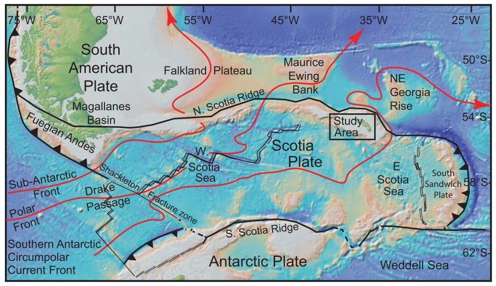
Tectonic map of the Scotia arc region, including the names of geologigal features, plate names and ocean currents (red arrow lines). Click!
…is this on satellite images so eye-catching loop of mountains and submarine ridges which extends from the southernmost Andes through the active South Sandwich volcanic arc to the Antarctic Peninsula.
Its creation began at the time when the supercontinent Gondwana broke up. Relative motion between South America, Africa and East Antarctica during the opening of the southern ocean basins resulted in an uplift of the Pacific margin cordillera, and translation of elevated crustal blocks eastward. The northern edge of the Scotia plate is bounded by the South American plate, forming the North Scotia Ridge. This is a left-lateral transform boundary with a transform rate of roughly 7.1 cm/yr. and stretches from Isla de los Estados off Tierra del Fuego in the west to the microcontinent South Georgia in the east with a series of shallow banks in between. The southern edge of the plate is bordered by the Antarctic plate forming the South Scotia Ridge, a left-lateral transform boundary sliding at a rate of roughly 7.4-9.5 cm/yr. The East Scotia Ridge, connecting the two, is a back-arc spreading ridge. It is still creating ocean crust for our Sandwich Plate.
The timing of the formation of the Scotia plate and opening of the Drake Passage have long been the subject of much debate due to the important implications for changes in ocean currents and shifts in paleoclimate. The thermal isolation of Antarctica, engendering the formation of the Antarctic ice sheet, has largely been attributed to the opening of the Drake Passage. – Today the Scotia arc with its adjacend plates serves as an excellent natural laboratory, where all sorts of tectonic processes can be studied as they still happen.
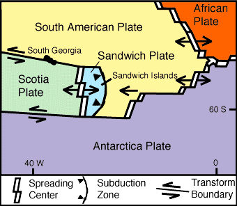
Plate motion
The South Sandwich volcanic arc system is the product of the subduction (westwards) of the South American Plate underneath the tiny Sandwich Plate which had formed by seafloor spreading between South America and Antarctica. The Sandwich Plate is less than 8 million years old. It is one of the smallest tectonic plates and it moves to the east at about 7 cm per year.
The volcanic arc on its eastern margin is younger than 5 million years. It is called the South Sandwich Islands chain. Basalts make up at least 70% of the islands, while on average, about 60% of each island consist of lava and about 40% of tephra. Eight of the eleven exhibit ongoing volcanic activity. Also, there is an active submarine vent, Protector Shoal, just 30 m below the surface. This vent erupted in 1962 and created a giant raft of floating pumice that drifted several thousand miles to reach New Zealand.
THE ISLANDS

The British Antarctic Survey runs a research station at King Edward Point, the Capital of South Georgia.
(© padreken, via Google maps)

Volcanoes on the South Sandwich Islands
South Georgia and the South Sandwich Islands (SGSSI) is a British overseas territory in the southern Atlantic Ocean. It is a remote and inhospitable collection of islands, far away from commercial shipping and air routes, consisting of South Georgia and the South Sandwich Islands, with the capital King Edward Point. There is no native population on the islands; the present inhabitants are the British Government Officer, scientists and staff of the British Antarctic Survey and the museum in Grytviken.

Grytviken harbour and whaling station, 1922. Click! – In the 19th and 20th century many of the Islands where used by “whalers”, who had established whaling stations to process their catch into a manageable size before transporting it on. (© Bee-Mason, John Charles)
Captain James Cook discovered the southern eight islands of the Sandwich Islands Group in 1775, although he lumped the southernmost three together and named the whole “Sandwich Land”. Their status as separate islands was not established until 1820. The northern three islands were only discovered in 1819. The word “South” was later added to distinguish them from the “Sandwich Islands” – the old name of the Hawaiian Islands.
THE VOLCANO

Penguins on an ice float in front of Mt. Michael/Saunders Island (© Dolph Kessler)
The South Sandwich Islands are extremely active volcanically. Mt. Michael, on Saunders Island, is roughly in the middle of the island chain. Like the other islands, Saunders is described as impossible to be explored on foot due to its rugged and deeply crevassed rocky and icy ground. Available are descriptions and drawings/photos made on excursions from a ship or helicopter, but even those cannot be obtained on more than a few days each year because of fog, rain, snow, wind and other unfavorable conditions.

Ashen Hills at the SE end of Saunders Island: an (still) undisturbed place for seals and myriads of penguins. (© Dolph Kessler)
Because of these difficulties and the remote location, there have been only three scientific expeditions to the chain. These challenges also make installing and maintaining any volcano-monitoring equipment, such as seismometers and GPS units, impractical. Only recently, satellite data have provided observations of volcanic activity in the island group, and offer the only practical means to regularly characterize activity in these islands.

Map of Saunders Island, adapted from Holdgate and Baker (1979). Lighter shaded stippled areas show rock outcrop, the remainder is snow or ice covered. Relief is shown by form lines that should not be interpreted as fixed-interval contours. (© Courtesy Hawaii Institute of Geophysics and Planetology and British Antarctic Survey)
The young Mount Michael stratovolcano dominates glacier-covered Saunders Island. The symmetrical 990-m-high edifice has a 700-m-wide summit crater and a remnant of a somma rim to the SE. Vapor emission is frequently reported from the summit crater. Tephra layers visible in ice cliffs surrounding the island are evidence of recent eruptions. Ash clouds were reported from the summit crater in 1819, and an effusive eruption was inferred to have occurred from a north-flank fissure around the end of the 19th century and beginning of the 20th century. A low ice-free lava platform, Blackstone Plain, is located on the north coast, surrounding a group of former sea stacks. A cluster of parasitic cones on the SE flank, the Ashen Hills, appear to have been modified since 1820 (LeMasurier and Thomson 1990). The biggest of them has a crater abt. 1km in diameter and 150m deep.
From GVP Bulletin reports or, How to research a volcano that is almost “invisible”
Using AVHRR data, Lachlan-Cope and others (2001) discovered and analyzed an active lava lake on the summit of Saunders Island that was continuously present for intervals of several months between March 1995 and February 1998; plumes originating from the island were observed on 77 images during April 1995 – Febr. 1998. J.L. Smellie noted that during helicopter overflights on 23 January 1997 “dense and abundant white steam was emitted from the crater in large conspicuous puffs at intervals of a few seconds alternating with episodes of less voluminous, more transparent vapour.” Smellie also observed that the plume commonly extended ~8-10 km downwind. The MODIS Thermal Alert system also detected repeated thermal anomalies throughout 2000-2002.
During the period 2002 to 2006 only very few thermal anomalies have been recorded, but on 28 Oct. 2006 an ASTER image  (picture right, courtesy of M. Patrick) gave scientists a good view of the main crater interior as there was no plume nor clouds hampering the view. The image showed a conspicuous anomaly at the summit, with numerous saturated pixels. Showing as red spots in another, colored, image are two small near-IR anomalies in the otherwise dark center of the crater. These two anomalies suggest very high temperatures and support the idea that fresh lava may reside at the surface or a shallow level in the crater. Analyzing various types of thermal images together shows that the outer crater is 500-600m wide, with a 180m(150?) high-temperature crater interior. The latter shows up as an SWIR anomaly and may indicate the rough extent of active lava flow being ~180m wide.
 Image left: For a comparison to Mt. Michael, M. Patrick chose Villarrica volcano in Chile since it presents a potentially good analogue in terms of morphology and activity style. Maximum radiant heat flux values were similar (up to ~150MW), suggesting that the maximum intensity of activity may be similar. Mt. Michael shows a much lower frequency of thermal alerts than Villarica, which may be due to more frequent cloud cover in the South Sandwich Islands or a greater depth to molten lava in the Mt. Michael crater.

Annotated Google Earth imagery of Michael volcano (Saunders Island) acquired on 19 Nov. 2009. Inset: A close up of the summit area that clearly shows steam plumes emanating from both the summit crater as well as the snow-filled ‘Old Crater’.
In late 2012, M. Patrick of USGS-HVO notified GVP Bulletin editors that images from thermal sensing satellites showed a ‘new’ active vent on Mount Michael. At closer investigation it turned out that this spot was the formerly labelled as ‘Old Crater’ which had already shown signs of activity in earlier satellite images starting in 2006. As the South Sandwich Islands are generally devoid of vegetation and habitants, and are largely ice-bound, satellite thermal alerts are strong evidence of volcanism.
An ASTER image from 17 Nov. 2010 showed apparently recent eruptive activity in Old Crater, evidenced by tephra fallout emanating from the crater and a small TIR anomaly (at the time there was also a TIR anomaly in the main crater). According to Patrick and Smellie, the plume, tephra fall, SWIR anomalies, and crater enlargement (from 150m to 190m) indicated that this vent had reactivated by late 2006.
On 6 Oct. 2015 this Landsat 8 OLI (USGS) image had one lucky shot in clear weather of our volcano, showing a red-hot glowing main crater and dark smudges on the glacier below it. This time the ‘Old Crater’ doesnt seem to be active:

6 Oct. 2015 Landsat 8 OLI (USGS): Image of incandescent crater in Mount Michael/SSI
Oh, btw., this LandsatLook Viewer is a great tool to find, customize and view various types of Landsat images! Thank you, USGS!
Two overall views of the South Sandwich Islands:

Plume from Zavodovski volcano, South Sandwich Islands, 2012 (Image: Aqua/MODIS, NASA)

The South Sandwich Islands conspired with air currents to make wave patterns in clouds. Saunders, Montagu, and Bristol Islands, part of the South Sandwich chain, all trigger V-shaped waves that fan out toward the east. The white clouds over the dark ocean water vaguely resemble zebra stripes. The South Sandwich Islands are of volcanic origin and poke their rugged summits above the ocean surface. Thus they disturb the smooth flow of air, creating waves that ripple through the atmosphere downwind of the obstacles.
There are two interesting webcams on the BAS website: one mounted on the Oceanographic research ship ORS James Clark Ross (UK), which updates every 15 minutes. The Radio Officer will usually add a small blurb containing information about where the ship is, and if you are lucky you might just see the volcanoe(s) in an image (track ship 🙂 ).
And the other is mounted on RRS Ernest Shackleton. During the Antarctic summer, it is possible to see stunning polar scenery, icebergs and mountains. During the Antarctic winter, the Shackleton undertakes survey work in the North Sea so you may catch a glimpse of an oil or gas platform. It updates approximately once every hour.
Disclaimer: I am not a scientist, all information in this (and any of my other posts) is gleaned from the www and/or from books I have read, so hopefully from people who do get things right! 🙂 If you find something not quite right, or if you can add some more facts, please leave a comment.
Enjoy! -GRANYIA

A penguin on South Georgia looks nonchalantly around. Click! (© LA(Phot) Kyle Heller, Royal Navy)
SOURCES & FURTHER READING
– HVO, VolcanoWatch Essay, Oct. 30 2008
– British Antarctic Survey
– Motion of the Scotia Sea Plates (2003) PDF
– Cenozoic tectonic history of the South Georgia microcontinent and… (2014) PDF
– Webcam mounted on the RRS James Clarc Ross
– British Antarctic Survey Scientific Reports, No. 91 PDF, p. 39 ff
– LandsatLook Viewer
– South Sandwich Islands Volcano Monitoring Blog
– Wikipedia: Index of South Georgia and the South Sandwich Islands-related articles
– http://plate-tectonic.narod.ru/scotia2photoalbum.html
– Jay Patton: Sandwich Earthquakes in Scotia


Very interesting. I am really enjoying your articles on out-of-the-way volcanos and aren’t subjects of usual writeup!
LikeLike
There are those that attempt to describe the eastern curve of the Scotia / Sandwich Plates as an impact related structure. Yet it looks a lot like the eastern end of the Caribbean Plate which was shoved thru the opening between the North American and South American plates not unlike the motion of the Scotia / Sandwich.
Great post, Granyia. Cheers –
LikeLike
thank you Granyia. I was wondering at the arc form of the island chain making a comparison with the carribean arc.
Meanwhile I found this resource on another very remote island nishinoshima, but it’s in Japanese.
http://gravireyossy.hatenablog.com/
LikeLike
Cryphia did a couple posts about curved arcs in VC July 2014. links follow. Cheers –
LikeLike
Pingback: Antarctica 1 – Introduction to Antarctica’s Volcanoes |
My remark is one of history and Captain James Cook. My curiosity started with the unknowns of the American revolution (it was supposed to be a treaty instead). Then, on to an ancient cartography of Captain Cook’s voyages, because the dates are at 1775 and before. Well, the cook on Cook’s ship is curiously the same name of present day authors of experienced, maritime cooks! I find these coincidences useful sometimes. I am sure the backstory regarding the discovery of the South Sandwich Islands by Captain Cook gets more interesting if the volcano on Michael mountain was possibly active then. That is what led me to this site. The cook on Captain Cook’s ship also has the very same name as shipping companies here in Florida! So now I want to know if this is a direct lineage up unto 2021. Were they all cooking sandwiches? They might be able to, if the volcanoes get warm enough!
LikeLike