

(© Hernan Povedano, via Flickriver)

Volcán Tromen, seen from Cerro Wayle (© Neil Pike, see Pikes on Bikes)
 Most people wouldn’t think of Argentina as a country of fire-spewing mountains, yet there is quite a list of extinct and not-so-sure volcanoes, and some can even be called outright active, although dormant at the moment. One of the latter group is Volcán Tromen in the province of Neuquén, at the northern end of Patagonia. Until two or three years ago, nobody would have thought that it could come to life again, now we learn that it has erupted just recently… I mean, a couple of centuries ago.
Tromen is an Andean back-arc volcano, part of the Tromen-Domuyo fold-and-thrust belt on the western margin of the Neuquén basin, some 150km east of the main volcanic chain that marks the border between Argentina and Chile (i.e. to the E of the Nazca-Southamerican-plate subduction zone). As the slab pushes down into the mantle it causes compression against the continental plate, uplifting and folding the old sediments into the Andes mountains. While the volcanoes of the main arc mainly formed on top of fault systems often created by extension of the crust (through uplifting), Tromen and its neighbors are thought to have grown in an area of thrust faulting – creased and folded by horizontal compression. This zone strikes oblique to the main calc-alkaline Andean orogenic belt, and its lavas strongly resemble those of intra-plate volcanics.
THE VOLCANO
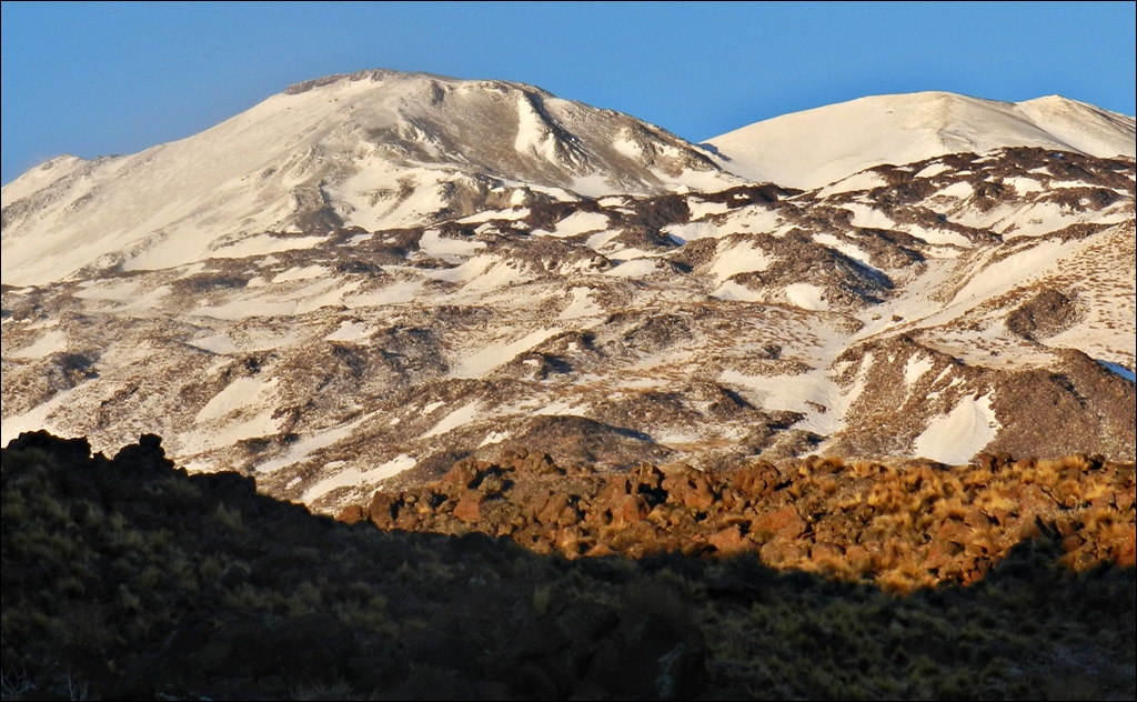
![Volcán Tromen from the NE; the dark lava flows are between 200 and 600 years old. (© Michael [segovia112001], blog <a href="https://segovia112001.wordpress.com/2014/01/02/lakes-and-volcanoes-neuquen-and-rio-negro/" target="_blank">Southbound!</a>)](https://volcanohotspot.files.wordpress.com/2016/09/tr03.jpg)
Volcán Tromen from the NE; the dark lava flows are between 200 and 600 years old. (© Michael [segovia112001], blog Southbound!)

View of the Tromen massif from the east. The Tromen volcano is the youngest and last lavas are of Holocene age. The rhyolite domes of Cerro Bayo are possible remnants of Tilhue volcano, partially covered by the Tromen lavas, suggesting that the Tilhue was a larger volcano than what is seen today. The black dashed line indicates approx. the height of the sedimentary rocks of the Neuquén Basin. (© Llambias et al., 2011)

Geological map (cropped). For full map with legend see Tromen-Tilhue Volcanic Group PDF, Llambias et al., 2011
Geologically, it is one of the youngest volcanoes of the Andes, dating from the Pleistocene; its volcanic activity started more than 2 million years ago. The structure of the Tromen massif is complex due to its long history, which began during the final deposition of the Mesozoic sediments in the Neuquén Basin. It was followed by two periods of compressional tectonics.
Tromen is located in the southern part of the Tromen Volcanic Plateau, it is the highest of several polygenetic eruptive centres in a north-south line incl. Cerro Wayle, Cerro Negro del Tromen and Cerro Tilhue. Tromen has had effusive eruptions (domes and lava flows) and may have had explosive ones as well (although the ignimbrites of the area may have been produced by another nearby volcano).

There are noumerous rhyolitic lava domes around the volcano, mainly on E-W- trending fissures which presumably formed by hydraulic fracturing in response to magmatic pressure and E-W compression. (from O. Galland et al., 2007)
Two types of Quaternary volcanism of two contrasting compositions have been recognised in the massif: rhyolitic and andesitic volcanism. The rhyolitic resulted in lava domes, lava flows and pyroclastic deposits, with ages ranging from 2.3 to 0.8 Ma, while the andesitic volcanism mainly resulted in lava flows and dykes of ages ranging from 1.9 Ma ago to the present. Both lavas of basaltic to more felsic compositions have erupted simultaneously from Tromen in several periods.

Various layers of volcanic products, from ignimbrites via lahars to lava cover the area around Tromen. This is a view from the NE, Buta Ranquil, to Volcán Tromen. (© Kathrein, via Flickriver; slightly cropped)

One of Volcán Tromen’s summit craters. (© Raul Macchi, via Panoramio)
The main crater is of ~500m ⌀, surrounded by 9 small cinder cones, some with their own craters; its slopes are covered with native sulfur. The last flows follow the current topography faithfully, they do not show erosion and end in broad lobes. They have coarse surfaces creased by pressure ridges, showing the morphology of aa lavas and blocks. The young flows went only to about 6 km from the foot of the mountain. Lava flows of basalt or basaltic andesite cover the entire edifice. However, scientists were amazed to find that Tromen is not built up entirely of volcanic materials but its core consists of a huge ridge of pushed-up Mesozoic sediments, the outcrops of which reach an altitude of 3000 m on the volcano.

Tromen. Lavas have a patina of iron oxides that lets them appear dark red or rust brown. (© The Andean Geotrail – project)
In such a compressional setting, the rising magma is expected to have formed as horizontal or gently dipping intrusive bodies or sills. It is thought that, under these conditions, Tromen volcano may not lie vertically above its deep source of magma: If magma rises along a thrust, it must move horizontally over a large distance, perhaps in the order of kilometers, which involves significant horizontal transport of magma within the crust. I’m being somewhat vague here, because there seems to be a lot of discussion on whether or not the thrust compression and E-W shortening of the crust are still happening today, if compressional or extensional forces have been at work, as well as disagreements on several other points of tectonic niceties. – Volcanology research seems to be relatively new to this area, while geologists have been in demand for a long time exploring Argentina’s rich treasures of the soil.
(© Mapucla, via Flickr)
SOME CONFUSION – DETECTIVE WORK REQUIRED!
The dilemma with historical writings

In his “Mappa Geographica…” Fr. Bernhard Havestadt marked all volconaoes he knew or saw to be active with a flame on top. This is the section of his “map” where Troman is depicted with a flame. (JCB Archive of Early American Images) Click!
Two historical eruptions are mentioned in the GVP database: in ~1751, with a VEI=3, and in 1822. Also, one v. Wolff attributed purported eruptions of Punmahuida in 1820, 1823, 1827, 1828 to Tromen without giving a source. Several researchers have wrongly interpreted a report given in the diaries (1751/52) of a German missionary, Bernhard Havestadt, as proof of a witnessed eruption. He wrote (in Spanish) about Tromen volcano: “February 7 [1752], reached Tomen [Tromen], where there is a valley and a lake [Laguna del Tromen] at the foot of two volcanoes that are called Punmahuida no doubt because the smoke it sometimes cast is thick, black and abundant, that even at noon the place darkens and turns day into night. For eight days, I had to walk over such slags [today El Escorial] with great difficulty for me and the beasts, as they ruin their hooves.” To make confusion worse, the priest had marked Tromen on his map with a flame, implying that it did erupt. However, Leandro D’elia et al., in their study of Tromen historical eruptions (2014), dismiss him having seen an eruption, saying that Fr. Havestadt had only referred to the name of the mountain, which meant something like dark mountain.
This study undertook to determine the age of the youngest volcanic products on Tromen’s NW side by looking at relative stratigraphic order, internal geomorphological differences, compositional variations and change of eruption centers. They find that the “El Escorial” blocky lavas belong to a younger eruptive cycle. Luckily they found a piece of bone buried in an older flow deposit which then could be dated to roughly 500 years old, and this puts these lava emissions in a time frame between 1400 and 1752 (when Fr. Havestadt walked over the “El Escorial”).
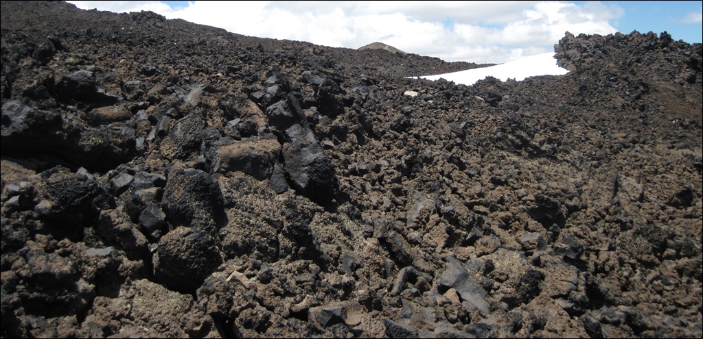
If Fr. Havestadt had to walk through something like THIS I can only sympathize with him… (© hikzer, via Flickriver; slightly cropped)
Leandro D’elia et al. also established a second eruptive cycle “between 1820 and 1828”; it is based on their results of stratigraphical, geomorphical and geochemical evidence (which on their own would not provide such a narrow time window). They supported their findings by a letter that Eduard Poeppig (or Pöppig, a very knowledgeable German naturalist/scientist who lived in Antuco town for six months in 1827/28), wrote to A. v. Humboldt.

Eduard F. Poeppig
I have done a bit of research on Poeppig, and it turns out that he has never been further east than Antuco volcano in Chile (and was the first to climb it), and Tromen lies 116 km E of Antuco. Rather, he got his information on the volcano from another missionary, and compared and completed it with oral descriptions by locals he met in Antuco. He wrote, “This is a double mountain with two craters, only one of which is active. It made a big eruption in 1822, and a smaller between 1827 and 1828. It is located in the country of the Pehuenches, along the old road from Antuco to Pampas. It was well-known to the Pehuenches.” I guess that this is also the source v. Wolff got his dates from. Well, the years could or could not be right; given that the Aborigines had no writing and only reported things from memory, some doubt should be in order. Anyway, science says, Tromen erupted between 1400 and now, perhaps several times, so it is a volcano to reckon with.
The dilemma with the names
I got very confused when trying to identify the parts of Tromen volcano. Before I started on this post I made myself familiar with the maps and learnt that Tromen consists of four main parts, from N to S:
 A. Cerro Wayle, 3,044 m;
- (Lake Tromen)
- B. Volcán Tromen, 4,114 m;
- C. Cerro Negro del Tromen, 2,821 m;
- D. Cerro Tilhue, 2,056 m

 First, I tripped over an annotated image in a scientific paper where the peaks seemed plainly named wrong. To clarify the matter, I looked up the GVP database and got still more uncertain: “The summit of Tromen is cut by two
  overlapping 3.5-km-wide calderas. The Pleistocene Volcán Cerro Negro del Tromen, with a 5-km-wide caldera, lies immediately north, and lava flows have partially overtopped the northern caldera rim“… yes, they stand out well on Google maps, dark and bare of greens. So, has the latest activity taken place on Cerro Negro d.T. then?
In contrast, another study states: “The oldest activity was recorded in the Cerro Negro del Tromen, and the most modern in the extreme north of the massif, the volcano Tromen, where Holocene lavas are found.” (J. Llambías et al., 2011). Now this seemed to be a clear message. I failed to recognise the calderas mentioned in the GVP description on a map, but clearly, they were wrong in putting C. Negro in the northern part of the massif. I found three or four images and descriptions named wrongly, and I found more than five with the names assigned as I think is right, incl. the available maps. Soo… the bucket of ash is at hand, in case I have to pour some on my head…
PARQUE PROVINCIAL EL TROMEN

Austral flamingos (Phoenicopterus chilensis) and black-necked swans (Cygnus melancoryphus) on Laguna del Tromen. (© Ricardo Alfredo Kleine Samson, via Flickriver; slightly cropped)

Natural Park Tromen: it has an area of 30,000 hectares and it protects the grassy Andean steppe and the mountains of Tromen complex. During the summer, birds use the lagoon to feed and nest. When winter comes, these wetlands are partly or completely frozen and the birds migrate northwards to warmer places. (© RioNegro.com). The volcano is Cerro Wayle.
 Researching for this post I couldn’t help marvelling about the rich wild life in this high and dry steppe & stone area, Parque Provincial El Tromen, an important wetland reservation. Although humans are warned not to use the water of Laguna del Tromen because of its acidity, there are 26 species of water fowl living on it, including Black-necked swans, Chilean Flamingoes, coots, ducks, etc.; some endangered species among them. There are eight species of reptiles, including the endemic lizard of Tromen (Liolaemus punmahuida).
Among the mammals are the Patagonian piche (Pichi, a dwarf armadillo), foxes , skunks, pumas, chinchillóns – and the pampas cat (Oncifelis colocolo), also classified as near threatened. Pampas cats are yet another small felid species that have never been studied in the wild, and this lack of knowledge makes it very difficult to develop an effective management plan to protect them. Some energetic people have dedicated their lives to research and education about this beautiful but elusive wild cat of the Andes:

Click on the image to see the “Cat in Thin Air” project website. Or read the blog post “In Search of the Wild Cats of the high Andes“.
~~~
Disclaimer: I am not a scientist, all information in this (and any of my other posts) is gleaned from the www and/or from books I have read, so hopefully from people who do get things right! 🙂 If you find something not quite right, or if you can add some more facts, please leave a comment.
Enjoy! – GRANYIA
SOURCES & FURTHER READING
– GVP, Tromen
– Historical eruptions of the volcano Tromen: geomorphological and […] (2014, Spanish)
– Crustal collapse in the Andean backarc since 2 Ma: Tromen volcanic plateau (2008)
– Volcanism in a compressional Andean setting: A […] study of Tromen volcano (2007)
– Tromen-Tilhue Volcanic Group (2011, PDF)
– Volcan Tromen (Blog The Earth Story)
– The Andean Geotrail – project
– “Volcanoes of Patagonian Argentina – 1 – Tromen” (Earth of Fire, Blog)
– “Coeval volcanic activity and tectonic shortening, Tromen volcano, Neuquén province”
– Havestadt’s “Mappa Geographica…”
– Maravillas del Tromen (RioNegro.com)
– Parque Provincial El Tromen
– In Search of the Wild Cats of the high Andes (blog post)
– Cat in Thin Air


Howdy Granyia – fascinating post. I am amazed with the local penchant to give a discrete name to every single high point on a volcano. We saw it with Nevados de Chillan. The Russians do the same thing on Kamchatka. Difficult to keep up as there are so very many high points. Cheers –
LikeLike
Awesome article! 🙂 Very fascinating area indeed, thank you!
(btw. mid-sized Popocatepetl explosion on webcams right now, plume is a couple of kms I think)
LikeLike
Thank you both, Tom and agimarc! And drat, I have looked about three times at the cams today, only to find Popo, all of Kamchatka and La Reunion completely wrapped in clouds, then I went downtown… we should have a device on our mobile phones that makes them ring when a volcano starts erupting and opens the appropriate webcam view ! 😀
What else happened today? Last night, Piton de Fournaise considerably incresed its activity, but nobody could see it for fog or vog (left image is from yesterday’s fountaining). Then suddenly, it decided it has had enough – and stopped. Completely.
In Central-America, Turrialba and Santiaguito each had ash explosions again:
LikeLike
Over the weekend (Sat/Sun) 14 earthquakes happened in the Bárðarbunga area (Iceland), two of them tonight within half an hour: a M 3.8 and a M 3.7. I went to Jon Frimann’s page to see his opinion about them. Jon says, there is nothing out of the usual with them, and he doesn’t “expect this to change until it does” – well, I fully agree with him on that point.
LikeLike
Just if you wonder… Klyuchevskoy is still going strong! Report 15/9: Explosive-effusive eruption of the volcano continues: there are bursts of volcanic bombs above the summit crater and above the cinder cone into Apakhonchich chute, and strong gas-steam activity of two volcanic centers with emission of different amounts of ash, and the effusing of lava flows along Apakhonchich chute at the eastern flank of the volcano, and at the south-western its flank. On satellite, a large bright thermal anomaly was observed in the area of the volcano all week; on 10, 13 and 15 September explosions sent ash up to 7 km a.s.l. and ash plumes extended for about 50 km to the south-east and north-east from the volcano.
LikeLike
That reminds me of one of my favorite volcano-questions: I have learnt what forces can cause the onset of an eruption – but what makes them last for either a brief stint of a few days or a many-month-long period (in the same volcano)? Sure, pressure, temperature, composition play a role, but what exactly causes the difference? Does the magma reservoir underneath change size all the time? Or, if exhausted, does sometimes more magma come up from the mantle, and sometimes not, and if so, why?
LikeLike
Turrialba is currently erupting again.
LikeLike
guess I was a bit late to the party: https://www.bluewin.ch/de/news/vermischtes/2016/9/20/vulkan-turrialba-in-costa-rica-bricht-aus.html but ash was still billowing from it today on the webcam.
LikeLike
Hi Bruce, no, you were right, the last message by RSN on Twitter was 2 hours ago, saying (roughly): “From 9:48 am began an eruption of greater size to the ones observed during the morning, still is in course #volcánTurrialba”
LikeLike
Great video footage of the (or an) eruption in that article you linked to, thanks!
LikeLike
Turrialba is really working its legs now (12:15 CET, 10:15 UTC)! The webcam image is rather dark, but the plume seems to reach 3k or so..
LikeLike
Yes, wow, look at the crater cam right now, throwing incandescent stuff!
LikeLike
Wow indeed. And thats a lot of ash – not good news for the people living nearby it or the air traffic at the CR int’l airport…
LikeLike
LikeLike
Getting daylight now…
LikeLike
From Twitter: Ash accumulation from Turrialba volcano is already affecting streams and rivers. So in the Toro Amarillo River near Guapiles with increased acidity and gray mud on the banks. This could result in impairment to aquatic life, agriculture and livestock that obtain water from this river, as had happened in 1865. And the last image from the webcam is this:
(What do we need electron-microscopes for, if we get it all on webcam? 😉 )
LikeLike
Seven international volcanologists are travelling in PNG these days to monitor and research active volcanoes of New Britain and Bougainville. Tough job, I think, and great, as there is so little monitoring done. They tweeted an actual image of Bagana:
LikeLike
Yesterday, 375 members of the National Academy of Sciences, including 30 Nobel laureates, published an open letter to draw attention to the serious risks of climate change. The letter warns that the consequences of opting out of the Paris agreement would be severe and long-lasting for our planet’s climate and for the international credibility of the United States.
http://responsiblescientists.org/
LikeLike
Respectfully disagree. This is pretty good reading. Cheers –
https://wattsupwiththat.com/
LikeLike
Hi agimarc, not to unleash a discussion about GW, which is done to overkill in other places, but just a very personal note concerning myself:
I am not a climate scientist, so I (plus 99.9% of the world’s population) am not in a position to valuate such scientific findings. I did read the essay you linked to, but to me it was just another scientific text. What is that to me? Should I go and measure the temperatures myself and do some modelling to either confirm or dismiss their findings? Or am I required just to *believe* what they say?
Common sense tells me that, if there is only a chance that one party could be right and GW could happen, then I will do anything I can to prevent it. I have family, grandchildren, and I don’t want them to perish in storms, floods, heat or whatever. Well, there is a chance the GW party *could* be right, so I am on their side. That is what I understand by “responsible”. To just sit hands in lap and wait who turns out to be right I would call “irresponsible”, because it could be too late then.
And, btw., what is wrong with stopping to pollute the world anyway?
LikeLike
Howdy Granyia –
I am allowed a single response and will stop after this.
The WUWT site has a variety of stuff on it. All highly educational. If nothing else you will get a feel for the sheer complexity of what they are trying to predict.
Personal from my end. I am old enough to remember the Next Great Ice Age scare of the 1970s. Now manmade global warming due to CO2 emissions is the current scare. My education is engineering so I pay close attention to data. When I see government-funded data hidden from the public, changed after the fact, or simply made up, I start worrying. I also read a large chunk of the Harry Read Me e-mails out of the University of East Anglia’s Climate Research Unit and was appalled. If this is real, why do they have to make stuff up? NOAA has been massaging global temperature data for two decades – mostly decreasing historic temps and increasing newer. This is done to show an upward trend.
Final point, satellite data has the global temperature stable, unchanged for the last 18 years. During that entire time CO2 levels in the atmosphere have slowly increased. The instant temperature increases decoupled from CO2 levels increases was the instant the theory was disproven. And throughout this entire argument, nobody talks about the sun, which is at the moment pretty quiet, which also worries me.
I personally and professionally reject the notion that CO2 is a pollutant. It is plant food, required for life on this planet. There are geologic CO2 levels 10 times current levels (over 4,000 ppm) and life did just fine.
Like you, I want to clean things up, but believe the best way to do it is to make as many people as possible on this planet wealthy, free and with access to unlimited amounts of reliable energy. Throughout history, the richer we get, the cleaner we get. Not a fan of the precautionary principle, as it is almost always used as an excuse for government intervention of some sort. But that’s just me. Cheers –
LikeLike
Ah, here is something I can agree wholeheartedly with: We need a new definition for MAGMA!
“Confusion over the meaning of “magma” can generate popular misperceptions, including a nonexistent molten sea underneath Yellowstone National Park…”
https://eos.org/opinions/we-need-a-new-definition-for-magma
LikeLike
Turrialba erupting again this morning (11:27UTC). From the helicorders, I suspects its been going on for a while already, but the visibility has been low and the webcam near the crater has been offline for a while.
LikeLike
(Indeed, local news seems to confirm that this has been going on continuously for 17 hours straight: http://www.crhoy.com/nacionales/volcan-turrialba-lleva-17-horas-de-erupcion/)
LikeLike
mukejrhgiu
tnbjhigerggrigjigi-prgr
LikeLike