

Plosky Tolbachik eruption in 2012 http://www.digitaljournal.com/article/339347
Tolbachik is a pair of volcanoes at the southern end of the Kliuchevskaya volcano group on the Kamchatka peninsula, Russia. They erupt primarily basalt and andesitic magmas. One of the pair, Plosky Tolbachik is a shield volcano topped with calderas up to 3 km in diameter. The other, Ostry Tolbachik is a stratovolcano that has evidence of at least one flank collapse.
Plosky Tolbachik was the location of two of the largest effusive basaltic eruptions over the last century, matched only by the output from Holuhraun in Iceland in 2014.

Tolbachik flank showing cinder cones http://volcano.si.edu/volcano.cfm?vn=300240
It is a relatively unpopulated area with only about 10,000 living within 100 km of the group.
KVERT is the government monitoring organization. Their home page is here: http://www.kscnet.ru/ivs/kvert/index_eng.php
The Tolbachik home page is here: http://www.kscnet.ru/ivs/kvert/volc.php?name=Plosky%20Tolbachik&lang=en
Tolbachik webcam is located here: http://geoportal.kscnet.ru/volcanoes/volc.php?ln=vid&name=Plosky%20Tolbachik

Map of Kliuchevskoi volcanic group http://volcano.si.edu/showreport.cfm?doi=10.5479/si.GVP.BGVN201212-300240
Kliuchevskaya Volcano Group
The Kliuchevskaya (sometimes spelled as Klyuchevskaya) Volcano Group is located almost directly above a triple junction as the Pacific Plate subducts below the North American and the Okhotsk Plates. Also being subducted are the Emperor Seamount Chain. This provides a prodigious magma supply.
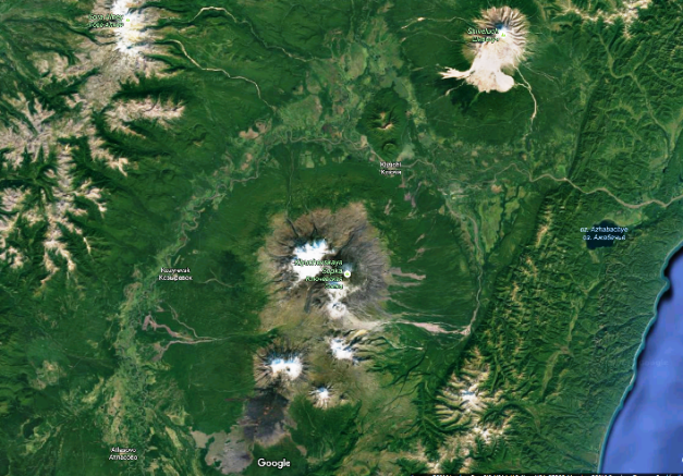
Google Maps screen capture of Kliuchevskaya volcano group with Shiveluch in the NE part of the picture
The group includes Ushkovsky, Klyuchevskaya Sopka, Kamen, Bezymianny, Zimina, Udina and Tolbachik. South of the group is Kizimen. North of the group are a pair of dormant, flank collapse volcanoes just north of the village of Klyuchi and finally Shiveluch. The entire group is littered with flank collapses, lateral blasts, effusive eruptions and massive pyroclastic flows. It measures roughly 20 km by 40 km, with the long axis generally north – south. Kizimen is some 78 km to the south of the group. Shiveluch is some 80 km to the north of the group and marks the northern end of Kamchatka volcanic activity.
Here are some thumbnail sketches of the volcanoes listed above.

Shiveluch eruption Sept. 2014 http://thewatchers.adorraeli.com/2014/09/25/powerful-eruption-observed-at-shiveluch-kamchatka-russia/
Shiveluch fills a 9 km diameter caldera breached to the south. It is one of Kamchatka’s largest and most active volcanoes. It is active with over 60 eruptions in the Holocene. A very dangerous mountain. https://volcanocafe.wordpress.com/2012/09/03/shiveluch-the-bad-boy-of-kamchatka/

Volcanoes north of Klyuchi, Kamchatka, Russia. Google Maps screen capture.
Volcanoes north of Klyuchi show up on the map as a pair of craters out of same edifice. The horseshoe in the southern volcano points generally SE while the horseshoe amphitheater on the northern volcano points generally N. They appear to be unnamed at least on the maps I found. The cones are well eroded, indicating a significant period of inactive time.
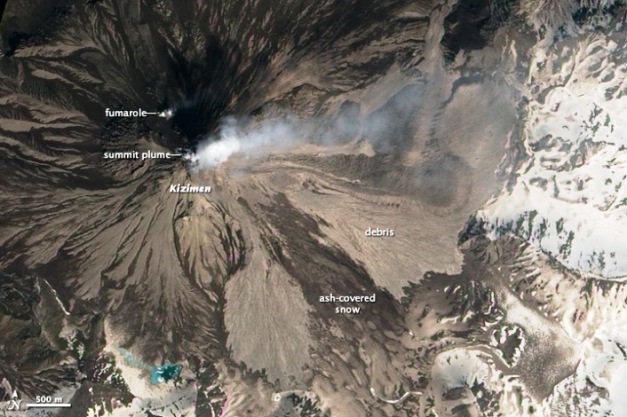
Kizimen from space. NASA. May 2013. http://earthobservatory.nasa.gov/NaturalHazards/view.php?id=81235
Kizimen, south of the group is described as morphologically similar to Mount St. Helens before the 1980 eruption. It tops out at over 2,300 m. The volcano is relatively young thought to be around 12,000 years old. There is evidence of at least one lateral blast creating a 1 km crater breached to the NE. It is currently in dome-building with the occasional dome collapse. http://volcano.si.edu/volcano.cfm?vn=300230

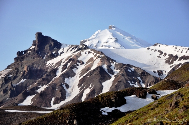
Ushkovsky volcano. http://www.volcanoesland.com/attractions/ushkovsky/
In the group itself, Ushkovsky is the NW corner of the grouping. It consists of two massive stratovolcanoes. Ushkovsky (Plosky) is nearly 4,000 m high, topped with a 5 km diameter caldera. Adjacent is a complete stratovolcano, Krestovsky (Blizhny Plosky) which is some 4,100 m high. There are lines of cinder cones down the flanks and into the lowlands. The most recent eruption from Ushkovsky was 1890. Two massive eruptions have been confirmed some 6,670 and 7,550 years ago. http://volcano.si.edu/volcano.cfm?vn=300261

Klyuchevskaya Sopka in eruption 2013 http://shutupandtakemethere.com/klyuchevskaya-sopka-stratovolcano-in-kamchatka-rus.html
Klyuchevskaya Sopka is some 11 km to the east of Ushkovsky. It is another stratovolcano, this one over 4,800 m high. The volcano is thought to be some 6,000 years ago and has been in near continual eruption since its formation. The USGS reports that over 100 flank eruptions have taken place over the last 3,000 years. There are 71 observed eruptions since 1900 alone, so the previous number is likely to be low by a wide margin. This volcano has not yet had a caldera forming eruption. http://volcano.si.edu/volcano.cfm?vn=300260

Kamen volcano (center) showing remains of flank collapse. http://www.volcanoesland.com/tours/climbing-klyuchevskaya-sopka-kamen-volcano/
Kamen is slightly to the south of Klyuchevskaya and forms the middle of a short chain of three volcanoes. It has not been recently active but did suffer a major flank collapse that sent 4 – 6 km3 of debris over 30 km to the SE. The remaining mountain tops out at just under 4,600 m. Activity at Kamen is thought to have begun in the late Pleistocene and continued into the Holocene. The GVP does not list any known eruptive activity. http://volcano.si.edu/volcano.cfm?vn=300251
Eruption of Bezmianny in 2012. http://inthecompanyofvolcanoes.blogspot.com/2015/06/the-volcano-rock-stars-of-kamchatka.html
Bezymianny is a young volcano that marks the end of this 9 km long chain. It was formed some 4,700 years ago over an ancestral dome complex and edifice built some 7,000 – 11,000 years ago. There were three periods of activity over the last 3,000 years. The most recent period that began in 1955 broke a 1,000 year period of quiet. The 1955 eruptive period climaxed with a Mount St. Helens style eruption that produced a horseshoe shaped crater and lateral blast. The crater has been mostly refilled with ongoing dome growth, intermittent explosive activity and pyroclastic flows. The 1955 eruption was classed as a VEI 5. http://volcano.si.edu/volcano.cfm?vn=300250
Zimina is a pair of eroded stratovolcanoes some 13 km south of Bezymianny. The larger volcano tops out at just under 3,100 m. Both are topped with icecaps. The southern peak produced a flank collapse debris avalanche the traveled over 10 km. This collapse does not appear to be connected to a lateral blast. There are no known historical eruptions from Zimina. http://volcano.si.edu/volcano.cfm?vn=300242

Udina volcano in foreground. Zimina in the background. http://volcano.si.edu/volcano.cfm?vn=300242
Another 12 km SSW from Zimina we find Udina volcano. This marks the southeastern end of the volcano group. Udina consists of two stratovolcanoes constructed along generally an E – W line. The western volcano is called Bolshaya Udina and is over 2,900 m high. It is generally andesitic and has a large lava dome on its SW flank. The eastern volcano, Malaya Udina is generally basaltic and tops out at over 1,900 m. It also has small domes on its flanks. There are no known historic eruptions from Udina. http://volcano.si.edu/volcano.cfm?vn=300241
One thing to note about the group, is that the magmas tend to change from andesitic to basaltic as we work our way south from Shiveluch. The two southernmost volcanoes Udina and Tolbachik have significant basaltic components.
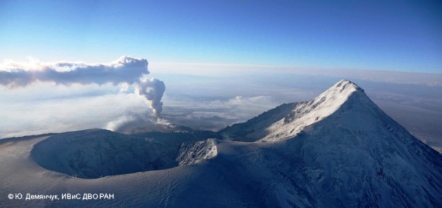
Tolbachik eruption in 2012 http://volcano.si.edu/volcano.cfm?vn=300240
The final volcano in the group is Tolbachik. It is some 15 km NNW from Udina. Like Zimina and Udina, it also consists of a pair of cones. The shared edifice supports two different volcanoes. Ostry Tolbachik is a stratovolcano topping out at some 3,600 m. The second volcano is a basaltic shield called Plosky Tolbachik. It is topped with nested Hawaiian-style calderas (likely subsidence) measuring up to 3 km in diameter. Ostry Tolbachik had a flank collapse generally south some 6,500 years ago. The flank collapse took place about the same time as a major effusion eruption from Plosky Tolbachik. There are rift zones that have eruptive large quantities of basalt, with the 1975 – 1976 eruption being the largest historical basalt eruption in Kamchatka. A similar eruption took place from 2012 – 2013. http://volcano.si.edu/volcano.cfm?vn=300240

Tolbachik eruption Dec 2012 http://www.dailymail.co.uk/news/article-2245648/Plosky-Tolbachik-volcano-erupts-NASA-satellite-captures-red-hot-lava-flowing-Russia.html
Eruptions
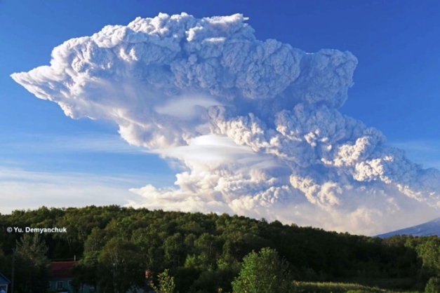
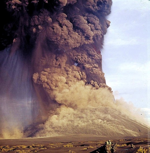
The 2012 – 2013 was classed as a VEI 4 eruption due to the quantity of basalt erupted. It was an effusive eruption that started with Strombolian activity and climaxed in November 2012. During the initial phase, there was strong explosive activity that put a plume some 10 km high. Ashfall up to 4 cm was measured some 65 km away. After a few days, the eruption settled down to a more effusive nature, with lava eventually flowing some 10 km from the volcano. Total volume erupted was some 0.55 km3. https://volcanocafe.wordpress.com/2013/06/01/tolbachik/
Tolbachik 1975 eruption https://04varvara.wordpress.com/2012/11/21/21-november-2012-our-great-russian-motherland-tolbachik-volcano-in-kamchatka-photo-by-vadim-gippenreiter/00-vadim-gippenreiter-tolbachik-volcano-1975/
The 1975 – 1976 eruption similarly combined an explosive start with an effusive end. In the end, it produced just under 1.2 km3 of basalt. It also produced around 0.7 km3 of tephras. Eruptive plume was measured over 13 km high. Basaltic lavas covered over 40 km2 of area. The eruption also created four new monogenetic cinder cones along the open rift. http://volcano.oregonstate.edu/tolbachik
There are numerous eruptions in the 20th century most of them in the VEI 2 – 3 range. Historic eruptions do not appear to be much larger than VEI 4.
This is a prodigious volcano that has produced significant basalt lavas over the last ten thousand years.

Schematic of Kamchatka triple junction http://earthjay.com/?p=3938
Tectonics
As mentioned previously, Tolbachik and the larger Kliuchevskaya Volcano Group sit very close to a triple plate subduction junction. Tectonics of Kamchatka were covered on a previous post on VH. For additional reading, the link takes you to the article. https://volcanohotspot.wordpress.com/2015/03/18/tectonics-of-the-kamchatka-peninsula/
The subduction provides a prodigious supply of magma for surface activity. In the case of this group, the magmas appear to be well mixed, though the composition changes regionally from andesitic to basaltic as you move south across the group.
Magma for Tolbachik appears to be supplied from a reservoir some 20 km below the volcano. It is held briefly and mixed in a region some 5 km below the eruptive rifts. The 1975 eruption had a third reservoir just below the surface that was filled when portions of the caldera at the top of the volcano collapsed a bit. The shallow chambers appear to be transient while the 5 km chamber appears to be long lived.
Magma for the 2012 eruption appears to come exclusively from around 5 km deep.
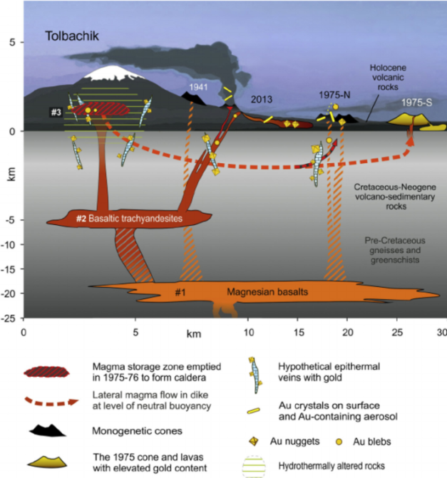
Schematic of plumbing system under Tolbachik https://www.researchgate.net/figure/290437867_fig7_Fig-7-The-magmatic-system-under-Tolbachik-volcano-and-possible-mechanisms-of-gold
Interestingly, Tolbachik erupts two different types of basalts – high aluminum and high magnesium basalts. The chambers are hot, well mixed and regularly resupplied from new magmas below.
The old Volcano Café had a post that argued that volcanic activity in Kamchatka was driven by flat plate subduction. I believe this to be a bridge too far, as flat plate subduction, particularly the rollback when it starts moving back down into the mantle is more often than not tied directly to massive caldera formation, something we have yet to see in this portion of Kamchatka. The volume of dehydrating Pacific Plate debris and the Emperor Seamount chain being subducted appears to be quite enough to provide both the magmas and volatiles dissolved in them erupted and mixing below the surface. https://volcanocafe.wordpress.com/2013/06/03/central-kamchatka-depression/

Schematic of lava coverage from 2012 eruption https://www.researchgate.net/figure/277726239_fig1_Fig-1-Con-fi-guration-of-the-monitoring-system-for-the-Klyuchevskoy-volcano-group-in
Conclusions
This area is quite young and quite active. The volcanoes grow quickly and collapse just as quickly, more times than not without benefit of a lateral blast eruption. There are several amphitheaters from lateral blast eruptions. There are even summit calderas like we have seen in other subduction driven front arc volcanoes. Given the significant amount of melt powering four continuously erupting volcanoes, I believe this will continue to be one of the more dangerous active volcanic regions on the planet.

Lava flows from 2012 Tolbachik eruption http://russiatrek.org/blog/nature/the-eruption-of-the-volcano-tolbachik-in-kamchatka/
Additional Information


Great read agimarc!! Crazy bit of the planet that corner. I don’t think we should be too worried about the absence of calderas .. Shiveluch has one and there are some biggies further south. It also looks like the active front is sidestepping towards the plate margin (roll-back) and maybe the Kluichevskoi group is still a bit too young to go full caldera on us just yet.. Obviously with all that basalt in the southern part of the group, there is not a lot of magma storage going on at shallow levels to rejuvenate crustal material (i.e. it is just shunting straight up from the deep source, like you explained). Maybe Plosky is the best candidate for a large caldera eruption as activity moves eastwards and the volcano has a long enough repose time for felsic magmas to evolve.
LikeLike
Howdy Bruce – Hope all is well with you and yours. Thanks for the comment.
One of the things I haven’t explored is why the line of active volcanoes has migrated east across Kamchatka. As I look at the maps, the current front is the third and youngest line. In the group itself, it almost seems like the general movement of activity is slowly southbound, though as young as the group is, and as spread out as the 4 currently active volcanoes are, that may be a distinction without a difference or splitting hairs.
Ushkovsky already has a 5 km caldera on top of it. I expect 2 – 3 of the active stratovolcanoes including Shiveluch are future possibilities. What I was thinking of when talking about ignimbrite outbreak and caldera formation was multiple nested 20 – 40 km diameter calderas like we saw in Colorado and the Andes. We see some of this farther south in Kamchatka but not this far north yet. Have no idea what it means other than more clues to something.
It is one of the more fascinating groups I have come across. Thanks again. Cheers –
LikeLike
One of my bucket list excursions is a bit of trout fishing in Kamchatka. If the group can hold off large caliber festivities until that trip is done, I will be a happy fat man. Cheers –
LikeLike
Hi all, no sooner had I left my computer for a week than things got lively in the volcano world! 😉 Thanks agimark for your post on the most interesting volcanic area in the world (in my opinion); and here are some news from the past 8 days:
+++ On Tuesday, 27/09, Rinjani had a short-lived 2000m-ash-eruption which nevertheless caused the closure of several airports in Lombok and eastern Java. Authorities tried hard to evacuate the more than 1000 tourists in the area but, would you believe it, a number of them hid in the bushes in order to take great eruption photos…
+++ An Aqua MODIS satellite image from Thursday, 29/09, shows the plumes of three erupting volcanoes in the South Sandwich Island chain: Zavodovski, Mount Michael and Bristol Island:
+++ Due to the unusually high level of unrest at Katla IMO set the aviation colour code from green to yellow on Friday, 30/09. An intense earthquake swarm had begun on 29/09. Civil Protection also closed the road to Sólheimajökull glacier and it was forbidden to walk onto the glacier. Jon Frimann writes on Sept. 30: “During the last 48 hours a total of 261 earthquake has happened in Katla volcano. Largest earthquakes during the last 24 hours had magnitudes of 3,1 and 3,2. The largest earthquake had the magnitude of 3,6.” – All restrictions have been removed today as the swarm had ended. As no harmonic tremor has been detected it is not thought the seismic activity was connected with a possible eruption of Katla.
+++ Turrialba threw out ash on and off all week, which is becoming a nuisance for water supplies and agriculture.
+++ In Mexico, volcan Colima began shedding its current lava dome over the weekend, with a 4-km-plume, pyroclastic flows and lava eruptions so strong that some nearby villages had to be evacuated.

The eruption is still going on, GIF images from last night:
+++ On Sunday, 02/10, a considerable earthquake swarm of around 100 quakes with magnitudes between 1 and 2 occurred on the Canarian island Teneriffe. INVOLCAN have published a statement today saying that the quakes very probably had been connected with the hydrothermal system below volcan Teide. http://www.involcan.org/noticias/
+++ Also since yesterday one of our usual customers is showing strong activity, namely Fuego in Guatemala:
+++ In spite of INETERS’s continued reports of low gas- and steam emissions, Momotombo (Nicaragua) has been showing quite strong plumes recently. This from today:
+++ This afternoon, 03/10, Ubinas in Peru finally had an ash eruption, which had been expected for a while by the unrest at the seismograms for the last couple of weeks:
+++ And here are new pics of sprites, generated by the hurricane Matthew. They “were located about 400 miles southwest of my location in Cabo Rojo, Puerto Rico,” wrote Frankie Lucena, who also captured the sprites in a YouTube video (https://www.youtube.com/watch?v=all0IAXa2UA).
LikeLike
This is the latest webcam aquisition on the EMSD website: view from Бульвар Пийпа in Petropavlovsk to the volcanoes Koryakskaya sopka (left) and Avachinsky, 20 km NE of the town.
LikeLike
Mount Meager, Canada? Hmm…
http://www.whistlerquestion.com/news/local-news/volcanic-activity-detected-at-meager-1.2357225
LikeLike
Popo shows increased unrest/harmonic tremor for the last 8 hours or so http://www.ssn.unam.mx/sismogramas/ppig/ and https://twitter.com/Popocatepetl_MX/status/783465940432195585/photo/1
LikeLike
Thanks for the interesting article agimarc, very active region indeed!
LikeLike
The old story new…
LikeLike
Looks like IGN is up to its old tricks. Keep this up and someone is going to get hurt. Cheers –
LikeLike
Agimarc:
Dfm retweeted this to us with the remark: “@volcanohotspot: something for agimarc!😊”
| Oct 6 is anniv of #Augustine 1883 eruption. VEI4, debris avalanche, tsunami – read more http://bit.ly/2e5tJHd | From this page I found a link to this interesting paper on Augustine: http://pubs.usgs.gov/pp/1762/
Do you know how to access the images/items that are icons for resources on the AVO library pages?
LikeLike
Howdy Granyia – Thanks to dfm for the reminder. Knew about the 1883 debris avalanche. Didn’t know that Oct 6 was the anniversary date. From the AVO description:
“The irregular coastline of Augustine Island is due to the repeated catastrophic collapse of the summit dome, forming debris avalanches down the flanks and into Cook Inlet. At least 11 avalanches have occurred in the past 2000 years with an average recurrence interval of about 150-200 years [2] [3].”
All I do is to click on the links for images / documents to find them. You can then click on the images themselves to see them. Usually a high res version is available.
The docs are a bit more problematic, as some are not available from AVO. Usually, I open another tab and giggle the title to find them. At worst, I get the abstract. Cheers –
LikeLike
New post is up 🙂
LikeLike