
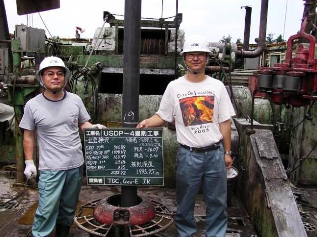
Drilling completion day! (Photo: ICDP, Image of the day – 2004/07/07)
Following the destructive, deadly series of volcanic eruptions at Unzen from 1990 – 1995, the Japanese needed to understand the eruption mechanisms better so as to better predict its future behavior. They started the Unzen Scientific Drilling Project (USDP) in April 1999. This project proceeded in two drilling phases completed in 2003 and 2004 respectively.
The first phase defined the well design and targets of the drilling.
The second phase penetrated the magma conduit feeding the current dome at the summit of the volcano.

Drill rig in place for Phase 2 of drilling 5/14/2004 (Photo: ICDP)

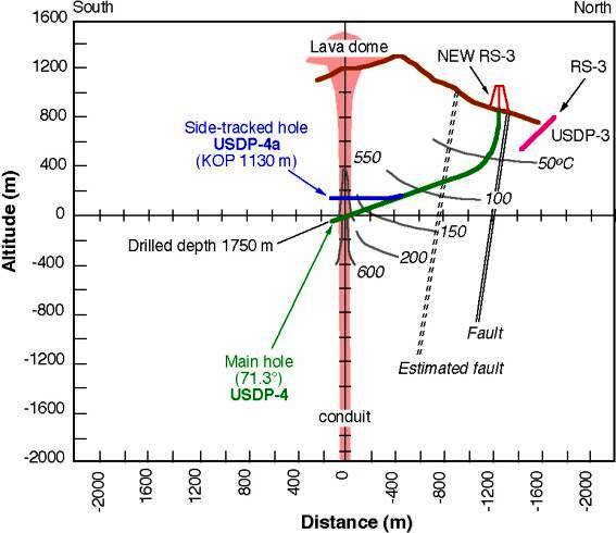
3-D cross section of Unzen showing location of well, seismic activity and target of drilling (Image courtesy of the Unzen Scientific Drilling Project)
The scientists wanted to characterize where the magma was effectively degassing, as they believe that this is the major factor that controls the eruption styles. Styles are dependent on pressure dependent solubility of volatiles, mostly water, which accelerates frothing of the magma as it approaches the surface. The degassing creates earthquakes which in turn define the place where water depressurizes sufficiently to flash to steam and drive explosive eruptions.
The project was the first on site observation of Unzen’s conduit and surrounding rock walls following a recent eruption.
Participants and Partners
The project was funded by ICDP Germany – the German Science Foundation, International Continental Scientific Drilling Program, and the Japanese Government. Principal investigators included four Japanese scientists and a professor from USGS in Fairbanks. Partners included the University of Tokyo, National institute of Advanced Industrial Science and Technology, University of Alaska, German Research Centre for Geosciences, Japan Metals and Chemicals Co., Ltd, and Kyushu University.
As of today, drilling operations are finished, the well capped, and scientific evaluation complete.
The majority of what follows is paraphrased from “Scientific Results of Conduit Drilling in the Unzen Scientific Drilling Project” by Setsuya Makada, Kozo Uto, John C. Eichelberger and Hiroshi Shimizu dated Jan. 3, 2005.
Side schematic of drill hole and location of rig http://www.eri.u-tokyo.ac.jp/KOHO/Yoran2003/sec4-5-eng.htm
Drilling Operation
Geothermal modeling before drilling began suggested a temperature over 600 C in the center of the conduit if it cooled by conduction only. Drilling target was the center of the region of tremors that occurred prior to magma extrusion in 1991. Drilling began some 840 m above sea level and 1000 m north of the summit of the Fugen dome on Unzen. Drilling was planned directionally with the initial run vertical with a turn toward the summit as the intersection depth was below sea level. Precision direction of a drill is a common practice in oil and natural gas drilling and requires what is nowadays common equipment and expertise.
This required preparatory work on the volcano itself included a new road up the mountain, water wells and a water pipeline. As the drilling operation was water-cooled, a significant amount of water was required for active drilling.

Display of bits used during drilling operation http://jnadleman.net/Japan/museum.html
The drilling team expected problems with trajectory control in loose volcanic formations during the large diameter phase and drilling, sampling and logging efforts within the anticipated high temperature formations. What they found were cavities in the formation that made it difficult to meet their drilling schedule. They initially were sited in a small basin associated with an active fault on the flank. They lost drilling mud circulation, suffered frequent wall collapse and had deviations in trajectory. These were solved by changing to an aerated drilling mud with more water and a top drive system. These increased their ability to control direction and vector of the drill. The paper also mentions a safety and oversight committee for conduit drilling that improved positioning.
Drilling resumed in 2004 with the target changed by 250 m East based on reanalysis of seismic data taken during phase 1. The second phase went faster than planned because the middle and deeper parts of the volcano were more stable. Well casing was used to control wall collapse.

Schlumberger downhole logging unit 06/01/2004 http://www-icdp.icdp-online.org/sites/unzen/news/iod/2004_06_01.jpg
Formations around the conduit did not show circulation or drilling fluids loss which was interpreted as few cracks in the targeted rock. Spot coring and logging were done as the drill approached the conduit which was penetrated near sea level, about 2,000 m downhole or 1,300 m below the level of the crater.
Drilling was terminated in July 2004 with the well cased and plugged in preparation for the next (if desired) drilling attempt.

Conduit Zone
Drilled formations in the volcano were found to be mainly homogeneous volcanic breccias. They were very dry, with few fractures and low gaseous permeability. There are seven dikes in the conduit. Thicknesses of the dikes range from 7 – 40 m. The dikes have multiple pyroclastic veins to tens of cm thick. Most of the dikes are thought to be magma conduits of older eruptions. They are not cylindrical. They are plate-like in shape. The dikes and veins are nearly vertical stretching in an east – west direction. They are stacked from north to south in a 0.5 km zone which defines the magma conduit of Unzen.

Expected conduit for Unzen 1990 series of eruptions. This is not what they found. http://www.eri.u-tokyo.ac.jp/KOHO/Yoran2003/sec4-5-eng.htm
Composition of the dikes are dacite with differing chemical compositions. Magmas of each eruption of Unzen vary chemically and are individually unique. Dike magmas are denser and lower in porosity than the surrounding breccias of the greater mountain.

Conduit core 07/06/2004 http://www-icdp.icdp-online.org/sites/unzen/news/iod/2004_07_06.jpg
One surprise was the newest dike. It was expected to still be hot, somewhere in the vicinity of 600 C. Instead it was only 180 C. It is thought that an active and robust hydrothermal system in Unzen accelerated cooling and chemical alteration of the newest dike. Most importantly, the hydrothermal system did its work quickly. Samples at the boundary of the most recent dike and surrounding breccias were not taken due to operational limitations. Isotopic analysis of the newest dike magma cores are identical to that of the most recent emplaced dome.
This sort of rapid cooling requires a small conduit and a highly permeable mountain body.
Petrology
There are few gaseous bubbles in conduit lavas. Conduits of different eruption events are not bundled into a single conduit. Rather, each eruption event created its own unique conduit. Normal repose periods are much longer than cooling times, so there is no thermal influence from a previous dike to a new one. Degassing of the ascending magma occurred along cracks ahead of the growing dike. Formation of the cracks and gas migration appear to drive the volcanic tremor events during the eruption.
Analysis of dike conduit microlites suggest that magma ascended at slower rates as it reached a shallower depth, essentially stalling out as it reached the surface. Most of the microlite growth took place during the latter portion of dewatering and degassing.

Cross section schematic of Mount Unzen https://www.researchgate.net/figure/270842382_fig2_Fig-2-Schematic-cross-section-of-the-eastern-flank-of-Unzen-volcano-and-Unzen-graben
Conclusions
Perhaps the most important conclusion from the drilling program, this single data point, is that volcanic systems can cool down quickly over the over the course of less than a decade even if the eruption lasted for years. Because of this and the crystallization due to decompression and cooling there is speculation that silicic magmas like erupted form Unzen can not be stored in a magmatic state (hot, pressurized, eruptible, crystal mush) at the base of a volcanic edifice. That depth is simply too shallow and neither sufficiently pressurized or heated.
Previous to this data point, it was thought that eruptible magma could be stored for an extended period quite close to the surface at the base of an edifice. Now that we have a single observation that demonstrates it did not happen at Unzen, how to apply that observation elsewhere? What is the shallow depth limit for active silicic magma storage above which the magma simply solidifies and below which it remains active? There is a transition depth. We don’t know what it is yet. An application of this concept would be renewed activity at Augustine and St. Helens where early seismic activity began at very shallow depth.
Finally, doing this sort of drilling on volcanoes with shorter repose times and more explosive eruptions will give different data points that can be used to compare the various systems and perhaps start modeling them for predicting future eruptions. https://www.uaf.edu/files/ail/AlmbergEtalJVGR08.pdf

Drill chart for Phase 1 of Unzen drilling http://www.eri.u-tokyo.ac.jp/VRC/vrc/usdp/new_e_3.html
Additional Information
– http://www-icdp.icdp-online.org/front_content.php?idcat=596
– http://www.icdp-online.org/projects/world/asia/unzen-volcano/
– http://www.geo.uni-potsdam.de/ICDP_Homepage/english/index.html
– http://www.geotimes.org/mar04/feature_Unzen.html
– http://www.geotimes.org/feb03/WebExtra021003.html
– https://www.jstage.jst.go.jp/article/jgeography/122/2/122_122.Cover02_1/_article
– http://www.eri.u-tokyo.ac.jp/KAZANKYO/n_report/74.pdf
– https://www.geothermal-energy.org/pdf/IGAstandard/NZGW/2004/Fujimitsu_et_al.pdf
– https://www.uaf.edu/files/ail/AlmbergEtalJVGR08.pdf


Thanks agimarc, this is so interesting! So, it shows that magma in those near-surface conduits cools much faster than expected, making it *not ready* to erupt with the next upwelling of heat from below. > Means that the next eruption initiated in the mantle has to create its own path up through new conduits, or re-using and re-melting the older stuff as in a completely new eruption. > For a setting like Unzen this would implicate that fresh magma always comes up very fast from greater depth.
Q 1: How does that reconcile with the volcano being dacitic? Dacite is an evolved, more felsic magma. I understand such magma should have a history of long stop-and-go periods on its way up to evolve from basaltic to dacitic. Does that not imply magma chambers near the surface for repose times?
Q 2: Re fast cooling near the surface: Does that mean that volcanoes with very shallow magma reservoirs (at 2-3 km depth) are NOT more prone to quicker eruption than other volcanoes with their chambers at, say, 20 km depth? As the mush in a very low chamber can not stay hot enough to be readily eruptible?
LikeLike
Howdy Granyia –
Good questions all. Real answer: I don’t know. Second real answer: This project is a single data point.
Speculation: I think the clue here is the stacked dikes of eruptible material in the conduit. We have come across a couple theories of volcanic reservoirs. The oldest and simplest is the notion of some sort of magma chamber(s) below the vent. This is the one that most people think about and use.
A new one which source I cannot immediately recall is the action of multiple dikes and sills – hot magma accumulating along multiple planes of weakness in the rock below the vent. This one is a lot more complex and probably has some real holes in it (how do you re-mobilize crystal mush?).
We’ve seen action of magma moving along dikes at Eyjafjallajokul and Holuhraun. This drilling project discovered dikes stacked like vertical plates in the conduit of Unzen.
A large dike / sill would allow what we see with an injection of magma; cooling / formation of crystal mush; remobilization of the dike / sill upon the injection of a new slug of magma.
It makes a certain amount of sense if you look at a volcano as a combination of weak spots in the rock and some quantity of hot magma. The magma is buoyant. It’s upward travel is also pushed by depressurization of it’s volatile content. Combine enough hot magma with weak spots in the overlying layers of rock and you get a volcano or another expression of subsurface heat of some sort. And what are dikes and sills but the interaction of hot magma with weak planes in overlying rock?
I don’t have this thought out well enough to do much more than head scratching and arm waving. But the more I think about it, the more sense it seems to make, at least until the next shiny object comes along. Best to you and yours. Cheers –
LikeLike
Fascinating stuff Agimarc. This ties in really well with the finding at Chaiten that rhyolite can rise at astonishingly fast rates (guess it is all just a question of requisite pressure coupled with the degassing you refer to). I bet that was also a dike/sheet structure in the conduit allowing such a rapid ascent.
Here it sounds like they wanted to explore the zone where water, which had already exsolved from the melt, flashes to steam, so I am not sure what this should imply for the melt itself or the deeper magma chamber and its evolution.
Consequently, they only drilled to 1000 meters under the summit, which might still be far too shallow to tell us much about the chamber. What it did show was that the conduit in the upper edifice cools down faster than previously assumed, at least in this case.
The fact that shallow chambers / reservoirs of crystal mush exist is proven by the number of calderas around (you don’t get calderas from deep chambers based on the 1:1 chamber width to depth ratio). Secondly, the volume of erupted material also indicates that some of these chambers/zones of crystal mush must but be quite extensive.
My preferred model is a zone of crystal mush that is near a tipping point reached when the zone depressurises suddenly turning pretty solid mush into fluid eruptive melt, although there are ignimbrites displaying very little zonation which must therefore be sourced from very homogenous chambers of fluid melt, at least that is the way I have understood it so far. I am still pretty low on the learning curve on this one.
LikeLike
Gotta correct myself… apparently water only starts to exsolve from rhyolite at about 1000 meter depth (25 MPa) and I guess dacite only a little deeper than that.
LikeLike
isn’t it crazy, as soon as you think you know something and put it down in writing, you realise you know so little..
Anyway, sheeted dykes seems to be the phrase of the week. After reading Erik’s piece on kimberlite pipes, I followed it up on Wikipedia and found this:
“The morphology of kimberlite pipes, and their classical carrot shape is the result of explosive diatreme volcanism from very deep mantle-derived sources. These volcanic explosions produce vertical columns of rock that rise from deep magma reservoirs. The morphology of kimberlite pipes is varied but includes a sheeted dyke complex of tabular, vertically dipping feeder dykes in the root of the pipe which extends down to the mantle.”
Now, by my understanding, bubble nucleation (be it CO2 or H2O) only starts when the pressure gets low enough, which is just some 1 to 2 kms depth and not lower, so this cannot be driving the rapid ascent from the depth of the mantle to the zone where bubbles start to form. Buoyancy alone doesn’t explain the speeds involved either. So what is it? Is it just the combination of top pressure forcing a fluid melt to exploit propagating fissures? Am I missing something? The way Erik described it, it sounded as though the magmatic foam started at depth but this is not possible, is it? The Unzen drilling project also found no bubbles in the conduit magmas, implying that the foam is a near-surface phenomenon.
LikeLike
need an editing function.. “which is just some 1 to 2 kms depth and NOT lower”..
Fixed 🙂 -Gr
LikeLike
Howdy Bruce –
The only two things that I know of that can make magma rise are heat (buoyancy) and volatile content flashing to gas somewhere along the way up. There may be others, but right now, today, I only know of two. It is the weakness in the overlying rock that allows the magma to rise. That could be due to previously existing faulting or new faulting due to the rising injection of new magma. Get the magma hot enough, and you melt your way thru to the surface.
So if the only players (major variables) are heat of the melt, weakness of overlying rock layers, chemical composition (viscosity) of the melt, and volatile content of the melt, how do we get the wide variety of eruptive styles? Better yet, how do you end up with a Kimberlite pipe which to me looks a whole lot like a natural shaped charge.
I think Erik is on to something that a foamed melt may from time to time happen a lot deeper than we think it can today, all of which leads us directly to figuring out how that can happen. Your comment above makes me wonder if it also happened at Chaiten. Probably would go hand in hand with figuring out what destabilizes a magma chamber.
It is not outside the realm of possibility that Unzen magmas flashed at different depths with more explosive eruptions being generally deeper flashing. Our job is to figure out why and how.
Still arm waving and head scratching here. Fun stuff, though. Cheers –
LikeLike
Great photo out of APOD this morning. Big dipper over the Altiplano. Cheers –
https://apod.nasa.gov/apod/astropix.html
LikeLike
Had some local news reports yesterday about recent earthquakes near Gareloi near the end of the Aleutian Islands. Here is the AVO report from Monday:
GARELOI VOLCANO (VNUM #311070)
51°47’21” N 178°47’46” W, Summit Elevation 5161 ft (1573 m)
Current Volcano Alert Level: NORMAL
Current Aviation Color Code: GREEN
The magnitude 6.0 earthquake that occurred this morning at 09:00 AKDT (17:00 UTC) near Gareloi volcano was part of an ongoing swarm of shallow earthquakes that has been active between Gareloi and Tanaga Islands since April 30. At this time, the event and ongoing swarm appear to be tectonic in nature, and there is no indication that the earthquakes are related to volcanic activity. Convergence between the down-going and overriding plates produces deformation in the upper plate which results in shallow crustal earthquakes. Aftershocks are also typical of such events. AVO will continue to monitor the volcanoes closely for indications of volcanic activity.
For more information, see the AEC website: http://earthquake.alaska.edu/
https://avo.alaska.edu/
Cheers –
LikeLike
That is a really strange swarm: Since last Wednesday there were 44 quakes, all from M3.1 to M6.4, most of them M4-5. The depths are odd: most of them were at a single-digit depth of 2-10 km, then a few up to 20, two 30, 37 and one 40 km deep. The M6.4 yesterday was 10 km deep. Some of the deepest happened yesterday and today (the last one was 40 km deep) – not at the beginning of the swarm.
It’s sort of hard to imagine what’s going on there, with the strongest happening in the middle (time-wise) and all the very shallow ones interspersed with deeper ones.
The last 20 (today and some yesterday)
All quakes since last wednesday
LikeLike
Explanatory article on these quakes on Temblor today: http://temblor.net/earthquake-insights/burst-of-earthquakes-along-the-alaskan-archipelago-3950/
LikeLike
Eruption warning and raise to alert level 2 issued today for Iwo-yama (Iozan, Mt. Io), NW part of Mt. Kirishima. Continued strong inflation and growing steam plumes had been noted for some time, also thermal areas have increased in size. The rest is lost in translation… but it seems there have been emissions of some sort as it says “…and ejectables have been confirmed in the Iwozan crater.” Further: “The field investigation conducted by the University of Tokyo Earthquake Research Institute on May 8 confirmed the ejecta in the Iwan volcano crater.” The danger zone is 1 km around the crater and a warning for caution has been issued for Ebino City.
LikeLike
As in eruptive activity? Anyway it seems strange to have separate alerts for parts of a volcano, at least in this case two areas are on Yellow but the volcano as a whole is on Green/White.
LikeLike
Ah, that’s what they mean, ash emissions: “…grayish spewed material was confirmed in the Iwozan crater.” and this: “Ejecta collected in the Iwozan crater on May 9”

https://tinyurl.com/l4l8xho (.pdf) If I understand the illustrations right, the inflation has been significant, and is still going on.
LikeLike
looking at the topology of the cone (short, steep, with a wide flattened crater) this looks like it might be a re-run of Shinmoe Dake
LikeLike
I don’t know, Bruce, Iozan is a young lava dome that has grown within the scar of a flank eruption of Karakuni-dake, I always thought it may be a feature of that volcano. GVP has Shinmoedake as a separate volcano of the complex.
LikeLike
but it does have a wide flat crater, unlike most domes. I think it probably once hosted the same kind of cow-pat lava that Shinmoe Dake has – something between a dome and a lava lake. This looks relatively fluid for a more felsic lava. What does that indicate? Heat, entrained bubbles or a more mafic melt after all? Shinmoe had some pretty impressive explosions so obviously there is a fair bit of gas involved as opposed to the classic degassed lava dome that gets extruded like toothpaste, usually in the latter stages of an eruption.
LikeLike
True, I never noticed it had that cowpad shape too. 😉

But then, all of Kirishima’s volcanoes erupt the same intermediate lava type, Andesite, fed by a common source at ~6km below the NW part. (Each “volcano” seems to have an own smaller reservoir half way up from there. At least, Shinmoedake has one. When it erupted in 2011 volcanologists were surprised about it’s explosive power, but one professor said that was due to the long repose time. Kirishima had not emitted lava for 300 years. – http://www.nature.com/news/2011/110209/full/news.2011.79.html)
LikeLike
I was thinking more of something like this (first attempt to embed a picture (fingers crossed):
LikeLike
ok, that didn’t work. here is the url:
http://www.eri.u-tokyo.ac.jp/PREV_HP/outreach/eqvolc/201101_shinmoe/eng/#picture4th
LikeLike
more background on Iwo-yama: http://meetingorganizer.copernicus.org/EGU2017/EGU2017-5775.pdf
LikeLike
and not the first time it has seen inflation recently either:
https://www.jstage.jst.go.jp/article/kazan/48/6/48_KJ00001053324/_pdf
LikeLike
Wow! A before and after of Fuego’s pyroclastic flow path a few days ago:
LikeLike
Wow, that is pretty impressive. Makes you realise why these things can induce tsunamis when they hit the ocean.
LikeLike
Fun photo of a large lava lake on Io. Didn’t know our imaging was that good. Apparently it is, with a little help from eclipses by other moons. Photos and article are kind of fun to look at. Cheers –
https://phys.org/news/2017-05-lava-io-largest-volcanic-crater.html
LikeLike
More detailed report w/ photos on the field survey of Mt. Io of May 9. Two new fumaroles and “fumaroles with roar” have been found coming from big pits. The “ejectables” are said to be a first layer of sand and on top of that comes mud – caused by the expansion of the fumaroles first and then the hot water containing mud sprayed out (called sandy and siltic volcanic ash resp. in the translated report. Japanese rep.: http://www.eri.u-tokyo.ac.jp/2017/05/11/iouyama/).

LikeLike
Something I have never seen on Etna tremor graphs… chugging… Wonder what’ll come of it?
LikeLike
And here’s Boris Behncke’s comment on it:
LikeLike
It has been a busy month for earthquakes here in AK. Cheers –
https://www.adn.com/alaska-news/science/2017/05/12/there-have-already-been-about-3000-alaska-earthquakes-this-month/
LikeLike
New post is up! 🙂
LikeLike