

Map of West Antarctica showing Marie Byrd Land, Ellsworth Land http://blogs.ei.columbia.edu/2014/12/05/ice-loss-in-west-antarctic-is-speeding-up/
Moving south from the Antarctic Peninsula, which has significant ancient volcanism, we arrive at West Antarctica, another microplate with evidence of significant relatively recent volcanic activity. It is composed of Marie Byrd Land and Ellsworth Land, the first of which sits west of the Trans Antarctic Range and is bound by the Ross Sea ice shelf, the Antarctic Peninsula, and the Southern Ocean. It measures just over 1.6 million km2. There is a small region between the largest portion of Marie Byrd Land and the Antarctic Peninsula called Ellsworth Land.
Land area of Marie Byrd Land is equivalent to that of Greenland. Total volume of the ice cap is slightly less than that of Greenland.

Comparison view of Antarctica if all ice was removed. Image on the right is suggested view after the land underlying the ice has isostatically rebound by 1 – 2 km following the removal of the ice sheet. https://antarcticsun.usap.gov/science/contenthandler.cfm?id=1876
There are two significant tectonic portions to Marie Byrd Land. Inland is the West Antarctica Rift System. Between it and the sea is a region of uplift topped with 18 large shield volcanoes. The most recent volcanic activity on the rise took (takes?) place in the Executive Committee Range.
The area has several short lines of volcanoes. These lines are a bit deceptive, as lines of volcanoes typically indicate plate movement over a hot spot. While a hot spot or two may indeed be involved, the lines of volcanoes are not parallel leading to an alternate explanation that they were formed along weak areas of the platelet.

Lines of volcanoes on Marie Byrd Land rise. http://jgs.lyellcollection.org/content/167/2/401.figures-only
Making things more difficult, the region is ice-covered, with as much as four kilometers of ice cap above the bedrock. Some of the iced over portions of the region are also a kilometer or two below local sea level.
A few years ago, evidence of an ashy eruption from a previously unknown volcano in the Executive Committee Range was discovered. This led to speculation that volcanic activity under the ice sheet (West Antarctic Ice Sheet – WAIS) would melt a great deal of water, destabilizing the ice sheet, tumbling it into the Southern Ocean, and raising the global sea level by meters (yes, there is that much ice in the Marie Byrd Land ice cap – comparable to that of Greenland). The problem is that significant portions of the ice sheet are already a kilometer or two below sea level and seem to be quite stable.

Hudson Mountains. https://en.wikipedia.org/wiki/Hudson_Mountains
Other recent volcanic activity in Ellsworth Land among the Hudson Mountains does appear to have accelerated the movement of the Pine Island Glacier, one of the largest ice stream glaciers, responsible for 10% of WAIS movement to the sea. The eruption spread ash across the surface of the ice sheet which was subsequently covered in additional ice and snow.

1929 photo of Byrd, June and Balchen in front of a Fairchild aircraft used during the expedition. https://library.osu.edu/projects/conquering-the-ice/checklist.html
Marie Byrd Land was discovered by Richard E. Byrd on a flight and claimed for the US in 1929. It was named after his wife. He led an exploration of the region in the second Byrd expedition 1934 – 1935. The expedition had a pair of tractor parties, one led by Paul Siple, and four exploratory flights. The US Antarctic Service Expedition explored the region 1939 – 1941. The Executive Committee Range traverse was in 1959 using tracked vehicles. There have been numerous more recent expeditions.
So far, no nation has yet made a territorial claim on Marie Byrd Land making it the largest single unclaimed territory left on Earth.
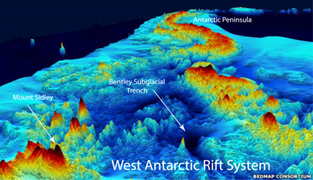
West Antarctic Rift System enhanced view. https://source.wustl.edu/2015/12/the-geography-of-antarcticas-underside/
West Antarctica Rift System Volcanoes
The following description is borrowed in large part from the 2017 De Vries et al paper. http://sp.lyellcollection.org/content/specpubgsl/early/2017/05/26/SP461.7.full.pdf
A survey published in 2017 by De Vries et al created an inventory of 138 volcanoes in WARS, 91 of which were previously unknown. These are widely distributed but concentrated and oriented along the 3,000 km central axis of the WARS. The survey used airborne radar to discover the hidden volcanoes. Ice thickness in the region was measured with a combination of aeromagnetic data, gravity, laser elevation, and radar measurement techniques on survey flights.
Activity along the WARS has been debated for over a decade with the two sides arguing active versus inactive rift. The argument in favor of an inactive rift is based on the “… anomalously low elevation of WARS compared to other active continental rifts” and the lack of basaltic pebbles recovered from boreholes. Arguments in supporting an active rift are the presence of at least 138 low, relatively young shield volcanoes, with their shields still intact. The uneroded nature of the cones argues active volcanic activity and in turn an active rift.

Newly discovered volcanoes along the West Antarctic Rift System http://www.scar.org/features/1115-antarctic-volcanoes-identified
Average height of the shields were 700 – 940 m. Average diameter 17 – 22 km. And average volume just under 150 km3.
The study was not able to determine if the volcanoes were currently active. This evidence comes from ice core records taken from the WAIS that suggests multiple subglacial Marie Byrd Land volcanoes were active in the Late Quaternary. Recent seismic activity in Marie Byrd Land has been interpreted as active volcanism. In the vicinity of the Pine Island Glacier, strong radar returns beneath the ice are interpreted as evidence of a local eruption some 2000 – 2400 years ago.

Subglacial volcanic centers. Blue dots are the newly discovered volcanoes in the rift system. Red dots are the volcanoes on the Marie Byrd Land rise. http://forum.arctic-sea-ice.net/index.php?topic=333.0
Several previous studies suggest the entirety of Marie Byrd Land is supported by a low-density mantle, possibly a volcanic hotspot. On the opposite rift end, Mount Erebus is a known active volcano which may be located above another volcanic hotspot.
The widely distributed volcanism is thought to contribute to higher geothermal heat fluxes that underlies much of the WAIS. This has led to investigation of melt water destabilizing the WAIS. This is balanced by the protrusion of multiple shield volcano cones into the underside of the WAIS which tend to stabilize the downhill movement.

Marie Byrd Land heat basement heat flux. http://advances.sciencemag.org/content/1/6/e1500093.full
One of the conclusions about the end of the last ice age is that the thinning of an ice cap / ice sheet above an active volcanic region unloads and decompresses the underlying magma, enhancing volcanic activity. The WAIS is thought to have compressed most portions of Marie Byrd Land by at least a kilometer. The De Vries paper suggests that the multiple shield volcanoes beneath the WAIS were a product of the last cycle of deglaciation in this part of Antarctica some 400,000 years ago.
There is a paper that ran a number of ice sheet stability models based on Milankovtich Cycles (changes in the eccentricity of Earth’s orbit which in turn drive insolation and in turn are thought by some to contribute to ice age cycles). If the simulations are correct, the WAIS has collapsed at least three times in the last million years – 200,000, 400,000 and 800,000 years ago. With each collapse, isostatic rebound due to the loss of the ice cover should have triggered significant volcanic activity, not unlike the caldera outbreak we have seen along the Alaska Peninsula following the end of the last ice age.

Map of Marie Byrd Land showing location of large shield volcanoes. http://www.largeigneousprovinces.org/13apr
18 Shield Volcanoes
The Marie Byrd Volcanic Province hosts 18 large (volumes on the order of 1,800 km3 apiece) alkaline basalt volcanoes occupying a 500 x 800 km block faulted dome within the West Antarctic Rift. The continental ice sheet buries 16 of them to progressively greater depths leaving only 5 sufficiently uncovered to study. In gross structure and composition, one of them, Mount Murphy is similar to the Gran Canaria volcano, though the percentage of felsic rock is triple that of Gran Canaria.
11 of the volcanoes are situated in three N – S and E – W linear chains. These chains suggest migration of volcanic activity along linear paths 90 – 154 km long. The problem is that the Antarctic Plate is relatively stationary and has not moved in late Cenozoic time. Linear movement is thought to be related to fracture propagation due to crustal doming which opens pathways for magmas to reach the surface.

Schematic of volcanoes in Marie Byrd Land volcanic province https://www.researchgate.net/figure/223157651_fig1_Fig-1-Regional-location-map-of-the-Marie-Byrd-Land-volcanic-province-of-West
A 2005 paper by Simian out of NZ detailed characteristics of the 18 shield volcanoes in Marie Byrd Land. http://www.anta.canterbury.ac.nz/documents/GCAS_7/Simion_L_Lit.Review.pdf
At least four of these volcanoes have been recently active. These include Mt. Berlin, Mt. Takahe, Mt. Siple, and Mt. Waesche.
Two of them are likely currently active, Mt. Berlin and Mt. Siple. A 1988 satellite photo taken on Oct. 4, 1988 showed a plume extending some 160 km to the NNW. No evidence of fresh ash, new craters, or snow cover changes were observed during an aerial inspection in late Dec. 1988.
Mount Berlin has 4 – 6 active fumaroles on the west side caldera rim. No eruptions have been directly observed from these volcanoes.
There are several Marie Byrd Land tephra sites located in the ice. These are associated with Mt. Waesche, Mt. Moulton, Mt. Berlin and Mt. Takahe which has seven layers.
The volcanoes themselves are primarily shield volcanoes, built on a succession of volcanic layers. The first layer on the basement is hyaloclastites, followed by lava flows, Strombolian bombs and cinders. Most of the volcanoes are well preserved and the rocks very fresh. Weathering rates of the ice sheet are slow, even during interglacials. There is data that indicates the entire ice sheet was lost around 400,000 years ago.

Mount Takahe poking thru cloud cover. Satellite photo. http://blog.imagico.de/spring-again/
Mt. Takahe is an isolated volcano some 3,460 m high, 2,100 m above the ice. The base is 35 km in diameter at the top of the ice sheet. The volcano is circular topped with a 8 km caldera. The base is composed of lava flows and hydroclastic deposits. The Hydroclastics include pillow lavas, pillow breccias, and hydroclastics. Takahe is one of the youngest volcanoes in the region, with much of it built over the last 400,000 years. There is evidence of subglacial eruptions around the base when the WAIS was as much as 300 m thicker than today. The subglacial tephras indicate Takahe erupted as recently as 30,000 years ago.

Ames and Flood Ranges including Moulton, Berlin, Merrem, Andrus, Hutt, Kosciusko and Kauffman. http://jgs.lyellcollection.org/content/167/2/401.figures-only
Mt. Berlin is the highest volcano in the western part of Marie Byrd Land. It consists of two volcanoes – Berlin and Merrem Peak, each topped with a 2 km diameter caldera. The base is completely surrounded by the WAIS, with 2,100 m of volcano above the ice on the north and 1,500 m on the south side. There are trachytic hyaloclastic tuffs that are older than either of the two peaks and may represent a subglacial eruption. The main period of edifice building is within the last 600,000 years. Lavas around both summits are less than 100,000 years old. Berlin is one of the youngest volcanoes in the region along with Takahe.
Mt. Moulton is also formed by a pair of volcanic cones, each topped with a 3 km diameter caldera. The calderas are 8 km apart and top out just short of 3,100 m. The entire volcano measures some 30 km above the ice. They age as some 4.7 – 4.9 Ma and are 20 km east of Mt. Berlin. Moulton is completely surrounded by the WAIS and stands 1,700 m above the top of the ice. Summit ice core tephra layers indicate an age of half a million years.

Toney Mountain and Mount Waesche photos showing volcano elongation and flank vents. http://jgs.lyellcollection.org/content/167/2/401.figures-only
Toney Mountain measures 50 km long. It dates less than a million years old on the upper portion of its cone.

Executive Committee Range showing relative ages of volcanoes. Open circles are cinder cones. http://jgs.lyellcollection.org/content/167/2/401.figures-only
Mt. Waesche is in the Executive Committee Range. It is also a pair of close volcanic peaks, Chang Peak and Mt. Waesche. It tops out some 1,200 m and 700 m above the top of the ice sheet. Chang Peak lavas date as far back as 1.6 Ma. Waesche dates as far back as 1 Ma. There are lavas younger than 100,000 years on the upper slopes. Based on ash layers in ice cores found at the Byrd Stations, the volcano may have been active in the past 30,000 years ago. It is located 25 km SW of Mt. Sidley, the highest volcano in Antarctica.
Mount Sidley is 4,181 m above sea level and 2,200 m above the ice. The main caldera is 5 km in diameter. The summit peak stands 1,200 m above the caldera floor. The major part of the volcano was built some 4.7 Ma. It suffered a flank collapse / lateral blast eruption that blew out most of the south side of the caldera, with extensive hydrovolcanic deposits from the subglacial eruption extending outward several miles.

Photos of Marie Byrd Land volcanic province members http://bulletin.geoscienceworld.org/content/118/7-8/991
Mount Siple is a volcano that sits on the coast. It is comparable in size to Mt. Erebus, with an estimated volume of 1,800 km3. It is not concealed by the WAIS and rises to 3,110 m above the water. It is topped with a 5 km diameter caldera. There was a satellite photo taken on Oct. 4, 1988 showing what looked like a volcanic plume extending over 160 km to the NNE. Inspection that December found no evidence of an eruption.

Mount Siple from the ocean showing fumarole activity. http://www.skimountaineer.com/ROF/ROF.php?name=Siple
Mt. Hampton is another close pair of volcanoes – Hampton and Whitney Peak. It is almost completely covered by ice with only 900 m above it. The two volcanoes are topped by 5 km calderas. It is one of the oldest volcanoes in the range at 11.4 Ma. There are snow and ice towers on the caldera rim indicating recent fumarole activity.
Mt. Cumming is an isolated single caldera to the south of Mt. Hampton. It only has 400 m of its summit above the ice.

Cray Mountains showing elongation and cinder cones (open circles). http://jgs.lyellcollection.org/content/167/2/401.figures-only
The Crary Mountains are an isolated group of major volcanoes. The two volcanoes are Frakes and Stere. They share a massif some 60 km long. Frakes is the highest. Both are topped with 2.5 km calderas. Just north of Mt. Stere is a deep subglacial basin with a floor 1,900 m below sea level. It is filled with 3,400 m of ice. Frakes dates at 4 Ma and built on the SE flank of Steere (8 Ma).
Mt. Murphy is one of the most eroded volcanoes in the region. The WAIS tends to protect the bases of volcanoes inland. It is too thin next to the coast to do the same. Murphy dates to 8 Ma.
Mount Andrus is the youngest of a triple grouping of volcanoes in the Ames Range of Marie Byrd Land. It is topped with a 4.5 km caldera and is the youngest of the grouping. Weak fumaroles are observed on Mt. Kaufman, the northernmost volcano, which also sports a 3 km caldera. Andrus is nearly 3,000 m tall.

Schematic of new Executive Range volcano https://www.pinterest.com/pin/540643130239924034/
Eruptions
There is a 19th volcano that appears to be under construction in the Executive Committee Range. This was one of the triggers for articles of subsurface volcanic action a few years ago. Two earthquake swarms were measured by a research team in the area in Jan 2010 and Mar 2011. The swarms were 25 – 40 km deep. There are no signs of a surface eruption, though there is a 1,000 m bulge in the ice. The activity is centered some 50 km away from Mt. Sidley, the youngest volcano in the Executive Committee Range.
There is an 8,000 year old ash layer above the newfound volcano, but is currently thought to have come from Mt. Waesche.
The migration of volcanic activity along the current line is southbound about 10 km / Ma. The line of migration is perpendicular to the very slow motion of the Antarctic Plate, so plate motion / hotspot action should not be the cause.

Relative velocity of ice flow from the Antarctic ice sheets. Pine Island glacier is depicted in the red box on the left. http://www.antarcticglaciers.org/glaciers-and-climate/shrinking-ice-shelves/pine-island-glacier/
The eruption below the ice sheet triggered no small amount of speculation on the impact of large amounts of melted water on the bottom of the WAIS. Most speculation centered on feared destabilization of the ice sheet. The sheer volume of speculation tended to drown out the actual science involved in identifying both the volcano and its eruption.
This speculation was heightened with the discovery of another recent volcanic eruption in the Hudson Mountains around 207 BC, some 2000 years ago. The eruption was a VEI 3- 4 in size and appears to have accelerated the flow of the Pine Island Glacier, an active ice stream glacier responsible for nearly a quarter of total ice flow off Antarctica. The Hudson Mountains are slightly eroded parasitic cinder cones forming nunataks protruding slightly above the ice. There was possible steam observed from one of the cones in 1975. Satellite data indicates there was another eruption in 1985, though this one was not confirmed.
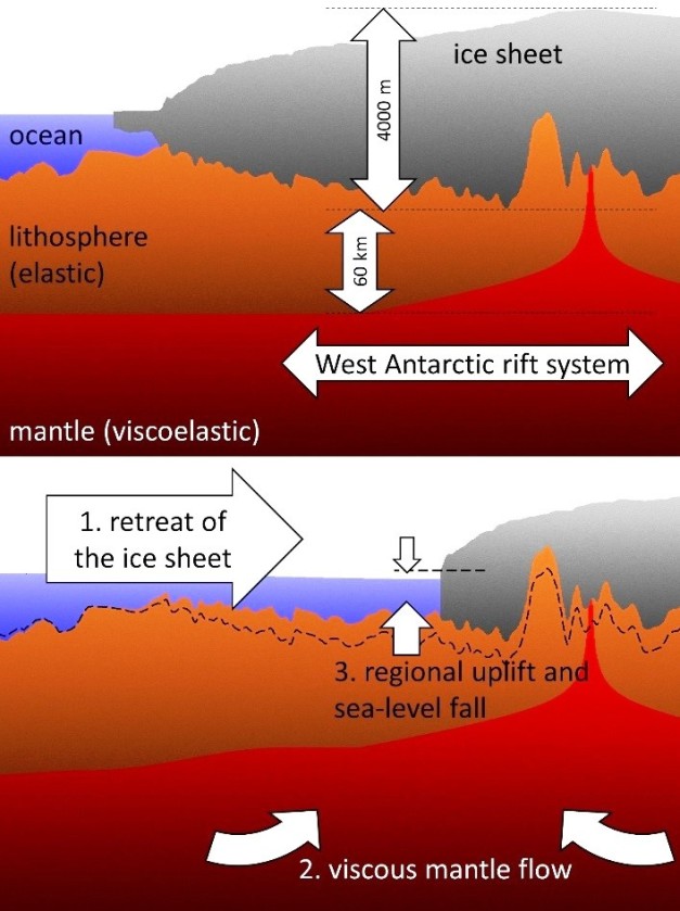
Isostatic rebound under the West Antarctic Rift System (WARS) following collapse of the ice sheet. http://cpom.org.uk/earth-and-ice-may-share-a-closely-entangled-evolution-in-west-antarctica-over-the-millennia-how-does-this-add-to-possible-collapse/
Tectonics
The big tectonic feature in Marie Byrd Land is the Western Antarctic Rift System (WARS). This is primarily an extension feature without significant uplift like the neighboring Transantarctic Mountains (TAM). It is covered by the West Antarctic Ice Sheet (WAIS). It is located at the plate boundary between East and West Antarctica, a classic weak point in the larger plate. Significant portions of the WARS basin lie well below sea level, and so does the base of the overlying WAIS. Four interior ice filled troughs in it extend as much as 2,500 m below sea level. The system is some 3,200 km long and 600 – 800 km wide.
The rift was created by intra-plate extension since 34 – 30 Ma, though it may date back as far as 43 Ma. This interpretation also implies that the Antarctic Peninsula has been a part of a stable East Antarctic Plate since that time. Additional rift basins exist on either end of the WARS, and elevated heat flow from the rift likely influenced ice sheet development and stability.

Schematic cross section of West Antarctic Ice Sheet from Bellingshausen Sea to the Ross Ice Shelf. Note that most of Marie Byrd Land is below sea level. http://www.antarcticglaciers.org/glaciers-and-climate/ice-ocean-interactions/marine-ice-sheets/
Bentley Subglacial Trench recent extension may explain higher than expected heat flow. Concern that higher than normal heat flow / recently active subglacial volcanoes will destabilize the ice cap / ice shelf. But don’t know conditions at the bottom of the ice pack.
West Antarctic Rift System (WARS) – similar to Rio Grande Rift, no longer active. Stopped recently. Has not had time to cool completely. Started rifting around 100 Ma.
WARS is an extensive region of stretched continental crust comparable with the East African Rift System and the western US Basin and Range Province.
A Mantle Plumes article from October 2006 makes the case that there are no hot spot tracks, no time progression of volcanic activity in the WARS. And there is no definitive proof in support of or against plume occurrence in the rift system.

Schematic of West Antarctic Rift System and Marie Byrd Land rise. http://geology.geoscienceworld.org/content/36/3/247
There is doming uplift in Marie Byrd Land. There is no doming uplift on the western coast of the Ross Sea. Uplift there is linear, connected to the formation of the Transantarctic Mountains cut by transverse fault systems in northern Victoria Land.
There has been prolonged subsidence and basin formation since the Cretaceous. The main extensional episode took place in the late Cretaceous while the main uplift event started in the middle Eocene, which was the same time magmatism started.
Aerial surveys suggest a large amount of volcanic products were produced beneath the ice sheet, perhaps as much as a million km3. Igneous activity appears to be governed by plate dynamics rather than driven by mantle plume or hot spot action from below.
There is a mantle blob (low velocity zone?) some 60 km below Mount Sidley. Heat flow thru crust has only been measured in 12 places in Antarctica (as of 2015), compared with 34,000 locations elsewhere. There is a lot of unexplored Antarctica left to take a look at.

Mount Sidley showing amphitheater from flank collapse / lateral blast. http://www.businessinsider.com/mount-sidley-antarctica-satellite-2015-2
Conclusions
Marie Byrd Land is indeed a land of fire and ice, with a robust number of relatively recent active volcanoes. While the magmas tend to be similar to what is seen from mid-ocean island volcanoes, they interact directly with kilometers of ice above them, creating ashy eruptions, subglacial shield volcanoes, and massive volcanic structures.
This is one of the most remote and inhospitable places on the planet, limiting scientific study of the volcanoes and their activity. The region is not well instrumented, and much of the sensing comes via expeditions mounted mostly during the local summer.
But the creation and growth of volcanoes below, though, and above the ice sheet has been prolific and apparently rather recent. Ice coverage has varied through the millennia, with most of the region being ice free one to three periods in the last million years. There is no reason the ice sheet cannot collapse again under the right interglacial conditions.
With all that being said, it hosts volcanoes, a number of active, ashy, violent volcanoes. It hosts a volcano with an amphitheater indicating a flank collapse. And most of the large volcanoes above the ice on the rise host calderas. We do not yet know whether or not these calderas were formed by violent eruptions of subsidence. But given the prevalence of ice and the availability of magmas, I would not discount explosive events.

Update 10/08
Tried to clear up confusion between stratovolcanoes and shield volcanoes in the province, mostly in the 18 Shield Volcanoes section and in captions. Thanks to Granyia for pointing this out.
Additional Information
https://www.sciencedaily.com/releases/2015/12/151208134632.htm
http://sp.lyellcollection.org/content/specpubgsl/early/2017/05/26/SP461.7.full.pdf
http://adsabs.harvard.edu/abs/2013BVol…75..726L
http://onlinelibrary.wiley.com/doi/10.1029/JB094iB06p07223/full
http://onlinelibrary.wiley.com/doi/10.1029/2009GL040721/full
http://www.mantleplumes.org/Antarctica.html
http://citeseerx.ist.psu.edu/viewdoc/download?doi=10.1.1.721.9914&rep=rep1&type=pdf
http://www.geol.ucsb.edu/faculty/luyendyk/mycontent.html
http://www.geol.ucsb.edu/faculty/luyendyk/Luyendyk_pdf/LuyendyketalMBLSOAR03.pdf
http://www.businessinsider.com/mount-sidley-antarctica-satellite-2015-2
https://link.springer.com/article/10.1007/BF00326462
http://www.anta.canterbury.ac.nz/documents/GCAS_7/Simion_L_Lit.Review.pdf
http://jgs.geoscienceworld.org/content/167/2/401
https://s3.amazonaws.com/Antarctica/AJUS/AJUSvXVIn5/AJUSvXVIn5p19.pdf


James Reynolds (EarthUncutTV) just posted his first footage of Shinmoedake eruption:
LikeLike
New research has been published on “…the Columbia River Flood Basalts (CRFB), whose sulfur output was 4,000 times that of Tambora. This is the equivalent of one Tambora paroxysm every day for 11 to 16 years, according to the researchers”. This is from an IFLscience article, or read the Geology Paper (DOI: 10.1130/G39371.1 – “coming soon”)
LikeLike
Agung becoming somewhat agitated… look at the seismogram! (upper right corner)
LikeLike
It might have been the rain again, little steam explosions all night. Which is probably not good, opening up more cracks for water to get deeper, thus preparing for a phreatic outburst.
And now there are minutes of tremor speaking of rising magma… Wonder if one can tell “harmonic” from “non-harmonic” tremors on this seismogram? I guess one has to look at the spectrograms to know?
LikeLike
I still can’t see any tremor there. There are a couple of fuzzy patches that look like they might be, but after checking them against JAGI I think they are just teleseisms.
LikeLike
New post is up 🙂
LikeLike
Pingback: Works cited – Save Marie Byrd Land!
Pingback: Antarctica is rising in response to change that started with end of last ice age | Watts Up With That?
Pingback: Antarctica is rising in response to change that started with end of last ice age |
Pingback: Antarctica rises in response to modifications that started with the top of the final ice age | Tech News
Pingback: Could Rising Land Slow Down West Antarctic Ice Melt? - The Global Warming Policy Forum (GWPF)The Global Warming Policy Forum (GWPF)
Pingback: Science at the South Pole: Fire and Ice – Never Trust An Atom