

Lunar Crater Volcanic Field from the air. Lunar Crater itself is a maar. Photo courtesy Hindred Settling Blog. https://zsylvester.blogspot.com/2009/12/lunar-crater-volcanic-field-nevada.html
Note: This post is one of those that started out small and kept on growing. Part 2 including the tectonics workup will be posted shortly.
There are at least 10 known small volcanic fields in the state of Nevada. These are generally basaltic magma powered features, though there is one field with small rhyolitic domes and another with a pair of maars.
Nevada is tectonically part of the Basin and Range province of the western and southwestern US. In Nevada, this is generally an east – west stretching and thinning of the continental crust allowing decompression melt to reach the surface through various faults.

Map of caldera outbreak in Nevada. Image courtesy Carleton University. https://earthsci.carleton.ca/news/15/professor-cousens-completes-field-work-nevada
The central portion of Nevada was also part of the massive ignimbrite outbreak in Nevada – Utah – Colorado 38 – 18 Ma which left that portion of the state littered with calderas and their products. https://volcanohotspot.wordpress.com/2016/10/18/the-utah-nevada-ignimbrite-flareup-of-30-ma/
The northern part of the state shares part of the initial track of the Yellowstone hot spot after it triggered the formation of the Columbia River Basalt Group and moved NE over the course of the last 17 Ma. There are multiple calderas along that track not associated with the older ignimbrite outbreak.
There are a number of monogenetic volcano fields to the west of Nevada in California. These are typically near the western border of the Basin – Range Province. From north to south, these include Tahoe – Truckee, Inyo Craters, just to the south of Aurora – Bodie, Big Pine, Ubehebe, Cima, Pisgah and Amboy.

Map of volcanic fields in Nevada and in neighboring California to the west. Note border of Basin and Range Province at the base of the Sierra Nevada mountains. Both Buffalo and Lunar Crater fields are depicted north of their actual locations. Image courtesy Valentine, et all. https://pubs.geoscienceworld.org/gsa/geosphere/article/13/2/391/208031/lunar-crater-volcanic-field-reveille-and-pancake
Nevada is primarily arid to semi-arid. While tourism is the largest employer, mining is a substantial part of the economy, with Nevada being the fourth largest producer of gold in the world. Cattle ranching is also a large part of the economy. There is significant military presence with Nellis AB and the ranges to the north of Las Vegas. These ranges include the fabled Area 51 and the Nevada Test Site where the US did most of its underground nuclear testing.
Gambling and relatively lenient divorce and marriage laws also draw no small number of tourists. It is also the only state in the union where prostitution is legal.

Fly Geyser, NV showing newly deposited travertine. Image courtesy Matador Network https://matadornetwork.com/read/visit-fly-geyser-nevada/
There is a manmade geyser called the Fly Geyser. It is located in western Nevada midway between Reno and the northern border. A rancher was drilling for irrigation water a century ago. He hit a well and tapped geothermal boiling water (100 C). This water built a 3 – 4 m tall calcium carbonate cone.
In 1964 a geothermal energy company drilled a test well at the same site. This one did not find hot enough water to use for energy production and the well was capped. But it wasn’t capped all that well and created a new geyser, drying the first one. This one has multiple spouts, and dissolved minerals and algae has created a travertine mound.
The geysers are located on private land and not yet open to the public, though that effort is underway.

Map of Sheldon National Wildlife Refuge. Volcanic field is mostly contained within these boundaries. Image courtesy Sangres.com. http://www.sangres.com/nevada/wildlife-refuges/sheldon.htm
Sheldon – Antelope National Wildlife Refuge
There are several lava flows from small shield volcanoes in this part of the far NW corner of Nevada. The flows are 20 – 35 km long and straddle the Nevada – Oregon border. They are poorly dated at 1.2 Ma. The volcanoes are situated in the former High Rock Caldera.
The calderas are referred to as the High Rock Caldera Complex, active for a million years starting 16.6 Ma. Eruptive products were generally rhyolites. Volumes for each eruption (some calderas had multiple eruptions) were greater than the 50 km3 DRE range, though estimating actual volumes is impossible due to the complexity of the activity. One of the calderas erupted around 220 km3 of rhyolite lavas, significantly greater than the ignimbrites from caldera formation.

General location of Columbia River Basalt Group, track of Yellowstone hotspot, and High Rock Caldera Complex between the two of them. Image courtesy Coble, et all. https://pubs.geoscienceworld.org/gsa/geosphere/article/12/1/58/132304/geology-of-the-high-rock-caldera-complex-northwest
These calderas appear to be related to early activity and movement of the Yellowstone hot spot and the Columbia River Basalt Group. One paper suggests that young, fresh, hot basalt from the Columbia River activity was injected into relatively inactive, evolved magma chambers, mobilizing and destabilizing them, triggering the eruptions. In this case, the basalts triggered massive rhyolite eruptions rather than flood basalts.

Dirt road through Little Sheldon, part of the original Antelope Refuge. Lava flow to the right of the road in the foreground. Photo courtesy Ward’s May 2007 trip NW NV page. http://www.wardjd.com/SheldonRefuge0705/index.htm
The area is most recently famous for an earthquake swarm 2014 – 2016 with over 5,600 earthquakes starting July 2014. More than 200 of the quakes were M 3 or greater with the largest at M 4.7. There is so far no volcanic activity associated with the swarm.
The region is remote from other young volcanic activity in Nevada. It is part of a National Wildlife Refuge. The refuge was created in 1931 and is home to wild horses, mule deer, pronghorn antelope, and a small population of bighorn sheep. It is called a sagebrush steppe and has enough water to support desert fishes (a mutually exclusive term?).

Schematic of possible basalt feed into High Rock Caldera Complex underlying Sheldon – Antelope Valley volcanic field. Image courtesy Coble, et all. https://pubs.geoscienceworld.org/gsa/geosphere/article/12/1/58/132304/geology-of-the-high-rock-caldera-complex-northwest
Volcanic rocks in the region range from andesites to rhyolites to basalt lava flows. The andesites are the oldest, laid down in the Miocene. They were followed by rhyolite tuff sheets from the caldera activity some 16 Ma. Basalt flows from recent activity cap much of the region and are variable in age.
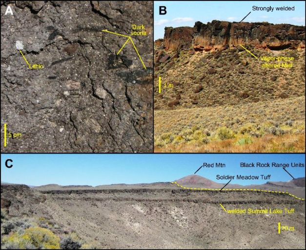
Photographs of Summit Lake Tuff outcrops. Image courtesy Coble et all. https://pubs.geoscienceworld.org/gsa/geosphere/article/12/1/58/132304/geology-of-the-high-rock-caldera-complex-northwest
There are active hot springs and adjacent cold springs. The area may have potential for geothermal power generation. It is sparsely settled.

Long-departed steam geysers at Steamboat Springs, NV. Geothermal drilling into the terrace destroyed natural geyser and hot spring activity. This photo is perhaps 40 years old of commercial drilling output. Image courtesy Elko Daily Free Press. http://elkodaily.com/lifestyles/beowawe-s-extinct-geyser-field/article_a494783c-8619-11df-a0b7-001cc4c03286.html
Steamboat Springs Lava Domes
Steamboat Springs are located 20 km SSE Reno. It dates 2.5 – 1.1 Ma and consists of rhyolitic lava domes and flows. There are no recent eruptions, but it is hydrothermally active. There are over 50 hot springs, steam vents and fumaroles. These include geysers and mud pots. The field is generally oriented N – S like most the rest of the fields in the state. It is an actively producing geothermal field.
The largest dome measures 150 m by 1 km in diameter. Two domes date 1.2 – 1.1 Ma, though obsidian dating of one of them is 3 Ma. The discrepancy is unresolved.
There is a 3 km long basaltic – andesitic unit SW of the domes that dates 2.5 Ma.

Geyser #42 West Steamboat Springs, NV. Circa 1987. Image courtesy Grover Schrayer, Flickr. https://www.flickr.com/photos/14833125@N02/3244060060
There was an apparently unrelated earthquake swarm 25 km NE Steamboat Springs in May 2008.
Steamboat Springs hydrothermal activity is thought to precede dome emplacement. It has also created deposits of gold, silver, mercury, antimony and arsenic. Hydrothermal systems that create gold and silver deposits typically last 1 – 2 Ma. The residual volcanic heat source is powering the extensive hydrothermal system. The magma chamber powering the activity is estimated at 90 km3.
The larger area around Reno, south to Carson City and east to Fallon is referred to as the Western Nevada volcanic field. It includes the Steamboat Springs basaltic andesites and rhyolite domes, McClellan Peak basalt flows around Carson City, Virginia City, Chalk Hills, Rattlesnake Hills, the Soda Lake Maars, Upsal Hogback near Soda Lake and the Buffalo Valley volcanic field. I describe Soda Lakes and Buffalo Valley later in this post.

Mount Scott – McClellan Peak Plateau. Image courtesy Summit Post blog. https://www.summitpost.org/mount-scott-mcclellan-peak-plateau-nv/493778
McClellan Peak Basalt has two geographic groups of volcanic structures. Those to the north are basaltic only. Those to the south also include basaltic andesite output. They are 1.2 – 1.4 Ma and include lavas and two cinder cones.
Rattlesnake Hill is located near Fallon. It is an eroded 1.2 km diameter cinder cone dating 1.03 – 1.20 Ma. Output is basaltic trachyandesite.
Steamboat Springs. Image courtesy Smithsonian GVP. https://volcano.si.edu/volcano.cfm?vn=326801
Gold, silver, other metal deposits, and sulphur provided the target for an active mining district in the region when it was settled. The largest commercial attraction were the hot water pools which attracted a hotel and bath house in 1859. At one point, there were over 20 active geysers, one of them the third largest in the US at the time.
There are still active local businesses with hot springs, healing waters and therapeutic muds.

Lathrop Wells Cinder Cone. Photo courtesy Las Vegas Review Journal. https://www.reviewjournal.com/news/science-and-technology/scientists-prepare-to-debate-danger-of-yucca-mountains-volcanic-neighbors/
Buffalo Valley
Buffalo Valley volcanic field has 14 vents and associated flows. It is just north of the Fish Creek Mountains caldera dated 24 Ma. The field is 5 x 15 km generally oriented north – south. The vents are generally topped by breached cinder cones in pairs or triplets.
Cones are generally 50 – 100 m tall and 150 – 500 m in diameter. Combined area of the lava flows is around 10 km2. Most of the cones and flows are dated more recently than 2.6 Ma. There has been little erosion in the field during the past 3 – 1.4 Ma. The cones date 1.4 – 0.95 Ma. The oldest dates 3.3 Ma. Lavas are basalts to trachybasalts.
Located 230 km SSE of Lunar Crater volcanic field. Basaltic scoria cones with lava fields. Two episodes of activity. 4.02 – 2.75 Ma erupted magmas from a relatively shallow asthenospheric depth. Most recent episode 1.99 – 0.07 Ma. Melting appeared to move deeper over time. Volcanoes appear to be collocated with faults that bound the Fish Creek Mountains.

Little Soda Lakes Maar. Photo courtesy Smithsonian GVP. https://volcano.si.edu/volcano.cfm?vn=326010
Soda Lakes Maars
Soda Lakes are a pair of basaltic maars formed after the draining of post-glacial Lake Lahontan. They are estimated to be 10,000 – 1,500 years old.
The larger maar, Soda Lake is 1.3 x 2 km in diameter, with the long axis generally NE – SW. The smaller maar, Little Soda Lake, is 300 m in diameter and lies south of the larger maar.

Airborne photo of Soda Lake Maars. Image courtesy http://plate-tectonic.narod.ru/volcanoam4photoalbum.html
There scoria cones called Upsal Hogback to the NNE of Soda Lakes. It includes a group of low-lying maars, tuff rings and surge deposits. Tephra layer in nearby Lake Lahontan dates this around 25,000 years old.

1869 photo of Sodaworks at Soda Lake Maar. This is now under 4 -5 m of water. Photo courtesy Forgotten Nevada. http://www.forgottennevada.org/sites/sodalake.html
The site was a geothermal prospect that may have had active hot springs as recently as the end of the 19th Century.
The area was settled in the early 1850s. Early miners dug up layers of crystalline sodium carbonate (soda) just below the surface of the water. Soda was mined at Soda Lake starting in the late 1860s and a “Soda Works” operated for decades mining, evaporating, and selling washing soda from Soda Lake. Irrigation projects brought water into the valley for agriculture, eventually raising the local water table covering the mining operation with over 10 m of water. The lake is 15 m deeper than in the mid-19th Century.
There are hot and cold springs in the area, with one hot spring providing over 16 MW of geothermal power.
=====================================================================
Part 2 next: Aurora – Bodie Hills volcanic field, Lunar Crater, Timber Mountain, tectonics and conclusions.
Mud Springs volcano upper right, Aurora – Bodie volcanic field. Lava flow is andesitic. Photo courtesy NASA Earth Observatory. https://earthobservatory.nasa.gov/IOTD/view.php?id=50493
Additional Information
https://www.volcanodiscovery.com/nevada.html
http://www.nbmg.unr.edu/scienceeducation/earthcaches/BlackRockLavaFlow.html
https://pubs.usgs.gov/sir/2016/5089/b/sir20165089b.pdf
http://www.wardjd.com/SheldonRefuge0705/index.htm
https://pubs.geoscienceworld.org/geosphere/article-lookup/13/2/391
https://pubs.usgs.gov/sim/3318/downloads/SIM3318_Pamphlet.pdf
https://earthobservatory.nasa.gov/IOTD/view.php?id=50493
https://pubs.geoscienceworld.org/geosphere/article-lookup/8/1/44
https://pubs.usgs.gov/pp/0458d/report.pdf
http://www.nbmg.unr.edu/scienceeducation/earthcaches/cinderconeclaytonvalley.html


Seismogram of Galeras volcano during the last hour – strongest events in the M 4+ range (latest eq here: https://saemodal.sgc.gov.co/web/dist/index.html?vm=v :
(src: http://amenazas.sgc.gov.co/helicorders/pasto/heli.angv/sismograma_digital_anganoy.gif)
LikeLike
Can you tell me where where a re basalt volcano with a chat road running through it is located? It will be on a side road that dead ends, and the through road, which this road stems from, has 3 natural arches that you drive through. I thinks its in Nevada but it maybe Utah instead. I can’t seem to remember the path i took. Thanks. please email romankorvinus@yahoo.com
LikeLike
Howdy Roman – my best guess based on your description I think you were on the Markagunt Plateau, which is a relatively big deal as it is the site for one of the largest landslides known on the planet, though a bit old. Here’s where I think you were:
There are at least 2 short tunnels carved thru sandstone along Utah Scenic Route 12. They look a lot like arches. The scenic route starts near Panguitch on the west and proceeds east. I am guessing he was passing thru relatively recent volcanic activity in Bryce Canyon National Park / Markagunt Plateau, Utah.
https://www.brycecanyoncountry.com/volcanic-lava-activity-bryce-canyon-country/
https://www.visitutah.com/articles/the-all-american-road-scenic-byway-12/
This is all within driving distance of spending the night in Tuba City. Cheers –
LikeLike