
The spectacular caldera of Nemrut Dağı: light snow cover enhances all the volcanic features inside. (NASA image ISS001-E-6354 taken on 2001.02.13)
Preliminary note:
I have started work on this post long before the latest unacceptable political developments, so, it is pure coincidence that it’s getting published just now. In the region around Nemrut Dağı live Kurdish, Turkish and Armenian people. I wish peace for them all – and hopefully, my post will inspire interest in this wonderful part of the world.
~~~
Nemrut Dağı* volcano has so many interesting features within and outside its caldera that it would probably take a several-week-long holiday do visit and explore them all. It has produced many colourful layers in ignimbrites during its various, mainly Plinian eruptions, as well as lava domes and obsidian flows, open fissures, steam chimneys, lava caves, what have you. I think this will become my favourite volcano!
*It should not be confused with the famous UNESCO World Heritage site of the same name, some 350 km to the E: Mt. Nemrut, near Adıyaman, with its ancient tomb-sanctuary and huge carved rock statues.
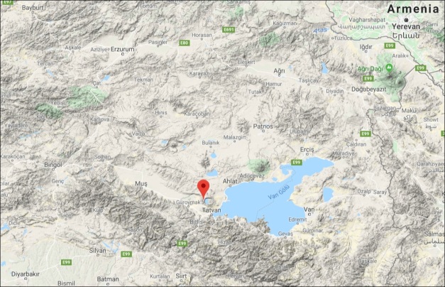
Nemrut volcano is located between the Tatvan, Ahlat and Güroymak districts of the Bitlis province, near the south-western shore of the large Lake Van, on the high plateaus of Eastern Anatolia in Turkey. Many say the name Nemrut refers to the biblical King Nimrod who is believed to have been a great-grandson of Noah. More probably, though, it is the Armenian word nemrout, meaning gloomy or angry, which seems befitting for a volcano.
THEY SAW HOW A WIDE CRACK SPLIT THE MOUNTAIN…
The geological history of the volcano has only been explored in very recent times. In the 20th c. the scientific investigation of the volcano was halted by the unfavourable political situation. During most of that century Nemrut was even wrongly classified as an extinct volcano. Only in the 1980s, with the resumption of the studies by Turkish volcanologists, its status was changed to dormant. The volcano is still not quite understood, and there is no general consensus on the interpretation of stratigraphic data.
Eruptions of Nemrut are mentioned in Armenian sources of the 15th century and Kurdish sources of the 16th century. These records have helped to confirm that the volcano has been active during the Holocene, and to establish the dates of some eruptions:
“In the year of 1441, Nemrout Mount between the towns of Khlat [Ahlat] and Baghesh [Bitlis] thundered suddenly as a terrific thunder-storm; the entire country shuddered since they saw how a wide crack split the mountain and misty smoke and fetid flame were coming out of the crack. Children fell sick of that smell, and stones boiled of the burning flame, huge stones five kangoun in weight were thrown into sky; the fire was seen from the two-day travel distance. The town of Khlat was trembling from that thunder. The mountain split and opened a huge abyss, and stones on the summit boiled and melted, and glued each other, and so this continued for years…”

A seasonal hot spring lake in Nemrut caldera, with a lava dome behind it to the left. (© EvgenyGenkin, via Wikipedia)
Another report (Serefhan 1597) gives a later eyewitness description of an eruption of the Nemrut volcano. But the latest record found so far is from either 1650 or 1692. This describes a situation in Bitlis [Baghesh in Armenian], 25 km south of the volcano, but is not so far scientifically confirmed as an eruption of Nemrut volcano. Sumita & Schmincke (2013) speak of “late Holocene(?) rhyolitic phreatomagmatic deposits” which were emplaced at the caldera margin. Perhaps this could have been one of those explosions?:
“In the town of Baghesh [Bitlis], on April 13, summer 1692, sunlight dimmed ever since the morning and colored plumbeous; darkness shrouded the earth so that people could not see each other. Till the very evening, red dust had fallen to the ground and there was an earthquake, many settlements were ruined and many people died.”
Who knows, when more research is done in historical libraries, maybe some even more recent eruptions will come to light?
NEXT WITNESS: THE VAN LAKE BOTTOM!
Lake Van is an ‘endorheic” lake. i.e. it has rivers and streems going in, but, no outlet has been found. The origin of Lake Van had often been speculated upon. During his travels in 1893, the British explorer Captain F. R. Maunsell pondered about the lake and reached this conclusion: “It seems not unlikely that a lava overflow from the volcano Mount Nimrud, on the western shore of the lake, cut off the plain of Van from the Tigris, and thus formed the lake.” Turns out he was right with that.
It is now generally thought that, during the constructional phase of Nemrut Dağı, indeed an extrusion of lava or other pyroclastic deposits dammed the ancient Murat Valley (to the west), where once the Zilan and Bendimahi Rivers flowed from Lake Van to join the Murat, a tributary of the Euphrates. These two rivers are still going into the lake on the northern and eastern side. Yet this eruptive event had cut off the outflow, and so marked the beginning of modern Lake Van. Degens et al. (1984) calculated the time it would take to fill a lake of this size after the river has been blocked, the result: only about 500 years appeared to be necessary for the lake to acquire its current shape and level.

Impact of volcanic activity on the hydrographic network and main watersheds (western part of Van Lake) (Ulusoy et al., 2019)
They also took core samples of the lake sediment. The most distinctive feature of these was the fine lamination of volcanic and other lacustrine materials. The volcanic ash and glasses were dacitic to trachytic in nature, suggesting that the volcanic layers were derived from acid (rich in silica) volcanism. Comparing them to the chemistry of other volcanoes in the area, they concluded that the ash layers in lake Van sediments are exclusively derived from Nemrut Volcano. The fine layers in sediment are called warves. This explains why, in the GVP database, the source of eruption history data for Nemrut is noted as “warve count”.
Video of divers exploring the bottom of lake Van: there are not only submerged buildings but also what looks like volcanic structures. The press call them “fairy chimneys”. If they are indeed some type of chimneys (and not, say, encrusted tree trunks), they should be degassing pipes from some hot deposits cooling fast in the water. (Video by TRT Haber newspaper)

Discovered on Van Lake bottom: they call it fairy chimneys, but I suppose they may be degassing pipes from hot materials that have cooled fast in the lake water.(© no photographer given; via Onedio news)
A HODGE-PODGE OF FAULTS AND BLOCKS
The general tectonic structure of the East Anatolia Region is mainly controlled by the collision of the Eurasian, African and Arabian plates. The Arabian plate is moving in a NNE direction, with respect to Eurasia at a rate of about 15 mm/year. This results in continental collision along the Bitlis Suture Zone (BSZ) which is the southern boundary of this region. Agimarc has covered the general tectonics of Turkey more detailed in his post about Ararat HERE.
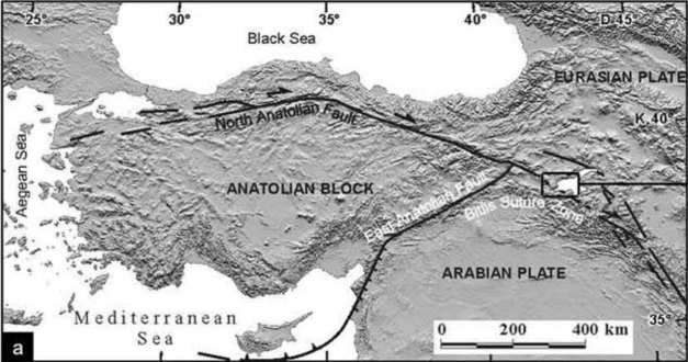
Anatolian, Eurasian, and Arabian plates with Lake Van north of the collision zone (Bitlis Suture Zone or Bitlis-Zagros Fault Belt). The rectangle marks the area around Lake Van. ( Aydar et. al., 2003)
Among the main players in this complex setting are two great faults: the North Anatolian Fault and the East Anatolian Fault. They meet at the Karlıova Triple Junction, encompassing the Anatolian Block between the Black Sea and the Mediterranean Sea. While the Arabian plate collides with the Eurasian in N-S direction, the Anatolian Block is rotating counter-clockwise and “escapes” from between the two in SW direction – leaving behind a lozenge of very thin stretched oceanic lithosphere, remnants of the crust that was once below the former Tethys ocean. Volcanism here may be the result of the thinning of the crust where it had been squeezed and thickened before.
On the other hand, the former Tethys oceanic crust was once subducted by the Arabian plate. After the ocean had closed, subduction stopped and the Arabian Plate crushed head on to the Eurasian. Researchers think that the previously subducted slab was steepened down and eventually broke of. This remnant piece could still promote voluminous magma generation.
So, volcanism in Eastern Anatolia began as a result of the various compressional and extensional stresses in the crust. These have triggered the formation of stratovolcanoes Nemrut Dağı, Süphan and Ağrı (Ararat), the shield volcano Tendürek, and the fissure-type volcanism of which there are many examples in eastern Anatolia. Nemrut volcano grew in the hinge zone between two tectonic pull-apart basins: the east–west-oriented Van Basin to the E and the extremely flat-floored Muş Basin extending for ca. 50 km WSW of Nemrut.
THE VOLCANO
Nemrut is the westernmost of a row of several volcanoes along a complex fault system. It’s activity has been initiated by N–S extension of the crust in this area. It also sits across a N-S running fault zone. The volcano covers an area of ~36 km2, less than 10 km north of the town of Tatvan, near the southwestern tip of Lake Van (1648 m a.s.l.).
If you “drive” around between Lake Van and Nemrut on G StreetView you see evidence of the volcano’s activity everywhere – there are domes and flow deposits, many rugged hill sides, eroded chimneys, road cuts that show the tephra layers etc. Even the main road crosses several times over flow deposits that once have run into lake Van – or the valley that was there before the lake.
Nemrut Dağı has a well-developed, impressive caldera. It contains a large caldera lake with 15 km² surface area. This is the largest in Turkey, the fourth largest in Europe and sixteenth largest in the world (haven’t fact-checked these claims, though). The caldera contains nearly two dozen cinder cones and lava domes, rhyolithic lava flows and no less than 10 maars.

The main volcanogenic features within the caldera and at the northern fissure zone. (Ulusoy et al., 2019)
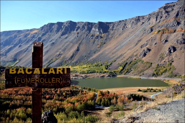
The main Nemrut crater lake (fresh water) is not warm, though it does not freeze in winter. Another crater lake, the smaller lake Ilıgöl, gets hot enough with sometimes up to 60°C in places, but it does freeze because of its small water volume. It has been separated from the main lake by a lava dome. There are two or three more small seasonal lakes that depend on hot springs and surface waters. Fumarolic activity can be found in several places. Sivritepe, the highest of Nemrut’s peaks and domes, is 2948 m high. There are several great lava domes outside the caldera. Kirkor domes to the south and Kantaşı hill (Nemrutbaşı cone) to the north of the caldera are important parasitic features of the volcano. Mazik and Germav lava domes, 13 km west of the Nemrut Caldera, may also be considered as components of Nemrut volcanism.

Magnificent view of Nemrut Caldera and Lake, Bitlis district. (© no photographer given; via Son Dakika Türk news)
Volcanic activity began ~1 ma. In one paper, five distinct phases were recognized which included (a) initial, (b) basic effusive, (c) acidic effusive, (d) caldera-forming and (e) late-stage parasitic cone formation & within-caldera eruptions. Basaltic lavas from the earliest stages filled up the Bitlis Valley completely as far as 80 km SW of the volcano and up to 25-30 m thickness in places. Two widespread trachytic ignimbrites are considered to have resulted from the two high-energy (explosive) events of the caldera formation. Geological and geochronological data indicate that the collapse of the caldera occurred between 90 and 30 ka ago.
While basaltic-trachyandesitic lavas just flowed from an extensional fissure to the south of the caldera, the trachytic-rhyolitic domes that developed around the caldera in very large volumes are examples of more energetic volcanism. The caldera rim is made up of trachytic-rhyolitic lavas. Around these lavas lies the main ignimbrite which is related to the two or more high-energy eruptions of the caldera formation period. Cone building was completed by mainly basaltic scoria flows on the northern side of the caldera.

The trachytic Kirkor Dome complex to the SW is the highest lava dome around the volcano. It has been extruded before the caldera formation because it is covered in ignimbrites which preceded that cataclysmic event. Lavas from this eruptive center have flown 3 km to the SW. (Kirkor is sometimes mistaken for the Nemrut volcano itself, vide the Engl. Wikipedia) (© Kazim Tugrul; GEarth photo)
Base-surge deposits of the post-caldera stage are exposed in the eastern part of the caldera over an area of 13 km2 and largely cover exposures of the early glassy rhyolite flows. Post-caldera dykes at the W and S walls are felsic, whereas the one at the N wall is basic in character. One basic dyke, 50 m wide and 300 m in length, cuts all the units along the caldera wall. It strikes N–S which is related to the N–S trending extensional fault system.
Volcanics of the latest stage are exposed along a 5-km-long rift zone north of the caldera. These erupted through the N–S-trending Nemrut fissure, the width of which is up to 4 m at Kantaflı. A more explosive phase deposited pumice fall deposits in the vicinity of Sivritepe; these in turn are overlain by glassy rhyolite flows with volcanic bombs, from 0.20 to 1 meter in diameter.
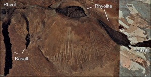
Bimodal eruptions produced both basalt and rhyolite in Kantaşı hill. There is a comenditic lava lake in the crater from which lava poured and flowed north. In some places the rhyolite covered earlier basalt flows on the flanks. Comendite is a type of hard, blue-grey rhyolite. Note small houses by the basalt flows on the left for scale. (GEarth image)
The last known lava flows in all of Turkey occurred in what is called in Turkish the Nemrut Opening Crack, along the extensional rift fissure and a parasitic cone to the N (Kantaşı hill, 1441–<1597 AD; lava flows and fountains). The fissure runs in several segments for 6 km outside the caldera and another four inside. The depths of the cracks vary, but reach up to max. 18 m in the so-called Nemrut Neck.

Rainbow obsidian from Nemrut Dağı. Obsidian from this volcano was the preferred material for their tools by Neolithic communities far and wide. (© 2017 Dr. Stephanie Flude, @TheNobleGasbag via Twitter)
The most spectacular feature of this rift zone is the bimodal activity. Şerefhan (1597) witnessed and well described the basaltic activity. He observed lava fountains “for years” and described the lava flow. Two (aa-like) basalt flows have travelled 890 m and 1.3 km, resp.. Another basaltic flow originates from the southern side of the Kantaşı hill and reaches 1.2 km towards the E. Basaltic lava flows are overlain by glassy rhyolite flow at the northern side of Kantaşı hill. The rhyolite flows may reach up to ~10 m thickness, while basaltic flows are ~2–4 m. There is a lot of evidence that the fissure is still active.

Mazik and Germav domes to the W of the volcano. The most striking feature of the Mazik dome is the NE–SW directed breach related to two faults on the top of it, and concentric faults at the southern flank of the dome. (GEarth image)
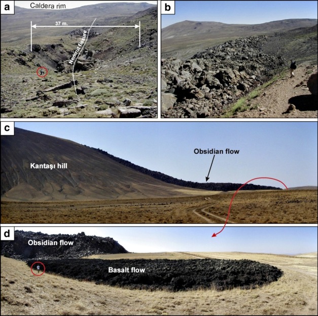
Effusive bimodal activity around Nemrut rift zone. a) Northern section of the rift zone with a large crack and domal obsidian knob in the middle, b) rift crack filled with comenditic obsidians, c) rhyolite flow throughout north flank of Kantaşı hill and d) underlying
basalt flow at the northern front of this rhyolite flow. Note people for scale. (Ulusoy et al., 2012)

Nemrut pyroclastics: a) Nemrut F2 unit and overlying Nemrut ignimbrite near Kıyıdüzü village, b) fallout and flow units of Nemrut ignimbrites, near Simek bay NE of Tatvan, show the yellowish to black/brown color change in the NeF3 fallout unit. The dark-brown welded ignimbrites are called Ahlat stones in the region.
THE NEMRUT VOLCANO EYES COMPETITION
Anatolia is a region that certainly needs a significant economical and structural upswing. Marketing the regional assets is only natural and desirable. So, next after building a cable car to the caldera rim and skiing area on the slopes, will probably be a humongous visitor observation platform to be constructed atop Nemrut. A competition last year had tasked participants with envisioning a device that would provide unobstructed views over the extraordinary caldera and its internal lakes, as well as the immense Lake Van to the east. A highly futuristic construction made the first prize, a mobile hot air balloon platform. All applications are supposed to be built on the edge of the caldera rim. Well… I don’t know… if there is a really stable spot on this big heap of rubble? Read the winner announcement and see the images in this short article HERE.

1st Prize winning entry “Upservatory”, a mobile hot air balloon platform, by Fernando Irizarry, Marcos Ortiz, and Gabriel Rivera (University of Puerto Rico). Image: Bee Breeders.
ANOTHER CANDIDATE FOR A FUTURE “DECADE VOLCANO”?
All these activities indicate that many villages in the region of Bitlis, Tatvan District and Gölbaşı district are at risk, be it from strong earthquakes or from a new eruption of Nemrut Dağı, which cannot be ruled out for the future. 1.6 Million people live within 100 km of the volcano, and still 230,000 in the 30 km radius. Now Nemrut volcano is also marked for large-scale tourism development… Should an eruption occur within the caldera – and the volcano is not painstakingly monitored – the waters of the huge caldera lake would pose the hazard of an unimaginable desaster for the region. I have seen studies in Turkish language from around 2012 where any possible hazard is only mentioned in one sentence, saying, like, Well, other scientists said there could be some danger…
It is a gratifying thought that a great lot of scientific work has been done in the last half century. Analyses of the Lake Van sediments have brought some better understanding of the chronology and activity of recent eruptions. The potential activity of Nemrut Dağı and the close proximity of several Turkish cities finally inspired in-depth studies that looked at the geological evolution of the volcano. In October 2003, the first in Turkey real-time seismic network of sensors has been installed around the volcano. During the first three years of operation the network has registered 133 earthquakes with a magnitude of 1.3–4.0 – 32 of them were volcanic events.
I close with a citation from Erkan Aydar et al., 2003:
“The present active tectonic regime, historical eruptions, occurrence of mantle-derived magmatic gases and the fumarole and hot spring activities on the caldera floor make Nemrut Volcano a real danger for its vicinity. According to the volcanological past of Nemrut, the styles of expected eruptions are well-focused on two types: (1) occurrence of water within the caldera leads to phreatomagmatic (highly energetic) eruptions, subsequently followed by lava extrusions, and (2) effusions/extrusions (non-explosive or weakly energetic eruptions) on the flanks from fissures. […] In the light of morphological analysis possible impact areas around the volcano and danger zones were proposed [in this study]. The possible transport pathways of the products of expected volcanic events are unified in three main directions: Bitlis, Guroymak, Tatvan and Ahlat cities, the about 135 000 inhabitants of which could be threatened by future eruptions of this [at that time] poorly known and unsurveyed volcano.”
![View east from Nemrut Dağı towards Lake Van, overlooking the low hills and peninsulas formed by ignimbrites and pyroclastic deposits that have flown into the lake. (© Herbert Frank from Wien [Vienna], AT; via Wikimedia)](https://volcanohotspot.files.wordpress.com/2019/10/nd21.jpg?w=627&h=470)
View east from Nemrut Dağı towards Lake Van, overlooking the low hills and peninsulas formed by ignimbrites and pyroclastic deposits that have flowed into the lake. (© Herbert Frank from Wien [Vienna], AT; via Wikimedia)
~~~
Disclaimer: I am not a scientist, all information in this (and any of my other posts) is gleaned from the www and/or from books I have read, so hopefully from people who do get things right! 🙂 If you find something not quite right, or if you can add some more interesting stuff, please leave a comment.
Enjoy! – GRANYIA
SOURCES & FURTHER READING
– GVP, Nemrut Dagi
– Impact of volcanism on the evolution of Lake Van I: evolution of explosive volcanism of Nemrut Volcano[…] (2013, paywalled)
– A Geological Study of Lake Van (1984, paywalled)
– Tatvan website, Nemrut
– Holocene-historical volcanism and active faults as natural risk factors for Armenia and adjacent countries (2002, paywalled)
– The Faults Near Bitlis and Seismicity of the Region (2012, PDF, Turkish)
– Volcanological evolution and caldera forming eruptions of Mt. Nemrut (2012, paywalled)
– Imaging the Crustal Structure Throughout the EAFZ (2019, paywalled)
– Morphological analysis of active Mount Nemrut stratovolcano, eastern Turkey: evidences and possible impact areas of future eruption (2003, paywalled)
– Stratigraphy of the Volcanic Products Around Nemrut Caldera:[…] (2005, PDF)
– The Nemrut Volcano Eyes competition






wow! fascinating find Granyia! Doesn’t need much imagination to see that this is an active beast of a volcano. Fascinating stuff. Though it is certainly not the second largest caldera lake in the world. Not be any means (NZ alone has three larger ones .. and then Taal in the Philippines, etc., you get the idea).
The remnant slab under an extensional setting makes sense to me.
LikeLike
Hi Bruce, good to hear from you! 🙂 You are right of course about the size, in the next sentence I state it’s the 16th largest. Seemed more convincing to me, so I didn’t check any further. Don’t know how that first had slipped in, have deleted it now.
Yes, it seemed logical to me too that the remnant slab could be the cause, though it is only cited in one paper, and as a possibility. The general consensus seems to be that the heavy push and stretch of the crust leads to extensional fault rifting, thus promoting volcanism. That doesn’t exclude the remnant slab, though. Perhaps more research is needed, or, more likely, I just haven’t seen the relevant papers.
LikeLike
extension alone doesn’t seem like to generate such explosive volcanism IMHO… though volatiles rising up and ponding in an extensional setting would do it nicely. Kind of intriguing that Lake Van appears to have been formed by a flow from the volcano damming the river. I wonder if they can get an age on those flooded settlements. Very intriguing place. And those stacks as well.. what great stuff!!
LikeLike
What a system. What a find. This one was really interesting. Cheers –
LikeLike