Mount Banahaw (or Banahao) is located on the island of Luzon, some 80 km SE of Manilla. At 2,158 m high, it is the tallest of a group of a stratovolcano complex that included San Cristobal (1,470 M) and Banahaw de Lucban (1,870 M).
As the largest mountain in this part of Luzon, Banahaw is revered as a sacred mountain with the land surrounding it considered to be holy land by the Tagalog people living in its vicinity. Sacred mountains and holy lands attract no small number of religious pilgrims. Large mountains also attract large numbers of climbers. The two groups keep local businesses very happy and busy.

Mount Banahaw looking south to north. New amphitheater from crater lake dump clearly visible. Image courtesy Thousand Wonders blog
As a spiritual mountain, Mount Banahaw is said to be a source of psychic energy, with numerous reported miraculous physical and spiritual healings. As such it attracts a variety of mystics, psychics, faith healers, hermits, religious pilgrims and cults. Religious visitors are said to commune with mountain spirits. Apparently, the mountain also has a number of caves which are inhabited from time to time by religious hermits.
There are multiple legends associated with the mountain. One holds that four Archangels made Mount Banahaw its home because of trouble in the Middle East. Another is that a Chinese woodcutter who joined a revolt against forced labor was dismembered by the Spanish. He came back to life and was transported to Majayjay near Mount Banahaw. A third has a famous mystic given names of holy places in the mountain by a Holy Voice. He visited the mountain to search for treasure. When he tried to leave, he lost his sight, which returned when he returned to the mountain. He stayed on as one of its hermits.

Waterfalls and streams on Mount Banahaw. Image courtesy Thousand Wonders blog
Waters from the mountain have historical and mystical importance. These include falls, streams and ponds. There are special springs with “Blessed Water” that are said to be effective cure for illnesses, forecast of fortune, and charm against bad spirits. An alternate local name for the mountain is “Vulcan de Aqua” due to these legends and the abundance of water even during the dry season.
As Banahaw is thought to be the home of good spirits, there is not enough good to go around. Neighboring San Cristobal is known as the “bad mountain” harboring bad or unfriendly spirits.
Banahaw and San Cristobal were declared a national park in 1921. There are eight rivers in the park. Jumping off point for pilgrims and mountaineers is Santa Lucia and Kinabuhayan to the SW. The largest neighboring town is San Pablo to the west. The entire park is ringed with small villages.

Mount Banahaw – San Cristobal Protected Landscape park. Lake Laguna to the top left. Pacific Ocean to the right and bottom. Screen capture from Google Maps
Visitors have not taken very good care of the mountain, littering the trails up and around it with trash. It got so bad that the Philippine Department of Environment and Natural Resources ordered a 5-year long halt in hiking in 2004. This was extended to Feb. 2015.
93,000 live within 10 km of the volcano. Nearly 24 million live within 100 km, mostly in Manila 80 km to the NW.
A 1994 paper discussing two debris avalanches from Banahaw by Sandra Geronimo-Catane reminds the reader that the Philippines have “… more than 200 active and inactive volcanoes, very few of which have received detailed volcanological investigations.” Granted, this was 25 years ago, but it was much easier to find information on the spiritual, psychic, bird and wildlife qualities of Banahaw and the surrounding national park than it was to find detailed geologic information on the volcanic system.

Quarternary volcanoes of Luzon Island. Inset is 1, Mt Palay-Palay, Mt Batulo, 2, Taal, 3, Mt Sungay, 4, Mt Macolod, 5, Anilao Hill, 6, Mt Malepunyo, 7, Mt Makiling, 8, Maar field, 9, Mt San Cristobal, 10, Mt Banahaw, 11, Laguna de Bay Caldera. Image screen capture from Ku, et al, 2009
Region
The Banahaw volcanic complex is located in the NE section of the Macolod Corridor, a volcanically active part of the Philippines. The corridor includes two calderas, three stratovolcanoes and hundreds of maars and scoria cones.
The Laguna Caldera is located in the NE portion of the corridor SE of Manila. It is a 10 x 20 km diameter caldera formed with two major eruptions 1 Ma and 27 – 29,000 years ago. Activity after the most recent caldera forming eruption took place on the SW rim of the crater.

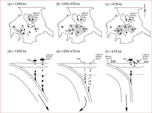
Migration of volcanic activity in Macolod Corridor over the last 2 Ma. Black triangles are quaternary volcanoes. Grey triangles are quaternary monogenetic volcanoes. Shaded grey areas are volcanic activity tied to each specific period. Image screen capture from Ku, et al, 2009
Taal is one of the most active and dangerous volcanoes in the Philippines, located in the SW portion of the corridor. It is located 80 km to the W of Banahaw. Its 15 x 20 km diameter caldera is largely filled by Lake Taal. There are several eruptive centers submerged by the lake. There have been 33 recorded eruptions from Taal since 1572. Recent major eruptions took place in 1572, 1911 and 1965. It has been quiet since 1977 with unrest since 1991.

Schematic of volcanoes of the Macolod Corridor with locations and ages. Image screen capture from Ku, et al, 2009
The middle section of the corridor includes the Mount Makiling and Mount Malepunyo stratovolcanoes. It also has hundreds of maars and monogenetic volcanoes.
The Macolod Corridor had two primary periods of explosive volcanic activity. The first 2.0 – 1.4 Ma and the second 0.5 Ma to the present. Large explosive eruptions migrated NE – SW over that time. The period of quiet is thought to be due to a period of adjustment of the subducted slab, steepening over that period. Large explosive volcanic activity took place at Laguna in the NE part of the corridor prior to 1.4 Ma. The period of relative quiet 1.4 – 0.5 Ma was dominated by small effusive eruptions, maars, dome building and small monogenetic eruptions. Large explosive eruptions migrated to the SW part of the corridor around Taal for the last 0.5 Ma.

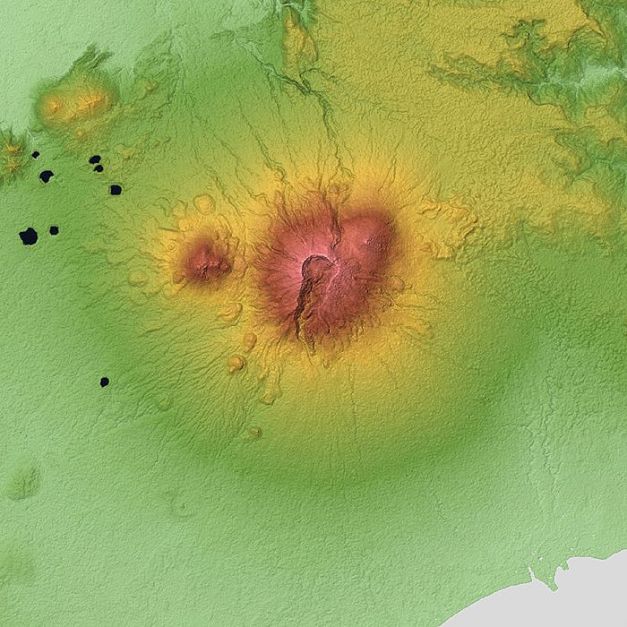
Topographic map of the Banahaw volcanic complex. From left to right San Cristobal, Banahaw in the center, and Banahaw de Lucban to the immediate right. Domes on the western and northern flanks clearly visible. New amphitheater from the 1730 crater collapse and crater lake dump clearly visible pointing mainly to the south. Image courtesy Wiki
Volcano and Eruptions
Mount Banahaw is an andesitic to dacite volcano. It has also erupted basalts. Satellite cones of San Cristobal are 7 km to the W and Banahaw de Lucban on its NE flank. Both satellite cones are newer than Banahaw.
It is located in the southernmost part of the Luzon Central Valley Basin. This basin was formed by filling a marine basin with dry land between the Zambales Range and the Southern Sierra Madre. The deepest parts of the basin have up to 6 km of sediment.
The Banahaw volcanic complex is constructed of volcanic materials lying on top of older marine sediments. The oldest of these from Mount Banahaw dates about 1.98 Ma to the present. San Cristobal is slightly more recent at 1.3 Ma. Banahaw de Lucban is the youngest, perhaps Holocene.

Mount Banahaw and Banahaw de Lucban to the right. Photo taken from the SE. Note hummocky land to the base of the parasite cone. Image courtesy Deztreks Insiders Guide to the Philippines blog
Original cones were all smooth but have been modified by erosion and two massive flank collapse avalanches. These may have been simultaneous with magmatic eruptions.
There are at least two major debris avalanches from Banahaw. One extends 13 km to the NE and the other 26 km to the SE where it forms 10 km of coastline. The second and larger debris avalanche to the SE forms an 8 km wide amphitheater now mostly filled by the Banahaw de Lucban satellite cone, the newest active volcano of the complex.
The most recent catastrophic physical change to Banahaw took place with the crater lake was breached and dumped to the SW. This left a second amphitheater, 2 km wide, pointing to the SW from the top of the volcano. This catastrophic water dump created mudflows (lahars?) in 1730. There were other historic eruptions that produced lahars / mudflows in 1743, 1843 and 1909. The Lucban blog lists the first recorded eruption of Banahaw as 1539. I have found no additional confirmation for that report.
The volcano has an active hydrothermal system with at least five hot springs in the vicinity.

San Cristobal on the western flank of Mount Banahaw. Photo taken from the south. Image courtesy Wiki
There are maar deposits in the vicinity of San Pablo. The Laguna cone and maar field are a neighboring volcanic complex with 42 scoria cones and 36 maars. Deposits associated with these include scoria fall, base surge, lapilli ash fall and lava flows. Two dated cones are 1.05 – 1.14 Ma, though local myth may have had eruptions as recently as 500 – 700 years ago.
The Kalbaryo dome complex is number of andesitic to dacitic domes on the flanks of Banahaw and San Cristobal. There are at least two phases of dome building. The first phase took place well within the last 50 – 100,000 years, during most recent growth of San Cristobal and Banahaw de Lucban. The second was more recent. The newer domes still have flow levees, clinkery surface and sparse vegetation coverage.

Schematic of both major debris avalanches from Banahaw. First and largest is to the east and south to the ocean. Second and smallest is mainly to the east and somewhat to the north. Screen capture from Geronimo-Catane, 1993
Debris Avalanches
The debris avalanches at Banahaw were discovered relatively recently by Geronimo-Catane and Ui in 1992. Their work was based on observations of hummocky topography near the volcano that they attributed to erosion deposits from Banahaw de Lucban. Upon further investigation, they discovered two distinct flow lobes from two distinct debris avalanche events.
The notion of a debris avalanche is a relatively recent discovery, falling out of the observation of the Mount Saint Helens eruption in 1980. These descriptions were first proposed in 1984 and today are thought to represent a major process in stratovolcanoes.
Debris avalanches are identified by an amphitheater on the upper slope of the volcano. Below that amphitheater are hummocky deposits with hills, mounds and ridges separated by flat areas. Within the avalanche there is an unsorted mixture of old rocks from the volcano. An avalanche associated with an eruption will have new material mixed in with or on top of the debris flow.

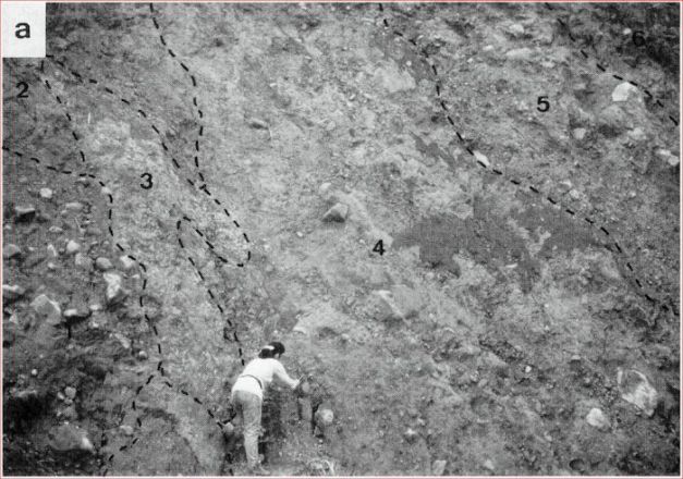
Hummock exposure of the Lucban debris avalanche. 1, Boulder-rich lahar, 2, Hydrothermally altered fallout deposit, 3, Dacitic pyroclastic flow deposit, 4, Laminated lahar, 5, Pebbly lahar, 6, Recent lahar cap Screen capture from Geronimo-Catane, 1993
The first and largest avalanche (Lucena) to the SE removed about a vertical kilometer from the NE side of the cone. It moved some 4 km3 of material and created an amphitheater 8 km wide. Avalanche deposit stretches 26 km to the SE. There is an irregular shoreline to the SE that suggests the deposit extends some distance into the ocean.
The second (Lucban) avalanche took place later and moved perhaps 1 km3 of flank material 13 km to the E and NE. This one shares the northern boundary of the amphitheater.
The researchers did not find carbonized wood that would have been created had this been a hot avalanche. On the other hand, they did find juvenile fragments mixed with the avalanche deposit that indicates a magmatic eruption may have accompanied the collapse. There are two possible scenarios for the juvenile fragments. The first is that an eruption immediately preceded the avalanche. The second is that the avalanche and eruption were nearly simultaneous (like Saint Helens) where the juvenile material was ejected from an open vent.

Schematic of competing theories of debris avalanches from Banahaw. Single stage is at the top. Two stage collapses depicted in part B a – d Screen capture from Geronimo-Catane, 1993
There are significant lahar deposits associated with the avalanche deposits. These either overlie or are on the same layer as the avalanche deposits. They are thick, massive and poorly sorted. Internal structure suggests that the secondary lahar deposits were due to saturated avalanche material that converted into a lahar as soon as it was deposited, massive rainfall during or just after the avalanche, or the breakout of temporary lakes. There are no secondary lahar deposits associated with the second debris avalanche, meaning it was a drier event.
There is still some discussion about how these avalanches proceeded. Initial suggestion was a single massive avalanche with two lobes. More recently, it appears separate collapse events separated by a significant repose period between the two is a better explanation.
At the end, it appears the Lucena avalanche took place first. It was accompanied by a short magmatic eruption. Cone building then began and took place for an extended period of time. This was followed by second collapse which deposited the Lucban avalanche. Resurgent volcanism then completed construction of the Banahaw de Lucban cone which occupies the remnant amphitheater.

Annotated schematic of Philippine Sea Plate. Note east to west subduction north of Taiwan and south of mid-Luzon. Note west to east subduction between mid-Luzon to Taiwan. Image courtesy Tectonics of Asia blog
Tectonics
I partially covered the tectonics of this part of the Philippines in a post on Pinatubo in 2015. That discussion is still a decent place to start.
Volcanic activity in the Philippines is driven by the subduction of the Philippine Sea Plate westward beneath the Eurasia (Sundaland) Plate. The Philippine Sea Plate is unusual in that its major boundaries are all in subduction. Convergence toward Luzon is in the neighborhood of 100 mm/year. Thickness of the plate varies 29 – 41 km and is thought to be based on the relative age of the seafloor.
Subduction related earthquakes in the M 8+ range have taken place during the last 120 years along the western subduction arc. Earthquakes in the M 7+ range are common.

Schematic of tectonic setting and GPS velocities in northern Philippines. Image courtesy Hsu, et al, 2016
The Philippine Sea Plate had multiple rotation events in its 50 Ma year history. The most recent of these began 25 Ma.
Another oddity is a region stretching roughly from Taiwan to west of Luzon where the Eurasian Plate is subducting under the Philippine Sea Plate. To the east of Luzon, there is another subduction zone where the Philippine Sea Plate is subducting under Luzon. This is interpreted as a tear in the northern region of the Philippine Sea Plate, allowing the heavier South China Sea floor portion of the Eurasian Plate to be dragged underneath the Philippine Sea Plate.
This tear, in turn opens a window for upwelling of asthenosphere fluids under Luzon and the region between Luzon and Taiwan.
The western side of Luzon has the Philippine fault, a mega-fault caused by the subduction underneath Luzon. The subduction location offshore is called the Philippine Trench.

Benham Rise. Image courtesy Philstar Global, Oct. 2019
Benham Rise and the Apolaki Caldera
While not specifically related to this particular volcano, Granyia came across a paper by Barretto, et al in September analyzing the Benham Rise to the east of Luzon and the subduction zone: Morphology and structure of an Eocene large igneous province in the West Philippine Basin. The research group of marine geophysicists believes they have found what may very well be the largest caldera in the world at 150 km on the bottom of the Pacific Ocean. It appears that a Large Igneous Province built 48 – 42 Ma. It was greater than 301 km in diameter. Magma source was a triple junction in the vicinity of the LIP. Caldera formation in the middle of the LIP appears to be largely non-explosive, and for the most part due to withdrawal of magma beneath the surface. There are explosive components to the caldera creation, though. Caldera formation was followed by construction of a resurgent dome. Post caldera activity ended around 26 Ma.

Schematic of suspected Apolaki caldera on the crest of the Benham Rise. Screen capture from Barretto, et al, Sept. 2019
I find the suggestion that a caldera some 2.5 times larger in diameter than the largest we know of to be little more than astounding. And extraordinary claims require extraordinary proof. Looks like these guys have made a good start with a lot more to do in the future to prove their conclusions. The pdf can be found at the link above. Well worth your time to read.

San Cristobal (bottom left) and Banahaw from the air looking east. Image courtesy Lucan blog, 2016
Conclusions
One of the problems PHIVOLCS has with Banahaw is the sheer amount human traffic on what is potentially still a very dangerous mountain. They are attempting to change the way the volcano is viewed locally by calling it Banahaw Volcano rather than Mount Banahaw. There are multiple hot springs in the region, which means it has an active hydrothermal system. The volcano itself produced at least two major Holocene debris avalanches. These avalanches created an 8 km diameter amphitheater that the current Banahaw de Lucban stratovolcano built in. The most recent amphitheater from the summit crater of Banahaw is 2 km in diameter, created when it dumped its crater lake in 1730. Given the weak structural cone of Banahaw and the large quantity of rain in the tropics (the Philippines also get hit with Typhoons on a regular basis), at a minimum future lahars and mudflows should be expected. Should the mountain once again become active, it will be difficult to control the number of people on it, making the potential for loss of life significant.

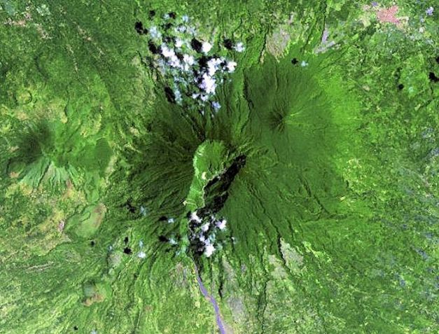
Landsat image of Banahaw volcanic complex. Satellite volcanoes clearly visible to the left and on the upper right flank of the main volcano. Image courtesy Hawaii Synergy Project, University of Hawaii via Smithsonian GVP, 2002
Additional information
https://volcano.si.edu/volcano.cfm?vn=273050
https://www.atlasobscura.com/places/mount-banahaw
https://www.vigattintourism.com/tourism/articles/The-Mystic-Tale-of-Mount-Banahaw
http://www.malapascua.de/Volcanoe-Map/Mount_Banahaw/mount_banahaw.html
https://www.thousandwonders.net/Mount+Banahaw
https://www.silent-gardens.com/philippines-volcanoes.php#Laguna_Caldera
https://tectonicsofasia.weebly.com/philippine-sea-plate.html
https://earthobservatory.sg/resources/images-graphics/subduction-zone-beneath-philippines
https://www.jstage.jst.go.jp/article/kazan/39/3/39_KJ00003418747/_pdf
https://tel.archives-ouvertes.fr/file/index/docid/794267/filename/Paguican-2012CLF22255.pdf
https://agupubs.onlinelibrary.wiley.com/doi/full/10.1029/2009GC002486


Pingback: Mount Shasta, California, USA |
Magmatic arc of Mt banahaw
LikeLike
You have concerns about Banahao???? “Holy ‘Mount Vesuvius”, Batman!
LikeLike