
Lemei Rock in Indian Heaven volcanic field. Image courtesy Outdoor Project, Fall Color in Indian Heaven Wilderness, WA, Lisa Holmes, 2014
The Indian Heaven is a volcanic field in Skamania County in far southern Washington state, US. It lies roughly midway between Mount St Helens and Mount Adams in the Cascades. The field dates from Pleistocene to early Holocene with the most recent eruption around 8,200 years ago. The USGS rates its current eruptive threat as low.
There are around 60 eruptive centers in the field. Most of them are monogenetic, though there are at least eight basaltic shield volcanoes that erupted multiple times. They are generally topped by cinder and spatter cones. There are also subglacial vents (tuyas) and multiple lava flows. Individual lava flows contain extensive lava tubes. The longest flow is around 46 km. The most recent eruption produced the 0.9 km3 Big Lava Bed, a basaltic lava flow that traveled nearly 25 km, getting within 8 km of the Columbia River.

Google Maps screen capture of vicinity of Indian Heaven volcanic field (red tab). Mount Adams to the upper right. Mount St Helens to the upper left
The field is 30 km SW of Mount Adams. It covers 600 km2. 80% of the eruptive products are basalts, though there are some andesites. Total eruptive volume of the field is estimated at nearly 100 km3. This is the most voluminous field of recent basalt in the Cascades north of Newberry in central Oregon. The vents are generally aligned along a N-S axis creating a highland roughly parallel to the Cascades. The highest point is Lemei Rock, topping out at 1,806 m.
The field is surrounded by the Indian Heaven Wilderness, a national wilderness area within the Gifford Pinchot National Forest. The local area has been inhabited by Native American populations for much of the last 10,000 years. The name derived from the indigenous name for the locale. The wilderness area is a popular recreation area with camping, trails and over 150 lakes for fishing, swimming, and boating.

Blue Lake in Indian Heaven volcanic field. Image courtesy Outdoor Project, Fall Color in Indian Heaven Wilderness,, WA, Lisa Holmes, 2014
The Indian Heaven Wilderness is a forested high plateau. It is generally subalpine meadows and forests. The trail network is at least 68 km long. The area is relatively inaccessible, with roads being snow covered generally until June. Snow is normally gone by mid-July, allowing visitors in late summer and fall before the snows return. Many of the area lakes are stocked with rainbow trout and landlocked salmon. Cutthroat trout and muskellunge are also available. Like many sub-Arctic regions, mosquitoes are thick in the summer, leading to an informal description of the area as Insect Heaven.
Multiple tribes used the area for fishing, hunting and (huckle)berry picking.
The Gifford Pinchot National Forest is one of the older national forests in the US located in mountainous part of Washington State. The first chunk was designated in 1897. It stretches roughly between Mount St Helens t the W, Mount Adams to the E, Mount Rainier National Park to the N and the Columbia River to the S with a total area of 5,300 km2.

Geologic map of Mount Adams volcanic field (MAVF) and surrounding volcanic fields. Mount St Helens, center left. Goat Rocks, center right. Indian Heaven volcanic field (IHVF). Simcoe Mountains volcanic field (SMVF). Image courtesy Hildreth and Fierstein
Neighboring Volcanics
The field is located in SW Washington State about 40 km SE of Mount St Helens and 30 km SW of Mount Adams. St Helens and Adams are around 64 km apart. It also lies mostly on the SW flank of Mount Adams but is sufficiently distant and distinct so as to be viewed as a separate volcanic field. The field is mostly on raised terrain bounded on the N and E by a pair of lahar hazard zones off Mount Adams to the NE.
St Helens is the youngest, most frequently active and most explosive of the Cascades volcanoes, last erupting 40 years ago in 1980. Over the last 4,000 years, it has produced multiple lahars, a variety of volcanic eruptions ranging from relatively quiet effusive eruptions producing lava flows and domes to explosive ones much larger than the 1980 blast. In the last 515 years, it has produced four major eruptions and multiple smaller ones. The 1480 eruption was 5x larger than the 1980. Even larger eruptions took place in the past.

Mount Adams. Image courtesy Ever Wild, a lifetime on Mount Adams, Darryl Lloyd, Mount Adams book
Mount Adams has not been as active over the last several thousand years. Its most recent activity was a series of small eruptions 1,000 years ago. There was a debris avalanche and lahar some 500 years ago. The associated volcanic field covers some 800 km2. Highly explosive eruptions from Adams are rare, with most eruptions being effusive producing lava flows. Eight lava flows over the last 10,000 years traveled 13 – 32 km and covered around 50 km2. They were several meters to more than 30 m thick, with crusty lava blocks enclosed a more fluid core. Flow fronts are steep and advanced quite slowly. Lava flows are the most likely type of future eruptive event. The most serious ongoing threat from Mount Adams are landslides and lahars not caused by eruptive activity.
Its cone was built during the last 40 – 10,000 years. Much of it has been eroded by glaciers, forming steep, unstable slopes. There is an active hydrothermal system that has turned the upper 2 km3 of the cone into mud, making it far more prone to landslides, debris avalanches and lahars. The largest of these travel more than 50 km through neighboring river valleys.

Simplified volcanic hazards map of Mount Adams. Indian Heaven volcanic field SW of Adams. Image courtesy USGS, 2013
In the last 10,00 years, the upper slopes produced several large debris avalanches. The most recent of these in 1921 traveled some 6 km. There are larger and older debris avalanches and lahars, the largest, the Trout Lake avalanche and lahar, which took place some 6,000 years ago, traveling some 55 km from the volcano. The lahar deposit in the lowlands varies from 1 – 20 m thick. These events were not connected to volcanic activity. However, future eruptive activity would most certainly increase the likelihood of future debris avalanches and lahars from Adams.

Summit of Old Snowy, eroded remnant of Goat Rocks volcano. Hiking trail clearly visible on the crest of the ridge to the left. Image courtesy High Sierra Wiki, 2003 Goat Rocks Wilderness Hikes, Peter Tremayne, 2018
The White Pass – Goat Rocks area has been active since 4 Ma, producing at least 25 volcanoes and over 175 km3 of material. Activity 4 – 2.8 Ma built domes, tuff and shallow, unerupted magma intrusions. Goat Rocks itself is located some 32 km N of Mount Adams. It is a heavily eroded stratovolcano. South of White Pass, many layers of welded rhyolitic tuff built a 650 m thick section on the E flank of Goat Rocks. There is a partial caldera margin mapped. Silicic volcanism ended 3 Ma. Since then, eruptions switched to basalts with some large volume lava flows. Some of the main cone of Goat Rocks may be as young as 1 Ma. There are more than 200 basaltic and andesitic lava flows constructing he Hogback Mountain shield volcano S of White Pass. Most recent volcanism switched to the Tumac Plateau N of White Pass building basaltic shield volcanoes. The youngest of these last erupted 30 – 20,000 years ago. There are multiple recent lava flows extended as far as 25 km S from Goat Rocks to Mount Adams. The most recent of these is the subglacial Walupt Lake volcano that may be as recent as 18 – 15,000 years ago.

Haystack Butte lava flow, part of the Simcoe Mountains volcanic field. Image courtesy Reading the Washington landscape blog, Dan McShane, 2019
The Simcoe Mountains volcanic field is 64 km E and SE of Mount Adams that erupted through the Columbia River Basalt Group in three periods between 4.2 – 0.6 Ma. Neighboring Goat Rocks stratovolcano was active about the same time as Simcoe Mountains. There is a N-S line of at least 24 cinder cones that center of the field, with another 12 cones to the SE. The oldest eruptive units are rhyolite in the eastern Simcoe Mountains. These were erupted around the same time as Simcoe basalts. The basalts are short 6 – 10 m thick flows, some in the 1 – 6 m range. They extrude from small shields and cinder cones. The oldest units date 4.5 – 0.9 Ma. There is a shield volcano and associated lava flows E of Adams that form the Lincoln Plateau. These are likely younger than 0.9 Ma. The youngest unit is a dacite that forms Signal Peak E of Mount Adams. It is dated 1.0 – 0.5 Ma.

Shaded topographic map of Indian Heaven volcanic field. N is up. Image courtesy Wiki
Indian Heaven Volcanic Field
The Indian Heaven volcanic field has 60 – 70 eruptive centers along a 30 km long generally N – S trending fissure zone. The field covers some 600 km2 with a volume of around 250 km3. Total volume is similar to neighboring stratovolcano complexes and volcanic fields. It is the western portion of a larger 2,000 km3 basalt field E of Mount St Helens in the southern Washington Cascades. This included the King Mountain fissure zone that Mount Adams was built on.
The field was active for much of the last 700,000 years with estimates ranging as old as 3.75 Ma. Magnetic field analysis tends to support the 700,000-year activity start. Radiometric dating tends to support the older number. I have found nothing that reconciles that discrepancy as yet. The field was active during at least four glacial cycles, and these have helped date activity in the field.

Sawtooth Mountain, Indian Heaven volcanic field. Image courtesy University of Arizona Nodal Array, 2017
All lava flows are normally magnetized, meaning they are assumed to be younger than the last magnetic field reversal some 730,000 years old. The youngest eruption created the Big Lava Bed around 8,200 years ago. Many of the lava flows erupted from a N – S trending zone of coalescing volcanic centers. These erupted at least 14 groups of lava flows. Each center is a broad shield volcano, erupting mainly pahoehoe and a’a lava flows, with one of more cinder and spatter cones on the flanks.
There have been at least four major periods of glaciation as the field was active. An ice cap covered the northern end of the field some 130,000 years ago. The Lone Butte tuya erupted though the glacier which was 230 m thick at the time of eruption. It grew to at least 1,000 m above its base. Erosion removed about half of its original structure. Other subglacial eruptions formed pillow lavas and hyaoclastic deposits.

Red Mountain, Indian Heaven volcanic field. Image courtesy Lee Siebert, Smithsonian GVP, 1995
The field is dominated by small shield volcanoes surrounded by cinder and spatter cones. There are subglacial vents on the NW flank of the field. Most of the shield volcanoes have base diameters of 10 – 15 km. Central vents rise around a kilometer above the base. At least one paper suggested it is possible to model the entire field as a large, complex shield volcano fed by a central reservoir that supports multiple flank vents.
The field has several overlapping shield volcanoes along a line between Sawtooth Mountain to the N and Red Mountain to the S. The line includes cinder cones, lava cones, spatter cones and lava flows. Total volcanic output is estimated at 250 km3. Half of the vents create a highland 31 km long. Most of the volcanoes are monogenetic.
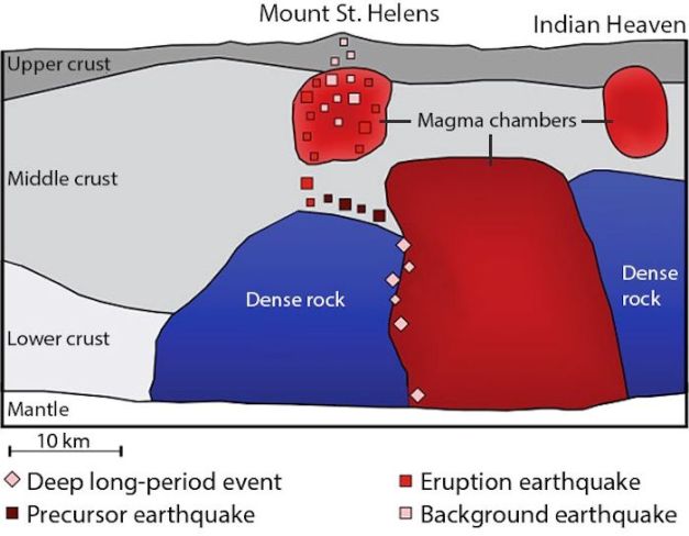
Schematic of suggested active magma chambers beneath Mount St Helens, Indian Heaven and locale. Image courtesy Michael Byrne, Vice.com, 2015
The field occupies a gravity low that may reflect light tertiary rocks below the field, hydrothermally altered or fractured zone or even a shallow magma chamber below the field. Tomography in 2016 led to the conclusion that the magmatic system under Indian Heaven is still active and that magmatic fluids may still exist. Problem with this conclusion is that earthquake detection in the area is relatively poor. 95 seismometers were deployed in the summer of 2017 and recorded data for 30 days. 305 seismic sources were detected near the field over that time.
The field follows the direction of regional extension, faulting and overall volcanism in the Cascades. The region is volcanic, underlain by more ancient volcanoes that subsided due to parallel N-S faulting in the region. These volcanic rocks date from Eocene to Miocene. Underlying volcanic products include andesites, tuffs, mudflows, pyroclastic flows and tephras.
Current volcanic threat estimate from the USGS is low / very low, though the last eruption did produce a large mobile lava flow.

East Crater (lower left, Lemei Rock and Bird Mountain, Indian Heaven volcanic field. Image courtesy Wikimedia Commons
Major Vents
Major vents include Big Lava Bed, Bird Mountain, East Crater, Lemei Rock, Lone Butte, Red Mountain and Sawtooth Mountain.
East Crater is a shield volcano with a seasonal lake and meadow. Crater rim is covered in red volcanic rock. There is a small lake on the W side of the crater. Multiple pahoehoe lava flows erupted from a bocca on the W side of the volcano. Cumulative thickness is 24 m, volume of 0.5 km3, and estimated age around 30,000 years old.
West Crater is an andesitic dome with two large lava flows. It erupted around 8,060 years ago. The dome has a summit crater 200 m wide and 24 M deep. This dome erupted a black tephra covering nearly 2 km2 and appears to be similar in age with neighboring Bare Mountain and Hackamore Creek scoria cone, meaning all three structures were formed by the same magma pulse.

Berry Mountain (left), Gifford Peak and East Crater (R) are all small Pleistocene shield volcanoes topped by pyroclastic cones. Image courtesy Lee Siebert, 1995 via Smithsonian GVP
Lemei Rock is the highest point in the Indian Heaven wilderness. There are several buttes around the crater. Lemel Rock is the eroded center of a shield volcano in Indian Heaven. It is the both the youngest shield volcano and the highest peak within the wilderness area. It is topped by a volcanic crater. The rim is generally free of snow and ice, though it tends to linger on the summit well into July. There is a small crater lake in the crater. Multiple creeks flow off the edifice and feed into surrounding lakes and rivers.
Lone Butte is a 1,460 m tuya that erupted either during the glaciation 150,000 – 130,000 or 90,000 – 70,000 years ago. The most recent eruption at Lone Butte took place around 12,000 years ago.
Red Mountain was originally a shield volcano that erupted some 170,000 years ago topped with red cinder cones.
Sawtooth Mountain is a heavily eroded shield volcano active some 250,000 years ago. Cumulative thickness of all blocky andesite lavas is 122 m. Total volumes estimated at 3.4 km3.
Source of Big Lava Bed flow is the cinder cone to the right. Flow is banked on the flanks of the cinder cone and traveled S within 8 km of the Columbia River. Image courtesy Lee Siebert, 1995 via Smithsonian GVP
Lava Flows
Typical lavas are pahoehoe and a’a. Some of the andesites are block lava flows. The field produced large volumes of basalts indicating little crustal melting as the magma rose to the surface. There are smaller amounts of andesitic basalts. Dacites are not common among erupted products.
The field produced little tephra, though it was overlain by ashfall from St Helens and Mazama. There are at least 40 distinct lava flows in the field, most of them pahoehoe with smaller amounts of block and a’a flows. Thicknesses vary from 0.4 – 24 m with total area coverage by lava at 116 km2. Indian Heaven basalts are generally more primitive than neighboring volcanic structures and fields.

Bike trail on the foot of Big Lava Bed. Image courtesy Dirty Freehub, Captain ‘O’, 2020
Big Lava is bounded by forest roads along the NE and E boundaries of the flow. There are no trails inside the lava flow. The most recent Big Lava Bed is known for multiple lava tubes and inflation of feeder tubes when they were clogged. Visitors are advised to choose their route carefully as compasses are not always reliable due to local magnetic effects of the lava.
The main basalt flow units date as follows (from Diane Smith, 1984):
- Big Lava Bed – 8,200 years ago. Source is a 300 m cinder cone in the N center of the bed.
- South Prairie, Twin Buttes – 12,000 – 3,500 years ago. Twin Buttes has cumulative lava flow thickness of 30 – 120 m. Flanks of the buttes have a significant amount of scoria.
- Burnt Peak, Ice Caves, Hidden Lakes – 20,000 – 12,000 years ago. Crazy Hills is the source of the Burnt Peak basalts. These were subglacial deposits of pillow lavas and hyaloclastic breccias and tuffs. Lavas are sourced from at least six separate vents. Total thickness is 60 – 100 m with an estimated volume of 1.71 km3. The basalts formed during the most recent glaciation 22,000 – 13,000 years ago.
- Forlorn Lakes, Black Creek, Outlaw Creek – 130,000 – 20,000 years ago
- Mosquito Lake, Rush Creek – 140,000 – 130,000 years ago
- Flattop Mountain, Little Deer Point – 690,000 – 140,000

Ape Cave, Big Lava Bed, Indian Heaven volcanic field. Image courtesy AF Litt, Rubble Blog, 2012
The field is dominantly basaltic, though basaltic andesites and andesites occur. The Mann Butte is a rhyolite dome east of the field. Perhaps half of the basaltic andesites and andesites erupted on the flanks of the field, likely from stranded magma bodies that fractionated before erupting.

Schematic of Cascades from Northern California to British Columbia. Image courtesy NPS, 2020
Tectonics
Volcanic activity in the Cascades has been active for 36 Ma, though there are older volcanic rocks. Activity is driven by the subduction of the Juan de Fuca Plate beneath North America. Convergence between the two plates continues around 4 cm/yr toward the NE.
Volcanic activity has been sporadic, with the most recent episode beginning 5 Ma and building over 3,000 vents. The new terrane portion in Oregon is called the high Cascades; the old portion, the Western Cascades. These terms do not apply in Washington state where the volcanic vents are scattered across Miocene and older terrane. Terranes constructing Oregon and Washington are rotated a bit with the older terranes being a bit more rotated. The rotation may be related to original trend of the Cascades NW rather than northward. Or it may be related to shear along NW-trending faults between regional blocks, microplates or terranes. Both models kind of work to describe what is seen, so there is no conclusion as yet.

Schematic of buoyant asthenosphere accumulating beneath subducting Juan de Fuca Plate. Image courtesy Hawley, et al, 2016
Young volcanism varies with geography. N of Mount Rainier, it is concentrated in only a few isolated andesitic and dacitic composite cones (Glacier Peak, Mount Baker, Garibaldi volcanic belt in British Columbia). South of Mount Hood, moderate sized andesitic and dacitic stratovolcanoes are located in a region dominated by small andesitic and basaltic vents. The area between Rainier and Hood is transitional. Large stratovolcanoes (Rainier, Adams St Helens, Hood and Goat Rocks) are co-located with basaltic volcanic fields (Indian Heaven, Simcoe Mountains, King Mountain fissure zone S of Mount Adams).
The subducted Juan de Fuca Plate dips around 65 degrees to 300 km under the southern Washington Cascades. It is poorly defined seismically due to a lack of earthquakes within it. The volcanic front traces the 60 km depth contour. There is a 90 km gap with no young volcanoes between Rainier and Glacier Peak. South of Portland, the volcanic front is offset 50 km eastward and extends southward into California, likely still parallel to the convergent margin.
Continental crust below this region is 40 – 45 km thick. The depth of the subducting plate is 60 – 70 km 100 km W of Mount Adams and should be around 100 km deep under Adams and the neighboring volcanic fields. The slab dips around 25 degrees. Magmas from St Helens and Indian Heaven are not chemically similar to magmas from subducted oceanic slabs (low in Strontium, for instance) and are thought to come from other mantle sources.

Indian Heaven traverse from Lemei – Bird – Sawtooth (foreground). Image courtesy Oregon Hikers.org 2015
Conclusions
There is clearly a lot going on in this portion of Washington State, though outside Mount St Helens, there have not been recent eruptions. Still, a magma body appears to exist beneath the Indian Heaven volcanic field and its last eruption was quite large in volume. Any remote, relatively unmonitored volcanic field with a history of large recent eruptions should be closely watched.

Lemei Rock from Little Huckleberry Mountain. Image courtesy mapio.net
Additional information
Smithsonian GVP – Indian Heaven
USGS Volcanic Hazards Program – Indian Heaven Volcanic Field
Volcano Discovery – Volcano Heaven
USFS – Gifford Pinchot National Forest – Wilderness: Indian Heaven
Volcanic Hazards – Oregon and Washington
AAAS Science – Deep magma chambers seen beneath Mount St Helens, 2015
Wikimedia Commons – Indian Heaven Volcanic Field Digital Relief Map
USGS – Volcano Hazards in the Mount Adams Region, WA
Rubble – SW Washington Lava Caves, Sept 2012
Seismicity beneath the Indian Heaven Volcanic Field, Washington State, USA, Moussa, et al, 2018
Final – Hazard Volcano, WA State Hazard Mitigation Plan, Tab 5.10, 2012


Massive earthquake M8.2 some 800km SW Anchorage. Was felt in town as a lengthy roller. Interesting story. Fished Seward Weds AM and drove home after noon. Quake happened that night 1015 PM L. Had the trip been a day later, would have been bounced out of the hotel by the tsunami warning for half the night. They take tsunamis pretty seriously in Seward. Decent writeup of the quake via UAF Seismology Lab at link below. Cheers –
http://earthquake.alaska.edu/largest-earthquake-50-years-what-we-know-so-far
LikeLike
Reblogged this on battleoftheatlantic19391945 and commented:
RED FRIDAY, in GREAT #1, U.S.A., February 25, 2022-WELL, IT IS ABOUT TIME; as more than precisely I have BEEN SEARCHING for a TRAVELING BLOG-POSTING…FOR OVER a HOUR, and THEN SOME!!! The GREAT STATE of WASHINGTON, U.S.A. Been there IN 1981, THEN AGAIN; for a LONGER PERIOD OF TIME…AND SEVERAL TIMES, IN 1998 TO 2002!!! WA., IS VERY-SOMEWHAT SIMILAR; in its MOUNTAIN RANGES AREAS, to British Columbia, Canada, AND IN SUMMER TRAVEL TIME…GET READY FOR SOME VIEWING, SCENERY, CAMERA-READY-ACTION; WILDLIFE, MOUNTAINS, RIVERS, LAKES, DESERT, APPLE TREES, SCENERY, GOOD FOLKS, BEAUTIFUL AMERICAN WOMEN-BABY DOLLS, I’ll have ANOTHER OLY…OLYMPIA BEER, HONEY…IT’S THE WATER…OLY…Olympia Beer, Glacier Water from MOUNT OLYMPIA….and also RAINIER BEER, from the SAME-MOUNT RAINIER…Great Food, Excellent Summer Weather, THE EVERGREEN STATE…EVERGREEN TREES GALORE, and THEN SOME!!! OREGON-To the SOUTH, then South of OREGON…THE STATE EVERYONE ALWAYS WANTED TO GO….SUNNY CALIFORNIA, U.S.A. To the EAST of WA., WASHINGTON is IDAHO, ID; ANOTHER MOUNTAINOUS BEAUTIFUL STATE…WITH MUCH NEEDED TOURISTS…AS ITS BEAUTY…IS REMARKABLE!!! WHAT, more than precisely CAN I SAY? WELL, LAST VISIT to U.S.A., 1998 TO 2002; I came OVER THE BORDER from British Columbia, Canada, INTO WASHINGTON, U.S.A., and TRAVELED FOR 4 AND 1/2 YEARS…AS I LOVED AMERICA/U.S.A., SO, SO, MUCH!!! NOW, I have SETTLED DOWN; THOUGH, WILL NEVER REGRET MY TRAVELS TO, AND IN 50 CONTINENTAL STATES IN THE NUMBER ONE COUNTRY IN THE WORLD; THE U.S.A. To COME TO a CLOSE ON THIS BLOG-POSTING; THE TUNE-SONG…I’VE BEEN EVERYWHERE, MAN…and THEN SOME!!! Thanks for the MEMORIES, AMERICA=1979-1980-1981/Visit Only…1983-Visit-Vacation Only, 1985-1986…1998 TO 2002…LOVE Y’ALL AMERICA…Later, Brian CANUCK-THE BREEZE Murza, Niagara Falls, Ontario…then Vancouver, British Columbia, Mount Hope, Ontario, Canada.
LikeLike