

“On June 24, 2015 the Indonesian PVMBG raised the level of activity of G. Colo from “Normal” (Level I) to “Alert” (Level II)”.
Have you ever heard of G. Colo? I had not before this notice. Yet some tourist businesses tell you that, though it might be almost impossible to reach that place, you’ll find it still harder to leave… so off to Google Maps and see what is there!
Yesss, this is the place that has everything to the heart of Robinson the Volcanoholic! A small island called Unauna in the middle of the Gulf of Tomini, one of the Togian Islands, in Central Sulawesi. Colo means “match” or “lighter” in the local language Bugis. Just 11 km across, and consisting entirely of Gunung Colo, the stratovolcano, which is no more than 507 metres (1,663 ft) high. It has a 2 km (1.2 mi) wide caldera with a small volcanic cone inside. The entire island is covered in lush green vegetation, there are beautiful paths of past mudslides and lahars, great dirty-brownish beaches, smelly fumaroles, scalding hot waterfalls and two or three villages on the east side…. it cannot get any better! (I am not being sarcastic, I really think I would love it!)

Caldera Floor. Photo: Aris Yanto
RECENT UNREST
I was amazed to find this little volcano among the most dangerous volcanoes of Indonesia on place 6 or 7, if the listing order was anything to go by. We will see later why it is considered that. But first let’s watch this short video from inside the crater. As the volcano from the outside doesn’t look much like your garden variety volcano, the crater looks even less like its brothers:
Hydrothermal activity n the crater of Colo volcano. By Aris Yanto, via YT.
Of the hightened activity there is not much to report as yet, here are some facts from the June 24, 2015 PVMBG evaluation (transl.: Google) – Summary:
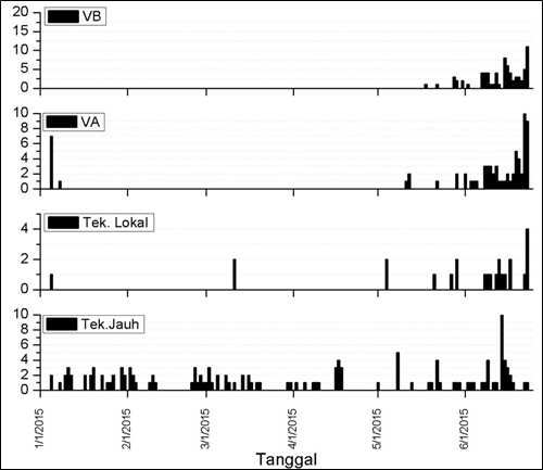
Colo Activity Report 2015-06-24 Seismic Events
G. Colo seismic monitoring results showed a significant increase, particularly in volcanic earthquakes (VA) and Shallow volcanic earthquakes (VB), since June 8, 2015. The number of volcanic earthquakes In (VA) on June 22 is quite high at 12 events, which previously only recorded 1-5 episodes per day. Number of shallow volcanic earthquakes (VB) on June 23 is a total of 11 events, which previously recorded only 1-8 episodes per day. This type earthquake may indicate a process of breaking volcanic rocks in the edifice due to the pressure of magma to the surface. Other seismicity recorded is the Far Tectonic earthquake (TJ) and local tectonic earthquakes (TL). – Visually, until now we have not seen significant changes, nor was observed any smoke from the crater.
G. Colo potential hazards
– Historically, eruptions that occurred in G. Colo were explosive magmatic and were accompanied by pyroclastic flows, especially to the southeast and southwest. Additionally, the region in the northeast to southeast has the danger of lava flows.

Colo Volcano, Unauna, Hazard Map. Click to enlarge.
– The the current observation data indicate that G. Colo has the potential to experience a phreatic eruption suddenly, although it is uncertain when it will occur.
– We have had many people living on the edge of the northeastern to southeast coast of the island Unauna. This region, included in Disaster-Prone Region 1 could potentially be exposed to dense ash rain, incandescent materials and expansion of hot clouds of ash, heavy rains may hit areas around G. Colo and distribution depend on the wind direction and speed. The northeast to the southeast region can be knocked with incandescent material and the expansion of hot clouds if the eruption is larger.
The hazard map shows that the entire island is disaster-prone region, with the greatest part in the most dangerous zones. There is no way to escape if you are caught in an eruption – as some had to experience the hard – or rather wet – way. We come to that later.
The island of Una-Una derives its fertility of its volcanic soil, fully formed by deposits of Colo volcano. The island is almost entirely planted with coconut palms and despite its small size, nearly 7,000 people used to live there up to 1983, paying no attention to the dominating volcano (I think I would, even if I were there only for a holiday, with my hut standing just a few km from the crater!). Una-Una is a major producer of copra to the region of Central Sulawesi. Besides coconut, Una-Una also produces cloves and seafood, especially fish, crabs, and sea cucumbers.
THREE ERUPTIONS
Only three eruptions of Gunung Colo have been recorded in history.
The first occurred from 2 May 1898 to ~1900. It it is recorded as a VEI 3 with about 55 million m3 of tephra ejected. The villagers had to leave Unauna teporarily. But soon this event was forgotten and people returned to the island to cultivate the good land.
The second took place around 1938 with an uncertainty of +/- ten years of the date, and was a small VEI 1 phreatic eruption within the caldera.
The Indonesian Volcanological service can not continuously monitor some 140 active volcanoes in their country so they set up “alarm bells”. This is a simple seismograph that can indicate that the volcano begins to move; then it is time to install a comprehensive monitoring network to have a good estimate of the situation. Beginning in 1982, the bells rang for Colo: there were earthquakes under the volcano! Volcanologists settled on the island to monitor the volcano closely. Everything seemed to indicate that magma was rising below it and an eruptive phase was beginning.
In July 1983, phreatomagmatic eruptions rattled the island, due to contact of the lake water in the crater with the magma forcing its passage to the surface. The evacuation of the population was decided, but volcanologists stayed on the island, with some ships awaiting just on the opposite shore.
The eruption begun violently on July 23: a gigantic plume soared above the crater while pyroclastic flows devastated everything in a radius of several kilometers. The volcanologists run to escape, BUT… the boatmen who were to ensure their safety were too scared to approach the island! There was nothing for it, the men had to jump into the sea and leave Unauna – swimming… fotunately all were picked up by ships in time.
THE ERUPTION REPORT 1983 (via GVP)
I have included this report of the main eruptive phase in full, as it reads like a doomsday story, and who wouldn’t love a good end-of the-world movie!
An explosive eruption produced pyroclastic flows that destroyed most homes, vegetation, and animal life on 40 km2 Una Una Island and probably injected tephra into the stratosphere. Initial activity prompted evacuation of everyone on the island before the devastating explosions.

NOAA 7 thermal infrared satellite image showing an 800-km-long eruption plume from Una Una 28 July at 1430. White areas are coldest (see gray scale at top of figure). The coldest part of the plume had a temperature of -76°C, indicating that it had penetrated the stratosphere. Courtesy of Michael Matson.
The eruption was preceded by seismicity that increased from 9-11 felt events/day on 8 July to 30-40/day on 15 July. The number of recorded events was 33 on 14 July, increasing the following days to 49, 53, and 73 then to an average of more than 90/day 18-21 July. The strongest earthquake was felt 400 km away on 18 July. That morning, a 1-km column of ash and incandescent material was ejected. AFP reported that a strong explosion occurred 19 July, and thick gray clouds containing incandescent tephra were visible from Ampana, more than 100 km to the S, the next day.
By the 20th, almost all houses and buildings in the eight villages near the volcano had been destroyed and nearly half of the residents of the island had been evacuated. All had left by the time of a major explosion on 21 July at 1623 that subjected 80% of the island to temperatures of up to 200°C. Tephra as large as 5-10 cm in diameter fell near a VSI observation vessel and the monitoring team reported flames on parts of the island. A government geologist estimated that all 700,000 coconut trees and all livestock on the island must have been burned, probably by pyroclastic flows. Ash darkened much of the region. People in Falu, 250 km away, were forced to protect themselves from ashfall until late 23 July. A VSI field party arriving on the island 22 July at 0100 felt ten earthquakes during their 15-hour stay and observed a 1.5-km eruption column at 1649.
On 23 July at 2055, a British Airways jet (en route from Singapore to Perth) flying at 10.6 km altitude encountered an eruption cloud at 1.4°S, 120.71°E, about 150 km S of Una Una (figure 1). Pilots noted a volcanic smell, lack of visibility, and St. Elmo’s Fire around the windshield. The aircraft returned immediately to Singapore and suffered no damage. On 24 July at 1930, a satellite image showed a cloud about 120 km wide, extending about 600 km S from Una Una. Earlier in the eruption, weather clouds had obscured the Una Una area. Press reports quoted a local government official who said that 80% of the island was covered by volcanic clouds on 24 July, burning vegetation and destroying trees. On 26 July at 0000, the Japanese GMS satellite showed what appeared to be a dense eruption column rising from the island. On the next image, two hours later, a fan-shaped plume was visible, probably in or near the stratosphere. High-altitude material was blowing SW and W, while low and mid-level debris was drifting slowly S to SSE.

Maurice Krafft visited Una Una in mid-Aug. He observed and photographed the 22 Aug explosion.
The WWSSN noted 66 events in the vicinity of Una Una beginning late 16 July. No earthquakes smaller than M 4.5 were tabulated, and most magnitudes were between 4.8 and 5.4. Of these, the 21 recorded by 20 or more stations had a mean epicenter of 0.09°S, 121.70°E (standard deviations for both latitude and longitude, 0.05°), about 15 km NE of the volcano. Depths of the same 21 events avaraged 55 km (standard deviation 7.5 km). Earthquakes recorded by the WWSSN had become less frequent by the time of the largest explosion 23 July; few were recorded after 26 July and none after 1 August. Other events in the region included single M 5.0-5.3 shocks on 27, 28, and 31 July, about 200 km ENE of Una Una at roughly 40 km depth; and M 5.5 and 5.1 earthquakes 20 and 31 July at depths of 299 and 272 km, 300 km WNW of the volcano.
A VSI team monitored the eruption from near the island [beginning 23 July, to the end of August], and observed 22 distinct explosions. Many, but not all of these explosions were detected by satellite. Yosihiro Sawada searched all July and August images from the GMS satellite and extracted eruption cloud data incl. size and temperature (Bulletin 9/1983) It is interesting to note that the highest parts of the columns had temperatures of -61°C to -80°C, which indicates that they had reached the Stratosphere.

Pyroclastic flow deposits from previous explosions. The entire island had been devastated (Photo by Maurice Krafft)
The island was almost completely devastated, except for a narrow strip of undamaged vegetation and villages along the E coast. Other villages were completely destroyed to the foundations, the coconuts broken, torn by the blast of pyroclastic flows, the palm trees knocked down. The colorful corall reefs around the island were wasted, tons of broken corals heaped on the beaches by waves. – Eruptive phases succeeded until December that year, each time the destruction was significant. The island had turned into an arid barren landscape after being hit by the eruption of Mt. Colo. No part appeared protected from the volcano, and the authorities, while recognizing that the proper management of the crisis by scientists has saved the population, decreed the entire island as prohibited area. The displaced families settled on the small neighboring islands or to the district town Wakai, Togian Island.
This prohibition was only partially lifted three years later. The population began to return, especially those who still owned the remains of oil palm plantations or cleared patches of land on Unauna. The last survey carried out in 1999 showed that many people started to rebuild houses and cultivate their damaged gardens, but the number is uncertain because most of them have not settled permanently. I have read about 12,000, but I could not find this high number confirmed elsewhere. – Scientists “guesstimated” that Colo could have a more severe eruption every 100 years, so the next one could be expected somewhere around 2083 – or so they thought…
This 1983 eruption was a VEI 4.
IN THE MEANTIME
Nature life on Unauna is long back to normal, and so is the surrounding underwater fauna and flora, a rich underwater biodiversity of fish, shrimp, crabs, octopus and sea cucumbers. While during the muddy months or years after the eruption divers might not have seen all too much on a trip, the diving sites around Unauna are now counted to the best in Indonesia, or even worldwide. Permanent on the Island is a little Eco Dive Resort, Sanctum Una-Una, where I wouldn’t mind spending a month or two – volcano permitting…

Another world… Image courtesy of Sanctum Una-Una
But Gunung Colo (also called Gunung Belerang, Nangoena, Oena-Oena, Gunung Tjolo) has still activity in its belly and is rumbling again. Local divers reported that they have heard explosion sounds from underwater during the last 3 years. What would worry me more is the fact that the crater contained fresh water until three years ago. That would have been some rain water and dew. Since then, streams, a little lake and a waterfall have become of salt water. That means that there is seawater seeping in, that there exists a connection to the big sea under the Island… What was said in the report above? “The current observation data indicate that G. Colo has the potential to experience a phreatic eruption suddenly…” So let’s just hope that this doesn’t come all too suddenly, that people are trained and aware of the danger to react and flee the island in good time.
The photos below are by Aris Yanto, who is a professional tour guide and loves his volcanoes. They are mainly taken in 2012; I also used some information from his great travel/photo/blog/website Ndeso Adventure .

Salt Crystals grew from evaporating hot sea water inside of Colo Crater (by Aris Yanto)

This water fall is created by Mt. Colo’s volcanic activity, it is very salty and has a temperature of more than 120°C. (by Aris Yanto)

Sulfur crystals growing around a vent on Colo Crater, temperature more than 150°C. (by Aris Yanto)
Here ends our journey to “the other end of the world” – which it certainly is, for most of us. This small island Unauna has won so much sympathy with me that I would be saddened by the next devastating eruption of Gunung Colo… as much as I love volcanoes too.

Wakai village – Togean Islands (Photo by Axel Drainville)
Enjoy! – Granyia
SOURCES and FURTHER READING
– GVP Smithsonian Institution
– Report June 24, 2015 PVMBG
– Wikipedia (French)
– Aris Yanto / Ndeso Adventure
– Sanktum Una-Una
– Katili, J.A., and Sudradjat, A., 1984, The devastating 1983 eruption of Colo volcano, Una Una Island, central Sulawesi, Indonesia: Geologisches Jahrbuch, v. A75, p. 27-47.


Excellent article!! I usually lurk, but want you to know that I really appreciate your articles on unknown volcanos–and Indonesia has a lot of them–this one seems rather threatening, especially as it sounds like oceanic water has found its way into the crater. . .
LikeLike
Thank you nellyq, and welcome! Yes, this is a rather scary thought. But thinking about it, this might have been the case with the previous eruptions already. Why else would the volcano go from zero to three eruptions within 85 years, with the next one “ringing the bell” again after 32 years? Well, there might be other reasons, but I think it is a possibility that the seepage began before 1900, on and off, and the cracks are becoming bigger now.
LikeLike
That may be–in any case, the the Indonesian authorities are concerned and it is well that they are!
LikeLike
hello, madam. i’m really like your article about colo’s eruption. my father and mom were met in this island and decided to married. so i was growth in una-una island before the eruption. and now, i’m trying to write the book about colo. i want to ask your permission to quotes this article
LikeLike
Wow!
Thank you so much!
Barren Island, Colo – so many wonderful, but scarying places to discover!
LikeLike
This is nice article about Colo Volcano, and one of unique volcano in Indonesia
LikeLike
Thank you Aris! 🙂
LikeLike
great post!
LikeLike
What an interesting volcano. Great detective work, Granyia.
In another life, I am a basketball fan. My team is the Spurs. For a while a couple years ago they had a French guard named Nando de Colo. They have a Canadian guard on the roster named Cory Joseph, whose nickname is Cojo. Kind of strange when your volcano habit crosses paths and coincides with your basketball habit. Cheers –
LikeLike
Much the same for me…my football -soccer, for the Americans here- team is Manchester City, and not too long ago they had a player called Kolo Toure (now moved on to Liverpool, I believe)
LikeLike
To all german speaking members:
My speakers aren’t working, so which volcano do they mean???
http://www.gmx.at/magazine/wissen/gigantischer-supervulkan-kurz-ausbruch-30740710#.logout.pointOfViewTeaser.Bricht%20Supervulkan%20bald%20aus?.1
LikeLike
Hi woodstj, they are talking about Uturuncu in a more general manner. U has been inflating for years and some journalist must have thought regurging the fact would be a good way to mention the “super” in the headlines again.
LikeLike
Neither a German or Spanish speaker here. Sounds like they are talking about a Chilean volcano going supervolcano (caldera forming eruption). Most of the PF footage looks to be from Sinabung’s current eruptions. The volcano itself appears to be placed somewhat near the coast with three peaks. Will keep on looking. Nice mystery. Cheers –
LikeLike
Howdo all – Smitsonian GVP weekly for 24 – 30 June is up. One of the newly active volcanoes is Colo. Nicely done, Granyia, nicely done. Cheers –
http://volcano.si.edu/reports_weekly.cfm
LikeLike
Pair of earthquakes yesterday. Both around 1650 L. Both around 4.75 Richter. They were separated by a minute. The first was 110 km NNW of Anchorage at a depth of 65 km. Second was around the same location and depth. Rattled the house a bit. No injuries noted. Everything stayed on the shelves. Cheers –
http://www.aeic.alaska.edu/Seis/recent/macsub/quakes/2015187_evid11641890/evid11641890.html
http://www.aeic.alaska.edu/Seis/recent/macsub/quakes/2015187_evid11641900/evid11641900.html
LikeLike