
I hope everyone had a great Christmas time and got at least one volcano book for present. Now I wish you all a Happy and Healthy New Year with lots of time for reading your new book and other volcano stuff as, for example, the Volcano Hotspot blog 😉 – Lately, Bogoslof volcano has been doing great things, and while we wait for agimarc to come up with a treat for us on that volcano, lets have a look back to the year 1951.
Dr. Erik Klemetti wrote in his blog post on PNG volcanoes: “If you wanted to pick an area of Earth where you might expect the next, big caldera eruption, you might be hard-pressed to find anyplace with more potential than Papua New Guinea.” So I picked one of the twelve or so volcanoes Erik had mentioned, one which I thought was less talked of in the volcano world… well, yes, it has become quiet around Mt. Lamington now, but in 1951/52 it was the topic of the day for quite some time…
THE CATASTROPHE
Margaret (Peggy) de Bibra, the principal of the local school, wrote on a Sunday morning in January 1951 “We have a volcano!“… little did she know this very volcano would take her live within a few hours that same day. It came as a deadly surprise. Nobody in the area had known that Mt. Lamington was a volcano at all. This “lovely” mountain was covered with lush vegetation. There was no recognizable caldera, no lava, no geysers or steam escaping from the ground. The Orokaiva people of south-eastern Papua New Guinea had no memory, no legends of a volcanic eruption.
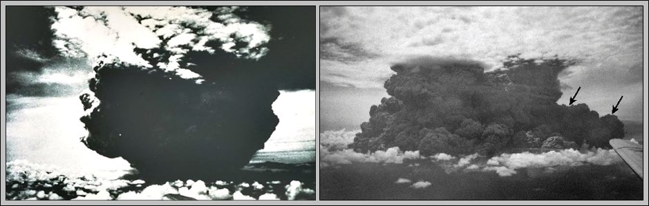
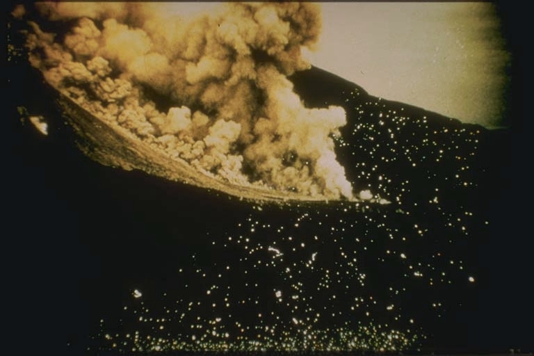
This dramatic photograph of the catastrophic eruption of January 21, 1951 was taken by the pilot of a commercial aircraft flying from Port Moresby to Rabaul. From about 40 km NW, the pilot observed this powerful eruption column, which rose to a height of about 13 km within two minutes. Shortly afterwards, the cloud expanded horizontally away from the volcano (arrows), as devastating pyroclastic flows and surges swept radially up to 12 km from the crater. (Photos by Capt. Jacobson, 1951, published in Taylor, 1958).
Just after 10.30 on Sunday morning of 21 January 1951 a paroxysmal explosion released a cloud of intense heat and massive force. The sound of the blast carried over 130 km and dust even reached Port Moresby, 300 km across the island. Within an area of 155 km², there was almost complete devastation by the pyroclastic density current (PDC) that accompanied the explosion. The town of Higaturu (some 10 km N of the volcano) was the District Headquarters of this remote region normally blanketed with dense rain forest. This town, missions, schools and 29 villages were swept by the lethal cloud, virtually blasted off the face of the earth. Further terror was caused by another strong eruption that night of the 21st at about 20:30, which was seen and described vividly by people still fleeing the area. This second vulcanian explosion is thought to have been still more violent than the first, but it did not produce an equally strong pyroclastic flow (PF).

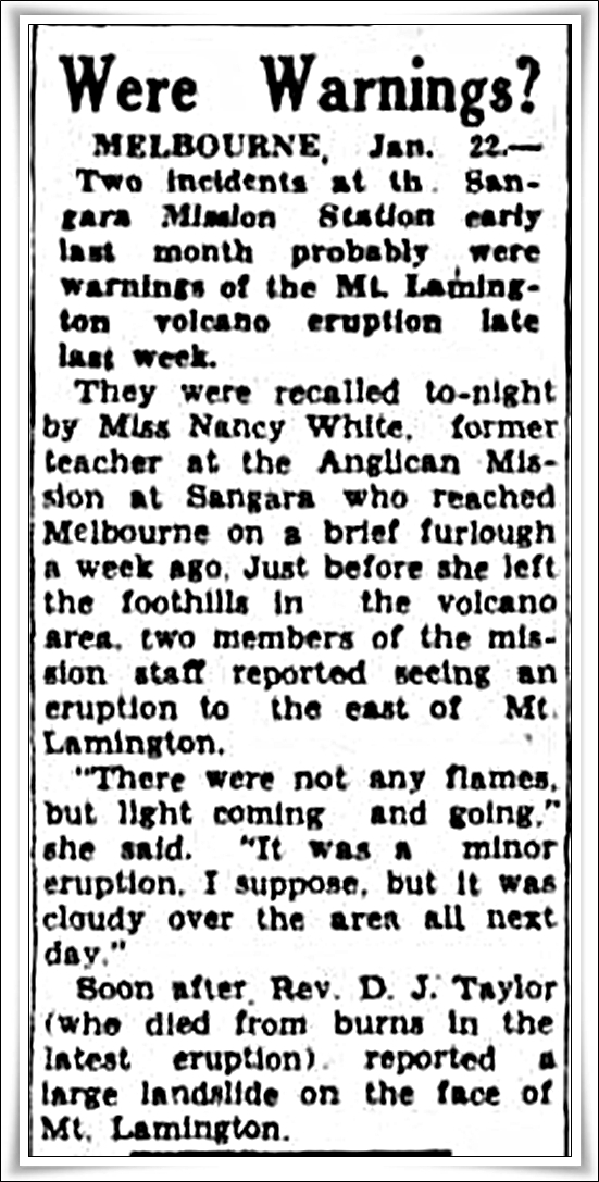
One of the first newspaper reports on the disaster: Queensland Times (Ipswich), Monday 22 Jan. 1951, page 1
![New Guinea, Mount Lamington volcano explosion, 1951: a native and his injured son are shaded by his daughter with an umberella as they come from their village Higatoura. Their mother and wife lost her life in the blast, many thousands of natives died in the blast [picture] / Ern McQuillan. Held in the National Library of Australia.](https://volcanohotspot.files.wordpress.com/2016/12/la09.jpg)
New Guinea, Mount Lamington volcano explosion, 1951: a native and his injured son are shaded by his daughter with an umbrella as they come from their village Higatoura. Their mother and wife lost her life in the blast, many thousands of natives died in the blast. [picture] / Ern McQuillan. Held in the National Library of Australia.
Long before news of the event had reached the outside world, a handful of survivors from the marginal settlements found their way into the dust-fogged area of devastation and began to evacuate the wounded. Dust and ash filled every stream and tank for some miles around, and there was urgent need of food, water and medical supplies. Rescue parties were hampered by suffocating pumice dust, sulphurous fumes and hot ashes on the ground, and the advance post of relief workers at Popondetta was threatened with destruction by other eruptions during the several days following. No one remained living in an area within 16 km of the crater during those first 24 hours. The death toll stood at 3 738*.
![Higataru hospital ruins, [1951], [picture] / Collection: Speer, Albert (1922-2014). Held in the National Library of Australia.](https://volcanohotspot.files.wordpress.com/2016/12/la08.jpg)
Higataru hospital ruins, [1951], [picture] / Collection: Speer, Albert (1922-2014). Held in the National Library of Australia.

With hindsight it became clear that the death of so many people could have been avoided – had there only been someone able to interpret the signs. Six days of precursory activity should have been sufficient to evacuate the place. Ms. de Bibra had gone on writing:
Queensland Times (Ipswich), Tuesday 23 Jan. 1951, page 1
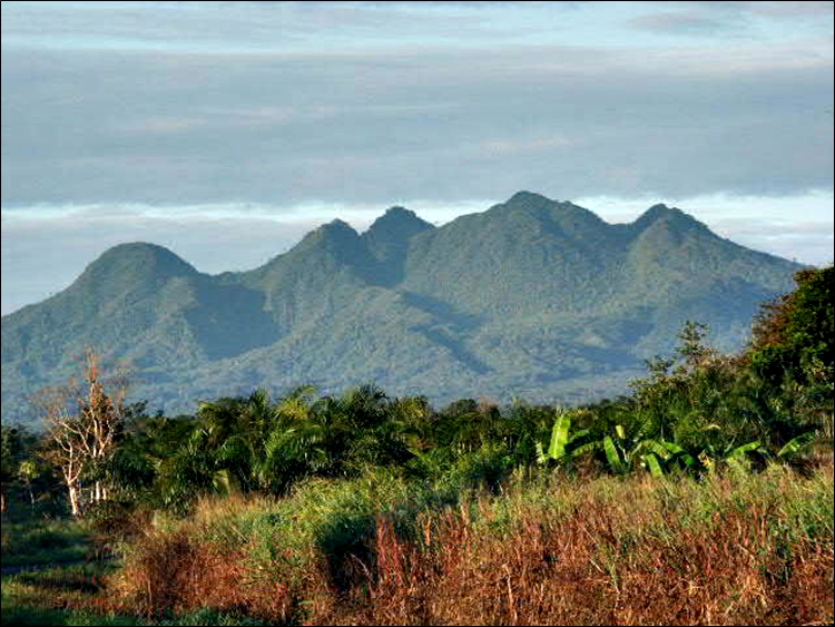
“Mt Lamington … lies behind us and consists of four or five sugar-loaf peaks … We have always loved her for her beauty and nearness … [but now] she has changed from fairy queen to a wicked witch, and the gossamer scarves of mist [seen in the early mornings] have turned into smoky outpourings of some bubbling cauldron … For days we had tremors … and the face of Lamington became scarred with great patches of bare earth, caused by landslides. Then one morning – January 18th [the previous Thursday] – after a night of continuous tremors, smoke appeared [that later] … came pouring out in great thick puffs high into the sky, wreathing and curling in awe-inspiring cauliflower shapes …” This citation, including remarks, is from the book “Fire Mountains of the Islands” by R.W. Johnson, where he also details the many sources that actually had called Mt. Lamington a volcano long before this eruption, like a survey by Australian geologists, or the writing of Dutch geologist R. W. van Bemmelen, who had even referred to Mount Lamington itself as being an active volcano.
But such remote knowledge just wasn’t at hand at the time. Yet… still…, wouldn’t have anyone drawn certain conclusions when landslides, continuous tremors, “smoke in great thick puffs high into the sky” happen in a mountain – in a country that is dotted with volcanoes right left and center? But no, in the opposite: the District Commissioner at Higaturu informed the authorities in Port Moresby of an outburst a few days earlier that “there was no need for alarm“. The people at an airstrip 25 km away could see an eruption cloud rising lazily from Lamington to the south-west, and the then acting Administrator, who had heard or seen a bit about another volcano, concluded that the volcanic pressure was being relieved quite safely and “there was no immediate danger to human life at Higaturu“. The decision was made not to evacuate the area – there were, however, spontaneous self-evacuations from some Orokaiva villages – and this decision turned out to be “a case where bad science was more dangerous than sound superstition”. The Administration’s volcanologist, Tony Taylor, was in Rabaul and at this time had not been consulted about either the volcanic eruptions or a need for any evacuation…

George Anthony Morgan Taylor GC, known as Tony Taylor
In 1952, the Australian volcanologist Tony Taylor (1917-1972) was awarded the George Cross for “conspicuous courage in the face of great danger” during the eruption of Mount Lamington in Papua from January to March 1951. Taylor was admired for his professional commitment and stoicism, and he surprised some colleagues when he would lie flat on his back on the ground to feel tremors or use a glass of water to watch tremor-induced ripples.
“He arrived at Mount Lamington on the day following the main eruption and from that day onwards, over a period of several months, he visited the crater by aircraft almost daily, and on many other occasions, on foot. On some occasions he stayed at the foot of the volcano throughout the night. During the whole of this period the volcano was never entirely quiet. Several eruptions took place without any warning or any indication from the seismographical data which he had collected. Without regard for his personal safety he entered the danger area again and again, each time at great risk, both in order to ensure the safety of the rescue and working parties and in order to obtain scientific information relating to this type of volcano, about which little was known. His work saved many lives for as a result of his investigations in the danger zone he was able, when necessary, to warn rehabilitation parties and ensure that they were prevented from entering an area which he so fearlessly entered himself.”
His 1958 eruption report is still called “the bible of the Lamington literature”, although newer research probably has led to some amendments. It is a fascinating read of 215 pages and one can learn a lot from it – the more sensitive should just avoid some graphic images and descriptions (chapter Destruction of Life on p. 86 and image p. 100)
*The number of victims varies from “almost 3000” to “4000” in different reports. Certain seems to be only that 35 of them were Europeans.
ABOUT THE MAIN ERUPTION
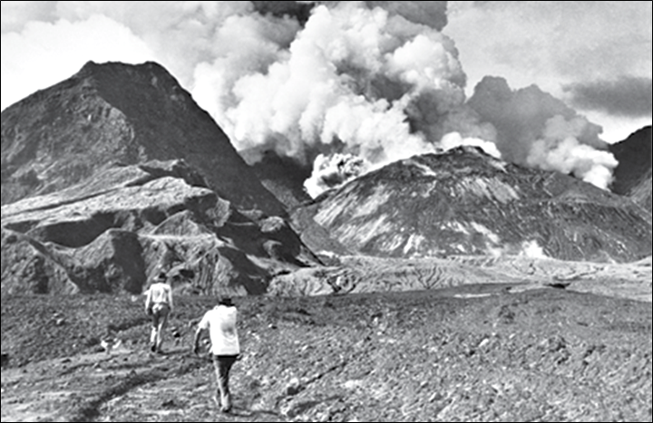
This slide, taken in 1951, shows a nuee ardente (PF) flowing down Lamington volcano. (Image: NOAA/NGDC, University of Colorado)
Paradoxically, it seems that the main eruption owed its great devastating power to a lack of intensity. Had the eruptive mechanism possessed the power to throw all its ejecta high into the air there would have been a relatively harmless fall of cooled ejecta over the surrounding country. Some of the explosions of this eruption did in fact behave in this way. For the most part, however, power was lacking and a great proportion of the material was discharged in such a way that little atmospheric cooling was possible. With this retention of heat, gas continued to be released from the lava, thus providing a lubricant which allowed the masses of fragmental lava to descend as swift and sometimes devastating pyroclastic flows (PF). The eruption did not develop a high, umbrella-type, plinian eruption column with a ‘stalk’, but rather had formed a huge broad vulcanian cloud. Much of the cloud’s great mass was unable to sustain its upwards momentum for longer than a few minutes. It collapsed, spreading outwards as a PF, especially down the northern flank of the volcano.
![Rock and ash flows 8 miles down stream, Amboga River, 1951 [picture] / Collection: Speer, Albert (1922-2014). Held in the National Library of Australia.](https://volcanohotspot.files.wordpress.com/2016/12/la06.jpg)
Rock and ash flows 8 miles down stream, Amboga River, 1951 [picture] / Collection: Speer, Albert (1922-2014). Held in the National Library of Australia.
THE FOLLOWING MONTHS AND YEARS
After the climactic explosions of 21st January, Mount Lamington remained quiet for three days. Then, on 25th Jan., explosive activity was resumed and during the next six weeks spasmodic outbursts occurred, some of them quite powerful as well. In less than three weeks after the main explosions a dome had been extruded 1,000 feet above the floor of the Lamington crater. This dome grew to a considerable volume and was destroyed in a violent explosion on 5 March 1951. (The chapter “The Dome”, p. 125 of T. Taylor’s report, is particularly interesting as it describes in detail how the dome came about from nothing. A dome doesn’t just slowly and almost imperceptibly “grow”, as I imagined, but heaves and presses its way out spasmodically.)

This eruption (5th March) propelled pieces of the dome 5x4x3.5 m in size as far as two miles from the crater. It poured a great portion of the dome onto the northern slopes, in a flow of pumice and rocks, for a distance of 14 km; the whole being so hot as to set fire to every tree in its path. Some of the mudflows of the past months had remained viscous and heavily laden well beyond Popondetta airstrip, some 25 km away. Temperatures of the PF from the main eruption were so high that the deposits were still hot two years later. The first week in March marked the end of the most powerful explosive phase.

Secondary activity became commonplace during the following weeks. After the March eruption it reached a high intensity; on many occasions widespread secondary explosions (caused by streams coming in contact with hot deposits) enveloped large areas of country with dust clouds and produced visibility conditions similar to those prevailing during a full-scale eruption. These were disturbing periods for those at the Observation Post, for the volcano was completely concealed and it was impossible to tell at the time if a crater eruption was actually in progress. At the same time the loud roar of mudflows descending the Ambogo (which was heard almost daily during the first half of 1951) often drowned all other sounds.
At the end of the 1951 eruptive period a lava dome partially filled the summit crater; the period of repeated lava dome building and collapse with mud- and pyroclastic flows continued from 1951 to 1956. The tallest dome grew to 580 m (1,900 ft) above the crater floor before it collapsed.
Aerial and ground inspections of the summit at Lamington in 1991 showed a dense canopy of vegetation with only a few scattered thermal areas. Temperatures from one of the larger thermal areas had dropped from 362°C in 1973 to 93°C by 1991. Based on the temperature decrease, the vegetation, and lack of volcanic seismicity, scientists reduced Lamington’s threat status and decreased surveillance.
THE VOLCANO
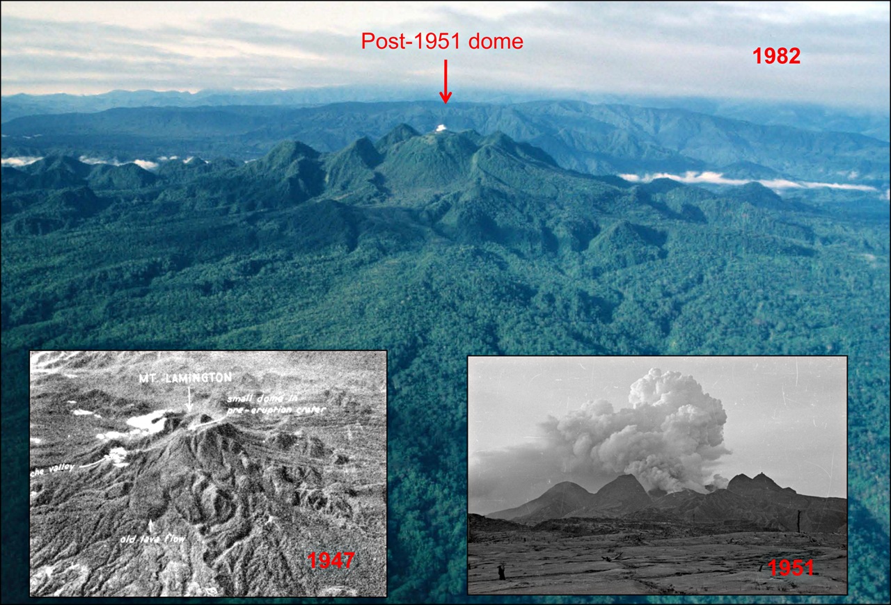
Aerial view of Mt. Lamington 1982 with two insets of 1947 and 1951. (Source: Belousov)
The dome-forming stratovolcano Mt. Lamington sits on the coastal plain north of the central Owen Stanley Range (or SW of Popondetta in the Oro Province), about 40 km inland from the coast; other dormant volcanic neighbors are Hydrographers Range and Mt. Victory. Mount Lamington has a characteristically discontinuous pattern of activity – long periods of dormancy lead to periodic paroxysmal eruptions. These have consisted of a discontinuous series of outbursts ending with effusion of viscous lava whose physical condition has been such that the formation of lava domes has been more common than that of lava flows.

The revival of volcanic activity apparently began east of Lamington where that complex volcanic pile, the Hydrographers Range, was built up. The volcanic cone of Lamington is formed amidst a semi-circle of peaks around the head of a broadly carved-out avalanche valley that drained north, toward the location of the former town of Higaturu. Those peaks around it are remnants of lava domes, some are now part of the present breached crater wall. Parasitic structures on the outer slopes, mostly on the western flanks, are ample evidence of intrusive activity over time. It appears that many of those are domes rather than cinder cones. The main cone itself consists mostly of unconsolidated tuffs and agglomerates. Much of the material has evidently been laid down rapidly in large unsorted masses by PFs or by mudflows. In the banks of the Ambogo river that drains the volcano, layers of old deposits can be found; further investigations of these show that eruptions of identical characteristics, perhaps even larger, must have taken place before the last one.
Lamington magma is an andesite, rich in volatiles; typically the lavas contain an abundance of hornblende and biotite and have unusually high levels of Nickel and Chromium. There are six different types of andesite found in the volcano’s rocks; those from the older crater walls are so-called shoshonites. Chemical analyses reveal similarities with the lavas of other volcanic areas which also have produced this type eruptions and lava domes: the Lesser Antilles, the Crater Lake area of Oregon, and especially certain volcanoes with domes of submarine origin such as Bogoslof in Alaska and Sanghie Islands, Indonesia.
SOME GEOLOGY

(a) Regional map of the Papuan Peninsula, surrounding basins, subduction zones (both active and inactive) and seafloor spreading centres; (b) simplified geological map of the Papuan Peninsula, indicating the position of Mt. Lamington and three other major volcanic edifices, the Papuan Ultramafic Belt (PUB), Owen Stanley Metamorphic Complex, Milne Terrane and Aure Fold Belt. (J. Zhang et al. 2015, after Davies, and Baldwin et al., 2012; Smith, 2013a)
 The island of New Guinea is part of the Australian Plate (Sahul) comprising mainland Australia, Tasmania, New Guinea, Seram, possibly Timor, and neighbouring islands. When sea levels were lower during the Pleistocene ice age, they were all connected by dry land but were separated when sea levels rose during the past 10,000 years.
Mt. Lamington is a Quaternary stratovolcano on the eastern “tail” of New Guinea in a tectonically complex boundary region. This peninsula lies on the NNE-moving Australian Plate (which is actively subducting beneath the W-moving Pacific Plate at the New Britain Arc and the Solomon Arc). To the east of the peninsula, seafloor spreading creates the Woodlark Sea Basin, and has been propagating westward, probably resulting from slab pull owing to the subduction of the Solomon Sea Plate. To the north of the peninsula, the Trobriand Trough is the trench of a south-dipping subduction zone.
However, the absence of a seismically defined Benioff Zone suggests that subduction in this area is presently inactive, although it might have been active in the Miocene. Chemical analyses of the magmas indicate that, although there is apparently no active subduction in the region, magma generation is primarily still driven by subduction-related processes. It is thought to be a product of delayed partial melting of subduction-modified mantle, in relation with the westward propagation of the Woodlark Spreading-Rifting System.
Although tectonic earthquakes are not numerous in the eastern region of Papua, Taylor thought that the broad picture of events in the adjacent island regions suggested that the Mount Lamington eruption was triggered by a crustal stress pulse. This seemed to be evident in an increase in frequency of tectonic earthquakes and reactivation of volcanic centres in New Guinea, the Solomon Islands, and the New Hebrides at the time.
~~~
I would like to finish with another citation from R.W. Johnson’s book: “Many Australians owed their lives to indigenous Papuan stretcher-bearers, an issue dealt with in a poem, reflecting contemporary racial politics, written in 1942 by an Australian sapper on the Kokoda Trail:
‘Slow and careful in bad places/On that awful mountain track/And the look upon their faces/Made us think that Christ was black’ wrote Bert Beros in The Fuzzy-Wuzzy Angels.“
~~~
Disclaimer: I am not a scientist, all information in this (and any of my other posts) is gleaned from the www and/or from books I have read, so hopefully from people who do get things right!🙂 If you find something not quite right, or if you can add some more interesting stuff, please leave a comment.
Enjoy! – GRANYIA
SOURCES & FURTHER READING
– Fire Mountains of the Islands, -8- (Johnson, Book, 2013, online)*
– The 1951 eruption of Mount Lamington (Taylor, 1958, PDF)*
– In the shoes of Tony Taylor: results of reinvestigation of the 1951[…] (2011, PDF)
– Abstract (text) to the above presentation (2011, PDF)
– GVP, Lamington
– Wikipedia, Mt. Lamington (German)
– HVO, Volcano Watch weekly, 09/25/2008
– Magmatic Enclaves and Andesitic Lavas from Mt. Lamington, […] (2015)
– Retrospective: My Grandfather Ivan Champion (Blog)
– Collection of slides of the aftermath and relief effort following the Mt. Lamington eruption, Papua New Guinea, 1951
*Contains graphic images and/or descriptions!


A great way to finish the year, Thank you Granyia ! Very interesting, you picked up the right place. I’ll read the report from Taylor.
LikeLike
I instantly thought of Montserrat while reading this.
LikeLike
Actually, my immediate thought was of El Chichon in Mexico, which followed a similar pattern -and unfortunately with similar catastrophic results – although without (yet) producing a dome.
LikeLike
Happy New Year to everybody, and this is NOT an erupting volcano:
https://twitter.com/Wyatt_Boerp/status/815195221621358592
LikeLike
I’ve seen that. It is a hoot. Very good demonstration of something an old aero prof of mine said 45 years ago: If you have enough thrust, you can fly a barn door. They had enough thrusties. Really appreciated they used long poles to light it off. Impressed the parachute worked while the wheel was tumbling. Cheers –
LikeLike
Bogoslof a few hours ago: “Seismic data from nearby islands detected a volcanic signal from Bogoslof volcano starting at 21:18 AKST today (6:18 UTC Jan 4) lasting ~5 minutes and a series of lightning strikes were identified by the World Wide Lightning Location Network. An eruption cloud as high as 33,000 ft has been detected in satellite data. AVO is therefore raising the Aviation Color Code for Bogoslof to RED and Volcano Alert Level to Warning.”
I wish there was a webcam on the main islands pointing in that direction, over-10km clouds should be visible from far.
LikeLike
Hi dfm, have fun with your raspishake! Where are you going to use it, at home and anytime, or are you going somewhere more seismically active? Let us know how it goes, will you? I don’t know about the technical side of it but it’s fascinating anyway!
LikeLike
New research involving controlled explosions in a granite-dominated setting: What was that rumble? As seismic instruments become available for broader use globally, the question arises how to distinguish with certainty between the signatures of an earthquake and an underground explosion.
LikeLike
AVO have a busy time lowering and raising alert levels for Bogoslof. Having gone down to Orange at 11:47 AM AKST today they had to raise to Red again two hours later for indications of a “significant explosion”.
LikeLike
Explosion in Nev. de Chillan looks mighty black but they say it was of low energy
LikeLike
They also lowered the alert level for Hudson back to green and mention a magnitude 3 quake in Descabezado Grande, only historical eruption followed the massive Cerro Azul eruption in 1932.
LikeLike
Interesting, there have been a few more EQs in Descabezado in recent months, if I remember right.
LikeLike
Also recorded today was a shallow M3 directly below Mt. Teide/Tenerife.
LikeLike
Hawaii: On December 31, nearly all of the 26-acre lava delta suddenly fell into the sea, along with more than four acres of older coastal cliff area, which included the former lava viewing site. This is an 11 minute live recording of a very interesting presentation of the lava delta collapse on new year’s eve at the Kamokuna ocean entry by Tina Neal, Scientist-in-Charge of the HVO.
LikeLike
Lavaflows are built upon a base of unstable rubble, just like with Surtsey. I think that the unstable rubble is the root cause of Surtsey being heavily eroded by the waves of the North Atlantic.
LikeLike
Cayambe (Ecuador) continues to have anomalous seismic activity with many VT and some LP quakes (2-8km deep), flank deformation, persistent and strong smell of sulfur on the slopes and new cracks in the glacier near the top of the volcano. Due to the type of recorded EQs and their locations it is thought that the signs are of magmatic origin. A medium-term eruption (weeks to months) is possible but rather unlikely if there are no sudden changes. Cayambe has last erupted in 1785, but recent studies using tephrochronology have determined numerous eruptions in the last ~2000 years.
In an overflight on 28/12/2016 no external activity could be seen, except for the glacier cracks that had been reported by climbers (IGEPN)
LikeLike
New post is up! 🙂
LikeLike