
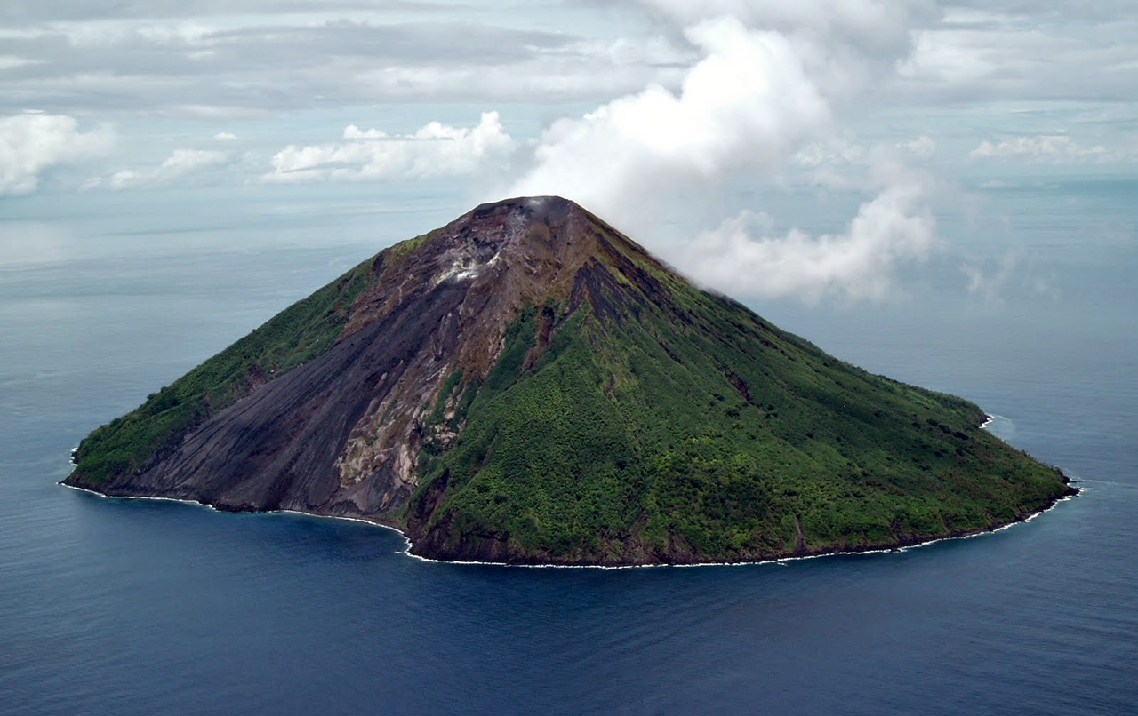
Tinakula volcano. (© Lance McC, date unknown but before 12/2009, via Panoramio)
Tinakula volcano of the Solomon Islands in the South Pacific ocean started an eruption on 21 October 2017. Whether or not the volcano is still erupting is everybody’s guess as no more official reports were issued after the 6th of November and satellite imagery is inconclusive. Update 17/11: GVP has just listed the eruption as lasting from 21 – 26 Oct. 2017, classified as a VEI=3. However, the reports have stated still ongoing explosions on Nov. 6, so, I expect there might be amendments later.
Tinakula is a barely known, rarely visited and never monitored small volcanic island some 25 km north of Nendö Island. It has a diameter of just 3.5 km at its widest and is located in the Santa Cruz Islands, which comprise the eastern end of the Solomon Islands. Tinakula is one of a handful active volcanoes and seamounts in the country; others like Savo and Simbo/Patukio may have erupted during the last centuries but no written records seem to exist. More widely known is Kavachi, a frequently and sometimes spectacularly erupting submarine volcano.

Map of the Santa Cruz Islands (Wikipedia)
ERUPTION ON 21 OCTOBER

Tinakula may have been degassing for weeks before the onset of eruption; some Sentinel 2 images show what looks like quite strong steam plumes. (25/08/2017)
Possibly the volcano has been announcing its renewed activity for weeks in advance with possible strong steam plumes (but then, you never can be sure with mountain top clouds until you see them moving).
While the initial of the first two explosions produced an ash plume of 4.6 km hight, the second column of ash and gas reached a height of 10.7 km. The Himawari images below show a shockwave was clearly visible after the second blast – look at the clouds around the volcano. Later that day ash plumes rose up to 6.1 km.
Himawari-8 loop from October 21, showing the first two blasts from Tinakula in the Solomon Islands. (© Meteorological Service of New Zealand):

Significant SO2 emission from the first two explosions at Tinakula volcano on Oct 21, with SO2 detected by multiple satellites (est. mass ~40 kilotons SO2). (Via Simon Carn, @simoncarn on Twitter)
Authorities class Tinakula’s eruption as “Category Three”, which means a “minor” eruption. Tinakula Island is uninhabited; having said that, it was stated in the first news reports that three people had been rescued from the island who were “looking after their pigs”* there.
The main risk from eruptions is the ash which is carried over to nearby islands by the trade winds.The dominant SE trade winds blow ash and gases away from inhabited islands for most of the year, but an ashy eruption occurring in westerly winds may affect populations in the Reef Islands. Volcanic bombs of 5 cm in diameter from an earlier eruption were seen in villages on the Reef Islands (over 50 km to the E). They were reported by the locals to have fallen from the sky.

Panoramic image of Tinakula showing its varied landscapes from fresh black ash fields on the left, bare rock slopes in the center, and lush verdant growth on the right. (© Ken Marks, via Khaled bin Sultan Living Oceans Foundation website)
*I hope those pigs are (and stay) well fenced in… the Rainforest Trust writes on their website about a Biodiversity Reserve project: “On Tinakula, the main threat [to endemic species] is the possible introduction of invasive species. Currently no cats, rats or wild pigs exist on the island, miraculously making it the only predator-free island in the Solomon Islands. It is urgent that Tinakula be protected as soon as possible to maintain its unique status, as the introduction of any invasive species could have a devastating impact on the island’s populations of threatened wildlife.”
SO REMOTE…

Tinakula 22/10/2017 (via facebook: Gamara Okzman Bencarson)
While international news and social media reported on the eruption within one day (21/22 Oct.), the local “Island Sun” wrote on 23 Oct. “As of yesterday, information the Island Sun received from Met was that Tinakula volcano’s situation gives no sign for eruption, or any serious outlook for eruption“.
On the 24th, RadioNZ’s report stated there were no seismographs on Tinakula, nor had there been an aerial assessment of the eruption which made it very difficult to monitor its volcanic activity.

First observation visit! Tinakula 22/10/2017 (via facebook: Gamara Okzman Bencarson)

Left: Ash column from the Tinakula eruption reaching Nendö Island. (23/10/2017, via EOSDIS worldview) Right: Glowing lava flow down the NW landslide scar captured in Sentinel 2 image from 24/10/2017.
The following days National Situation Reports came around; they always emphasized how very small and unimportant this eruption is/was: “…affected by Tinakula mini-eruption…” and “…following the minor eruption of Tinakula volcano on Saturday 21st October 2017…“. This might be true in the geological sense – but there is no downplaying the severity of ongoing ash fall for a remote reef island population who depend solely on rain water collected off their roofs and bins for all of their needs. There were reports from the most affected Reef Islands that people only have a few days worth of fresh water and coconuts to survive on. Given that air craft couldn’t fly there because of ash, and boats take days to reach the islands, this can be quite a precarious situation for them.

Water flooding in! 😉 Report from 30/10/2017: Water relief of 11 790 units of bottled water, food relief and medical supplies are being delivered to affected islands. Also, a geological team is going to make an assessment of Tinakula’s situation. (Img.: Island Sun)
Additionally, people being in the dark about what to expect from the volcano will always lead to fear, especially if they come across the usual hype stirred up by international tabloids. A teacher in one of the affected villages said that the shortage of safe drinking water was one problem, but the lack of accurate information was also an issue. Residents were worried – what will happen next besides the water problem? They asked many questions, and also started speculating and wondering about things like what about the sulphur, will there be acid rain? One resident wrote on fb: “This is what happened to us. Late Friday night Tinakula volcano erupted.. Temotu province settlers are in trouble due to the dust covering every houses and plants.. We did not drink from our tank waters because of water contamination..”
So far there have been very few days cloud-and-steam-free enough for satellite images to capture the ongoing activity of Tinakula. In one, though, a clear moment revealed the northwestern part of the island. Compared with an earlier image, it can be seen that a new embayment of lava and/or tephra had been built up during the previous three days

Satellite image from Oct. 22, 2017 of Tinakula volcano. Ashfall covers the island; a new pyroclastic delta has formed on the NW coast. Green dashed line shows the pre-eruption coast line on Sept. 9, 2017. (© Planet Labs, annotation by author)
The National Situation Reports by the NDMO are not providing any detail beyond the eruption being “tiny” but thankfully some pictures – geologists spent about a week there, setting up a temporary seismograph and analysing rain water contamination on the neighboring islands.

The Situation Report 04 (Nov. 3, 2017) stated that Geology officers had landed on Tinakula on Nov. 1. They had set up volcano monitoring equipment and taken an acidity test on the rain water, result: pH=5.11, meaning not contaminated.

The Situation Report No. 05 (Nov. 06, 2017) states that the volcanic assessment on Tinakula showed numerous eruptions and tremors.
The geologists left on the 7th of November. This island is so remote that the exiting news of an eruption may come through within a few days, but we will probably never learn when, how, or if at all the eruption has ended.
SOME GEOLOGY

Tectonic Elements of the SW Pacific. The Solomon block contains the Solomon Island archipelago, which is bounded to the north by the Vitiaz (north Solomon) trench and to the south by the New Britain-San Cristobal (South Solomon) trenches respectively. The Solomon arc is part of the much larger Greater Melanesian arc which includes the islands of New Britain, Santa Cruz, and Vanuatu. (from Petterson et al, Makira Geol. Map)
 Though politically they are part of the Solomon Islands, geologically The S. Cruz Is. belong to the Vanuatu arc system. In this complex section, the San Christobal Trench (also called Solomon Trench, to the west) is linked to the New Hebrides Trench (or Vanuatu Trench, to the south), forming a “knee”. Thus Tinakula volcano lies directly in that “knee”, and on the same submarine ridge as the volcanoes of Vanuatu. To the N the area is bordered by the Vityas Trench system, the boundary to the Pacific plate. There have been several reversals in tectonic history as to which plate is subducting. Presently the Pacific plate is overriding the Australian plate.
Due to its active tectonics this region is particularly prone to strong earthquakes. On February 6th, 2013, a deadly and destructive M 8.0 earthquake occurred in the Santa Cruz Islands. It was the result of shallow thrust faulting on or near the plate boundary. One of the numerous aftershocks of M 7 struck ~9 km from Tinakula; over 100 tsunami run-ups went 500 m inland and inflicted further damage on nearby reef islands.

A tsunami following the M 8 earthquake 2013 has been (and still is) reported widely as rushing in with only 1.8 m high waves. Yet, the event damaged more than 1,060 homes and affected more than 4,500 people. It cleared out dense jungle forests and moved boulders. A later assessment showed that in fact the waves were much higher, namely perhaps over 12 m high. Because of an “indigenous knowledge” of earthquakes and tsunamis, the people of Santa Cruz Island did not wait for a government warning before evacuating and running to high ground. Thus the number of victims could be limited. (© Hermann Fritz, via blogs.agu.org/geospace)
Tinakula seems not to be the only volcano in the area. Mapping of the ocean floor between Makira (to the W) and Santa Cruz Islands showed that there are numerous volcanic edifices oriented along three linear to arc-shaped chains. It is thought that the northern chain relates to subduction of the Australian Plate, the southern one relates to former southward subduction of the Pacific Plate and the central one relates to rifting.
THE VOLCANO

Tinakula with lava flows, before 2014. (© UltraPanavision, via Flickr)
Tinakula is a frequently active volcano. There are many photos on the internet, taken by passing travellers from their boats or cruise ships, showing a thick white plume or even ash clouds. This dominantly andesitic stratovolcano has a breached summit crater that extends from the 851-m-high summit to below sea level. Landslides enlarged this scarp in 1965, creating an embayment on the NW coast. A satellitic cone named Mendana is located on the SE side.

Detail of Tinakula’s steamy summit crater with fumaroles hinting at forces active below the surface. (© Ken Marks, via Khaled bin Sultan Living Oceans Foundation website)
Numerous historical eruptions of Tinakula are listed in the GVP, beginning in 1595 and up to 2012. They were mainly small, with occasional moderate ones (VEI 3) in between. In about 1840, an explosive eruption apparently produced pyroclastic flows that swept all sides of the island, killing all inhabitants.
Frequent historical eruptions have originated from a cone constructed within the large breached crater. These have left the upper flanks of the volcano and the steep apron of lava flows and volcaniclastic debris within the breach unvegetated. In the 20th c. eruptions lasted from several months to a year; the last one though started in 2008 and ended in 2012.

The steep loose ash/cinder slope from a recent eruption terminates in a narrow black sand beach. (© Ken Marks, via Khaled bin Sultan Living Oceans Foundation website)

4/2002: View of Tinakula showing the landslide scarp and embayment on the NW coast, with hot cinders rolling down the slope. The scientists from the RV Franklin heard a roaring noise from Tinakula’s active crater when the boat was 50 m offshore. (© Donn Tolia, GSSI, and CSIRO)
Eyewitnesses flying over the 1971 eruption described the lava as pouring out of a 3-m-wide crack about 400 m up the W wall of the cirque caused by the slope failure. A strong odour of H2S could be smelled in the plane at heights of between 0.6 and 0.8 km. The sea was discolored for a distance of 500 m offshore and it was bubbling violently 25-30 m from the cliff edge where the lava entered the sea. A later report says that the single lava flow from the fissure had been joined by another lava stream flowing from the crater being 50-100 yards wide. In that eruption lava poured down the western side and into the sea for two months.

The landscape below the area of the most recent eruption is quite barren. Corals have not yet begun to colonize the boulders and there is very little life evident in this otherworldly scene of monotone black. (© Ken Marks, via Khaled bin Sultan Living Oceans Foundation website)
That there also has been much volcanic activity on the sea bed around Tinakula is shown by a survey of the submarine parts of the volcano in 2014. Here’s from the paper’s abstract:
SMS (seafloor massive sulfide) mineralization deposits have been discovered in association with a row of scoria cones. The structural setting involves a strong rift fabric, reflecting north-south extension, and a series of horsts and grabens. A large fissure, extending over 5 km along a WNW-trending structure hosts numerous monogenetic scoria cones and maars, which are similar to those in terrestrial environments.
Mineralization is widely distributed as hydrothermal mounds and chimneys along the flanks and tops of the scoria cones, as well as within the craters of the cones and maars, for a strike length of more than 1200 m.

Hot, buoyant, mineral-laden fluids rise from deep within ocean crust and mix with cold seawater. That triggers the precipitation of minerals that form deposits near and on the seafloor. Precipitating minerals also form seafloor “chimneys,” and mineral particles in the fluids venting at the seafloor make the fluids look like smoke. This is an example from the Manus I. area, PNG, 2006. (© Maurice Tivey, WHOI)
The volcanic facies relationships suggest that phreatomagmatic eruptions created a number of discrete maar volcanoes consisting mainly of country rock with lesser juvenile clasts. Subsequent strombolian eruptions built up the scoria cones with variable proportions and sizes of volcanic clasts. A change in eruption style from explosive to effusive is indicated by the presence of autobrecciated** lava flows on the flanks of several of the cones. The hydrovolcanic fragments of the scoria phase quickly cooled in the water, with the precipitation of numerous secondary minerals that filled the pore spaces and cemented the breccias. The entire volcaniclastic sequence was then argillically altered and infilled by anhydrite. These processes reduced the permeability of the volcanic substrate, allowing the hydrothermal fluids to become focused and vent to the seafloor.

Autobreccia. From Earthly Musings
**Autobrecciation occurs when cooled down lava breaks up into blocks and these blocks are then reincorporated into the lava flow again and mixed in with the remaining liquid magma. The resulting breccia is uniform in rock type and chemical composition. (Wikipedia)
BESIDES: A RACE TO THE BOTTOM OF THE SEA

“The Deep Sea Minerals Project is a collaboration between the Pacific Community (SPC) and the European Union (EU). Initiated in 2011, the €4.4 million DSM Project is helping Pacific Island countries to improve the governance and management of their deep-sea minerals resources in accordance with international law, with particular attention to the protection of the marine environment and securing equitable financial arrangements for Pacific Island countries and their people.”
Such sea floor explorations are now underway in many parts of world’s oceans – commissioned by the mining industry. As since the 1960s marine mining has begun in shallower waters, development of new seabed mining technologies now aims at deep-sea mining. Those plans alarm many scientists. The mining is targeted at hydrothermal vents, where chemical-rich fluids from the seafloor spur the accumulation of not only metals, but also lush communities of exotic life. Ever since deep-sea vents were first discovered in 1977, they have yielded a treasure trove of scientific clues about how our planet’s surface formed, how the oceans’ chemistry works, even how life may have started on Earth. What if a gold rush into these unique ecosystems were to produce a sub-sea version of the environmental damage that mining has caused on land? Maybe that’s not something most of us have ever pondered. I have put the links to two thought-provoking articles in our further reading list below.

Tinakula seen from Lata town, Nendö Island (author and date unknown, before 8/2016; via daisi.com.au)
~~~
Disclaimer: I am not a scientist, all information in this (and any of my other posts) is gleaned from the www and/or from books I have read, so hopefully from people who do get things right! 🙂 If you find something not quite right, or if you can add some more interesting stuff, please leave a comment.
Enjoy! – GRANYIA
SOURCES & FURTHER READING
– GVP, Tinakula
– Nat’l Disaster Management Reports (NDMO)
– Seismic Activity in Solomon Islands
– Geol.–tect. framework of Solomon Islands (1998, paywalled)
– Relationship Volcanic Island Genesis & Indo-Australian Pacific Plate Margins. Eastern Outer Islands, Solomon Islands, South-West Pacific (1978, PDF)
– SMS along a submarine scoria cone row at the Tinakula Deposit (2015)
– On South Pacific seafloor mining (article, 2016)
– Promise and Perils of Seafloor Mining (article, 2016)
– Present-day crustal motion in the Solomon Is. (1998, PDF)
– 1st Geological Map of Makira (paper, PDF)
– Brian Taylor’s photos (antsofafrica.org)
– Who’s up for a Dive on an Active Volcano? (article, 2014)
– Island Sun (news)


That must have been a very loud bang on the neighbouring islands. Amazing shockwave. My sister sailed up through the Solomons a couple of decades years ago. They come to one village that looked like it had never seen western civilisation.. all reed huts and grass skirts, When they landed the local kids started questioning them about Kissinger’s chance of success negotiating the SALT I treaty. For all their remoteness they were totally up with the play, largely thanks to Australian correspondence school and the BBC world service. An awesome bit of the world.
LikeLike
Update 17/11: GVP has just listed the Tinakula eruption as lasting from 21 – 26 Oct. 2017, classified as a VEI=3. However, the official reports have stated still ongoing explosions on Nov. 6, so, perhaps there will be amendments later.
LikeLike
Visually, the volcano almost defines the stereotypical island volcano seen in movies, animation, drawings, cartoons, etc. Very cool. Cheers –
LikeLiked by 1 person
PhysOrg article this morning about the impact on subducted clay (kalonite) in decreasing melting temperatures of mantle which in turn creates magma. Kalonite has a bunch of water in it which evolves out as the plate subducts. The water in turn decreases melting temperature of surrounding mantle, creating magma which finds its way to the surface. Cheers –
https://phys.org/news/2017-11-clay-mineral-earth-mantle.html
LikeLike
Small phreatic eruption today in G. Agung, Bali. The eruption was initiated by a low-frequency tremor. A medium pressure plume of thick gray color rose about 700 m above peak (https://magma.vsi.esdm.go.id/press/view.php?id=111). LF tremor on the seismogram and ash emissions were observed for several hours afterwards.
LF tremor on the seismogram and ash emissions were observed for several hours afterwards.
LikeLike
G. Agung had another blast today, 25/11/2017, 17:30 WIB. Ash column up to 1,500 m (from the crater). Still Lvl. 3 alert. Some flights diverted, but Bali airport still open. Ash emissions are continuing, also some incandescence could be seen at the Bukit Asah webcam a few minutes ago. No panic among people, but many have resumed self-evacuation.
YT video by I Nyoman Yudana
LikeLike
LikeLike
This morning, Bali woke up to some more energetic eruptions. #Agung Aviation Code has been raised to Red. Last ash column reached 6142 m a.s.l. (ca 3000 m above crater). Volcano alert level unchanged at 3 (Siaga, or orange).
LikeLike
27/11/2017, 06:00 WITA: Alert status for G. Agung has been raised to level 4 (AWAS, RED). Danger zone: radius of 8 km from the crater and a sectoral expansion to the North-Northeast and Southeast-South-Southwest of 10 km from the crater. People within the danger zone are urged to immediately evacuate. Bali Int’l. airport in Denpasar closed from 27/11/2017, 07:00 up to 28/11/2017, 07:00, or according to further evaluation.
It has been found that the eruption is now of a magmatic nature. Ash is emitted continously to hights of 2,000-3,400 meters from the peak, with ash puffs sometimes accompanied by explosion sounds heard up to 12 km away. At night a strong glow can be seen from the crater. Non continuous harmonic tremor was recorded w/ amplitudes of 1-10 mm (dominant 1-2 mm).
LikeLike
Image: MAGMA Indonesia:

Report: https://magma.vsi.esdm.go.id/press/view.php?id=115
LikeLike
First lahars coming down from Mt. Agung. Close-up video – what a disgusting stuff, worse than porridge, yuk, igittigitt!
LikeLike
wow, I’m surprised that so much ash has already fallen to generate lahars as this must have been taken yesterday before it ramped up into a steady eruption.
LikeLike
Yes, the output of ash must have been a stupefying amount, imagine – a constant, 2000 m high, strong ash emmission for 24 hours, which brings a lot of water with it alone. Add the rain from the thunderstorms… One person tweeted, that it must be the worst rain he has ever experienced on Bali (not a native, but has been living there for many years).
LikeLike
https://twitter.com/WeatherSarov/status/935098714913431554
LikeLike
Pingback: TINAKULA 🇸🇧 – New Photos & Update |
Pingback: Volcanoes of the Solomon Islands – Part 1 of 2 |
Pingback: Volcanoes of the Solomon Islands – Part 2 of 2 |