

Giant’s Causeway World Heritage Site: Stacked lava layers cooled as basalt columns in the bay called Port Reostan. 2007. (© Petra Watzka)
Our readers in Indonesia or Chile might find it amusing when we Europeans get excited about any old volcanic plug in Germany or an ancient layer of basalt in Ireland but, hey, it’s Geology, it’s Volcanology, it’s the history of our country! So, let’s have a look at the volcanoes once active in Northern Ireland, you might be living there and not have known about some of them!
Some 600 million years ago the little chunk of Earth’s crust that is now Ireland moved with the tectonic plates across the planet’s surface. The uplands of the Sperrins and north-east Antrim in modern Northern Ireland are the remains of an ancient mountain chain, once larger and higher than the Himalayas are today. Formed from sediments laid down in basins on the American side of a long disappeared ocean known as the Iapetus, they show that not only did part of Ireland once form part of that continent, but also that tremendous collisions have occurred, producing metamorphosed rocks (mainly schists) out of materials formed on ocean floors.
WHAT’S BELOW THE TOP?

Ireland within the Pangea Super-Continent 😉 Click HERE to see large version, then try to find Ireland: Find Greenland – go E, find Norway – go S, find U.K. – go W; voila!
Up to the Cretaceous period (145-65 million years ago), this piece of crust had gone through various periods of hot arid or hot humid climates, it has seen the ancient seas flooding it and drying up again, leaving soft sediments like sands and clays on top of the schists. The Cretaceous brought with it raised sea levels again, and the return of deeper marine conditions; shells and the remains of dead microscopic marine plants were deposited on the sea bed, which over time led to the formation of a thick layer of chalk and limestone.
By the end of the Cretaceous, a land mass broadly recognisable as Ireland had continued its northward movement to a position similar to southern France today. Weathering of the limestone surface created a karst landscape with sinkholes and caves present. These features are visible today at the top of it. Not so, however, in most of the county Antrim and parts of adjacent counties – here the limestone layers have been ruptured by cataclysmic explosions and topped by massive lava flows and ignimbrites when they became part of the North Atlantic Igneous Province.
The North Atlantic Igneous Province
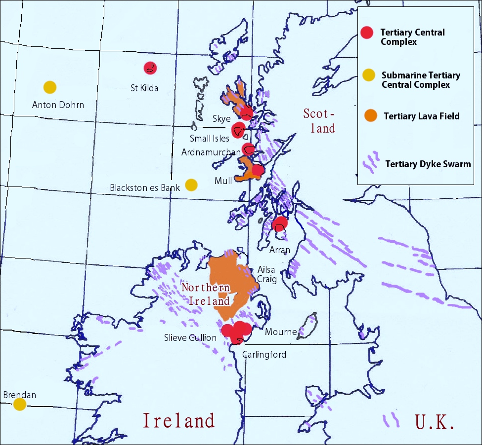
Map showing UK and Ireland withe the location of British Tertiary; central complexes, submarine central complexes, dyke swarms, lava fields. (derived from Wikipedia image ©Hazel Muzzy)
The North Atlantic Igneous Province (NAIP for short) is a large area formed by volcanic activity, centered on Iceland. At one stage, at the beginning of the Paleogene (or lower Tertiary), a large basaltic lava plain developed within the NAIP, called the Thulean Plateau. This plateau was broken up during the opening of the Atlantic Ocean, leaving behind such remnants as bits of northwestern Scotland, the Faroe Islands, bits of northwestern Iceland, eastern Greenland and western Norway and many of the islands located in the north-eastern portion of the North Atlantic ocean. A bigger chunk of what was left was located in the north-east of the island of Ireland, geologists call it the Antrim Plateau.
THE ANTRIM PLATEAU

(From Blog Ireland.RU)
The basaltic rocks of the Antrim Plateau are related to large-scale massive volcanic fissure eruptions and lava flows. This volcanic activity accompanied the opening of the north Atlantic Ocean around 50-60 million years ago, a process still going on. Extensive cracks opened up in the earth’s crust resembling those seen in Iceland or Hawaii today, allowing basaltic lava to pour out on top of the chalk. The total area of these flows is now much reduced compared to their original extent, but still, at 3,800km² they are Europe’s most extensive lava field.

The striking contrast: Black and White cliffs at Galboly, Antrim Coast Road. This is probably the most spectacular part of the coast road. The 80 million year old Chalk is overlain by 60 million year old basalt lava flows. (© Mike Simms, via Wikipedia)

Laterite horizon in the cliffs above the Giant’s causeway, formed by intense weathering of the top of a lava flow before the next eruption. 2013. (© Chris Rowan, on Highly Allochtonous blog)
The lavas of the Antrim Lava Group are divided into three main phases of activity: the lower, middle and upper basalts, separated by two extended periods of quiescence. During those intervening periods the upper surfaces of the preceding flows were exposed to hot and humid climatic conditions that deteriorated the rock to a depth of several metres. This, altered by weathering, produced two distinct red coloured layers of a palaeosol (ancient soil) known as laterite.

The headland on the right, known as Bendoo, is a black igneous intrusion (or a volcanic plug) and the white stack on the left is composed of metamorphosed Ballintoy Chalk. (© Eric Jones)
This widespread volcanic activity was accompanied and followed by frequent shifts in the relative levels of the land. Faulting, often reactivating much older crustal weaknesses, has produced a range of features. Large scale faulting over the central area of Northern Ireland resulted in a basin, now occupied by the lake Lough Neagh. Elsewhere, faulting has often brought rocks of different ages to similar levels so that cliff scenery on the north coast shows dramatic lateral transitions from basalt to chalk.
Some VOLCANIC FEATURES still there to be seen
Giant’s Causeway

Cliffs near Port na Spaniagh. Both Lower and Middle Basalts and the layer of palaeosol in between are distinguishable. The characteristic brick-red colour of the tropical laterite layer is caused by oxidation of iron within the basalt. (© and source)
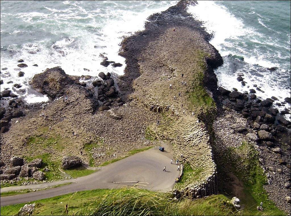
Giant’s Causeway seen from the cliff top. Unfortunately, much of the “protected” area has been destroyed by the infrastructure constructed to carry half a million tourists every year by busses directly to the site. 2007. (© Petra Watzka)

Giant’s Causeway, ~40000 polygonal basalt columns dramatically varying in size from a few centimeters to several meters high. 2007. (© Petra Watzka)
Giant’s Causeway is a World Heritage Site by UNESCO in recognition of its outstanding geology and exceptional natural beauty. The Causeway is made up of tens of thousands of basalt columns that together are referred to as the Causeway Tholeiite Member. These columns are preserved within lava flows that flooded a valley which had become blocked – the result was a lava lake that cooled gradually but evenly. As the lava cooled it contracted, cracked, and formed the regular shapes that we see today. The majority of the columns are five-, six- or seven-sided with a few four- and eight-sided pillars among them.

Ideal flow cooling and column formation in cross-section. (© and source)
These cracks propagate upwards and downwards, perpendicular to the cooling fronts, at roughly equal speeds. In an ideal situation, they would eventually join each other at the centre of the flow, creating continuous columns separated by slightly offset cracks at the centre. In the Lower Basalts one can sometimes see lumpy features that resemble pillow basalt: the so-called Onion Skin Rocks come from weathering of cracked basalts from the outside inwards which leaves those rounded “cores”.

“Onion Skin Rocks” at Giant’s Causeway. (© and source)

Giant’s Causeway by Dublin artist Susanna Drury, 1739.

Ramore Head, Portrush. (© https://www.tripadvisor.co.uk/)
Ramore Head
The town of Portrush is built upon a large body of Paleogene igneous rock, a sill, which was intruded into older Jurassic rocks as magma. This is an internationally important site in the history of geological study, as it caused much debate during the 18th century between two schools – the Neptunists and the Vulcanists. Neptunists believed that basalt precipitated out of sea water, whilst Vulcanists believed that it was the result of volcanic activity.
White Rocks
Numerous volcanic vents can be seen in the chalk cliffs at White Rocks. Agglomerate is a rock type that is found within these vents, and is comprised of rounded and angular boulders of basalt and chalk reflecting the explosive nature of the volcano. The vents in this area are thought to have formed due to the escape of gas and boiling fluids released by the formation of the Portrush sill, which intruded the Jurassic sediments present below White Rocks.

White Rocks (right half of image) and Dunluce Castle (in the middle distance). The unstable nature of the agglomerate the castle sits on may have led to the dramatic events reported in 1639, when during a storm, the castle kitchens plunged into the sea below killing several staff. (© francese, via Panoramio)

At Kinbane Head: Explosive volcanism brecciated the chalk in many places, and forcibly injected magma blocks into the surrounding rocks, which can be seen as dark coloured boulders within the chalk cliffs. Black basalt intrusions are visible among the disturbed chalk. (© Karl Heinz Simon, via Google+)
Slemish Mountain
is a 800m x 200m volcanic plug and remnant of an ancient volcano which existed here some 58 million years ago during the Paleogene Period. It is the largest volcanic plug in Ireland. The mountain is composed of dolerite which formed when magma cooled at a shallow depth beneath the Earth’s surface. The dolerite of Slemish is harder than the surrounding basalts into which it was injected (intruded) , as a result later glaciation did not erode the plug as readily, thus it remained a prominent landmark standing 200 metres above the surrounding land.
Carrick-a-Rede
This is one of Northern Ireland’s most spectacular geological sites, poised on a cliff top and linked to Carrick-a-Rede Island by a precarious rope bridge.

Carrick-a-Rede Rope Bridge (© Alan Bruce, via Flickr)
These mainland and island cliffs were part of a volcanic vent which ripped through the rocks to the surface and lay waste to the surrounding landscape in a cataclysmic event. The vent appears to have been about one kilometre in diameter and this dimension is only the neck of what must have been a massive volcano. The cliffs of Carrick-a-Rede show a section through the main vent and its choking fill of angular rock (agglomerate) blasted free in the initial phase of activity. The island is a volcanic plug composed of dark green to black, medium-grained dolerite. Once the famous rope bridge has been crossed, the view back to the mainland reveals large angular blocks of black Paleogene basalt, white Cretaceous chalk and grey Jurassic limestone embedded in a sandy coloured volcanic ash. The volcano finally became quiescent and volcanic activity from other local centres eventually submerged its stump beneath flows of Lower Basalts and later the tholeiitic basalts of the Causeway Tholeiite Member.
 When I crossed the bridge for the first time in 1997 it was in a condition… well, probably not outright unsafe but mighty scary! Although no one had fallen off the bridge before, there have been several instances where visitors, unable to face the walk back across the bridge, had to be taken off the island by boat. The current wire rope and Douglas fir bridge was built early in 2008. Image (right): Carrick-a-Rede rope bridge in ? (© Jonny Blair)
Slieve Gullion Ring complex
This is probably one of the scientifically most interesting places in Ireland. The Slieve Gullion area exposes the roots of an immense shield volcano that remained active for about 2 million years. It formed when a huge mass of molten rock occupied a magma reservoir below this area.  The volcano’s caldera collapsed producing a concentric suite of faults providing space into which magma was able to intrude The first rocks to reach the surface along the ring fracture were the porphyritic felsites which form the SW sector of the ring, accompanied by massive explosive degassing, pulverizing the country rock along a line of vents. The chaotic jumble of angular debris resulting fell back into the vents (agglomerate). As the cylindrical block subsided further, a second phase of eruptive activity completed the ring. Interestingly, there is a belt of 13 layered basic and acidic igneous rocks within the ring. This surprised early geologists because it was long thought that basic and acidic igneous rocks had different origins. Originally these layers were believed to be essentially lavas, occupying the caldera. However, subsequent work has led to a reinterpretation and it is now believed that the 13 layers are horizontal intrusions separated in places by the much older host rock – which had been re-melted by the fresh magma. Slieve Gullion is Ireland’s most impressive Tertiary igneous centre. Much new thinking on igneous phenomena has been tested here for over a century, concepts such as cauldron subsidence, granitisation, fluidization (the transport of powdered rock in hot gases), back veining (the re-melting of solidified granites by basic magma and the migration of the melt back into the cooled basic rock) and perhaps the most important, the meeting and mixing of very different but co-existing magmas to create complex interfaces and exotic hybrid melts.

Slieve Gullion within a ring of volcanic plugs. (© C. Henry Emeleus et al., 2011)

Trydymit & adamit (© Lech Darski , via Wikimedia)
Tardree Hill
in Antrim is the result of surface volcanic activity alone. The complex consists of jointed rhyolite lavas (rare in N.I.) and associated volcanic vent rocks including obsidian, tuffs and agglomerate. Of special interest here is the occurrence of drusy cavities lined with tiny Tridymite crystals (generally rare), which is the high temperature form of quartz, and commonly occurs as wedge-shaped crystals of two or more individuals, including the trillings from which it derives its name.
Tievebulliagh Porcellanite
 Tievebulliagh Hill is a conspicuous crag of olivine dolerite at the edge of the Antrim Plateau. This is an isolated, remote site and not often visited. Access is by a peat digging track, which is mostly overgrown or muddy, hard to negotiate in any case. Here, a dolerite intrusion lies as an inclined plug or sheet which intersects the tertiary lavas of the Lower Basalt formation. A high temperature and low pressure thermal metamorphism recrystallised the basalt lavas at the contact zone. A large mass of laterite (red palaeosol) from the overlying Interbasaltic formation has slipped down the footwall, ploughing into the olivine-rich substrate. Consequently it has been “baked” by the hot dolerite magma into a tough fine-grained hornfels called Porcellanite. This was quarried by Neolithic Man and worked into stone axes and knives; flakes and fragments of the rock still abound in the scree at the site of the former stone axe factory. Mullite, corundum, cordierite, spinels, cristobalite and tridymite are some of the unusual minerals in the “baked” rocks.
Image left: Tievebulliagh. Above: Dolerite-porcellanite Contact: The black rock is the hard porcellanite which was used to make axes and tools, and the brownish rock above it is the dolerite. Below: Porcellanite flakes in scree below main outcrop. (source: habitas.org)

Hoard of Neolithic axes dating to 4,500-2,500 BCE, found at Danesfort, on the Malone Road in Belfast some time between 1869 and 1918. 16 large porcellanite axes (a few very large examples too large to be used as tools). The largest axes are highly polished and unused, a putative indicator of ritual deposition. When they were found during work on the land surrounding Danesfort House some were standing upright in the ground which also indicates ritual. The the two main sources of porcellanite are Tievebulliagh Mountain, near Cushendall, Co. Antrim and at Brockley, on Rathlin Island, County Antrim. (© Notafly, via Wikipedia)
Benevenagh rotational slip
One consequence of the layering of soft materials (clays and chalk) with harder rocks on top is the geological process referred to as rotational slip, where large blocks of basalt and chalk move down slope. Rotational slips are a well-known geological phenomenon around the edge the Antrim Plateau. The slippage that occurred here dates back to the end of the last glacial period of the Ice Age (some 13,000 years ago), when the Scottish ice sheets were in retreat. The ice had eroded and over-steepened the Antrim Plateau escarpments in parts and this led to instability. This instability was made even worse by the soft Jurassic mudstones which underlay the chalk and basalt.

Huge rotational landslips are evident on the western escarpment of Benevenagh, where blocks of basalt and chalk have migrated downslope. The inset shows the Benevenagh cliffs as panorama from the air. (© Petra Watzka)
Mountains of Mourne
These granite mountains were also formed at that time when huge bodies of magma were emplaced underground and are now exposed by erosion of the older surface.
~~~
That was but a small selection of the places left over from the once mighty North Atlantic Igneous Province; there are many, many more interesting features in the region that can be discovered during a holiday or even in a little walk over lunchtime. Around the Antrim coast you find traces of volcanic activity everywhere; more inland they are there too, mostly overgrown, but very obvious in all road cuts, outcrops, quarries etc., so, there’s no excuse for not finding a volcano in Northern Ireland! 😉
Disclaimer: I am not a scientist, all information in this (and any of my other posts) is gleaned from the www and/or from books I have read, so hopefully from people who do get things right! 🙂 If you find something not quite right, or if you can add some more facts, please leave a comment.
Enjoy! – GRANYIA
SOURCES & FURTHER READING
– North Atlantic Igneous Province, Wikipedia
– Geological succession at the Giant’s Causeway
– GeoScenic – National Archive of Geological Photographs, UK
– Rockin’ the Causeway coast and Glens (PDF)
– Discover Northern Ireland (Official visitor website)
– Habitas – Geology of Northern Ireland
– The structure, […] of the Slieve Gullion ring-complex, […] (2008, paywalled)
– Lateral versus vertical emplacement […] Slieve Gullion Ring-complex […] (2011, paywalled)
– Giant’s Causeway – Slope Instability
– Walking in the footsteps of giants – History of Giant’s C’way
– Map: Bedrock Geology of N.I. (PDF)
– Ich bin ein, er, Belfaster? or What do you call people from Belfast?


Howdy Granyia – most interesting post. Great photos. I continue to be amazed by looking at the world with new eyes. Before the volcano hobby, would have seen this sort of stuff but not understood how it came to be and why it was important. Today, the clue light flickers on a little bit. Cheers –
LikeLike
As a Christian, I believe that all these volcanic landforms were formed when the temporary super continent Pangea rifted during the latter half of Noah’s Flood which is recorded in the Bible book Genesis.
See these articles below about Giant’s Causeway.
* http://creation.com/a-giant-cause “A giant cause The Giant’s Causeway, Northern Ireland: colossal volcanic eruptions during Noah’s Flood”
* http://creation.com/the-inter-basaltic-bed-at-giants-causeway “Reading between the Giant’s Causeway basalts”
* http://creation.com/geological-excursion-giants-causeway-northern-ireland “Geological excursion at Giant’s Causeway in Northern Ireland A giant first—interpreting an iconic World Heritage Site using biblical history”
* http://creation.com/giants-causeway-geology-earth-science-ireland “Giant’s Causeway geology clarified for Earth Science Ireland Geologist’s open letter on the Interbasaltic Bed”
LikeLike
I, as a non-Christian, prefer to use my head for thinking rather than just believing what other people want me to believe. Rather than trusting in some ancient book I’d try to understand what the latest results of scientific research are about. That is the reason why I find it so important that scientists publish their findings in a way that anybody with a keen interest can understand them.
Although I don’t like your way of burying us in cartloads of links to make us *believe* I did open and read the last of the four, and I found something that actually made me glad: As long as experts – regardless of confession – discuss things in a reasonable friendly manner, there will be results. Not now, perhaps not even in ten years. But science is promoted greatly by the need of obtaining proof that one or the other party is right. A time will come when scientific methods have developed enough to be able, for example, to measure exactly the age of a layer of laterite. Until then I hope both sides put all their efforts into proving the thruth. 🙂
LikeLike
Howdy Dawmast – Evangelical here. Prior to the 20th century science was done to figure out how to explain how God put things together, how to make it work. in the 20th century that morphed into a vehicle to disprove the existence of God. In recent years, we have come full circle with science (led by the cosmologists) trying to come to grips with a beginning which makes me smile a bit.
Science explains the who, what, where and when. Religion explains the why. From that standpoint, they are not mutually exclusive.
In this blog, we write and research in an attempt (however poorly executed) to try to understand how the tectonic / volcanic parts of this world works and tend to stay as far away from religious arguments as humanly possible. In the future, please focus your religious discussions elsewhere. Best to you and yours. Cheers –
LikeLike
Great post! Now, as a Scot who did much of his undergraduate fieldwork in the Western Isles, it would be the perfect completion to have a companion piece on the Tertiary volcanics of Scotland: the beautifully dissected shields of Mull (with its massive stepped cliffs of lava flows) and Skye with eroded high-level magma bodies forming the Black Cuillin -gabbro- and beside that the Red Cuillin (granite, or properly a sort of microgranite). And that’s before mentioning the layered (cumulate? rocks of Rhum. the Eigg pitchstone flow…the basalt columns of Staffa; which are much less at risk from tourism, since setting foot on Staffa is not exactly easy.
Just take precautions against the midges.
LikeLike
Thanks for the kind words, Michael. Given your hands on expertise, are you volunteering an article (tongue firmly in cheek)? Cheers –
LikeLike
No chance, sorry: it’s fifty years since I was a keen (and fit!) geology undergrad. Now I’m mostly an armchair volcanoholic
LikeLike
Wonderful post 🙂
LikeLike
Very good read. Well documented. Enjoyed it.
LikeLike
PHIVOLCS declared an Extended Danger Zone on the southern flanks of Bulusan after the phreatic eruption yesterday, stretching two kilometers further downslope of the PDZ. From PHIVOLCS’ advisory (shortened):
Phreatic eruptions from Bulusan have noticeably emanated from three source areas on its upper slopes: the NW vents and the summit crater, (earlier in 2016), and the SE vents for the latest eruptions on 30 September and 17 October. While these eruption sources are within the 4km Permanent Danger Zone or PDZ, the southeast vents bring about increased concern. These vents fundamentally emanate from a fissure extending two kilometers obliquely down the southern upper slopes. The SE vents thus pose a potential source of eruption that is close to a number of villages, as well as the risk of ballistic ejecta and pyroclastic flows. (from: http://tinyurl.com/j8evakl)
LikeLike