

January 2017 steam emissions from Ebeko
The current round of eruptions at Ebeko Volcano began October 2016 and continues today. Eruptions are typically ashy in nature, explosive, distributing ash and volcanic fumes on the surrounding countryside.
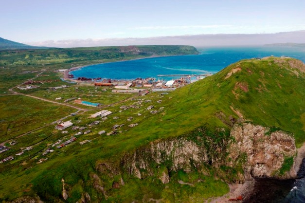
Ebeko is located on the Northern part of Paramushir Island, the second large island off the southern tip of the Kamchatka Peninsula. The closest habitation is the village of Severo – Kurilsk, with 267 people some 7 km south of the volcano. There are 3,100 people within 100 km of the volcano, most of them in Ozernovsky some 90 km to the NNE on the Kamchatka Peninsula proper.

Dec 8, 2016 Ebeko eruption http://www.kscnet.ru/ivs/volcanoes/inform_messages/2016/Ebeko/index.html
The volcano itself is some 1,156 m above sea level and is one of at least 23 volcanoes that make up Paramushir Island. Severo – Kurilsk is the largest populated center on the island. Climate is sub-arctic and is further cooled by a nearby current. Tree coverage is Siberian dwarf pine and alder. The climate is generally wet, snowy when cold and windy.
Imperial Japan ran a military operation out of Paramushir Island during WWII. They were removed by the Soviet Union toward the end of the war. The Soviet Union and in turn the Russian Federation has controlled the island since.
Severo – Kurilsk was destroyed by a tsunami in 1952. It was rebuilt in a higher location. The earthquake was in the 8.2 magnitude generating waves 15 -18 meters high. Over 2,336 died in the tsunami waves at Severo – Kurilsk.
Youtube of the incoming tsunami can be found here:
https://www.youtube.com/watch?v=zbMRjN1EU_E
There was a thriving herring fishery that crashed over the last couple of decades, cutting the population of the island in half since 1989.

Current Serevo-Kurilsk (Photo:

Current location of Severo-Kurilsk (Photo: wikimapia.org)
I have not been able to find a webcam for Ebeko.
KVERT is currently carrying Ebeko as Aviation Color Code yellow with moderate gas-steam activity as of the Feb. 12 daily report.
KVERT page for Ebeko: http://www.kscnet.ru/ivs/kvert/volc.php?name=Ebeko&lang=en

Ebeko crater 2002 http://www.kscnet.ru/ivs/lavdi/staff/belousov/ebeko4.jpg
Volcano
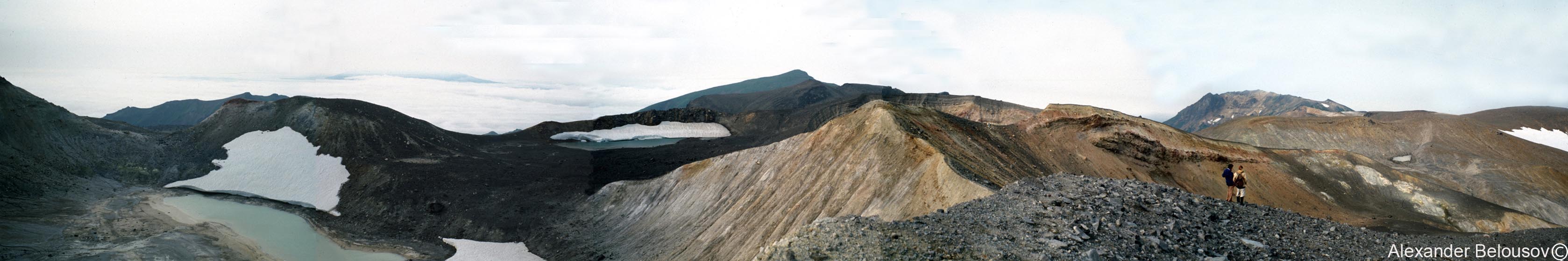
KVERT lists Ebeko as a very new stratovolcano at only 2,400 years old. It is a Somma volcano, refilling a horseshoe some 3-5 km in diameter. The direction of the somma-creating eruption appears to be NNE. The new edifice has mostly refilled the ancestral volcano’s structure. It erupts andesite-basalts and andesites. The flanks are covered with craters and centers of hydrothermal activity.
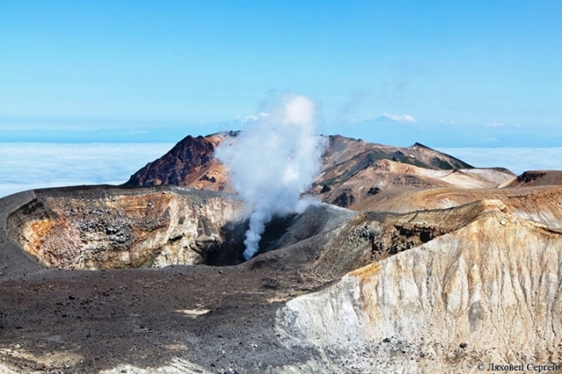
Active Ebeko crater Dec. 2016 (Photo: Sergej Lyachovets)
The volcano itself has a flat summit with three smaller craters, two of which are water filled. One of those tends to be cold and the other much warmer with heat out of the hydrothermal system of the volcano.
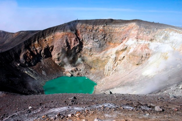
Ebeko summit lake (Rdfr, via Wikipedia)
Being an andesitic volcano in a cold climate, threats from the volcano include but are not limited to blocky lava flows, ash, pyroclastic flows and lahars. The extensive hydrothermal system around the volcano indicates a close and vigorous magma chamber. Fumaroles on Ebeko are described as solfataras, which are defined as fumaroles that emit sulfurous gasses. While the prevailing winds are usually strong, Severo-Kurilsk is close enough that fumes from the fumarole system and eruptions are the occasional problem.
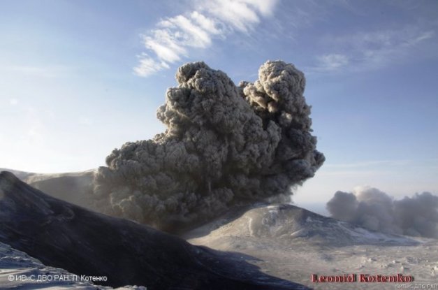
Eruption from Ebeko Dec 15, 2016 (Photo L. Kotenko. IVS FEB RAS)
The volcano sits at the northern end of a complex of five volcanic cones. Neighboring volcano Neozhidanny is considered extinct. There are thick andesitic lava flows in the southern part of the ridge Ebeko occupies. They cover sedimentary rocks of the Okhotsk and oceanic basement. Along with the lavas, there are pyroclastic deposits which may have a basaltic origin. There are significant interglacial andesites between 110 – 20 ka. Neighboring volcanoes of Bilibina, Krasheninnikova and Ebeko are all of young, postglacial andesitic and andesitic-basaltic origin.

Schematic of volcanic activity on northern Paramushir Island. 1 – Present alluvial, marine and lacustrine strata (a), and tallus(b); 2 – andesitic and andesitic – basalt lavas; 3 and 5– glacial deposits; 4 – andesitic lavas; 6 – basaltic lavas, tuffs, tuff-breccias; 7 – undivided volcanic sediment deposits and subvolcanic bodies; 8 – centers of volcanic eruptions; 9 – small volcanoes, lava and cinder cones located on Vernadsky ridge; 10 – relief scarps and erosional limits of calderas; 11 – thermal springs and fumaroles; 12 – drill holes. (From Rychagov et al.)
Alaid volcano is some 30 km WNW from Paramushir Island. Like Ebeko, it is a very active stratovolcano that has yet to demonstrate a significant cone collapse.
The hydrothermal system shows some interesting changes over time. When there is more activity, there appears to be decreasing ratios of sulfur to carbon, sulfur to chlorine, and fluorine to chlorine. At the same time, the ratio of H2S and SO2 increases. This leads to the suggestion that there is a sea-water aquifer above the heat source that may or may not be a shallow magma chamber. This allows magma intrusions to ascend through the aquifer with minimal seismic signals.

Hot summit lake on Ebeko. http://survincity.com/2011/10/volcano-in-the-kuril-islands-ebeko-threw-steam-gas/
Fumaroles near the summit emit low-temperature, HCl and sulfur-rich gas. Numerous hyper-acidic pools are also found. 450 m lower, many hot springs discharge ultra-acidic water into the local stream and in turn into the Sea of Okhotsk. The chlorine flux out of the Yurieva springs is among the highest ever measured in a volcano hydrothermal system.
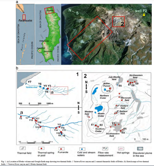
Ebeko hot spring and fumarole locations. Area 1 is the highly acidic Yureiva River. Area 2 is the summit and the fumarole and hot spring fields just east of the summit. https://www.researchgate.net/publication/284227482_Volcano-hydrothermal_system_of_Ebeko_volcano_Paramushir_Kuril_Islands_Geochemistry_and_solute_fluxes_of_magmatic_chlorine_and_sulfur
There are a number of papers studying the magmatic hydrothermal system underlying Ebeko and the northern part of Severo – Paramushirskaya (North Paramushir) Island. Like we have seen in other Kamchatka volcanoes, the hydrothermal systems move rare metal and polymetallic ores from host rocks and deposit them in the surface manifestations of that activity – hot springs, fumaroles, solfataras and mud pots with the east side of the island being the most active. Heat source for this system is some 2 – 3km below the surface though there is no large magmatic center directly under Ebeko.

Sulphur encrusted fumarole inside Ebeko crater (Photo: Alexander Belousov)
There is a high-sulfide fluid system above the heat and ore source. This system also is in the crater. There is a low sulfide system sitting between the high-sulfide system and the exterior oceanic water source. The interaction between these two systems is complex and drives deposition of minerals around the volcano.
A new set of fumaroles opened up in 2007 when Ebeko woke for its most recent series of eruptions.
Heat flux from the hydrothermal system lends itself to geothermal energy exploration. Some authors believe they can extract up to 100 MW of thermal energy from the hydrothermal system. There was interest in geothermal before the fall of the Soviet Union, but that interest disappeared when the Soviet Union did. It has not been pursued in recent years.
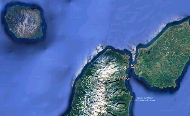
Google maps screen capture showing Alaid Volcano at the upper right and Ebeko and Servero – Kurilsk
Eruptions
Ebeko is one of the most active volcanoes in the Kuril Islands. It has 19 eruptive periods over the last 400 years with 13 of them in the 20th Century alone. Most of the eruptions are in the VEI 1 – 2 range. Oregon State describes the 1859 eruption as a VEI 3.
Most of the explosions eruptions have a phreatic component due to the significant hydrothermal systems below the volcano. Both ash and steam are prevalent.
The creation of the somma structure is as yet undated.

Tectonics of Pacific Plate subduction under Okhotsk Plate, Kuril Islands and Kamchatka triple corner. http://javiciencias.blogspot.com/2011_03_01_archive.html
Tectonics
Ebeko is a subduction volcano, driven by the subduction of the Pacific Plate under the Okhotsk Sea Plate. The Kuril Trench (sometimes referred to as the Kuril – Kamchatka Trench) is located offshore to the east. General motion of the Pacific Plate along this subduction region is east to west. As with all subduction arcs, there is always the possibility of significant earthquakes over time.
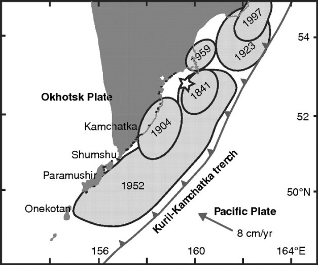
Slip distribution of Nov 1952 Kamchatka earthquake http://www.bssaonline.org/content/100/4/1695/F1.expansion.html
The November 4, 1952 earthquake was officially measured at magnitude 8.2. Waves from this ran across the Pacific basin, with heights at or above a meter in New Zealand, Alaska and California. Waves of 6 m hit Hawaii, damaging the Big Island and Midway Island. Some years later, strength of the earthquake was revised upwards to a magnitude 9.0.
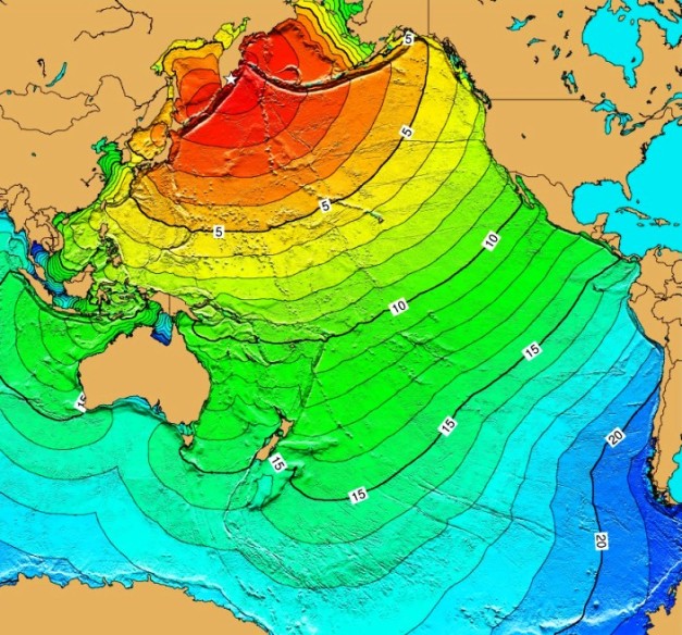
1952 Kamchatka tsunami. Numbers are travel time of the wave in hours across the Pacific. http://www.wsspc.org/resources-reports/tsunami-center/significant-tsunami-events/1952-kamchatka-tsunami/
Wave heights varied significantly around Kamchatka and the Kuril islands ranging from 4 – 18 m on Paramushir Island. http://www.bom.gov.au/tsunami/history/1952.shtml
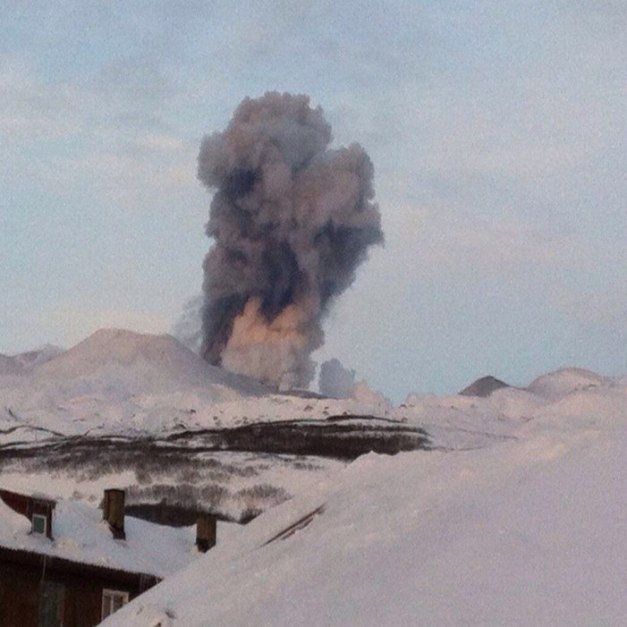
Ebeko volcano eruption Dec. 14, 2016. Note mixed ash and steam clouds. http://earth-chronicles.com/natural-catastrophe/the-ebeko-volcano-threw-a-column-of-ash.html
Conclusions
Ebeko has an active heat source, a magma source, and a significant amount of water in and around those sources. Generally this powers a widespread and vigorous set of surface fumaroles, hot springs, mud pots and other hydrothermal systems. The system suffered a flank collapse in not so distant geologic history and rapidly rebuilt the edifice. Given its ongoing activity, there is no reason to believe this activity will halt any time soon. While observed eruptions were not overly large, the combination of magma and water is generally a dangerous one. I do not believe this system will calm down any time soon.

Ebeko volcano from the east http://www.kscnet.ru/ivs/lavdi/staff/belousov/ebeko2.jpg
Additional information
https://href.li/?http://www.kscnet.ru/ivs/volcanoes/inform_messages/2016/Ebeko/index.html
https://volcano.si.edu/volcano.cfm?vn=290380
https://www.volcanodiscovery.com/ebeko.html
https://www.geothermal-energy.org/pdf/IGAstandard/WGC/2010/1204.pdf
http://nopr.niscair.res.in/bitstream/123456789/1881/1/IJMS%2037(2)%20166-180.pdf
http://geo.web.ru/conf/khitariada/1-2003/informbul-1_2003/magm-20e.pdf
http://meetingorganizer.copernicus.org/EGU2015/EGU2015-7328.pdf
http://file.scirp.org/pdf/OJG_2013102215520581.pdf
https://pangea.stanford.edu/ERE/db/WGC/papers/WGC/2015/12015.pdf


Ebeko’s colour code was raised to Orange this morning with new emissions.
LikeLike
It was about time that Etna produced a decent paroxysm again! But it seems that it has reached its peak already.
LikeLike
And here are some new images of the Ebeko eruption from 27 Febr. Look how the snow nearly reaches the roofs! – I really think this the most remote place in the world, more so than the Fidji Islands…
LikeLike
Looks like they are clearing the roofs of deep snow, which tends to build it up around the walls below. Cheers –
LikeLike
I am somewhat amazed that 10 out of 13 U.S. volcanoes listed here (MIROVA) have had thermal anomalies in the last month. For example, in Augustine two low-level incidents near the crater were registered last week. That shows us that the active volcanoes are very much “alive”, even if no activity is reported because it might be minor and nothing to write home about.
LikeLike
Bogoslof has been quiet for the last three weeks but is “roaring back to life” 😉 just now. Last Activity Notice reads: “A significant explosive eruption that began at Bogoslof volcano at 7:36 UTC on March 8 (10:36 pm AKST on March 7) is continuing, as indicated in seismic, lightning, and infrasound data. The ash cloud from the eruption has been observed to 35,000 feet in satellite images and is heading east. The current Aviation Color Code is RED and Alert level is WARNING.”
LikeLike
That last eruption was a 3-hour affair. Dusted Unalaska. Write-up from local fish wrapper is at the link below. Cheers –
https://www.adn.com/alaska-news/2017/03/08/bogoslof-volcano-sends-ash-over-unalaska-in-3-hour-eruption/
LikeLike
New post is up! 🙂
LikeLike
Wow this volcanic system is impressive. I imagine the Russian people living there will have to evacuate.
Both the volcanoes and the mysterious Kurils are so fricking beautiful.
Thanks for sharing.
LikeLiked by 1 person
Pingback: June 22 Eruption at Raikoke, Kuril Islands |
Pingback: Ushishur, Kuril Islands, Russia |