
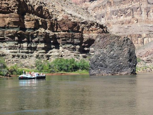
Lava Flow next to the Colorado River, Grand Canyon. https://answersingenesis.org/blogs/georgia-purdom/2014/06/07/the-grand-canyon-and-my-comfort-zone/
Granyia asked a couple questions a while ago that got me looking at recent volcanic activity in Arizona. Turns out that there are many fields in the state, the most recently active are the Uinkaret north of the Grand Canyon in far NW Arizona and the San Francisco volcanic field centered on Flagstaff in north central Arizona.
As we have seen in New Mexico, activity is mostly basaltic with lots of lava flows, little pyroclastic activity, numerous cinder cones, domes, the occasional stratovolcano and most importantly activity within the last 1,000 years for both fields.
Arizona is generally a dry, arid state, with desert at lower elevations and vegetation at higher elevations. It is home to nearly 7 million people. The state has a significant military presence. It also hosts a number of Indian reservations on about a quarter of the total land in the state.

Young volcanic fields of Arizona. https://wryheat.wordpress.com/2011/01/27/young-volcanic-fields-of-arizona/
Arizona also has significant historic volcanic activity, with a lot of it relatively recent. The Uinkaret and San Francisco volcanic fields will be discussed in detail later.
Additional volcanic fields depicted above in red include the Springerville Volcanic Field is located just across the border from the Jemez Linement and represents the western end of that line of volcanic fields. It has been active for 8 Ma. Most of its basaltic flows are between 2.1 Ma and 300,000 years old.
The San Bernardino volcanic field is at the far SE corner of the state. It consists of cinder cones, maars and lava flows. It was active between 1 Ma and 27,000 years ago. A northern extension of the valley contains hot springs
The Sentinel volcanic field is west of Gila Bend in the SW portion of the state. Its basalt flows date 2 – 6 Ma.
The Pinacate volcanic field is across the border in Sonora. It consists of hundreds of cinder cones, 11 large maars. It has been active for 2 – 3 Ma.
Older activity dating 5 – 16 Ma generally lies on the transition zone between the Colorado Plateu and the Range and Basis province in southern Arizona. Activity dating between 11 – 38 Ma is generally confined to the Range and Basin Province, though there is a significant patch just south of the Springerville volcanic field.

Satellite image of north rim of Grand Canyon showing Uinkaret and Shivwitts volcanic fields. https://watershed.ucdavis.edu/education/classes/ecogeomorphology-grand-canyon-2016/flogs/fire-and-water-cenozoic-volcanism-and-lava-dams-grand
Uinkaret Volcanic Field
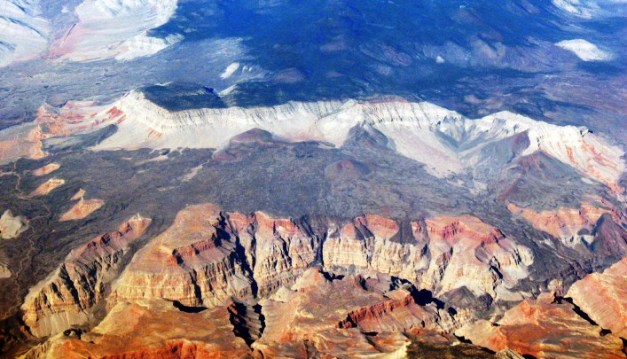
The Uinkaret volcanic field occupies part of the northern rim of the Grand Canyon. It covers some 1,500 km2 in total area, stretches some 80 km north of the Colorado River, and was active as recently as a 1,000 years ago. Few people live within 30 km of the field, though nearly 150,000 live within 100 km. It is some 180 km east of Las Vegas.
The field is centered between a pair of active fault lines that cross the canyon perpendicularly. It contains at least 213 cones and associated lava flows. Eruptions began some 3.6 Ma. Most of the early activity was effusive with few tephras found. The USGS writeup on the field does qualify that with a suggestion that tephras could have been eroded away.
After the initial eruptive period, the field was relatively quiet for another 2.6 Ma, waking up some 600,000 years ago. There was prolific activity for 100,000 years which continued less intense until 1,000 years ago.

Vulcan’s Throne, Grand Canyon http://www.gettyimages.com/detail/news-photo/the-black-cinder-cone-of-vulcans-throne-was-formed-10-000-news-photo/80895079#the-black-cinder-cone-of-vulcans-throne-was-formed-10000-years-ago-picture-id80895079
Being as close to the Grand Canyon as it is, lava flows periodically flowed down into the canyon damming the Colorado River several times starting some 1.2 Ma ago. Some of these dams were quite large, with the highest measuring over 600 m tall. Total length of the longest was over 135 km. The lava dams created large lakes behind them. As the water eroded the lava, generally via waterfall action over the top of the dams, the dams failed, creating massive floods downstream. The typical dam may last on the order of 20,000 years. Two of the lakes were large enough to stretch well into Utah beyond the current shoreline of Lake Powell.
Vulcan’s Forge, Grand Canyon. Magma sill left in the river.
A 2004 paper by Fenton, et al investigated the lava dams and catastrophic floods in the Colorado River. The authors concluded that the river had been dammed at least 13 times by lava flows. Five of those were large enough to release cataclysmic floods when they failed. Some deposits from the floods are 200 m above river level. The elevation of the river fluctuated with the creation and destruction of the dams but is thought to remain within 40 m of its current level over the last 600,000 years.

Lava dam remnants in the Grand Canyon https://www.researchgate.net/figure/222400040_fig3_Figure-3-Upstream-view-of-the-remnants-of-the-Hyaloclastite-Dam-across-from-Whitmore
A second paper describes three volcanic fields on the western Grand Canyon. From west to east they are Grand Wash, Shivwits Plateau and Uinkaret Plateau with Uinkaret being the youngest. Total volume of lava from the field in the inner gorge is estimated at over 22 km3. A typical lava flow from Uinkaret is some 15 m thick. These flows were channeled in the gorge and thickened to over 45 m. The majority of the initial flows that went into the canyon eventually encountered water creating pillow lava structures. Some also reacted explosively with the water creating hydroexplosive tephras that would form bedding upstream of the dam. After formation of the dam, downstream lavas were operating in what was essentially a dry environment.

Overhead photo of Uinkaret interaction with Grand Canyon showing location of lava dams. http://geosphere.gsapubs.org/content/11/5/1305/F13.expansion.html
Uinkaret is constrained by a pair of faults – Toroweap and Hurricane. Lava would tend to channelize along the fault lines at times.
The closest cinder cone to the Canyon is Vulcan’s Throne, a late Quaternary eruption on the Toroweap Fault. It sits on the edge of a 1,000 m deep inner gorge. There is a Vulcan’s Forge which is either the remnant of dike – sill system well into the canyon or the remains of a lava flow.

Lava dam outburst flood deposit filling side channel of Colorado River. http://azgeology.azgs.az.gov/azgs/image-of-the-day/images/outburst-flood-deposit-filling-former-channel-colorado-river
The youngest lava flow is the Little Springs basalt dated some 1,000 years ago. It came from a pair of associated vents. A cinder cone active during the eruption was partly rafted away by the lava. Lava from this eruption covered pottery fragments indicating indigenous peoples lived in the volcano field when it was active.
Interestingly enough, Little Springs is only a few km south of Mount Trumbull, which hosts the oldest basalt in the field.

Satellite photo of San Francisco volcanic field. Roads are depicted along with Flagstaff. Some features are named. https://en.wikipedia.org/wiki/San_Francisco_volcanic_field
San Francisco Volcanic Field
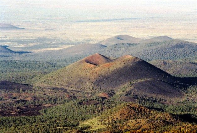
The San Francisco (alternately San Franciscan) Volcanic Field lies mostly north of Flagstaff, AZ. The field is centered on the San Francisco Mountain, the remains of a large extinct stratovolcano with an amphitheater on one side. The next highest point is Kendrick Peak, a neighboring volcanic dome nearly 3,200 m above sea level. The entire field covers 4,700 km2 and has more than 600 cones, domes and lava flows. Activity has shifted east over time. The field has been active for around 6 Ma.
There are over 23,000 people within 5 km of the field with 190,000 within 100 km.

Lava flow from Strawberry Crater, San Francisco volcanic field. https://www.pinterest.com/kataheyginther/tectonic-plates/
The field also includes the youngest volcano in Arizona (contemporaneous with Little Springs in the Uinkaret), Sunset Crater, another scoria cone with associated lava flows.

NASA TERRA satellite oblique view of San Francisco Mountain showing the flank collapse and subsequent amphitheater. Sunset Crater is the cinder cone with the light colored tip in front of the amphitheater. https://www.nasa.gov/multimedia/imagegallery/image_feature_879.html
San Francisco Mountain is the only stratovolcano in the field. Its highest point is named Humphreys Peak and is 3,851 m high. It was active between 1 Ma and 400,000 years ago. The amphitheater appears to be caused by explosive flank collapse and lateral blast. Total volume of San Francisco Mountain is some 80 km3.
The field is also populated by a number of domes. They include dacite and rhyolite lavas, meaning the lavas evolved a bit over time.

SP Crater in the San Francisco volcanic Field https://earthobservatory.nasa.gov/IOTD//view.php?id=49450
Sunset Crater is the youngest eruption. It created a 340 m high scoria cone and a pair of lava flows some 1,000 years ago. These flows extend 2.5 km and 9.6 km from the crater. There is a 10-km long fissure extending to the SE that produced small spatter cones and a 6.4 km lava flow to the east. Ash covered over 2,100 km2 and forced local Indians to abandon settlements.
Sunset Crater, Arizona
For most of the lifetime of the field, it was seeing basaltic eruptions every 3,000 – 17,000 years. For the past 250,000 years, magma production appears to have decreased a bit and along with it eruption frequency. The slow eastward drift of activity is described in a paper by Tanaka et al as caused by the absolute westward movement of the North American Plate, leading to some speculation that the field is the product of a minor hot spot.

Grand Falls, San Francisco volcanic field. Photo courtesy Erik Klemetti’s Eruptions blog https://www.wired.com/2017/03/exploring-mysterious-volcanoes-arizona-yes-arizona/
Like we saw with the Uinkaret, lava flows spilled into a neighboring river gorge, this one was the Little Colorado River, and created a lava dam. Flows from Merriam Crater and a pair of associated cinder cones produced the Grand Falls lava flow which spilled into the Little Colorado River gorge, creating a dam, modifying the flow path of the river, and eventually Grand Falls itself.

Lava River Cave, San Francisco volcanic field http://www.sfgate.com/travel/article/Park-centennial-spurs-lava-tube-tours-in-Hawaii-7044926.php#photo-9674963
The field also contains the Lava River Cave, a 1.6 km long lava tube formed some 700,000 years ago. http://www.gardenbetty.com/2014/11/volcanoes-lava-flows-and-lava-tubes-in-arizona/

Rafting of part of the cone of Red Mountain. https://skyaboveus.com/climbing-hiking/Hiking-to-the-Hoodoos-in-Red-Mountain-Amphitheater
Red Mountain is a breached 300 m high cinder cone. It is around 740,000 years old. Appears a chunk of the cone was rafted out and away from the rest of the cone by a late stage lava flow. There is some discussion about phreatomagmatic blasts doing the deed, but we normally don’t see a lot of that in cinder cones. On the other hand, we do see rafting from time to time.

Schematic of tectonic zones of Arizona and New Mexico. Volcanic fields are highlighted. Note the ring of volcanic fields around the southern edge of the Colorado Plateau. Screen capture from Tanaka et al.
Tectonics
Volcanic activity across Arizona has been prolific over the last 10 Ma. The state can be divided into three geologic provinces: The Colorado Plateau to the north; a transition zone in the middle; and the Basin and Range Province in the southern 40% of the state. The vast majority of the volcanic activity took place around the periphery of the Colorado Plateau and the transition zone.
At the top level, Arizona is part of the North American Plate. This portion of the plate has two major tectonic provinces – the slowly spreading Basin and Range Province to the south and the Colorado Plateau (block to the north). It is the interaction between the two provinces that drive volcanic and earthquake activity in the state.

Tectonics of the Western US http://www.colorado.edu/geolsci/Resources/WUSTectonics/tectonics.html
Formation of the Basin and Range Province started some 20 Ma. It runs through much of the desert west, primarily Nevada, southern parts of Arizona and New Mexico, and much of north and western Mexico. It is an area of extension of the lithosphere, as that part of North America relaxes following the subduction of the Farallon Plate. The Pacific Coast is no longer primarily a subduction zone, as the Pacific Plate motion along it is mostly strike – slip up the San Andreas Fault. Subduction starts again in Northern California and north offshore Oregon and Washington State.
The extension rifted the mountains in the region into more than 400 mountain and basin combinations. The extension also thinned and uplifted the continental crust allowing hot, young magma to make its way from below the plate to the surface.
The other major player in Arizona is the Colorado Plateau. It is an ancient chunk of North America that has remained largely intact over the last 70 Ma, though it has uplifted. The plateau is variously referred to as a block or microplate. It is on the order of 500,000 km2 in size. While there has been sporadic volcanic activity through the block, the most vigorous activity has been along its edges on the west, south and east. This ranges from Utah through Arizona, New Mexico and Colorado. Interestingly, not a lot of activity has been observed around the northern portion of the block.

Schematic of possible rotation of the Colorado Plateau http://arizonageology.blogspot.com/2015/10/new-report-on-cordilleran-tectonics.html
There are two competing theories for the formation of the Rio Grande Rift in NM. One would be a failed crustal rift. A second and to me perhaps more interesting is the rift is caused by a degree or two clockwise rotation of the Colorado Plateau. Such a rotation would tend to open pathways for large amounts of young, hot mantle sourced magma to reach the surface. And we see just that.

Colorado Plateau http://gotbooks.miracosta.edu/geology/regions/colorado_plateau.html
A similar argument would also take place to describe the prolific and relatively young volcanic activity along the Jemez Lineament in NM and the line of volcanic fields from southern Utah to the Grand Canyon, to the San Francisco Volcanic Field near Flagstaff and on to the Springerville Volcanic Field on the eastern border of Arizona marking the western end of the Jemez Lineament.
One of the explanations for the line is a traveling hot spot, though the route of travel does not precisely parallel that of the Yellowstone hot spot. Another would be that these various fields mark locations where the rotation of the plateau opened the crust to passage of hot, young magma from the mantle below.
Final piece of the puzzle would be to ask what would rotate a half a million square kilometer ancient chunk of North America. While I have found no definitive answers, I believe the forces that created the Rocky Mountains (Laramide Orogeny), and are producing the ongoing uplift of the block are somehow involved.
I tend to like the rotation explanation if for no other reason than it simplifies the tectonic discussion. Otherwise we end up with multiple hot spots wandering randomly around Arizona and NM. If they are doing that in Arizona and NM, why not elsewhere in the continental North America?

Toroweap Point lava flow into the canyon http://www.enlightphoto.com/views/2015/05/06/volcanoes-in-the-grand-canyon.htm
Conclusions
I find it healthy practice pay close attention to any region with volcanic activity during the last thousand years. And these two fields fit that bill precisely. Both fields were prolific producers of basaltic lavas and scoria (cinder) cones. The underlying tectonics producing the intraplate magmas and allowing them to reach the surface has not changed in appreciably in recent history though magma volumes and eruption frequency seems to be tailing off a bit in the San Francisco volcanic field. There are predictions of the next round of eruptions. They are entirely based on what came before and the timing between successive eruptions over the history of the fields. Though no magma bodies are yet imaged, it would not surprise me to see future activity out of either or both fields.
Lava Flow into the Grand Canyon https://www.flickr.com/photos/drjerque/4273613130
Additional information
https://volcanoes.usgs.gov/volcanoes/uinkaret_field/
https://volcano.si.edu/volcano.cfm?vn=329010
http://volcano.oregonstate.edu/uinkaret-volcanic-field
http://www.sas.rochester.edu/ees/RareGasLab/Fenton_etal_JGeology.pdf
https://watershed.ucdavis.edu/education/classes/files/content/page/Ch7_BigHistory.pdf
https://pubs.usgs.gov/fs/2001/fs017-01/
https://volcano.si.edu/volcano.cfm?vn=329020
http://www.aasg2015.azgs.az.gov/sites/default/files/San-Francisco-Volcanic-Field_web.pdf
http://www.swxrflab.net/sfvolfld.htm
https://www.nasa.gov/multimedia/imagegallery/image_feature_879.html
http://www.azgs.az.gov/arizona_geology/archived_issues/Winter_2000.pdf

