
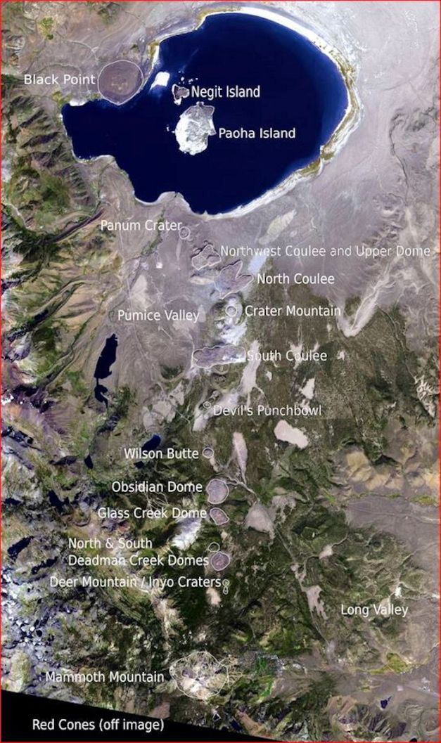
Annotated satellite image of Mono-Inyo Craters. Mammoth Mountain dome domplex is at the bottom of the image. Mono Lake is at the top. Long Valley is to the east (right) of Mammoth Mountain. Image courtesy Wikipedia Mono-Inyo Craters
The pair of large earthquakes in southern California reminded me of the tectonics involved with the Walker Lane. The first quake on July 4 M6.4 was thought to be the main event right up until the M7.1 arrived just over 34 hours later. There have been multiple aftershocks in the M5+ range. You don’t often get to see a foreshock this large.
Not to be outdone, the California Volcano Observatory issued an alert following an earthquake swarm south of the Coso Volcanic Field, though they did not observe any inflation or predict any imminent volcanic activity.
We previously covered Walker Lane tectonics and associated volcanic fields October 2018. The region contains one of the three most recent caldera locations in the continental US, Long Valley. The most recent volcanic activity in Long Valley created a 40-km string of craters, domes and lava flows north and west of the caldera proper called the Mono – Inyo Craters. Long Valley also has an active hydrothermal system.
We will look at the Mono – Inyo Craters and the greater Long Valley region.

Inyo Craters on the eastern flank of Deer Mountain. Image courtesy USGS
Mono–Inyo Region
First point about Mono–Inyo is that there is a boatload (or dump truck full) of information about Long Valley and Mono–Inyo, so my problem putting this together is not finding the information but keeping myself from getting buried in it. I have linked to several top-level papers on the region for those readers who want more information. For the casual reader, the Wiki on Mono-Inyo is surprisingly complete. There are worse places to start.
Much of the early work on Long Valley and Valles Caldera was done by Roy A. Bailey, a USGS geologist who first mapped the Bishop Tuff (named by him and his work) and its source at Long Valley. He is responsible for much of the published work on Long Valley. Bailey carefully documented products and processes leading to the formation and evolution of large caldera-forming volcanic systems. He retired in 1995 after 42 years and passed away in 2003.

Eroded columns from Bailey Tuff. These are located around Crowley Lake. Image courtesy Budget Travel with Kids blog
The region has been used by the Mono Paiutes for centuries. They collected obsidian to make sharp tools and arrow points. They should have been in the area during its most recent eruptions. Gold rush boomtowns grew around Mono Lake in the second half of the 19th Century. Trees on the flanks of the domes were logged to provide timber for the towns in the 1870s.
The Los Angeles Department of Water and Power purchased large tracts of land in the 1930s to control water rights and provide water to Los Angeles. They dug an 18.5 km tunnel under the southern end of Mono Craters from 1934 – 1941. This was a dangerous job as the miners dealt with loose gravel, flooding, and pockets of CO2 gas. They lost 12 men in the project.

Mammoth Mountain ski resort during the winter. Image courtesy On the Snow
Pumice has been mined in the area since 1941. Some geologic training for the Apollo astronauts took place in the region in 1971. Exploratory geothermal drilling done in 1971 did not show potential and was abandoned. Mono Lake was the shooting location for the 1973 Clint Eastwood movie High Plains Drifter.
Today, Mammoth Lakes is a resort town that sits at the base of Mammoth Mountain. It has a permanent population around 8,000 that regularly swells larger than 40,000 on ski weekends. It is a year-round destination resort that has access to biking, fishing, and golf during the summer months in the Sierra.
The region is part of the Central Basin and Range of the North American Desert. Annual precipitation ranges 36 – 58 cm/year. Temperature lows in winter average around -5 C; highs in the summer range around 26 C. Most of the surface is barren, with slopes covered by pine forests and partial greenery. Soils are deep pumice in the process of being broken down by weathering.

Long Valley caldera. Image taken on NE rim looking to the west. Resurgent dome is on the floor of the caldera. Image courtesy Wikipedia
Long Valley
The Long Valley volcanic field was created at the transition zone between the Sierra Nevada block and Basin and Range tectonic zones. This region is also the eastern arm of the Walker Lane as it works its way north along the California – Nevada border, making it a surprisingly complex tectonic region in North America.
Eruptive history overlaps several smaller mafic to silicic volcanic fields in this transition zone, Big Pine, 50 km south and Coso, 100 km south. By 4.5 Ma, decompressing mantle began leaking batches of magma below the current location of Long Valley to 40 km SW into the Sierra Nevada and 30 km NE into the Adobe Hills.
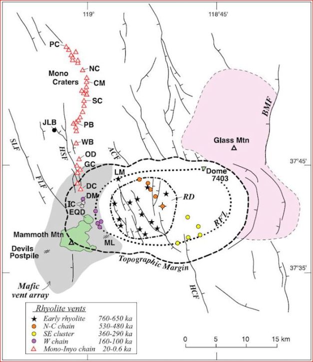
Schematic of greater Long Valley region with Mono-Inyo Craters clearly identified (red triangles). Extent of Glass Mountain eruptive products is pink to the east. Greater Long Valley depression is depicted as the Topographic Margin. RFZ – Ring Fault Zone of the caldera proper. RD – Resurgent Dome. Mammoth Mountain dome complex is depicted in Green to the west of the caldera. Image screen capture from Hildreth, 2004.
Precaldera dacites started erupting 3.5 Ma and stopped 2.5 Ma. Rhyolite eruptions began 2.2 Ma and continued for the next 2 Ma. This included the caldera forming eruption 760,000 years ago that created the Bishop Tuff. Mafic eruptions resumed some 200,000 years ago and continue to recent years.
Glass Mountain is a large precaldera complex at the NE periphery of the caldera. It is high silica rhyolites that erupted 2.2 Ma to 790,000 years ago out of at least 60 eruptive centers. There are at least 50 km3 of rhyolitic lava flows, domes, tuffs, fans of pyroclastic materials, and reworked eruptive debris. Exposed rhyolite pile thickness at the caldera wall is greater than 1,050 m.

Precaldera magma chamber schematic for Long Valley. Precaldera dacites and Glass Mountain locations are depicted. Screen Capture from USGS Professional Paper 1692, Roy Bailey, 2004
At least 17 Plinian events distributed Glass Mountain rhyolites from the Pacific Ocean to Utah. Total magma volume released by Glass mountain may be greater than 100 km3 of high silica rhyolites released in two groups. The older sequence 2.2 – 1.3 Ma has at least 35 eruptive units, all on the more evolved end of the zoned Bishop Tuff spectrum.
The caldera forming Bishop Tuff eruption took place 760,000 years ago, releasing 600 km3 of gas-rich, compositionally and thermally zoned rhyolite over a 6-day long eruption. This permitted a 2 – 3 km subsidence of the magma chamber roof, creating the caldera. About half the erupted magma was distributed radially outside the caldera. The other half ponded in the caldera itself. The Long Valley depression measures 17 – 35 km and contains the 12 x 22 km caldera. Bishop Tuff in the caldera measures up to 1,500 m thick in the eastern third of the caldera.

Postcaldera rhyolite distribution. Early Rhyolite lavas are in red and tuffs are in yellow. Three clusters of moat rhyolites are depicted. North Moat in orange. SE in green. West in blue. MK – Mammoth Knolls. Image screen capture from Hildreth, 2004
Post collapse eruptive activity took place 750,000 – 100,000 years ago inside or near the caldera’s ring fault zone. This activity is consistent with a reorganized, mixed magma reservoir. The units are a rhyodacite resurgent dome, voluminous Early Rhyolites and three sets of Moat Rhyolites. The Moat is defined as the flat space between the resurgent dome and the ring fault defining the caldera edge.
The Early Rhyolite erupted within 100,000 years of the caldera collapse. It is around 100 km3 of uniform rhyolites. The volume of these eruptions is greater than the precaldera Glass Mountain activity. There were multiple eruptions from at least 13 exposed vents that produced at least 14 exposed lava flows and domes, various tuffs, pyroclastic flow deposits, tephras between 751,000 – 652,000 years ago. The activity took place within the caldera and did not leave ash layers outside the caldera, indicating the eruptions were water rich and otherwise depleted in volatiles. Erupted composition is similar to the Bishop Tuff material erupted late in the caldera forming sequence. These materials are as thick as 650 m near the center of activity in the western portion of the caldera floor.

Postcaldera magma chamber depicted including Early Rhyolites, Mammoth Mountain, and rising magma that fuels activity there and the Mono-Inyo Craters. Screen Capture from USGS Professional Paper 1692, Roy Bailey, 2004
Resurgent dome uplift took place at the same time as the Early Rhyolite eruptions and was largely complete 500,000 years ago. The dome is roughly 10 km in diameter and 400 m high with an estimated total volume of 10 km3.
The Moat Rhyolites include the North-central rhyolite chain, Southeastern rhyolite chain and West moat rhyolites. The North-central rhyolites are five small volume units totaling around 1 km3 that erupted 527,000 – 481,000 years ago. After a 120,000-year hiatus, the Southeastern rhyolite cluster of five vents erupted in the SE moat. These eruptions took place 333,000 – 288,000 years ago and produced 1.5 km3 of low temperature rhyolites. The West moat rhyolites erupted 150,000 years later west of the resurgent dome. These eruptions created four small lava domes and the large West Moat Coulee, erupting 5 – 8.5 km3 of material 161,000 – 97,000 years ago.

Long Valley caldera image taken from the top of Mammoth Mountain. Ski areas in the foreground right. Image courtesy USGS via the Watchers blog
Most of the 15 moat rhyolites and all those younger than 300,000 years ago are crystal rich, low temperature magmas. This suggests that active separation of melt from crystal has stopped.
Mammoth Mountain is a silicic dome cluster outside the west rim of the caldera though within the western rim of the valley. It erupted 3 – 5 km3 of trachydacites and alkalic rhyodacites from at least 25 – 30 overlapping domes and lava flows. These magmas are unrelated to the residual Long Valley magma reservoir and represent a new magma intrusion. Lavas and tephras date 111,000 – 57,000 years ago, with half of it erupting 67,000 – 57,000 years ago.
Mammoth Mountain is older than the Mono-Inyo chain and is not magmatically related to it. Recent unrest beneath Mammoth Mountain is likely a new injection of mafic dikes like those that fed the neighboring Mono-Inyo activity in the last 200,000 years ago.

Schematic of 6 successive magma batches in the Long Valley region. 1 – pre-caldera dacites. 2 – Glass Mountain. 3 – Long Valley Caldera (Bishop Tuff). 4 – Mammoth Mountain. 5 – Mono Craters. 6 – Mono Lake domes. Image screen capture from Hildreth, 2004
In all, six successive magmatic intrusions drove activity in Long Valley over the last 3.5 Ma. These intrusions are discrete, unrelated events / batches of magma. Precaldera dacites were erupted 3.5 – 2.5 Ma in the NW portion of the valley depression. Glass Mountain erupted high silica rhyolites 2.2 – 0.79 Ma. The Long Valley caldera erupted zoned rhyolites as the Bishop Tuff 760,000 years ago and the Early and Moat rhyolites 527,000 – 97,000 years ago. Mammoth Mountain erupted trachydacites and rhyodacites 110,000 – 57,000 years ago. Mono-Inyo Craters was a propagation of dike-fed chain of rhyolite domes 50,000 – 650 years ago. Finally, we have the youngest new focus of activity in Mono Lake 14,000 – 250 years ago,

Mammoth Hot Creek. Multiple hot springs along this creek. Periodically closed to bathers due to occasional lethal temperatures. Image courtesy Sygic Travel
Hildreth in 2004 writes that the mantle-driven magmatic focus under Long Valley has moved repeatedly, allowing the formerly vigorous Long Valley magma chamber to crystalize. The intercaldera eruption rate has declined by at least two orders of magnitude in the last 650,000 years. There is a lack of crystal poor rhyolites in the last 300,000 years. The moat rhyolites have been limited in volume and there is an absence of postcaldera mafic volcanism within the caldera or north and south adjacent to it. There are low thermal gradients inside the caldera.
Long Valley has a robust hydrothermal system, with active hot springs, fumaroles and high heat flow in many parts of the caldera, particularly in the SE moat and adjacent flanks of the resurgent dome.

Mammoth Hot Creek east of Mammoth Lakes. Image courtesy American Southwest.net
Magma continues to rise in three general areas, the south moat of the caldera, the High Sierra south of the caldera and beneath Mammoth Mountain. Most recent activity was in the south moat in 1980 and 1983 and Mammoth Mountain in 1989 thought to be dikes rising within 2 – 3 km of the surface. The most recent south moat eruption was 64,000 years ago creating a 3 km basaltic lava flow. The most recent Mammoth Mountain eruption was the mammoth Knolls rhyolite dome complex 150 – 100,000 years ago. Long period earthquakes 10 – 25 km deep indicate that new basalt is being injected into the system.
There is no partly molten magma chamber underneath Mammoth Mountain. This means that new magma flows through a complex of dikes and sills beneath the system to a depth of 10 km releasing gasses to a shallower gas reservoir and in turn to shallow fissures and faults, leading to widespread dispersal in surface soils.
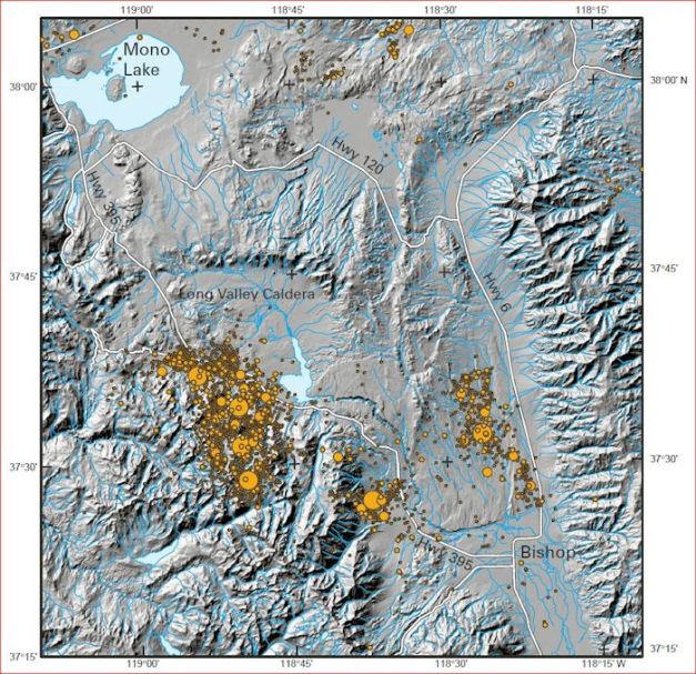
Shaded relief map of Long Valley – Mono Craters region showing epicenters of earthquakes greater than M 3 1978 – 1999. Screen capture from Response Plan for Volcano Hazards in the Long Valley Caldera, USGS Bulletin 2184, 2002
The strong volcanic unrest announced itself in 1978 with a M 5.8 located SE of the caldera. Over the next 18 months seismic activity migrated NW to the southern margin of the caldera. Three M 6 earthquakes struck the southern margin of the caldera May 1980. These were followed by a “rich aftershock sequence” prompting the USGS to release a formal Hazard Watch. The fourth M 6 earthquake struck hours after the Hazard Watch was put in place.
By 1982, there was earthquake activity and a 25 cm uplift of the resurgent dome in the center of the caldera. Geologists published notice of potential volcanic hazards due to the uplift in the LA Times May 1982 generating outrage and denial. It took a decade working with local authorities to get eventual acceptance of the new hazard. There were frequent earthquakes and magmatic CO2 emissions in 1990. These were immediately followed by an 11-month long earthquake swarm beneath Mammoth Mountain. There were four fatalities due to the CO2 emissions, one in 1998 and three in 2006. The caldera quieted down 2000 – 2011. Uplift resumed 2011 – 2014 along with low level earthquake activity in the caldera and beneath Mammoth Mountain. This activity continued through May 2016.

Location of ski patrol accident April 2006 on Mammoth Mountain where three died. Two officers fell into a 6+ m deep hollow, snow cave on the flanks of Mammoth Mountain. Accident was more weather related than any changes in an active fumarole. Exceptionally heavy spring snow completely covered an active vent. The hot gasses melted a snow cave over the vent. Normally, action of hot vents keep up with snowfall so that there is always a hole over the vent that can be easily avoided. This one had snow directly over the cavity. Crew was replacing fencing around the vent. Did not realize they were standing on an opening and went in. Atmosphere at the bottom was estimated greater than 90% CO2. Third ski patrol died trying to save the first two. Image courtesy Mitch Weber via Smithsonian GVP
Total volume of magma thought to drive the resurgent dome uplift since 1979 is thought to be around 0.3 km3 of basalt. This is nearly 3 times the volume erupted in the most recent rhyolitic or basalt eruptions. While a rhyolite eruption from the Long Valley magma chamber is thought to be unlikely, the last being some 100,000 years ago from Mammoth Knolls, rhyolite eruptions from the Mono-Inyo craters chain seem much more likely, as their eruptions take place on 250 – 700 year intervals in recent millennia.

Mono Craters in a 1971 image looking south from Mono Lake. Panum Crater is in the foreground. Image courtesy R von Huene via Smithsonian GVP
Mono–Inyo Craters
The Mono-Inyo chain is a 25 km long single file alignment of rhyolite vent that includes 28 domes, coulees, explosion craters, ejecta rings, and tephra falls. Activity here began some 50,000 years ago. The Inyo chain has an additional 7 rhyolite domes and several phreatic craters. The chain may represent the propagation of a coherent dike from south to north. Farther north, adjacent to Mono Lake are a cluster of young basalt, dacite, rhyodacite vents that are compositionally different from the Mono-Inyo dike. Crustal melting probably feeds the eruptions while range front faulting along the neighboring Sierra Nevadas control its distribution along the dike.

Mono Craters looking north from the vicinity of Mammoth Mountain. Mono Lake in the background with Paoha and Negit Islands visible. Image courtesy Roy Bailey, 1980 via Smithsonian GVP
Hildreth suggests that the linear trend of the Mono chain is controlled by the extensional margin of a pull-apart basin between slip faults. The direction of the chain straightens a bit when the dike meets the range front fault. Erupted magma from the Mono chain is 5 – 8.5 km3, with the amount of lost and concealed pyroclastic deposits creating the volume uncertainty. There was a 4-fold increase in eruption rates of coulee lavas some 3,000 years ago. There is evidence for increased magma temperatures or more shallow storage since then.
The four southernmost Mono domes are younger than 5,000 years and South Coulee is part of the South Mono eruptive episode. The youngest Mono eruptions came from a 6 km long dike some 660 years ago that released 0.22 km3 of pyroclastic fall and flow deposits and five separate lavas (0.44 km3) at the north end of the chain. The Mono chain has propagated north and south in the late Holocene with the southward propagation of the Inyo dike being the most recent, erupting in the mid 1300’s.

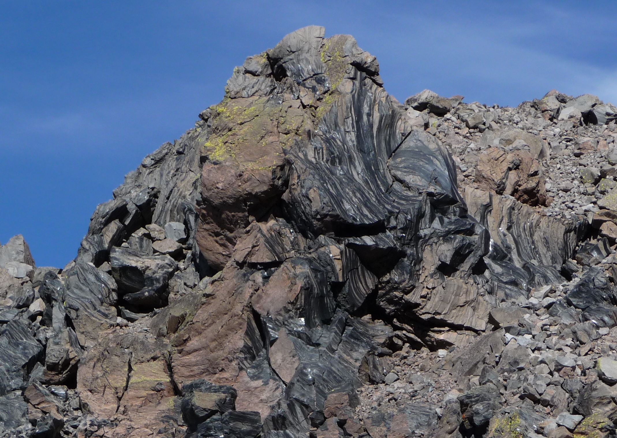
Obsidian flow outcrop along northern end of Mono Craters. Image courtesy Wikipedia Commons
The 10 km long Inyo chain has 7 rhyolitic lava domes, several phreatic craters and an apron of pyroclastic and flow deposits. The oldest unit is North Deadman dome, undated but thought to be 4 – 6,000 years old (0.04 km3) and Wilson Butte (0.05 km3). Both are crystal poor rhyolite. Both would be classified as part of the Mono chain if not for the change in direction of the chain. The Inyo dike injection in the mid-1300’s led to sequential eruption of three domes each preceded by substantial pyroclastic eruptions. The last of these was followed by phreatic eruptions from nearby Inyo craters. Total eruptive volume was 0.4 km3 of lavas and 0.22 km3 of pyroclastic falls.
Panum Crater near the southern edge of Mono Lake on the northern end of the Inyo chain is surrounded by a tephra ring. There are several small rhyolite plugs within the crater. The excavation of the crater took place after the North Mono Plinian ashfalls. There were a series of pyroclastic flows and surges and at least one block and ash flow.

Panum Crater clearly showing tuff ring and multiple domes in the ring. Image courtesy Zippity Go Global
During the pyroclastic eruptions of the Inyo Craters and possibly before the extrusion of the domes, phreatic explosions blasted three craters in the south flank of Deer Mountain. Two of these craters now contain small lakes and are dated between 1340 and 1460 AD. Several additional phreatic explosion craters erupted around 1 km to the NW along a NW trending fault zone. The three aligned Deer Mountain craters were probably formed by the interaction of the dike with ground water. No juvenile magma was ejected. There are other phreatic craters and deposits 5 km to the south on the north face of Mammoth Mountain. These craters were created around 1500, possibly at the same time as those of Inyo Craters.
The source of the Inyo dike is unknown but may be a combination of several residual / new magmas. There is a low velocity zone around 7 km below the NW moat and a shallow storage 3 – 6 km north of the caldera for the Mono component. The dike may be only a feeder of new magma, though this is highly speculative.

Eruptive history of Mono-Inyo / Mono Craters over the last 5,000 years. Screen capture from Response Plan for Volcano Hazards in the Long Valley Caldera, USGS Bulletin 2184, 2002
There are still younger eruptions at the northern end of the Mono-Inyo chain in Mono Lake. There are several small dacite cinder cones and lava flows that form Negit Island and the NE corner of Paoha Island. The eastern third of Paoha Island is a small hydrothermally altered rhyodacite dome and a cluster of phreatic explosion craters. The northern third of Paoha is a rhyolite dome or invasive flow. Most of Paoha Island is uplifted lake sediments probably caused by the rhyolite dome intrusion. The uplift caused slides from the island extending at least 2 km into the lake. The oldest dacites is younger than 0 AD and the youngest around 1600 AD. The extrusion of the rhyolite may be dated between 1720 – 1850.

Paoha Island, Mono Lake, CA. Recent eruptive center is upper right on the island. Clustered basaltic cinder cones of Negit Island is upper center left. Image courtesy KenJet, Flickr
The thickest ashfalls from Mono-Inyo eruptions are locally well preserved. Many of these have produced Plinian to sub-Plinian columns in the 1 – 8 km range. Duration of these events is thought to be hours to days. Short lived blasts may have reached to 20 km.
Surface thermal activity along the Mono-Inyo chain is generally restricted to the northern and southern ends of the chain. To the south, active fumaroles are on the north and south slopes of Mammoth Mountain. In Mono Lake, fumaroles and hot springs are located on Paoha Island and NE of the Black Point cinder cone.

Mono Lake showing Paoha and Negit Islands and Black Point basaltic fissures to the NW. Image courtesy NASA Visible Earth Landsat image
The relatively passive and most recent Paoha Island eruptions were driven by basaltic magmas. Activity uplifted lake bottom sediment by a rhyolite cryptodome, several small dacite cinder cones and a lava flow. Pyroclastic eruptions 650 years ago at Mono and Inyo Craters likely did impact local natives, though there is no written or oral tradition of those eruptions. 2 – 8 cm of ash and pumice from these eruptions did fall on the current site of Mammoth Lakes.

Fault map of Long Valley region and the greater Walker Lane. Image courtesy CJ Willis, 2014
Tectonics
We previously covered the greater Walker Lane tectonics in two posts October 2018 here in VH. The Walker Lane Tectonics and Walker Lane Volcanic Fields posts are a good place to start for the overall regional tectonics. We will cover more localized tectonics in this portion.
The Walker Lane has a significant ongoing earthquake threat, most recently demonstrated by the pair of earthquakes near Ridgecrest on July 4 and 5, 2019. Large earthquakes up to the M 7.8 of 1872 are possible, with earthquakes greater than M 7.0 relatively common.
USGS 1692 models the formation of the Long Valley magma chamber as a product of Basin and Range extension that stopped and started. Initial volcanic activity was due to thinning of the crust due to Basin and Range extension. Rapid extension along Owens Valley and the East Sierra frontal fault zone began some 4 Ma. This allowed decompression melt to reach the surface and fuel early volcanic activity. Extension slowed 3 Ma and stopped by 2.5 Ma. Rising basalts pooled and generated large volumes of trapped dacite. Initial small isolated chambers gradually coalesced into a large megachamber which fed the Glass Mountain rhyolites.
Renewed regional extension shortly before the Bishop Tuff eruption caused rapid injection of basalt into the magma chamber. These basalts spread laterally in multiple sheets along the floor of the chamber, possibly triggering the eruption. Basalt continued upwelling after the eruption erupting as the Early and Moat Rhyolites. Injection of new basalts into the root of the magma system appears to have kept the system active over the last 1 Ma. The chamber is thought to have a roof 5 – 7 km and a floor 11 – 15 deep with a volume 500 – 1,500 km3.

Inyo Craters on the south flank of Deer Mountain. Image courtesy US Forest Service, Inyo National Forest
Conclusions
USGS threat analysis of eruptions from Long Valley is near term basaltic eruptions are much more likely than explosive rhyolite eruptions from the caldera. Several basaltic eruptions took place at the base of Mammoth Mountain and in Devil’s Postpile around 100,000 years ago, at June Lake around 30,000 years ago, at Black Point around 13,000 years ago, and at Red Cones around 5,000 years ago. Current unrest at Long Lake may lead to a small basaltic eruption west of Mammoth Mountain or SE of it near the CO2 tree kill area, both which were sites of relatively recent basaltic eruptions. While uplift of the resurgent dome within the main caldera may indicate basalt injection and a heightened possibility of eruption, the worldwide record of unrest at 60 large calderas documented by Newhall and Dzurisin in 1988 led to only 10 eruptions of all sizes. Possible? Yes. Likely? Probably not.

Earthquake dome from the top of Deer Mountain. Image courtesy Wikimedia Commons
Additional Information
Most recent eruption of the Mono Craters, Eastern Central California
https://volcanoes.usgs.gov/volcanoes/mono_inyo_craters/mono_inyo_craters_geo_hist_16.html
https://pubs.usgs.gov/bul/b2185/b2185.pdf
https://pubs.usgs.gov/circ/1982/0877/report.pdf
https://en.wikipedia.org/wiki/Mono%E2%80%93Inyo_Craters
https://volcano.si.edu/volcano.cfm?vn=323120
https://link.springer.com/content/pdf/10.1007%2F11157_2016_32.pdf
https://link.springer.com/chapter/10.1007/11157_2016_32
http://citeseerx.ist.psu.edu/viewdoc/download?doi=10.1.1.595.2557&rep=rep1&type=pdf
https://pubs.usgs.gov/dds/dds-81/Intro/facts-sheet/fs073-97.pdf
http://seismo.berkeley.edu/~manga/blacketal2016.pdf
https://link.springer.com/article/10.1007/BF00324565
https://academic.oup.com/petrology/article/38/12/1661/1605144
https://pubs.usgs.gov/pp/pp1692/pp1692.pdf
https://www.sciencedirect.com/science/article/abs/pii/S0377027304001635


Great work Gran…on 5-15-2020 there was a 6.1 to the east of mono lake which appear to be from unnamed fault line in the Candelaria hill extending to the Monte Cristo hills and valley, which have been followed by at least a hundred aftershocks a day.
I am a three to 4 hour drive from the area and travel there regularly.
LikeLike