

Paricutin volcano, lava flow and buried church. http://www.amusingplanet.com/2014/08/paricutin-volcano-that-grew-out-of.html
The Michoacan – Guanajuato volcanic field is located in the center of the Trans-Mexican Volcanic Belt (TMVB). It is one of ten monogenetic volcanic fields making up the belt. It is also the largest in both area and in the number of volcanic features, including over 1,100 scoria cones, 400 small basalt shield volcanoes, around 22 maars, and associated lava flows. Total area is around 40,000 km2. The field includes two stratovolcanoes, one of which is thought to be extinct and the other that has not been studied. The field hosts over a third of all monogenetic features in the TMVB. It is the largest subduction-related monogenetic volcanic field in the world.
The two most recent eruptions in the field are monogenetic cinder cones at El Jorullo (1759 – 1774) and Paricutin (1943 – 1952). Previous posts on volcanoes the TMVB discussed Colima and Paricutin. Links to both posts are in the Additional Information section of this post.

Road map of central Mexico with major stratovolcanoes as yellow triangles. Monogenetic volcanoes are red triangles. The MGVF is centered in and around the rectangle in the center. Screen capture from Siebe, et all.
Colima is 143 km to the west. Popocatepetl is 526 km to the east. Both of these massive active stratovolcanoes are located on the active southern edge of the TMVB.
The field gets its name from the two Mexican states it straddles. Michoacan is south and west. Guanajuato is north and a bit east. Both states are west of Mexico City. Michoacan has a shoreline on the Pacific Ocean. It is populated by 4.4 million. Guanajuato is entirely landlocked and has 5.9 million living in it. The relevant portions of both states are quite high, with lowlands some 1,700 m above sea level.

Shaded digital elevation of MGVF. Paricutin, Tancitaro and El Jorullo are at lower left. Screen capture from Perez-Lopez, et all.
Volcanoes
The vast majority of volcanoes in the field are monogenetic scoria cones. There are over 20 maars in one main cluster. The rest are scattered throughout the field.
There are another 400 medium sized volcanoes with much larger volumes of eruptive products ranging between 0.5 – 10 km3. The largest of these approaches 50 km3. Unfortunately, these larger volcanoes have not been closely studied, and activity leading to their creation and growth is not well understood. There are also 61 lava flows not associated with cones.

Cerro el Astillero cinder cone and relatively young lava flows. Photo courtesy Smithsonian GVP. https://volcano.si.edu/volcano.cfm?vn=341060
78 volcanoes are classified as younger than 40,000 years before present. Their total volume is 31 km3, meaning the eruption volume rate is in the neighborhood of 0.8 km2 per 1,000 years.
Most of the recognized shields are topped with either a small lava dome or a scoria cone. Others look like composite cones built by a combination of lava flows and pyroclastic deposits. The slopes of these composite cones are gentle, at less than 10 degrees, slightly steeper than Icelandic shields. Many shields are made of thick aa to blocky andesite lavas. The shields generally measure 3 – 8 km in diameter, top out at 300 – 700 m and have volumes in the 1.0- 10.0 km3 range, generally smaller than similar Icelandic structures.

Schematic of distribution of cinder cones / monogenetic volcanoes in the MGVF. Screen capture from Perez-Lopez et all.
The maars are relatively scarce, making up less than 2% of all volcanic structures in the field. Over half of them are clustered near Valle de Santiago in a river valley in the northern margin of the field. The rest of them are scattered across the field. Scarcity of maars is thought to indicate that conditions favoring their formation are rarely met in the field. And those conditions appear to be related to the amount of water ascending magmas encounter on the way to the surface; the more water, the more pyroclastics, the more ashy and explosive the eruptions, and the greater chance of the eruption creating a maar.

Maars in Valle de Santiago. Photo courtesy Aranda-Gomez, et all. http://boletinsgm.igeolcu.unam.mx/bsgm/index.php/component/content/article/149-sitio/articulos/cuarta-epoca/6501/784-6501-13-aranda
The cluster of maars measures over 50 km long and is oriented roughly NNW – SSE. It is thought to be associated a fault system or a deep crustal weakness zone. Block rotations may also be a factor. Initial volcanic activity was basaltic and andesitic, building numerous small shield volcanoes starting some 6.9 Ma. Maar and cinder cone activity followed. Maar activity dates from 2.4 Ma to as recent as 75,000 years ago.
The small to medium sized volcanic centers have overlapping distributions. Older medium sized volcanoes are found more frequently than the smaller ones. Cinder cones in the north are also older than those in the south, suggesting movement of activity to the south over time. The small volcanoes are generally located between medium sized volcanic centers or on their lower flanks. Lava flows out of these cones are generally much younger than the volcanoes themselves, indicating that lava flows out of scoria cones take place rather later in the eruptive sequence. This is an oddity, as lava flows out of Paricutin started within days of its initial eruption.

Cross section of typical deposits from a growing scoria cone. This one is a quarry in the side of El Caracol. Screen capture from Seibe, et all.
All dated medium sized volcanoes in the north are older than 1 Ma. All the dated medium sized volcanoes in the southern portion of the field are younger than 1 Ma. The area of volcanic activity has shifted south around 100 km over the last 1 – 2 Ma. That shift appears to have been abrupt rather than gradual.
Cinder cones are generally found in clusters in the field, with perhaps 75% of them in eight clusters numbering 45 – 159 volcanoes per cluster. Cone alignments are generally 20 – 50 long. Magmas appear to have ascended rapidly through fractures in the crust and between blocks.

Tancitaro volcano. https://californiaavocadocomments.wordpress.com/2015/03/11/interesting-photographs-of-snow-and-hail-in-tancitaro-and-surrounding-areas/
There are only two large stratovolcanoes recognized in the field. The first is Tancitaro at 3,845 m and Patamban at 3,450 m. Tancitaro is believed to be extinct and Patamban has never been studied in detail.
Tancitaro is an andesitic – dacitic stratovolcano that has a sector collapse and associated debris avalanche. The horseshoe shaped crater is 4 km wide by 5.3 km long. The deposit is some 66 km long and covers 1,155 km2. Total volume of the slide is estimated at 20 km3. It was active around 800,000 – 237,000 years ago. Paricutin is 11 km NE of the peak of Tancitaro.
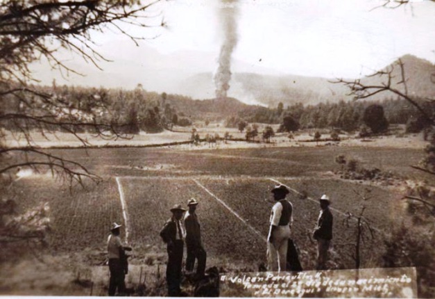
Paricutin second day of the volcano, Feb 21, 1943. Photo courtesy Amusing Planet. http://www.amusingplanet.com/2014/08/paricutin-volcano-that-grew-out-of.html
Eruptions
Eruption rates are just being defined. An area near the Tacambaro area has at least 13 eruptions within the Holocene. This works out at around 800 years between eruptions, one of the highest known monogenetic eruption rates within a small area driven by subduction.
The field has been active for around 5 Ma with activity generally moving from north to south over the last 2 Ma, although there is some disagreement over this movement. An alternate suggestion is that volcanism has not migrated south over time, but has instead become more intense at the arc front to the south over time. This may or may not be a distinction without a difference. One paper describes a change in lava composition around 1 Ma ago.
The most recent eruptions started in 1943 and 1759. Another six cinder cones were dated between 3,800 – 29,000 years old. There are 71 more cinder cones that may be in that range as their lava flows are similar in appearance to the six dated cones.
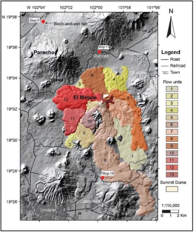
El Metate volcano with lava flow units depicted. Screen capture from Siebe, et all.
The most recent monogenetic shield eruption took place over a 30-year period somewhere around 1250 – 1290 AD from the El Metate volcano, the youngest shield in the field. The volcano today has a minimum volume of 9.2 km3. Its andesitic lava flows cover 103 km2. Given its young age and location, the eruption likely forced local human populations to migrate. This is the largest eruption in the Trans-Mexican Volcanic Belt during the Holocene and is the largest andesitic effusive eruption in the world for this period. The large volume of lavas erupted in a short time present a significant threat for similar eruptions in the future. El Metate is 25 km east of Paricutin.
The initial batch of magmas appears to have stalled a while at 7 – 10 km before it was erupted. It fractionated and crystalized a bit before it was remobilized. The second, hotter batch bypassed it without mixing or mingling and erupted. That eruption mobilized the first batch which closely followed. There were two different flow units with different chemistry likely due to two separate magma batches fueling the eruption. Magma viscosity was high, though the eruption was effusive, likely due to an open system degassing during the eruption. There are at least 12 flow units from this eruption.
Next most recent volcano is El Jorullo, a monogenetic scoria cone that was active for a 15-year long period 1759 – 1774. 15 years is among the longest known scoria eruption. There are six smaller vents with associated cinder cones around El Jorullo. Lava from the vents cover 9 km2 around the volcano. Initial magmas were basaltic to andesitic. Later lavas were higher in silica content as the magma evolved a bit before it reached the surface.

Comparison of lava flow fields from El Jorullo (top) and Paricutin (bottom). Screen capture from Rowland, et all.
Initial eruptions were phreatic and phreatomagmatic with significant ash, mud and water. Toward the end of the eruption, the lava flows are not covered with ash, indicating the water supply may have dried out a bit, and the eruption became more magmatic in nature. There are reports of a small eruption in 1958, which would be a big deal for a scoria cone as they typically have a single eruptive sequence. There are occasional fumaroles at the site. The eruption is classed as a VEI 4. El Jorullo destroyed a rich agricultural area with its eruption, ash deposits, and lava flows. El Jorullo is some 85 km SE of Paricutin.
The most recent volcano in the field was Paricutin, starting in 1943. https://volcanohotspot.wordpress.com/2015/03/13/paricutin-mexico-my-first-volcano/

Tectonic schematic of Trans-Mexican Volcanic Belt. Lines are distances of subducted plate beneath the North American Plate. Screen capture from Ferrari, MantlePlumes.
Tectonics
The Trans-Mexican Volcanic Belt (TMVB) is a subduction driven zone with the Cocos and Rivera Plates subducting under the North American Plate. The Middle America Trench is offshore and defines the offshore subduction zone.
Fluids powering volcanic activity on the belt are released in a 40 – 100 km wide belt beneath the frontal part of the arc. East of 101 degrees, crust thickness is 50 – 55 km. West of that line, crust thickness is 35 – 40 km. The belt evolved in four stages:
- 20 – 10 Ma, initial andesite arc moved inland showing progressively drier melting, and eventually slab melting
- 11 Ma – Present, a pulse of mafic volcanism migrated from west to east, reaching the Gulf of Mexico 7 Ma. This is thought to be the eastward propagation of a slab tear.
- 5 – 3 Ma, the volcanic front started moving south toward the trench with silicic volcanism. Small volume intraplate basalts erupted since 5 Ma. This is consistent with slab rollback.
- Present, the modern arc has a frontal belt with flux and slab melting magmas. The rear belt has more differentiated magmas, mafic lavas, little to no evidence of subduction fluids.
The entire belt is rotated some 15 degrees north of parallel to the trench, with the eastern end of the belt being farther away.

Schematic of proposed slab tear beneath the Central Mexican Volcanic Belt 10.9 – 7.8 Ma. Screen capture from Ferrari, MantlePlumes.
The western portion of the Michoacan – Guanajuato volcanic field has three major rift zones, Tepic – Zacoalco, Colima, and Chapala. It is located to the east of the axis of the Chapala. There are also three blocks in play, the Jalisco to the west, the Michoacan – Oaxaca block to the south, and the Guerrero block to the east.

Schematic of crustal blocks in central Mexico. MGVF is in the center of the drawing. Screen capture from Uribe-Cifuentes, et all.
Rotational movement of the blocks driven by the subduction stress on the region has opened any number of fault lines, which in turn provide lines of crustal weakness that allow magmas to make their way to the surface. Several stratovolcanoes and cinder cone fields are located at the intersections of fault systems. These include but are not limited to Nevado de Toluca, Popocatepetl, Jorullo, and the Valle de Santiago maar field.
While surface faults are well known, there is not a lot of information available for middle and lower crust in strike-slip faulting environments. Some gravity anomalies correlate with the general trend of volcanic activity in the central and western sections. But we don’t have enough information to correlate deep crust structure with distribution and type of volcanic activity.

Cross section schematics of low velocity zones in southern Mexico. MGVF is at the farthest north cross section. Photo courtesy Caltech. http://web.gps.caltech.edu/~clay/MexWeb/MexSubduction.html
The entire field is underlain by several low velocity zones that merge with one another at depth. The most intense of these is located beneath the Colima volcano system to the west. There is a shallow low velocity to the south of the Chapala Rift. It merges with a deeper system to the SE at depths greaterh than 10km spreading under the entire field. The Colima and Michoacan – Guanajuato low velocity bodies merge at depths greater than 17 – 24 km. Such a low velocity zone is consistent with either a deep source of magma mixing or a common magma source at depth. If the low velocity zone research is correct, there will be plenty of fresh magma to power future eruptions.

El Jorullo lava flow. Screen capture from Poch, et all.
Conclusions
The Michoacan – Guanajuato volcanic field is one of the most prolific monogenetic volcanic fields in the world. Its activity has been relatively recent with two new cinder cone complexes within the last 300 years. Monogenetic shield volcanoes, while active longer, are also relatively recent, as are lava flows that do not have a readily identified source (fissure eruptions). The area continues to be seismically unstable as the subduction and slab tearing action continues to jostle, rotate, and rearrange the three primary crustal blocks involved. There are extensive low velocity zones between the region and millions of people with ringside seats for future eruptions.
This is a beautiful part of the world that will only get more dangerous to live in as the population continues to increase.

El Jorullo cinder cone. Photo courtesy gettyimages. http://www.gettyimages.com/detail/news-photo/el-jorullo-cinder-cone-volcano-in-the-michoacan-guanajuato-news-photo/548666107#el-jorullo-cinder-cone-volcano-in-the-michoacanguanajuato-volcanic-picture-id548666107
Additional Information
http://plate-tectonic.narod.ru/volcanparicutinphotoalbum.html
https://geographic.org/photos/volcanoes/volcano_photos_47.html
http://ojs.geofisica.unam.mx/ojs6/index.php/RGI/article/view/544
https://www.wou.edu/las/physci/taylor/g407/perez_lopez_etal_2011_cinder_cones.pdf
http://www.tandfonline.com/doi/abs/10.1080/00206819909465192
http://www.sciencedirect.com/science/article/pii/0377027394900167
http://www.sciencedirect.com/science/article/pii/S0377027310002350
http://www.sciencedirect.com/science/article/pii/0377027385900071
https://www.jstage.jst.go.jp/article/geochemj1966/38/1/38_1_43/_article
http://onlinelibrary.wiley.com/doi/10.1029/94JB00494/full
http://www.sciencedirect.com/science/article/pii/S0169555X14002451
http://www.redalyc.org/pdf/568/56838402.pdf
http://www.geo.mtu.edu/EHaz/ConvergentPlatesClass/MGVF/Hasenaka-Carmichael_1985.pdf
http://www.giseis.alaska.edu/input/west/papers/2011_bullVolc_gardine_paricutin.pdf
https://volcanohotspot.wordpress.com/2015/02/24/eruptions-continue-at-colima-mexico/
http://adsabs.harvard.edu/abs/2008AGUFM.H44B..08M
http://usuarios.geofisica.unam.mx/cruz/Spica_et_al_JVGR_2014.pdf


Thanks, Agimarc for giving us the larger picture. I only knew of Paricutin.
LikeLike
For the Icelandically inclined, a visualization of the recent swarm in Tjörnes Fracture Zone
Data from NOAA (topography) and IMO (earthquakes)
Color : Blue for oldest Red for Youngest
LikeLike
I’ve been hoping you’d come up with this, thanks, dfm! Amazing how it rises in 3-4 distinct batches side by side and one after another. I wonder if this is now one broad dike or three separate ones.
LikeLike
Hi Granyia
Iceland quakes are always a pleasure to look at because there are this sort of “upwelling”.
I do not know enough the geology of this part of Iceland to emit suggestions. It is true that there are very distinct events with separate “sheets” . They are distinct in time so it would seem that the magma is trying to find a way up.
LikeLike
Thank you, agimarc! I still don’t get why there are clusters of monogenetic cones rather than central volcanoes. I mean, the magma source below does not disappear after an eruption. Yet, the next batch creates a new path and erupts a few kilometers further away, even within a relatively short time. In other places of the world magmas would go a long distance sub-surface in order to reach a pre-existing outlet – like Katmai>Novarupta.
Is this perhaps because this area is highly cracked and broken by the very complex tectonic movements? So each (even small) batch of magma would find an almost direct way up and out without having the time to create a permanent plumbing system? (But then, the Katmai region has complex tectonics as well.)
LikeLike
Howdy Granyia –
I think it has a lot to do with how cracked and broken the various blocks are and how they are jostling against one another. Large stratovolcanoes appear at intersections of fault lines – Colima and Popocatepetl for example. Looked like an initial slug of magma at El Jorrulo rose and then stalled until remobilized by the slug of magma that finally made it to the surface. I still don’t understand completely how or why monogenetic fields work, which is one of the reasons I keep on looking at them, There are similarities with NM, Arizona, Utah, Mexico, and Nevada though I have not figured out a way to describe those similarities yet. Cheers –
LikeLike
New post is up! 🙂
LikeLike
I have not studied volcanology. I live on the side of Estribo volcano in Patzcuaro, Michoacan, MX. I am just looking for a good history of first and last eruptions. Is it considered extinct? As I look out my window I see what looks to be another volcano across Lake Patzcuaro. I have spent hours and days researching this but can find nothing definitive. Couild you help a lay person?
LikeLike
Howdy Kitty. Thanks for reading our blog. A quick look into El Estribo looks like it was active 128 – 100,000 years ago and again some 28,000 years ago. The first period build the underlying shield. The most recent built the cinder cone capping it. Haven’t looked far enough to figure out what is on the other side of the lake. But thank you for the suggestion for a future post. It will be a while as I am in the middle of our summertime routine and will be busy for the next couple months. Will let you know when the new post is up. Note that neither of us are experts. Merely hobbyists who think these are interesting things to look into and try to figure out how they work. Cheers –
LikeLike
Thanks.
LikeLike
El Estribo went up this morning. Hope it answers some of your questions. Interesting region you live in. Complex volcanic activity. As always, we are hobbyists rather than experts. Cheers –
LikeLike
Pingback: El Estribo Volcanic Complex, Mexico |
Pingback: Guest Video: Why Do Volcanoes Erupt? – Flight To Wonder
Pingback: Lamongan Volcanic Field, East Java, Indonesia |
Pingback: Sierra La Primavera Volcanic Complex, Mexico |